| Year | Oil | Gas | ||||
|---|---|---|---|---|---|---|
| Production (bbls) |
Wells | Cumulative (bbls) |
Production (mcf) |
Wells | Cumulative (mcf) |
|
| 1995 | 45,153 | 42 | 1,658,486 | 375,529 | 12 | 5,778,845 |
| 1996 | 39,540 | 31 | 1,698,026 | 442,406 | 24 | 6,221,251 |
| 1997 | 26,434 | 47 | 1,724,460 | 70,539 | 22 | 6,291,790 |
| 1998 | 24,804 | 18 | 1,749,264 | - | - | 6,291,790 |
| 1999 | 20,555 | 53 | 1,769,819 | - | - | 6,291,790 |
| 2000 | 21,547 | 45 | 1,791,366 | - | - | 6,291,790 |
| 2001 | 27,217 | 45 | 1,818,583 | 4,126 | 1 | 6,295,916 |
| 2002 | 24,753 | 59 | 1,843,336 | - | - | 6,295,916 |
| 2003 | 23,569 | 52 | 1,866,905 | - | - | 6,295,916 |
| 2004 | 21,485 | 54 | 1,888,390 | - | - | 6,295,916 |
| 2005 | 22,134 | 51 | 1,910,524 | - | - | 6,295,916 |
| 2006 | 19,282 | 51 | 1,929,806 | - | - | 6,295,916 |
| 2007 | 23,583 | 46 | 1,953,389 | - | - | 6,295,916 |
| 2008 | 23,890 | 50 | 1,977,279 | - | - | 6,295,916 |
| 2009 | 20,588 | 44 | 1,997,867 | - | - | 6,295,916 |
| 2010 | 19,423 | 56 | 2,017,290 | - | - | 6,295,916 |
| 2011 | 18,983 | 68 | 2,036,273 | - | - | 6,295,916 |
| 2012 | 20,285 | 62 | 2,056,558 | - | - | 6,295,916 |
| 2013 | 14,919 | 81 | 2,071,477 | - | - | 6,295,916 |
| 2014 | 16,065 | 80 | 2,087,542 | - | - | 6,295,916 |
| 2015 | 12,968 | 76 | 2,100,510 | - | - | 6,295,916 |
| 2016 | 9,543 | 74 | 2,110,053 | - | - | 6,295,916 |
| 2017 | 6,878 | 74 | 2,116,931 | - | - | 6,295,916 |
| 2018 | 9,341 | 68 | 2,126,272 | - | - | 6,295,916 |
| 2019 | 13,367 | 68 | 2,139,639 | - | - | 6,295,916 |
| 2020 | 6,615 | 64 | 2,146,254 | - | - | 6,295,916 |
| 2021 | 4,542 | 55 | 2,150,796 | - | - | 6,295,916 |
| 2022 | 3,832 | 50 | 2,154,628 | - | - | 6,295,916 |
| 2023 | 4,147 | 26 | 2,158,775 | - | - | 6,295,916 |
| 2024 | 2,878 | 20 | 2,161,653 | - | - | 6,295,916 |
| 2025 | 2,353 | 28 | 2,164,006 | - | - | 6,295,916 |
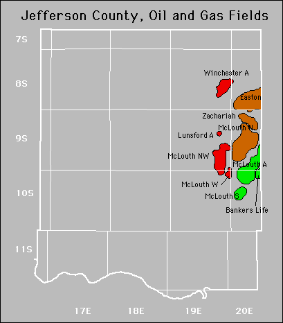

| Active | |||
|---|---|---|---|
| Bankers Life Easton Forest City Coal Gas Area Lunsford |
Mclouth Mclouth North Mclouth Northwest Mclouth South |
Mclouth West Winchester Zachariah Zachariah West |
|
No Abandoned fields.
Gas Storage Fields