KGS Home Page Oil and Gas Index Page County Production Page

Cowley County--Oil and Gas Production


Production


Year Oil Gas
Production
(bbls)
Wells Cumulative
(bbls)
Production
(mcf)
Wells Cumulative
(mcf)
1995 769,547 1401 174,512,909 385,91576 39,739,552
1996 773,213 1065 175,286,122 328,37191 40,067,923
1997 656,736 995 175,942,858 216,10580 40,284,028
1998 545,289 910 176,488,147 182,44755 40,466,475
1999 464,720 762 176,952,867 67,60954 40,534,084
2000 468,067 773 177,420,934 59,80150 40,593,885
2001 486,120 731 177,907,054 16,30443 40,610,189
2002 484,587 725 178,391,641 44,21549 40,654,404
2003 458,792 718 178,850,433 68,77531 40,723,179
2004 439,501 706 179,289,934 127,14631 40,850,325
2005 430,622 712 179,720,556 95,77031 40,946,095
2006 442,052 707 180,162,608 82,44040 41,028,535
2007 432,850 692 180,595,458 190,24639 41,218,781
2008 443,961 704 181,039,419 164,85451 41,383,635
2009 460,119 683 181,499,538 250,57062 41,634,205
2010 442,117 682 181,941,655 155,71047 41,789,915
2011 455,942 711 182,397,597 80,70450 41,870,619
2012 478,897 724 182,876,494 60,40740 41,931,026
2013 519,676 728 183,396,170 108,38350 42,039,409
2014 667,055 760 184,063,225 148,53247 42,187,941
2015 662,783 754 184,726,008 116,16044 42,304,101
2016 586,312 748 185,312,320 42,30134 42,346,402
2017 540,035 733 185,852,355 29,13630 42,375,538
2018 527,343 747 186,379,698 2,6831 42,378,221
2019 562,840 730 186,942,538 13,4924 42,391,713
2020 502,080 687 187,444,618 2,5081 42,394,221
2021 536,670 716 187,981,288 2,9061 42,397,127
2022 556,462 728 188,537,750 2,4741 42,399,601
2023 547,057 720 189,084,807 2,4121 42,402,013
Updated through 12-2023.
Note: bbls is barrels; mcf is 1000 cubic feet.

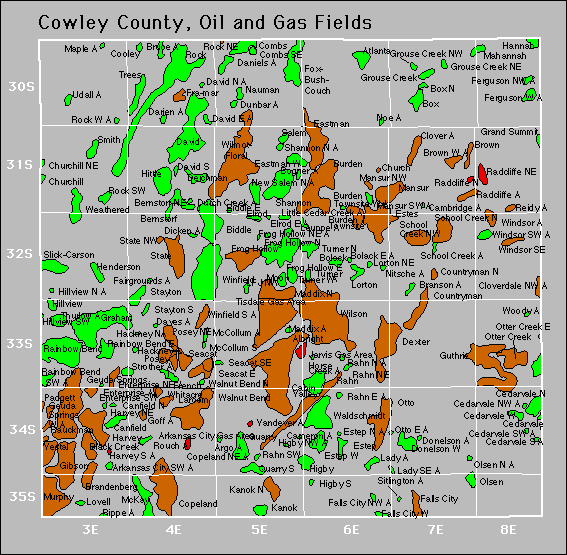
County Map

Cowley County oil and gas map
oil=green, gas=red, oil and gas=brown

Fields

Also available is a text file containing field summary data for all fields in this county.
Active
Akron
Albright
Albright Southwest
Arkansas City Gas Area
Atlanta
Bernstorf
Bernstorf Northeast
Biddle
Biddle East
Big Badger
Big Badger South
Black Creek
Bolack
Bolack East
Boucher
Box
Box North
Brandenberg
Branson
Brown
Brown West
Bruce
Burden
Burden Townsite
Burden Townsite Southwest
Burden Townsite West
Cabin Valley
Canfield
Canfield North
Cedarvale
Cedarvale North
Cedarvale Northwest
Cedarvale South
Cedarvale Southwest
Cherokee Basin Coal Area
Church
Churchill
Churchill Northeast
Clay
Clover
Cloverdale
Cloverdale Northwest
Combs
Combs Southeast
Cooley
Copeland
Copeland East
Copeland Northeast
Countryman
Countryman North
Daniels
Darien
Daves
David
David East
David North
David South
Deichman
Dexter
Dicken
Donelson
Donelson West
Dunbar
Eastman
Eastman East
Eastman West
Elrod
Enterprise Northeast
Enterprise Southwest
Estep
Estep North
Estep West
Estes
Ewers
Fairgrounds
Falls City
Falls City East
Falls City North
Falls City Northwest
Falls City West
Ferguson Northwest
Ferguson West
Fox-Bush-Couch
Fra-Mar
French
Frog Hollow
Frog Hollow East
Frog Hollow North
Frog Hollow Northeast
Geuda Springs
Geuda Springs West
Gibson
Graham
Grand Summit
Grouse Creek
Grouse Creek Northeast
Grouse Creek Northwest
Guthrie
Hannah
Harvey
Harvey Northeast
Harvey South
Henderson
Higby
Higby Northwest
Higby South
Hillview
Hillview North
Hillview Southwest
Hittle
Hogback Basin
Horse Creek
Kanok
Kanok North
Kennedy
Lady
Lady Southeast
Larcom
Lfj Northwest
Lorton
Lorton Northeast
Lovell
Lovell Southwest
Maddix North
Mahannah
Mansur
Mansur Northwest
Mccollum
Mccollum South
Mckay
Moon
Murphy
Nauman
Nauman Northeast
New Salem North
Noe
Olsen
Olsen North
Otter Creek
Otter Creek East
Otter Creek North
Otto
Otto East
Padgett
Polecat Creek
Posey
Posey Northeast
Quarry
Quarry South
Radcliffe
Radcliffe North
Radcliffe Northeast
Rahn
Rahn East
Rahn North
Rahn Northeast
Rahn Southwest
Rainbow Bend
Rainbow Bend East
Rainbow Bend Southwest
Rauckman
Reidy
Rock
Rock Northeast
Rock Southwest
Rock West
Rouch
Salem
School Creek
School Creek North
School Creek Northwest
Seacat
Seacat East
Seacat Southeast
Shannon
Shannon North
Sitlington
Slick-Carson
Smith
Smith Northeast
State
State Line
State Northwest
Stayton
Stayton South
Strother
Sundance
Tisdale Gas Area
Trees
Turner
Turner North
Turner West
Udall
Vandever
Vestal
Waldschmidt
Walnut Bend
Walnut Bend North
Weathered
Whitacre
Wilmot-Floral
Wilson
Windsor Southeast
Winfield
Woody

Abandoned
Argo
Arkansas City Southwest
Bogner
Cambridge
Cameron
Cedarvale West
Dutch Creek
Elrod East
Enterprise
Hackney
Hackney North
Jarvis Gas Area
Lauppe
Little Cedar Creek
Maddix
Mansur Southwest
Maple
Nitsche
Rippe
Thurlow
Windsor
Windsor Southwest
Winfield South

Gas Storage Fields

Collinson


Kansas Geological Survey
Comments to webadmin@kgs.ku.edu
URL=http://www.kgs.ku.edu/PRS/County/abc/cowley.html
Data from Kansas Dept. of Revenue files monthly.