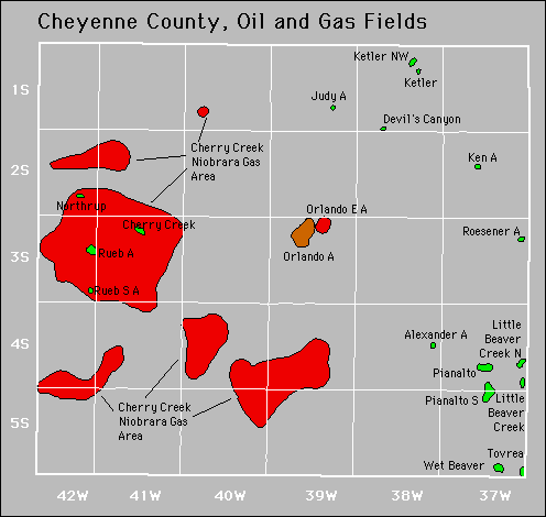
| Year | Oil | Gas | ||||
|---|---|---|---|---|---|---|
| Production (bbls) |
Wells | Cumulative (bbls) |
Production (mcf) |
Wells | Cumulative (mcf) |
|
| 1995 | 45,859 | 25 | 1,401,920 | 474,998 | 49 | 5,411,940 |
| 1996 | 39,408 | 17 | 1,441,328 | 416,708 | 47 | 5,828,648 |
| 1997 | 34,224 | 18 | 1,475,552 | 363,234 | 54 | 6,191,882 |
| 1998 | 35,137 | 18 | 1,510,689 | 312,177 | 51 | 6,504,059 |
| 1999 | 48,970 | 21 | 1,559,659 | 388,061 | 61 | 6,892,120 |
| 2000 | 75,936 | 23 | 1,635,595 | 391,159 | 74 | 7,283,279 |
| 2001 | 95,935 | 21 | 1,731,530 | 546,432 | 128 | 7,829,711 |
| 2002 | 126,196 | 20 | 1,857,726 | 1,137,762 | 130 | 8,967,473 |
| 2003 | 159,143 | 20 | 2,016,869 | 1,503,563 | 167 | 10,471,036 |
| 2004 | 145,853 | 23 | 2,162,722 | 1,896,201 | 222 | 12,367,237 |
| 2005 | 130,132 | 22 | 2,292,854 | 2,003,880 | 248 | 14,371,117 |
| 2006 | 114,202 | 23 | 2,407,056 | 2,121,071 | 273 | 16,492,188 |
| 2007 | 138,484 | 24 | 2,545,540 | 2,308,183 | 331 | 18,800,371 |
| 2008 | 118,237 | 24 | 2,663,777 | 4,204,292 | 572 | 23,004,663 |
| 2009 | 111,539 | 28 | 2,775,316 | 4,788,786 | 611 | 27,793,449 |
| 2010 | 91,045 | 30 | 2,866,361 | 4,485,470 | 639 | 32,278,919 |
| 2011 | 76,205 | 29 | 2,942,566 | 4,545,003 | 660 | 36,823,922 |
| 2012 | 66,378 | 28 | 3,008,944 | 3,890,609 | 658 | 40,714,531 |
| 2013 | 114,750 | 38 | 3,123,694 | 3,254,678 | 619 | 43,969,209 |
| 2014 | 259,058 | 57 | 3,382,752 | 2,913,235 | 574 | 46,882,444 |
| 2015 | 263,263 | 66 | 3,646,015 | 2,610,167 | 572 | 49,492,611 |
| 2016 | 193,081 | 72 | 3,839,096 | 2,087,839 | 586 | 51,580,450 |
| 2017 | 192,657 | 77 | 4,031,753 | 1,961,629 | 573 | 53,542,079 |
| 2018 | 294,122 | 94 | 4,325,875 | 1,641,360 | 565 | 55,183,439 |
| 2019 | 387,298 | 100 | 4,713,173 | 1,478,421 | 543 | 56,661,860 |
| 2020 | 278,588 | 110 | 4,991,761 | 1,418,309 | 539 | 58,080,169 |
| 2021 | 258,214 | 111 | 5,249,975 | 1,254,972 | 538 | 59,335,141 |
| 2022 | 243,561 | 127 | 5,493,536 | 1,119,363 | 563 | 60,454,504 |
| 2023 | 262,466 | 122 | 5,756,002 | 1,016,534 | 554 | 61,471,038 |
| 2024 | 292,592 | 129 | 6,048,594 | 901,782 | 546 | 62,372,820 |
| 2025 | 117,973 | 126 | 6,166,567 | 439,879 | 546 | 62,812,699 |


Abandoned
Alexander
Judy
Ken
Rueb
Rueb South