| Year | Oil | Gas | ||||
|---|---|---|---|---|---|---|
| Production (bbls) |
Wells | Cumulative (bbls) |
Production (mcf) |
Wells | Cumulative (mcf) |
|
| 1995 | 205,552 | 867 | 31,014,270 | 706 | 1 | 187,055 |
| 1996 | 202,289 | 1581 | 31,216,559 | 588 | 1 | 187,643 |
| 1997 | 236,264 | 1529 | 31,452,823 | 42 | 1 | 187,685 |
| 1998 | 227,485 | 1474 | 31,680,308 | - | - | 187,685 |
| 1999 | 206,627 | 1449 | 31,886,935 | - | - | 187,685 |
| 2000 | 205,368 | 1429 | 32,092,303 | - | - | 187,685 |
| 2001 | 200,179 | 1405 | 32,292,482 | - | - | 187,685 |
| 2002 | 185,053 | 1390 | 32,477,535 | - | - | 187,685 |
| 2003 | 168,826 | 1428 | 32,646,361 | - | - | 187,685 |
| 2004 | 174,159 | 1422 | 32,820,520 | - | - | 187,685 |
| 2005 | 169,476 | 1446 | 32,989,996 | - | - | 187,685 |
| 2006 | 180,494 | 1443 | 33,170,490 | - | - | 187,685 |
| 2007 | 188,491 | 1491 | 33,358,981 | - | - | 187,685 |
| 2008 | 186,018 | 1504 | 33,544,999 | - | - | 187,685 |
| 2009 | 183,848 | 1493 | 33,728,847 | - | - | 187,685 |
| 2010 | 186,448 | 1626 | 33,915,295 | - | - | 187,685 |
| 2011 | 221,031 | 1493 | 34,136,326 | - | - | 187,685 |
| 2012 | 251,160 | 1696 | 34,387,486 | - | - | 187,685 |
| 2013 | 251,913 | 1830 | 34,639,399 | - | - | 187,685 |
| 2014 | 243,244 | 1956 | 34,882,643 | - | - | 187,685 |
| 2015 | 206,758 | 2010 | 35,089,401 | - | - | 187,685 |
| 2016 | 183,543 | 2059 | 35,272,944 | - | - | 187,685 |
| 2017 | 174,216 | 2067 | 35,447,160 | - | - | 187,685 |
| 2018 | 164,393 | 2079 | 35,611,553 | - | - | 187,685 |
| 2019 | 136,688 | 2052 | 35,748,241 | - | - | 187,685 |
| 2020 | 120,498 | 1881 | 35,868,739 | - | - | 187,685 |
| 2021 | 112,377 | 1846 | 35,981,116 | - | - | 187,685 |
| 2022 | 114,242 | 1750 | 36,095,358 | - | - | 187,685 |
| 2023 | 119,495 | 1717 | 36,214,853 | - | - | 187,685 |
| 2024 | 140,270 | 1634 | 36,355,123 | - | - | 187,685 |
| 2025 | 151,005 | 1653 | 36,506,128 | - | - | 187,685 |
| 2026 | 39,233 | 1522 | 36,545,361 | - | - | 187,685 |
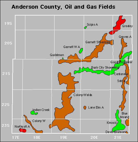

Abandoned
Gas Storage Fields
Colony
North Welda
South Welda