| Year | Oil | Gas | ||||
|---|---|---|---|---|---|---|
| Production (bbls) |
Wells | Cumulative (bbls) |
Production (mcf) |
Wells | Cumulative (mcf) |
|
| 1995 | 390,374 | 1253 | 45,032,045 | 148,257 | 21 | 2,170,685 |
| 1996 | 376,214 | 2470 | 45,408,259 | 190,915 | 25 | 2,361,600 |
| 1997 | 338,290 | 2323 | 45,746,549 | 189,904 | 25 | 2,551,504 |
| 1998 | 256,597 | 2104 | 46,003,146 | 150,772 | 35 | 2,702,276 |
| 1999 | 211,387 | 1929 | 46,214,533 | 170,168 | 38 | 2,872,444 |
| 2000 | 214,651 | 1906 | 46,429,184 | 193,163 | 38 | 3,065,607 |
| 2001 | 222,899 | 1820 | 46,652,083 | 144,776 | 43 | 3,210,383 |
| 2002 | 232,226 | 1814 | 46,884,309 | 157,379 | 63 | 3,367,762 |
| 2003 | 210,359 | 1826 | 47,094,668 | 153,107 | 65 | 3,520,869 |
| 2004 | 207,464 | 1787 | 47,302,132 | 176,722 | 107 | 3,697,591 |
| 2005 | 234,153 | 1847 | 47,536,285 | 354,978 | 133 | 4,052,569 |
| 2006 | 245,699 | 1867 | 47,781,984 | 312,907 | 140 | 4,365,476 |
| 2007 | 214,044 | 1945 | 47,996,028 | 445,752 | 167 | 4,811,228 |
| 2008 | 226,626 | 2017 | 48,222,654 | 429,639 | 189 | 5,240,867 |
| 2009 | 219,839 | 2031 | 48,442,493 | 799,328 | 238 | 6,040,195 |
| 2010 | 216,161 | 2034 | 48,658,654 | 479,469 | 214 | 6,519,664 |
| 2011 | 247,537 | 2050 | 48,906,191 | 364,395 | 183 | 6,884,059 |
| 2012 | 283,005 | 2125 | 49,189,196 | 215,936 | 164 | 7,099,995 |
| 2013 | 304,781 | 2322 | 49,493,977 | 221,517 | 149 | 7,321,512 |
| 2014 | 344,575 | 2455 | 49,838,552 | 183,865 | 143 | 7,505,377 |
| 2015 | 320,116 | 2456 | 50,158,668 | 167,606 | 127 | 7,672,983 |
| 2016 | 289,311 | 2421 | 50,447,979 | 170,083 | 104 | 7,843,066 |
| 2017 | 265,028 | 2588 | 50,713,007 | 190,227 | 101 | 8,033,293 |
| 2018 | 239,771 | 2550 | 50,952,778 | 120,489 | 83 | 8,153,782 |
| 2019 | 227,596 | 2460 | 51,180,374 | 99,705 | 83 | 8,253,487 |
| 2020 | 204,642 | 2238 | 51,385,016 | 131,597 | 83 | 8,385,084 |
| 2021 | 201,482 | 2238 | 51,586,498 | 139,287 | 83 | 8,524,371 |
| 2022 | 212,619 | 2377 | 51,799,117 | 147,088 | 83 | 8,671,459 |
| 2023 | 212,518 | 2376 | 52,011,635 | 139,084 | 89 | 8,810,543 |
| 2024 | 236,954 | 2504 | 52,248,589 | 162,257 | 91 | 8,972,800 |
| 2025 | 246,154 | 2509 | 52,494,743 | 146,957 | 83 | 9,119,757 |
| 2026 | 38,238 | 1965 | 52,532,981 | 24,524 | 83 | 9,144,281 |
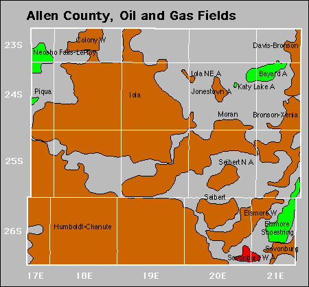

Abandoned
Iola Northeast
Jonestown
Savonburg West
Seibert North
Gas Storage Fields