currently headed by John Morrison of the Independent Oil and Gas Service, Wichita.
| Oil and Gas Fields Added, May 2013 | ||
| Fields are named by the Kansas Geological Society's Nomenclature Committee, currently headed by John Morrison of the Independent Oil and Gas Service, Wichita. |
||
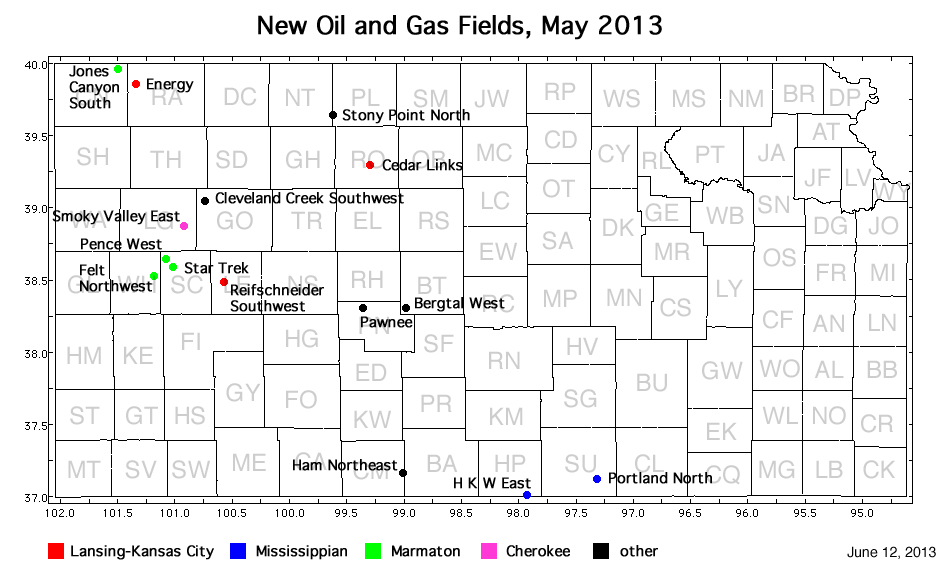
| Field | Well | Operator | API Number | Latitude | Longitude | Location | Pay Zone |
|---|---|---|---|---|---|---|---|
| Bergtal West | Mermis 'A' Unit 1-21 | F. G. Holl Co. LLC | 15-009-25748 | 38.2978556 | -98.9825696 | sec. 21, T. 20 S., R. 15 W. | Unknown |
| Cedar Links | Stahl 1 | Gore Oil Company | 15-163-24071 | 39.2932256 | -99.2934501 | sec. 2, T. 9 S., R. 18 W. | Lansing-Kansas City |
| Cleveland Creek Southwest | Lockwood 1-35 | L. D. Drilling, Inc. | 15-063-22073 | 39.0487523 | -100.7330008 | sec. 35, T. 11 S., R. 31 W. | Lansing-Kansas City and Marmaton |
| Energy | PTL 1-22 | Murfin Drilling Co., Inc. | 15-153-20910 | 39.86224 | -101.3424082 | sec. 22, T. 2 S., R. 36 W. | Lansing-Kansas City |
| Felt Northwest | Berning 1-3 | Lario Oil and Gas Co. | 15-203-20209 | 38.521025 | -101.1783223 | sec. 3, T. 18 S., R. 35 W. | Marmaton |
| H K W East | Dalrymple Farm 3506 1-13H | SandRidge Exploration and Production LLC | 15-077-21900-0100 | 36.9993226 | -97.9216252 | sec. 13, T. 35 S., R. 6 W. | Mississippian |
| Ham Northeast | Charlie Brown 1-24 | Castelli Exploration, Inc. | 15-033-21688-0001 | 37.1537939 | -99.0086307 | sec. 24, T. 33 S., R. 16 W. | Marmaton, Chattanooga |
| Jones Canyon South | Vada 1-17 | Berexco, LLC | 15-023-21360 | 39.9648852 | -101.4972054 | sec. 17, T. 1 S., R. 37 W. | Marmaton Pawnee |
| Pawnee | Joan 1 | Castle Resources, Inc. | 15-145-21701 | 38.3037826 | -99.3565219 | sec. 19, T. 20 S., R. 18 W. | Unknown |
| Pence West | Nightengale 1-28 | Shakespeare Oil Co., Inc. | 15-171-20930 | 38.6387042 | -101.0741774 | sec. 28, T. 16 S., R. 34 W. | Marmaton |
| Portland North | Source 9-41-3-11H | Source Energy Midcon LLC | 15-191-22664-0100 | 37.1148102 | -97.3120399 | sec. 9, T. 34 S., R. 1 E. | Mississippian |
| Reifschneider Southwest | Bockelman 2-19 | Larson Engineering, Inc. | 15-101-22420 | 38.4764817 | -100.5656629 | sec. 19, T. 18 S., R. 29 W. | Lansing-Kansas City |
| Smoky Valley East | Audrey 1 | Blake Exploration, LLC | 15-109-21138 | 38.8737245 | -100.9192555 | sec. 31, T. 13 S., R. 32 W. | Cherokee |
| Star Trek | Captain Kirk 1 | New Gulf Operating LLC | 15-171-20927 | 38.5825646 | -101.0050846 | sec. 18, T. 17 S., R. 33 W. | Marmaton |
| Stony Point North | Lohmeyer 1 | American Patriot Oil LLC | 15-147-20687 | 39.6426268 | -99.6103665 | sec. 6, T. 5 S., R. 20 W. | Unknown |
|
Kansas Geological Survey, Oil and Gas Information Updated June 12, 2013 Comments to webadmin@kgs.ku.edu The URL for this page is http://www.kgs.ku.edu/Magellan/Field/NMC/may_2013.html |