Kansas Geological Survey, Open-file Report 2012-1
A report for Kansas Department of Agriculture, Division of Water Resources
by
Donald O. Whittemore
KGS Open File Report 2012-1
December 2011
Past practices of saltwater disposal associated with the production of oil and gas in the Burrton area of west-central Harvey and east-central Reno counties contaminated fresh ground water in the Equus Beds area of the High Plains aquifer. Saltwater was disposed in surface ponds for about a decade following the discovery of the Burrton oil field in the early 1930s. During this period, a large percentage of the saltwater entered the ground water of the area.
The Burrton Intensive Groundwater Use Control Area (IGUCA) was established in 1984 as a result of concerns of Equus Beds Groundwater Management District No. 2 (GMD2) with the effect of irrigation development on accelerated movement of the saltwater plume. A recent Kansas Administrative Regulation requires that the Burrton IGUCA order be reviewed. The Kansas Department of Agriculture, Division of Water Resources (DWR) has begun the review. The Kansas Geological Survey is providing information on the Burrton saltwater plume in this report to assist the DWR in the technical part of the review process.
Water-quality data were assembled for GMD2 monitoring wells, irrigation wells, and municipal wells of the City of Wichita. Quality control methods were used to identify anomalous values in the data base and to correct them where possible. Graphical and statistical analyses of the data were used to characterize chloride concentration changes in the Burrton salinity plume.
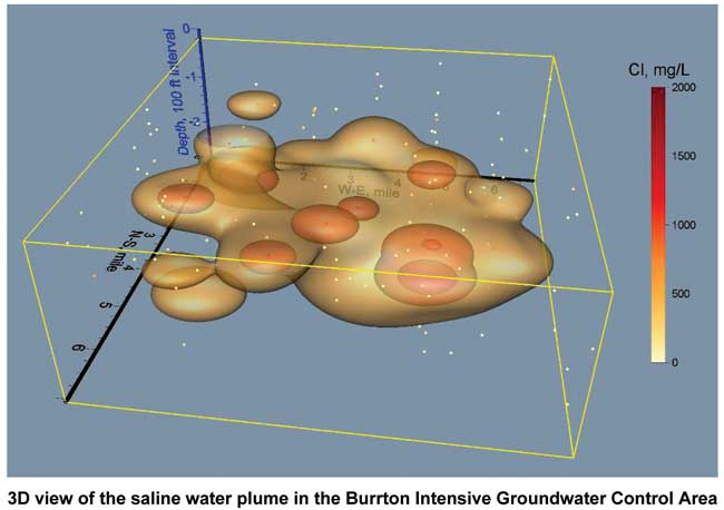
The Burrton plume has migrated eastward and into the deeper portion of the aquifer with time. Substantial clay layers within the aquifer restricted the rate of vertical movement of saltwater and promoted a lateral and vertical "stair-stepping" migration of salinity. The front of the plume, as indicated by the 500 mg/L chloride isosurface, is about a mile away from the nearest municipal supply well in the Wichita well field. During 1982-2010, the plume front advanced at a rate of about 0.8-1.0 ft/day to the east, for a total migration of approximately 1.5 to over 2 miles.
An analysis of mean chloride concentration versus time in ground water sampled by the monitoring network indicates that no statistically significant trend has occurred in the Burrton plume area. This represents a conservation of chloride mass within the aquifer.
A total of 87 permitted points of diversion with active water use exist for supply wells within the IGUCA. The chloride concentration range and median for 35 of these wells (for which sample data exist) are 5-804 mg/L and 112 mg/L, respectively. Long-term changes in the chloride concentration of water pumped from these wells are generally consistent with the eastward and downward movement of saline ground water in the plume, along with dilution by fresh ground water and recharge. Some redistribution of the chloride mass occurs in the plume from the pumping of slightly saline water from within the aquifer to the surface by irrigation wells, followed by infiltration of saline soil moisture to the underlying shallow aquifer.
Based on this study, two additional monitoring wells are recommended for improving the detection of migrating salinity in the area of the Burrton plume. One well is recommended for sampling the middle level of the aquifer near the edge of the advancing salinity plume. Another well is suggested for monitoring the salinity in the deep part of the Burrton plume where no deep monitoring wells exist.
Read the PDF version (revised May 2012, 2.5 MB)
Kansas Geological Survey, Geohydrology
Placed online Feb. 15, 2012
Comments to webadmin@kgs.ku.edu
The URL for this page is http://www.kgs.ku.edu/Hydro/Publications/2012/OFR12_1/index.html