Kansas Geological Survey, Open-file Report 2005-27
by
D.O. Whittemore, E.R. Grieve, D.P. Young, and B.B. Wilson
KGS Open File Report 2005-27
September 2005
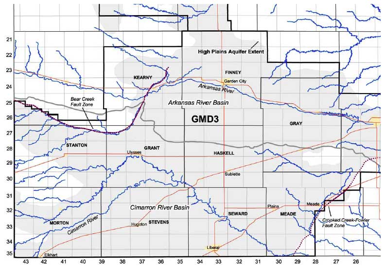
The Cimarron River flows from the northeastern corner of New Mexico to the northwestern corner of the panhandle of Oklahoma, to southeastern corner of Colorado, and enters the southwestern corner of Kansas. The river crosses the High Plains aquifer in southwest Kansas in a broad bow shape from Morton County through northwest Stephens County, southernmost Grant County, and the southwest corner of Haskell County, from northwest to southeast Seward County, and through southwest Meade County (Figure 1). The North Fork of the Cimarron River enters the Cimarron River in southeast Grant County and drains from a watershed area that includes northern Morton County and southern Stanton and Grant counties. Flow in the Cimarron River has historically not been continuous across southwest Kansas but has typically been ephemeral in the middle of its course, particularly in eastern Morton, and in Stevens and Grant counties (see report on the lithology and water levels in the Cimarron River basin by Young et al., 2005). The North Fork of the Cimarron River is also ephemeral.
Figure 1. Base map of southwest Kansas showing political and basin boundaries, highways, rivers and streams, the High Plains aquifer extent, and the Bear Creek and Crooked Creek-Fowler faults. The study area for this report is Seward and Meade counties.
Ground-water table declines in the High Plains aquifer caused by high-volume, consumptive pumping of ground water for irrigation have occurred under the Cimarron River in southwest Kansas. These water-level declines have decreased or eliminated ground-water discharge to the perennial stretches of the river, thereby decreasing flow to or shortening the length of the perennial reaches. The primary area of perennial stretch shortening has occurred in northwest Seward County and the main location of current decrease in perennial streamflow is in southeast Seward County and southwest Meade County.
Natural saltwater derived from evaporite mineral dissolution intrudes from the Permian bedrock into the overlying High Plains aquifer in southeast Seward County and southwest Meade County. The saltwater is primarily of sodium-chloride chemical type, reflecting the dissolution of halite (rock salt) in the Permian strata. The evaporite minerals anhydrite (CaSO4) and gypsum (CaSO4 • 2H2O) are also present in the Permian strata and their dissolution increases the sulfate content of the saline water. The dissolved calcium concentration is limited by carbonate mineral equilibria. Saline water that intrudes to the High Plains aquifer affects the usability of water in parts of the aquifer for irrigation and domestic use due to the high sodium and chloride contents.
The saline water in the High Plains aquifer discharges into the overlying Cimarron River in southeast Seward County and southwest Meade County. The river generally increases in salinity through this area. The decrease in fresh ground-water discharge, caused by declines in ground-water levels, from the High Plains aquifer upstream of the saline water intrusion has resulted in an increase in the salinity of the river.
This report presents maps of the salinity distribution in the High Plains aquifer in Seward and Meade counties based on available data from several sources. It describes water-level changes in the Cimarron River corridor, the shortening of the perennial stretch of the river in Seward County, and the decrease in the river flow at the U.S. Geological Survey (USGS) gaging station in Meade County. It also discusses the resulting increase in salinity in the river caused by the decrease in fresh ground-water discharge from the High Plains aquifer.
OFR2005_27.pdf (1.6 MB)
To read this file, you will need the Acrobat PDF Reader, available free from Adobe.
Kansas Geological Survey, Geohydrology
Placed online Oct. 14, 2005
Comments to webadmin@kgs.ku.edu
The URL for this page is http://www.kgs.ku.edu/Hydro/Publications/2005/OFR05_27/index.html