Kansas Geological Survey, Open-file Report 2002-24
by
Donald O. Whittemore
Prepared for
Equus Beds Groundwater Management District No. 2
and
Division of Water Resources, Kansas Department of Agriculture
KGS Open-file Report 2002-24
May 2002
Equus Beds Groundwater Management District No. 2 (GMD2) and then the Division of Water Resources (DWR), Kansas Department of Agriculture, requested that the Kansas Geological Survey (KGS) review data for water quality and soil chemistry in the vicinity of water permit #43000 located in western Harvey County within the Burrton Intensive Groundwater Use Control Area (Burrton IGUCA). The permit was filed by J. and D. Gray for irrigation use of ground water from the Equus Beds area of the High Plains aquifer in the NW/4, SE/4 of Sec. 34, T. 23 S., R. 3 W. (23S-03W-34DB). The GMD2 provided the data for soil and water analyses and the DWR supplied information on the amount of irrigation water applied. The KGS evaluated the data for the potential of saline water leaching to the shallow ground water of the Equus Beds aquifer.
The application of saline ground water for irrigation under permit #43000 has substantially increased the extractable chloride content of the top 30 inches of soil in the irrigated area. The average chloride concentration of the irrigation water during 1999-2001 was 731 mg/L. The average chloride content in water extracts of soil samples collected from the top 30 inches of soil in October 2001 underlying the irrigated area was 534 mg/L in comparison with 13 mg/L for soils outside the irrigated area. The difference in the mass of chloride extractable from the irrigated and non-irrigated soils is equivalent to 55% of the chloride mass in the irrigation water applied to the land. Thus, 45% of the chloride mass in the applied irrigation water is not accounted for in the top 30 inches of the soil. Most of this chloride is expected to be in the unsaturated zone below the topsoil and in the shallow ground water underlying and just downgradient of the irrigated field.
Continued application of the saline irrigation water can be expected to eventually increase the chloride content of moisture in the unsaturated zone to nearer that of the irrigation water, resulting in substantially increasing the chloride content of the underlying ground water in the shallow zone of the Equus Beds aquifer. Permeable sediments of the shallow aquifer underlie about 10 ft of clay and silty clay and generally overlie a clay layer a few feet in thickness at a depth of about 40 ft under the evaluation area. The average water-table depth is approximately 14 ft, giving a saturated thickness of about 26 ft for the shallow aquifer zone. A domestic well located to the east and a monitoring well (EB14A) of GMD2 to the southeast of the irrigated area for permit #43000 are screened in the shallow aquifer. The probable time for the salinity increase in the shallow aquifer to occur and be easily observed at the domestic well and the monitoring well could be a few to several years after 2001.
Equus Beds Groundwater Management District No. 2 (GMD2) and then the Division of Water Resources (DWR), Kansas Department of Agriculture, requested that the Kansas Geological Survey (KGS) review data for water quality and soil chemistry in the vicinity of water permit #43000 located in western Harvey County within the Burrton Intensive Groundwater Use Control Area (Burrton IGUCA). The permit was filed by J. and D. Gray for irrigation use of ground water from the Equus Beds area of the High Plains aquifer in the NW/4, SE/4 of Sec. 34, T. 23 S., R. 3 W. (23S-03W-34DB). The permit was approved by the DWR in December 1998 subject to conditions imposed by the Board of GMD2. The well was completed in 1999 in the middle zone of the aquifer with a screened interval depth of 112-140 ft in the SW/4, NW/4, SE/4 of Sec. 34, T. 23 S., R. 3 W. (23S-03W-34DBC). The annular space of the well was grouted within the depth intervals of 105-110 ft and 0-25 ft below land surface. The depth interval 25-105 ft was gravel packed and not grouted (GMD2 Fact and Information Sheet, 2000).
In accordance with the permit conditions, the GMD2 collected and analyzed water samples from the irrigation well in 1999. The results showed that the chloride concentration exceeded the 500-mg/L limit established by the GMD2 Board for irrigation use within the Burrton IGUCA. In December 1999, the GMD2 Board recommended to the DWR that additional provisions be included in the terms, conditions, and limitations of the permit. These provisions included sampling and chemical analysis of soils within the irrigated area and outside within non-irrigation land, and additional sampling and analysis of the water pumped from the irrigation well. The GMD2 would then review the results of the analyses for use in future decisions concerning the continuance of pumping within the terms and conditions of the permit. The GMD2 staff reviewed the analytical results of the soil and water samples collected in 2000 relative to other data for the area. Based on their findings, they recommended 8 activities. Recommendation number 6 was that "the soil and water quality analyses data be evaluated by the Kansas Geological Survey to determine leachate potential to the aquifer" (GMD2 Fact and Information Sheet, 2000).
The GMD2 staff provided the soil and water analyses data to the KGS in December 2001. The KGS examined the data and calculated the amount of salinity potentially leaching to the ground-water table of the aquifer. A preliminary evaluation was communicated orally to the GMD2 staff in December 2001. This report communicates a more fully developed evaluation in written form.
Staff of GMD2 collected and analyzed samples from the irrigation well in 1999 for specific conductance and chloride content. Individuals representing the landowners collected samples from the irrigation well in 2000 and 2001 and sent them to Servi-Tech Laboratories for determination of the concentrations of major and some minor constituents. Table 1 lists data for the major constituent and nitrate contents in the samples. The KGS assessed the quality of the data from Servi-Tech Laboratories using calculation of the charge balance error. The errors for the 4 analyses are all less than 2% indicating that the analyses appear to be of high quality.
The chloride concentration did not vary substantially in the water from the irrigation well during the collection period. The average concentration over the three seasons was 731 mg/L and the minimum and maximum values were 4.8% lower and 10% higher, respectively, than the average. The concentrations of the other major constituents also did not vary appreciably during 2000 and 2001. The nitrate content was not detectable in 2000 but was measurable in 2001.
Table 1. Chemical data for the permit #43000 irrigation well located at 23S-03W-34DBC. All concentrations are in mg/L.
| Sample date |
Lab | Calcium Ca |
Magnesium Mg |
Sodium Na |
Bicarbonate HCO3 |
Chloride Cl |
Sulfate SO4 |
Nitrate NO3-N |
|---|---|---|---|---|---|---|---|---|
| 07/28/99 | GMD2 | 696 | ||||||
| 10/20/99 | GMD2 | 710 | ||||||
| 05/26/00 | Servi-Tech | 274 | 54 | 207 | 212 | 777 | 48 | <0.1 |
| 09/13/00 | Servi-Tech | 247 | 48 | 191 | 219 | 693 | 57 | <0.1 |
| 05/16/01 | Servi-Tech | 267 | 55 | 232 | 221 | 804 | 45 | 1.1 |
| 08/09/01 | Servi-Tech | 229 | 45 | 191 | 203 | 706 | 54 | 0.7 |
Individuals representing the landowners collected soil samples from land within the irrigated circle and from the non-irrigated land to the northwest and/or southeast of the circle within the circle quarter section before and after the irrigation seasons of 2000 and 2001 (Figure 1). They collected samples from a depth of 0-10 inches in 2000 and from depths of 0-10, 10-20, and 20-30 inches in 2001. Servi-Tech Laboratories analyzed the samples for extractable concentrations of major and minor constituents in the soil. Table 2 lists the sodium and chloride concentrations and specific conductance of the water extracted from a saturated paste of the soil samples.
Figure 1. Location of the soil sampling sites, irrigation well, and irrigated area for water permit #43000. The locations of GMD2 monitoring well sites and other ground-water appropriation permits or applications are also shown. (Equus Beds Groundwater Management District No. 2 prepared the figure.)
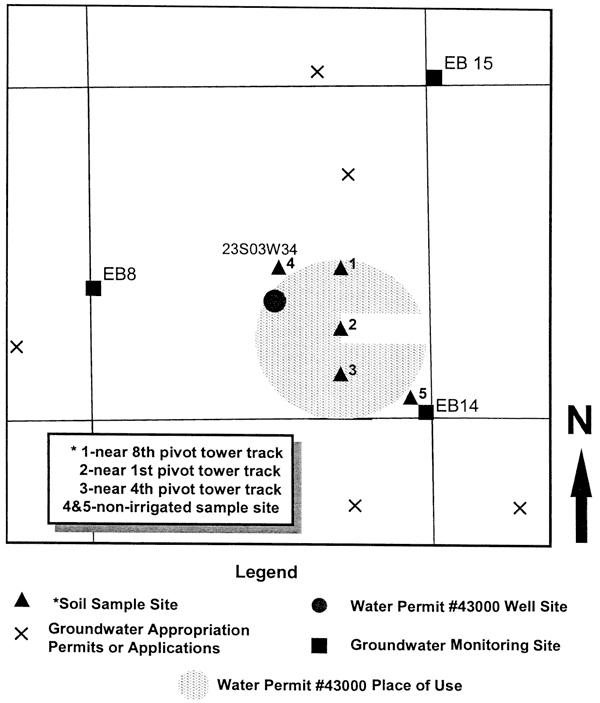
Table 2. Chemical analyses for soils collected within and outside the irrigated land associated with permit #43000 irrigation well located at 23S-03W-34DBC. Sites 1-3 are located within the center pivot irrigation circle and sites 4 and 5 are located outside the irrigation circle in the northwest corner and southeast corner of the quarter section of the circle. Servi-Tech Laboratories analyzed the soil samples based on water extracted from a saturated paste of the soil and reported the values for the dissolved constituents as ppm (mg/L) in the extract solution. The electrical conductivity in μmho/cm is the same as μS/cm.
| Sample depth 0-10 inches | ||||||||||||||||
|---|---|---|---|---|---|---|---|---|---|---|---|---|---|---|---|---|
| Sodium, mg/L | Chloride, mg/L | Sulfate, mg/L | Electrical conductivity, μmho/cm | |||||||||||||
| Site ID | Feb '00 | Dec '00 | Mar '01 | Oct '01 | Feb '00 | Dec '00 | Mar '01 | Oct '01 | Feb '00 | Dec '00 | Mar '01 | Oct '01 | Feb '00 | Dec '00 | Mar '01 | Oct '01 |
| 1 | 89.2 | 147 | -- | 173.8 | 241 | 325 | -- | 461 | 44.9 | 80.9 | -- | 79.1 | 900 | 1200 | -- | 1700 |
| 2 | 95.8 | 115 | -- | 185.4 | 203 | 276 | -- | 587 | 39.2 | 44.9 | -- | 57.2 | 1000 | 1100 | -- | 2200 |
| 3 | 45.8 | 130 | -- | 187.6 | 109 | 350 | -- | 636 | 37.4 | 59.9 | -- | 51.2 | 500 | 1300 | -- | 2200 |
| 4 | 11.1 | 17 | -- | 16.0 | 18.1 | 18 | -- | 20 | 29.4 | 17.4 | -- | 23.1 | 200 | 200 | -- | 300 |
| 5 | 25.8 | 14 | -- | 14.8 | 25.4 | 10 | -- | 15 | 31.5 | 18.3 | -- | 29.4 | 200 | 200 | -- | 400 |
| Sample depth 10-20 inches | ||||||||||||||||
| Sodium, mg/L | Chloride, mg/L | Sulfate, mg/L | Electrical conductivity, μmho/cm | |||||||||||||
| Site ID | Feb '00 | Dec '00 | Mar '01 | Oct '01 | Feb '00 | Dec '00 | Mar '01 | Oct '01 | Feb '00 | Dec '00 | Mar '01 | Oct '01 | Feb '00 | Dec '00 | Mar '01 | Oct '01 |
| 1 | -- | -- | -- | 176.4 | -- | -- | -- | 512 | -- | -- | -- | 48.2 | -- | -- | -- | 1800 |
| 2 | -- | -- | 185.1 | 169.8 | -- | -- | 593 | 606 | -- | -- | 47.3 | 56.0 | -- | -- | 2000 | 2100 |
| 3 | -- | -- | 223.2 | 186.2 | -- | -- | 599 | 622 | -- | -- | 58.7 | 44.3 | -- | -- | 2100 | 2100 |
| 4 | -- | -- | -- | 10.2 | -- | -- | -- | 10 | -- | -- | -- | 16.8 | -- | -- | -- | 200 |
| 5 | -- | -- | 64.0 | 19.3 | -- | -- | 16 | 11 | -- | -- | 29.4 | 19.2 | -- | -- | 400 | 200 |
| Sample depth 20-30 inches | ||||||||||||||||
| Sodium, mg/L | Chloride, mg/L | Sulfate, mg/L | Electrical conductivity, μmho/cm | |||||||||||||
| Site ID | Feb '00 | Dec '00 | Mar '01 | Oct '01 | Feb '00 | Dec '00 | Mar '01 | Oct '01 | Feb '00 | Dec '00 | Mar '01 | Oct '01 | Feb '00 | Dec '00 | Mar '01 | Oct '01 |
| 1 | -- | -- | -- | 185.2 | - - | -- | -- | 475 | -- | -- | -- | 50.9 | -- | -- | -- | 1700 |
| 2 | -- | -- | 260.2 | 162.7 | -- | -- | 653 | 449 | -- | -- | 33.6 | 56.3 | -- | -- | 2200 | 1600 |
| 3 | -- | -- | 298.3 | 211.0 | -- | -- | 433 | 454 | -- | -- | 53.3 | 48.5 | -- | -- | 1900 | 1700 |
| 4 | -- | -- | -- | 11.2 | -- | -- | -- | 10 | -- | -- | -- | 13.5 | -- | -- | -- | 200 |
| 5 | -- | -- | 107.5 | 36.6 | -- | -- | 11 | 14 | -- | -- | 31.8 | 30.0 | -- | -- | 700 | 300 |
The KGS called Servi-Tech Laboratories to obtain the procedure they used for the soil analysis. Servi-Tech first dried about 100-200 grams of soil overnight at 40 °C and then ground the soil. They weighed a portion of the dried soil and added deionized water to prepare a saturated paste. They selected a portion of the dried sample for moisture analysis and dried it overnight at 105 °C. They used the residual moisture content (usually about 5%) to correct the weight of the 40 °C dried sample to the completely dried weight at 105 °C. After letting the saturated paste sit overnight, they added more water if necessary to produce a paste appropriate for further processing. They weighed the saturated paste and then vacuum filtrated the paste to obtain water that they analyzed for electrical conductivity (specific conductance) and dissolved constituent concentrations. They reported the results for dissolved constituents as the concentration in the extract water (ppm on the analysis sheets, which is equivalent to mg/L in the extract solution).
The KGS converted the concentrations of the soluble constituents in the soil extract water to mg of constituent per kg (equivalent to ppm) of dry soil using the water saturation percent of the soil paste that Servi-Tech reported in their analyses (Table 3). The KGS calculated the increase in salt content (chloride concentration) of the upper 30 inches of soil underlying the 130 acre irrigated circle derived from the added irrigation water using the data in Table 3 and the bulk volume of the soil. The average extractable chloride content of the upper 30 inches of the soil within the irrigation circle (sample sites 1-3) based on the October 2001 samples was 264.9 mg/kg. The average background content of extractable chloride in the soil for October 2001 was 6.1 mg/kg. Thus, the average chloride content in the soil added from the applied irrigation water was 258.8 mg/kg. This represented an increase of 42.4 times or 4,240% in the background chloride content of the soil.
Table 3. Chemical data for soils listed in Table 2 converted from mg/L in the soil paste extract to mg/kg (ppm) in dry soil. The water saturation % is the amount of water added to the dry soil sample (corrected for residual moisture) to prepare the soil paste from which the water was extracted for chemical analysis.
| Sample depth 0-10 inches | ||||||||||||||||
|---|---|---|---|---|---|---|---|---|---|---|---|---|---|---|---|---|
| Water saturation % | Sodium, mg/kg | Chloride, mg/kg | Sulfate, mg/kg | |||||||||||||
| Site ID | Feb '00 | Dec '00 | Mar '01 | Oct '01 | Feb '00 | Dec '00 | Mar '01 | Oct '01 | Feb '00 | Dec '00 | Mar '01 | Oct '01 | Feb '00 | Dec '00 | Mar '01 | Oct '01 |
| 1 | 32 | 34 | -- | 37 | 28.5 | 50.0 | -- | 64.3 | 77.1 | 110.5 | -- | 170.6 | 14.4 | 27.5 | -- | 29.3 |
| 2 | 34 | 40 | -- | 46 | 32.6 | 46.0 | -- | 85.3 | 69.0 | 110.4 | -- | 270.0 | 13.3 | 18.0 | -- | 26.3 |
| 3 | 37 | 36 | -- | 43 | 16.9 | 46.8 | -- | 80.7 | 40.3 | 126.0 | -- | 273.5 | 13.8 | 21.6 | -- | 22.0 |
| 4 | 27 | 34 | -- | 44 | 3.0 | 5.8 | -- | 7.0 | 4.9 | 6.1 | -- | 8.8 | 7.9 | 5.9 | -- | 10.2 |
| 5 | 32 | 32 | -- | 41 | 8.3 | 4.5 | -- | 6.1 | 8.1 | 3.2 | -- | 6.2 | 10.1 | 5.9 | -- | 12.1 |
| Sample depth 10-20 inches | ||||||||||||||||
| Water saturation % | Sodium, mg/kg | Chloride, mg/kg | Sulfate, mg/kg | |||||||||||||
| Site ID | Feb '00 | Dec '00 | Mar '01 | Oct '01 | Feb '00 | Dec '00 | Mar '01 | Oct '01 | Feb '00 | Dec '00 | Mar '01 | Oct '01 | Feb '00 | Dec '00 | Mar '01 | Oct '01 |
| 1 | -- | -- | -- | 48 | -- | -- | -- | 84.7 | -- | -- | -- | 245.8 | -- | -- | -- | 23.1 |
| 2 | -- | -- | 52 | 48 | -- | -- | 96.3 | 81.5 | -- | -- | 308.4 | 290.9 | -- | -- | 24.6 | 26.9 |
| 3 | -- | -- | 51 | 50 | -- | -- | 113.8 | 93.1 | -- | -- | 305.5 | 311.0 | -- | -- | 29.9 | 22.2 |
| 4 | -- | -- | -- | 49 | -- | -- | -- | 5.0 | -- | -- | -- | 4.9 | -- | -- | -- | 8.2 |
| 5 | -- | -- | -- | 48 | -- | -- | 28.8 | 9.3 | -- | -- | 7.2 | 5.3 | -- | -- | 13.2 | 9.2 |
| Sample depth 20-30 inches | ||||||||||||||||
| Water saturation % | Sodium, mg/kg | Chloride, mg/kg | Sulfate, mg/kg | |||||||||||||
| Site ID | Feb '00 | Dec '00 | Mar '01 | Oct '01 | Feb '00 | Dec '00 | Mar '01 | Oct '01 | Feb '00 | Dec '00 | Mar '01 | Oct '01 | Feb '00 | Dec '00 | Mar '01 | Oct '01 |
| 1 | -- | -- | -- | 60 | -- | -- | -- | 111.1 | -- | -- | -- | 285.0 | -- | -- | -- | 30.5 |
| 2 | -- | -- | 57 | 56 | -- | -- | 148.3 | 91.1 | -- | -- | 372.2 | 251.4 | -- | -- | 19.2 | 31.5 |
| 3 | -- | -- | 62 | 63 | -- | -- | 184.9 | 132.9 | -- | -- | 268.5 | 286.0 | -- | -- | 33.0 | 30.6 |
| 4 | -- | -- | -- | 48 | -- | -- | -- | 5.4 | -- | -- | -- | 4.8 | -- | -- | -- | 6.5 |
| 5 | -- | -- | 56 | 49 | -- | -- | 60.2 | 17.9 | -- | -- | 6.2 | 6.9 | -- | -- | 17.8 | 14.7 |
The KGS obtained the average bulk density of the soil in the irrigated area from the Natural Resource Conservation Service office in Salina. The average bulk densities of the upper, middle, and lower layers of the Punkin-Kisawa soils in the Burrton area are 1.5, 1.5, and 1.38 kg/103 cm3, respectively, giving an overall average of 1.46 kg/103 cm3. The amount of chloride added to 103 cm3 of soil in the irrigated area is 258.8 mg/L times the bulk density (as kg/103 cm3), equaling 377.8 mg/103 cm3 or 0.3778 kg/m3. The volume of the soil in the irrigated area is 130 acres times the depth of 30 inches, giving 1.416 x 106 ft3 or 4.009 x 10⁵ m3. The weight of the extractable chloride in the soil that was added by the irrigation water is 151,500 kg.
The Division of Water Resources provided the data for the amounts of irrigation water applied in 1999, 2000, and 2001 (87, 107, and 111 acre-ft, respectively, or 107,300, 132,000, and 136,900 m3, respectively). The average chloride concentrations of the irrigation water in 1999, 2000, and 2001 were 703, 735, and 755 mg/L, respectively. The weights of the chloride in the irrigation water in 1999, 2000, and 2001 were 75,430, 97,020, and 103,360 kg, respectively, for a total of 275,800 kg.
Therefore, 55% of the chloride applied in the irrigation water was in the upper 30 inches of soil underlying the 130 acres of irrigated area in October 2001. The other 45% of the chloride dissolved in the applied irrigation water (124,300 kg) was either in the moisture of the unsaturated zone at a depth of more than 30 inches underlying the irrigated area, had leached to the ground-water table, or was removed by runoff or harvesting of grain from the field.
The addition of chloride in fertilizer added to the irrigated area is unknown. If potassium was added in the fertilizer, a possible chloride source could be potassium chloride if potassium sulfate was not the ingredient. Grain grown in the irrigated field would incorporate some chloride from the water. Plants draw up water through a semipermeable membrane in the plant roots and exclude most of the salt dissolved in the soil water. However, some of the salt does enter the plant, including chloride. The average chloride content of crops such as soybeans, corn, and sorghum ranges from about 1 to 7 lbs/acre based on information from Kansas State University. If the upper value of 7 lbs/acre (3 kg/acre) is used, the mass of chloride harvested with the grain on the 130 acres of irrigated land is about 390 kg for one year and 1,170 kg for three years. This is approximately 0.4% of the total chloride added to the land in the irrigation water. In general, the higher the soil moisture salinity, the higher can be the amount of many elements drawn into the plant in the water. Even if the chloride content of the crops irrigated with the saline ground water were two or three times the usual average, the total chloride removed in the crops harvested would be less than 2% of the chloride added in the irrigation water. Thus, the amount of chloride removed in the grain would be within the analytical error range for the chloride determinations in the irrigation water and soil solution extract.
It is assumed that the land is relatively flat and that little surface runoff occurs during rainstorms. If significant runoff did occur, then some chloride could have been removed from the soil and could have increased the chloride concentration of surface water draining from the area. However, this would be expected to affect the chloride accumulated in only the upper few inches of the soil.
The depth to the static ground-water level just to the east-southeast of the irrigated circle was 16 ft in May 1999 based on the log for the domestic well in the NE/4 SE/4 SE/4 Sec. 34, T. 23 S., R. 3 W. installed for John Gray. The depth to water on the west side of the irrigation circle was 12 ft in July 1999 based on the log for the irrigation well (permit #43000) drilled for John Gray in the SW/4 NW/4 SE/4 Sec. 34, T. 23 S., R. 3 W. Other well logs in Sec. 34 indicate that the water level ranges from 12-20 ft below land surface (bls).
If 5% of the chloride added to the field in the irrigation water is assumed to be removed by surface runoff and crop harvest, then the total remaining chloride added during 1999-2001 that is not accounted for in the soil of the irrigated field is 110,500 kg. If all of this chloride were distributed throughout the unsaturated zone below the soil to an average water-table depth of 14 ft, the average increase in the chloride content would be about 41 mg/kg in the 11.5 ft between the 30-inch soil depth and the water table. If the background chloride in the unsaturated zone were similar to that in the upper 30 inches of soil, this would represent an increase of 6.7 times or 670% 111 the chloride content.
The amount of chloride that has already reached the water table of the Equus Beds aquifer depends on the amount of leachate water that seeped below the 30 inches of the soil and the permeability of the unsaturated zone. If leachate reached the water table, the amount of ground water affected would depend on the characteristics of the aquifer and the ground-water flow rate, as well as the amount of leachate water. Well logs for Sec. 34 in which the irrigation well is located generally indicate that clay to silty clay exists below the soil to a depth of about 712 ft bls. Many of the well logs in the southern half of Sec. 34 indicate that a fine to coarse sand or sand and gravel extends from below the clay to a depth of 39-45 ft bls, and that a 2-7 ft thick clay occurs below this sand and gravel interval. However, this clay was not recorded at the location of the Gray irrigation well in the SW/4 NW/4 SE/4 of Sec. 34. A 1-2 ft thick clay exists in the shallow sands and gravels according to most of the well logs. A one-ft thick clay at 30-31 ft is the only clay layer in the sand interval from 12 to 105 ft recorded in the Gray irrigation well log. The screened interval (30-40 ft) of the shallow well at monitoring site EB14 of GMD2 (Figure 1) is at the bottom of the shallow aquifer.
These lithologic logs generally indicate that that there is a shallow zone of permeable sediments within the Equus Beds aquifer (termed the upper or A zone by GMD2) in the area of the irrigated circle with a thickness of about 30 ft that is overlain by approximately 10 ft of soil and clay to silty clay, and underlain by a discontinuous clay zone. If the average depth to the water table underlying the irrigated field is 14 ft, then the saturated thickness of the shallow aquifer zone is approximately 26 ft. The full 30 ft of the shallow aquifer could be saturated during wet periods whereas less than 26 ft could be saturated during droughts. If the drawdown in the middle zone of the aquifer caused by pumping of the irrigation well were transmitted to the shallow aquifer, the saturated thickness could be smaller during the irrigation season.
Estimates of the amount of saline leachate that has or will reach the water table depend on assumptions of how rapidly and uniformly the moisture moves through the unsaturated zone. One end-member assumption is a uniform movement of leachate through the clayey portion of the unsaturated zone, which raises the extractable chloride content of the sediment to the level observed at the end of 2001 in the 30-inch topsoil before any leachate enters the ground water. Once the leachate reached the top of the sandy aquifer sediments, it would be expected to drain at a much faster rate to the water table. The amount of chloride in the irrigation water applied during 1999-2001 not accounted for in the topsoil and adjusted for a 5% loss to runoff and grain harvest is 110,500 kg. This gives an average addition rate of 36,800 kg/year. If the average depth of the bottom of the shallow clayey zone is 10 ft, there is about 7.5 ft of unsaturated fine-grained sediments below the 30-in topsoil. If the average addition rate of irrigation water chloride remained the same, it would take roughly an additional 9 years to raise the chloride content of this clayey zone to the same concentration increase of 258.8 mg/kg as observed in the topsoil. Then substantial chloride contents would break through and drain to the ground-water table. A problem with this end-member assumption is that the recharge rate through the unsaturated zone could only be on the order of about one inch per year to keep the leachate from penetrating through the unsaturated zone during 12 years. This is a much lower value than expected for recharge below an irrigated field in Equus Beds area. A faster recharge rate would carry the chloride more rapidly to the water table because dissolved chloride would not be removed from the seepage water by reactions with the sediment. In addition, sediments are typically heterogeneous and can allow preferential pathways of flow.
An alternative, more realistic assumption is that some of the leachate reaches the water table through preferential pathways and the rest slowly raises the salt content of the bulk of the unsaturated zone sediment. If 10% of the chloride applied in the irrigation water that had penetrated below 30 inches had reached the water table by October 2001 and mixed uniformly in the upper 10-ft of ground water immediately underlying the water table, the chloride concentration would have been elevated by about 57 mg/L, assuming an effective porosity (water volume affected by the increase in chloride content) of 30% in the aquifer. If this same amount of chloride had dispersed evenly into a 26-ft saturated thickness of the shallow aquifer zone, the chloride content of the ground water would have been increased by approximately 22 mg/L.
As additional amounts of irrigation water are applied and the saline soil moisture continues to leach below the root depth, the salinity of the water in the unsaturated zone below the root zone will continue to increase. This will increase the concentration and mass of the dissolved salts reaching the water table. Eventually, the rate of chloride added by irrigation water to the soil will be approximately balanced by the rate of chloride leached from the soil to the water table. If 5% of the chloride added to the field in the irrigation water is assumed to have been removed by surface runoff and crop harvest, then the annual chloride addition to the soil of the irrigated field is 87,300 kg (based on an average of the three years of irrigation water data). Assuming that this amount will eventually leach annually to the water table, the increase in chloride concentration in a 10-ft zone of ground water underlying the field would be 218 mg/L. If the chloride affected a 20-ft thick zone, then the increase in chloride concentration would be about half of 218 mg/L. However, the increase in the ground-water salinity would be expected to be greater immediately underlying the water table than deeper in the saturated zone.
The increase in the chloride content of the ground water would not be expected to be a simple multiple of the amount added each year because the volumes of the leachate and existing ground water that mix need to be considered in the calculation. The leachate volume could range substantially each year depending on the amount of rainfall, evapotranspiration, and irrigation water applied. The location of the site is in an area of Kansas where the long-term potential evapotranspiration and precipitation are roughly equal. The long-term average leachate volume reaching the water table under the irrigated field should be substantially greater than the few to several inches of average annual recharge over non-irrigated areas and less than the sum of this recharge and the amount of irrigation water. A long-term average leachate volume reaching the water table that was substantially less than the amount of irrigation water, which would represent conditions of net evapotranspiration loss, would mean that the applied salt load would be dissolved in a smaller volume of water than used for irrigation. This condition could allow the maximum chloride content of the ground water underlying the circle to approach a value somewhat greater than that of the applied irrigation water. An average leachate volume equal to the sum of the irrigation water applied and the average regional recharge from precipitation in unirrigated areas would mean that the applied salt load would be dissolved in a larger volume of water than used for irrigation. This could result in a maximum chloride concentration of the ground water less than that of the irrigation water.
Another factor controlling the impact of the leachate on the ground-water salinity under the irrigated field is the flow of ground water underlying the field area. The flow would move shallow ground water from upgradient and outside the irrigated circle to under the field, and move saline ground water under the field impacted by the leachate to outside the circle. Although the pumping by the irrigation well would somewhat affect the local, shallow groundwater flow rates, the subregional flow rate in the area can be roughly estimated from the subregional topographic gradient and typical aquifer parameters. The topographic gradient in a circle of a few miles radius in the area is approximately 5 ft/mile. Using a hydraulic conductivity of 150 ft/day and a porosity of 30% gives an average linear velocity of ground-water flow of 0.5 ft/day or 182 ft/year. The fraction of the ground-water moving from under to outside the irrigation circle area each year as a result of regional flow would be a little greater than the ratio of the linear ground-water velocity to the circle diameter based on geometry and mechanical dispersion. Thus, approximately 7-10% of the shallow saline ground water impacted by leachate might move outside of the area immediately underlying the irrigation circle each year based on this estimated flow velocity. Preferential flow in the aquifer and variations in the flow velocity could result in smaller or larger percentages of contaminated water moving from the circle area.
As estimated earlier, if 10% of the chloride added by the irrigation water during 1999-2001 had leached to the water table and completely mixed in a 26-ft thick shallow aquifer to a depth of 40 ft, the chloride concentration of the ground water underlying the irrigated circle would have been increased by about 22 mg/L over the background concentration. The distance from the perimeter of the irrigation circle to the southeast corner of Sec. 34 is 547 ft based on a geometrical calculation. There are two monitoring wells owned and sampled by GMD2 in the southeast corner of Sec. 34 (Site EB14, Figure 1). Assuming that the monitoring well site is 100-200 feet northwest of the section corner, the lateral distance from the edge of the irrigated field to the monitoring wells is about 350-450 ft. This distance would be smaller if end guns were used in the circle. At an average linear velocity of ground-water flow of 182 ft/yr, it would take about two years for aquifer water affected by saline leachate from the irrigated field to reach the shallow monitoring well (EB14A) that is screened at a depth of 30-40 ft bls. Except for one sample, the chloride concentration observed in waters collected from this well has ranged between 19 and 43 mg/L during 1980-2000. The exception was 1993, when the chloride content observed was 76 mg/L. The average chloride concentration for 1980-2000 was 31 mg/L with and 29 mg/L without the 1993 sample. The chloride concentration measured by GMD2 for September 2001 was 49 mg/L. An increase of 22 mg/L chloride content in the 26-ft thick shallow aquifer at the edge of the irrigated field would have resulted in a chloride value of about 50-60 mg/L, assuming that the background chloride was about that observed for EB14A during 1994-2000. This concentration would be expected to decrease somewhat during flow towards the EB14 well site due to dispersion in the aquifer water containing a chloride level less than 44 mg/L. The 49-mg/L chloride measured in the 2001 sample from EB14A could possibly represent the effect of the leachate water. However, additional monitoring will be necessary to conclusively determine when substantial leachate chloride reaches the location of EB14A.
The chloride content of the leachate water reaching the water table below the irrigated circle could eventually increase to close to the concentration in the irrigation water. The long-term impact of the leachate on the chloride concentration in the ground water underlying the irrigated field will depend largely on how deep is the mixing zone of the leachate and ground water. A vertical decrease in the chloride concentration of the ground water could be expected under the water table extending down to the first locally continuous clay layer of substantial thickness. Lateral ground-water flow within the shallow part of the aquifer above the clay layer would be expected to move the impacted ground water much faster away from the irrigated circle than vertical flow through the clay layer. Leachate on the upgradient ground-water flow side of the irrigation circle will have more time to disperse deeper into the shallow aquifer than that on the downgradient side, especially if there is little clay in the zone about 40 ft bls.
Based on the above estimates, it will probably take a few more years before the saline leachate substantially increases the chloride concentration of the ground water in the shallow aquifer at the EB14A and the Gray domestic well locations. In about the same time frame, the slow migration of the oil-brine plume causing the salinity increase in the shallow aquifer observed at monitoring well EB8A a half mile west of the irrigation circle may reach the western part of the aquifer underlying the circle. The mixing of the plume chloride with the irrigation circle leachate will further elevate the shallow ground-water salinity. Determination of the impact of the leachate relative to that of the subregional movement of the contamination plume from the west could be difficult. The rate of increase of the chloride concentration at EB14A compared to that at EBSA will give an indication of the relative leachate effect.
The average extractable sulfate content of the top 30 inches of soil under the irrigated area was 26.9 mg/kg in comparison with 10.1 mg/kg in the soils from the non-irrigated area in October 2001. This gives an increase of 16.8 mg/kg derived from the application of the irrigation water. The mass ratio of the sulfate/chloride concentration increase in the irrigated soil was 0.065 in comparison with the average ratio of 0.069 in the irrigation water. The difference in these ratios is within the possible errors in water and soil sample analyses and in the representativeness of the samples. Thus, the rate of increase in the sulfate content in the extractable soil water is consistent with the chloride addition from the irrigation water. The sulfate content of fresh ground water in the Equus Beds area aquifer is generally less than the 45-57 mg/L observed in the permit #43000 irrigation water but ranges up to about the same concentration. In general, the direct impact of the saline irrigation water on sulfate concentration of the shallow aquifer will be minimal. An analysis of groundwater from the EB14A location for sulfate content would be needed for a good comparison of the difference in the irrigation water and the shallow aquifer in the area.
Another impact of the saline irrigation water on the quality of the ground water in the shallow aquifer will be an increase in the hardness. The predominant effect would be caused by the higher calcium and magnesium contents of the irrigation water in comparison with fresh aquifer water. Cation exchange in soils caused by addition of sodium in saline waters can increase calcium and magnesium concentrations in soil and aquifer waters. The sodium/chloride mass ratio of the oil brine that caused the saltwater contamination of the Equus Beds aquifer in the Burrton area was greater than the average ratio of 0.275 observed in the permit #43000 irrigation water. Exchange of calcium and magnesium for sodium on clays in the soils and the aquifer sediments from past infiltration of oil brine disposed at the surface decreased the sodium content and increased the calcium and magnesium concentrations during pollution of the ground water.
The ratio of the extractable sodium/chloride added to the top 30 inches of soil by the irrigation water was 0.321 in October 2001. Thus, the sodium/chloride ratio increased somewhat in the soil extract relative to the ratio for the irrigation water. This observation and the sodium adsorption ratio of the irrigation water indicate that there will probably not be a sodium hazard to the soils caused by the saline water application. Thus, gypsum would probably not be needed as a soil amendment. If gypsum were added, it would cause additional increases in the calcium and sulfate contents of the soil leachate and eventually, in the ground water underlying the irrigated area.
The application of saline ground water for irrigation under permit #43000 in western Harvey County has substantially increased the extractable chloride content of the top 30 inches of soil in the irrigated area. The average chloride concentration of the irrigation water during 1999-2001 was 731 mg/L. The average chloride content in water extracts of soil samples collected in October 2001 underlying the irrigated area was 534 mg/L in comparison with 13 mg/L for soils outside the irrigated area. The difference in the mass of chloride extractable from the irrigated and non-irrigated soils is equivalent to 55% of the chloride mass in the irrigation water applied to the land. Thus, 45% of the chloride mass in the applied irrigation water is not accounted for in the top 30 inches of the soil. The total chloride removed in the grain harvested from the field probably is less than 2% of the chloride in the applied irrigation water. Little of the chloride has probably been removed by runoff during rainstorms due to the flat topography of the land. At least about 40% of the chloride mass in the applied irrigation water is expected to be in the unsaturated zone and the shallow ground water underlying and just downgradient of the irrigated field.
The shallow permeable sediments in the evaluation area extend from a depth of about 10 ft below land surface down to a discontinuous clay unit at a depth of about 40 ft. If the average water-table depth is approximately 14 ft, the saturated thickness of the shallow or upper zone of the Equus Beds aquifer is about 26 ft in the area of the irrigation circle in Sec. 34. If as much as 10% of the chloride content in the applied irrigation water has already leached to the ground water and completely mixed in the shallow aquifer to a depth of 40 ft underlying the irrigated field, the chloride concentration would have been raised by approximately 22 mg/L over the background concentration. Dispersion of this chloride concentration during downgradient ground-water flow would make discernment of the possible impact of leachate from the irrigated field difficult at this time.
Continued application of the saline irrigation water can be expected to eventually increase the chloride content of moisture in the unsaturated zone to nearer that of the irrigation water, resulting in substantially increasing the chloride content of the underlying ground water in the shallow aquifer. The time for this increase to occur and be easily observed in the shallow aquifer at the domestic well to the east and the EB14A monitoring well to the southeast of the irrigation circle could be a few to several years after 2001.
Kansas Geological Survey, Geohydrology
Placed online Aug. 29, 2007, original report dated May 2002
Comments to webadmin@kgs.ku.edu
The URL for this page is http://www.kgs.ku.edu/Hydro/Publications/2002/OFR02_24/index.html