Kansas Geological Survey, Open-file Report 93-47
KGS Open File Report 93-47
A Cooperative Investigation by the Kansas Geological Survey, Equus Beds Groundwater Management District No. 2, and Wichita-Sedgwick County Department of Community Health
December 1993
A study was conducted by the Kansas Geological Survey, the Equus Beds Groundwater Management District No. 2, and the Wichita-Sedgwick County Department of Community Health to assess the impact on ground-water quality in the Equus Beds aquifer of stormwater recharge from unlined earthen pits. Two sites were examined, both of which are located at or near the north boundary of Wichita and south of Valley Center. One site, Fox Meadows, drains a new residential area, and the other, Miles Sand, drains a more urban area that includes heavily traveled Meridian Street. The investigation provides background data against which to compare future effects of infiltrating storm runoff in the developing area.
Surface waters in the stormwater retention pits and a drainage ditch to the Miles Sand pit and ground waters underlying the pit areas did not contain volatile organic compounds, triazine herbicides, or heavy metals in concentrations of concern to water supplies. One of the drainage ditch samples contained detectable insecticide chemicals. Agricultural activities occurring before the new housing development in Fox Meadows appear to have caused nitrate contamination of the Equus Beds aquifer there (about 4-8 mg/L nitrate-nitrogen), although the values are less than the drinking-water standard. Nitrate concentrations in all the other surface and ground waters sampled were relatively low (0.3 to less than 3 mg/L nitrate-nitrogen).
The main water-quality problem is saline water (490-580 mg/L chloride concentration) in the pond and ground waters of Miles Sand. Hydrogeochemical data suggest that most but not all of the salinity is natural. An appreciable portion of the salinity is probably saline water from the Arkansas River and adjacent alluvial aquifer that has flowed in the subsurface toward the Little Arkansas River. Upward movement of saltwater from the Permian Wellington aquifer underlying the study area could possibly contribute to the salinity. Contamination by oil-field brine does not appear to be a significant chloride source. Street runoff containing dissolved road salt applied to streets in the watershed would be the most likely anthropogenic salinity source. The lack of samples collected from the drainage ditch near the pit during the winter makes it difficult to assess whether street runoff is a major source of the salinity.
In 1988 several water users contacted the Equus Beds Groundwater Management District No.2 (GMD2) regarding a stormwater retention pond being constructed in a proposed housing addition north of Wichita. Their concerns included the potential adverse impact of storm water infiltration on ground-water quality, To address the concerns, the GMD2 worked with the Kansas Geological Survey (KGS) and the Wichita-Sedgwick County Department of Community Health (WSCDCH) to develop a memorandum of understanding to determine what effect disposing untreated urban storm water runoff in unlined earthen pits has on the water quality of the Equus Beds aquifer. Accordingly, the KGS, GMD2, and WSCDCH conducted a study involving sampling and analysis of surface and ground waters collected from 1991 to 1992. Two sites were examined, both of which are located at or near the north boundary of Wichita and south of Valley Center between the Arkansas and Little Arkansas rivers. Both sites contain ponds that receive untreated stormwater runoff that either infiltrates to the subsurface or evaporates.
The stormwater retention pond that initiated the ground-water quality concerns is located in a housing development known as Fox Meadows. The housing addition is located in the northern half of NE sec. 13, T. 26 S., R. 1 W. (Figure 1). The area of the housing addition is approximately 60 acres and is subdivided into 60 lots of about 0.5 acre each. Each home requires a domestic well and a septic system.
A stormwater retention pond was constructed in the Fox Meadows development to receive drainage by means of grassed channels and ditches from only the area of the housing development. The retention pond contains a variable amount of water, depending on preceding precipitation, and can be dry after extended periods without substantial precipitation. The retention area is located near the center of the south half of the development and is shown in Figure 1. The pond is about 14 ft (4.3 m) deep and provides about 36 acre-ft of water storage. Sands of the aquifer underlie the soils that were excavated during pond construction, facilitating infiltration of retention water to the underlying aquifer. Water levels measured by the GMD2 indicate that the depth to the water table ranges from 14 to 20 ft (4.3-6.1 m). The retention pond is about 0.5 mi (0.8 km) to the southwest of a bend in the Little Arkansas River and approximately 1 mi (1.6 km) northeast of the Arkansas River. Two irrigation wells and an estimated 20 domestic wells exist within a 0.5-mi radius and downgradient of the retention pond. Only a few houses had been built at the start of the study, and development was continuing at the time of this report.
Figure 1--Map of the study area with locations of storm water retention pits, monitoring and test wells and the drainage ditch sampling point. Small circles indicate monitoring wells (EB), test holes (T), or domestic well (D).
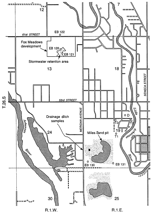
The other site is a pond at Miles Sand Co. in the SW sec. 19, T. 26 S., R. 1 W. (Figure 1), where a pit produced from sand and gravel mining receives untreated stormwater runoff from a much larger area than that of Fox Meadows. The sand pit was excavated by suction-pump mining to the bottom of the alluvial sand and gravel [about 49 ft (15 m) as indicated by the shale depth in the EB 130C well log; see Appendix B]. The watershed draining to the Miles Sand pit encompasses a more urbanized area than the Fox Meadows basin and thus receives runoff from more heavily traveled streets. The level of water in the pit about 15 ft (4.6 m) below land surface indicates the shallow depth to the water table. The pit is about 1.5 mi (2.4 km) to the south-southeast of the Fox Meadows pond, 0.2 mi (0.3 km) west of the Little Arkansas River, and 0.8 mi (1.3 km) northeast of the Arkansas River.
In cooperation with the City of Wichita Water Department, the GMD2 installed three monitoring wells in the Equus Beds aquifer around each of the two stormwater disposal pits (Figure 1). All observation wells were augered and constructed using appropriate quality control procedures and materials to prevent contamination or corruption of water samples from well construction or materials. Two of the wells, EB 120C and EB 121A, in the Fox Meadows area are at two sides of the retention pond, and the other well, EB 122A, is to the north across 61st Street from the housing addition. The three wells near the Miles Sand pit are at two sites, EB 130 and EB 131, to the southwest and the southeast of the sand pit, respectively. Two of the wells at each site are shallow, with depths of 28.5-30 ft (8.7-9.1 m) and are labeled "A" after the well site number. The other well at each site is deeper [49.5 ft (15.1 m)] and is labeled "C". The screened interval in the wells is 5 ft (1.5 m) at the bottom of the borehole. The well casing and continuous-slot screen are PVC. Bentonite was used to grout the well above a gravel pack. Surveyed location and elevation for the wells are listed in Appendix A, and well log and construction information is listed in Appendix B.
Water samples were collected by the WSCDCH according to EPA sampling protocol and sent to the KGS for measurement of dissolved inorganic constituents and to GTEL Environmental Laboratories Inc. in Wichita for determination of volatile organic compounds and selected herbicides. The sampling sites included the six observation wells, the two stormwater recharge pits, a road ditch routing drainage to the Miles Sand pit, and snow melt in a roadside puddle. The road ditch is along the west side of Meridian Avenue and drains through a culvert under the street to the Miles Sand pit. The period of sampling was from August 8, 1991, to July 7, 1992. Sample collection information is summarized in Table 1 and is from sampling logs on file at the WSCDCH and KGS.
To read this report, you will need the Acrobat PDF Reader, available free from Adobe.
Kansas Geological Survey, Geohydrology
Placed online May 12, 2015; originally released Dec. 1993
Comments to webadmin@kgs.ku.edu
The URL for this page is http://www.kgs.ku.edu/Hydro/Publications/1993/OFR93_47/index.html