Kansas Geological Survey, Open-file Report 92-6
KGS Open File Report 92-6
Released 1992
To read this report, you will need the Acrobat PDF Reader, available free from Adobe.
Many regions of western and central Kansas have experienced significant ground-water and streamflow declines, especially during the last two decades (Sophocleous, 1981; Sophocleous and McAllister, 1987, 1990; among others). According to the Kansas Water Office (KWO), extensive ground-water appropriations in the Big Bend Prairie have contributed to extreme low flows in the Arkansas River and Rattlesnake Creek (Water Research Needs Conference, Wichita, Nov. 14, 1984). Also, according to the Kansas Department of Wildlife and Parks, fish and wildlife resources in and along the Arkansas River, the Smoky Hill River, the Pawnee River, Rattlesnake Creek, and other streams in western and south-central Kansas have been significantly affected because of losses of base flows (Water Research Needs Conference, Wichita, Kansas, Nov. 14, 1984).
In 1983 the Kansas legislature passed the minimum instream flow law, which requires that minimum desirable streamflows be maintained in different streams in Kansas, including the Rattlesnake Creek. According to the Kansas Water Plan document (Kansas Water Plan, subsection: Minimum Desirable Streamflows, FY1990; KWO, July 1988): "The safe yield policy of Groundwater Management District No. 5 has not protected low flows in the [Rattlesnake] Creek." Implementation of this law certainly requires a better understanding of the stream-aquifer system. According to the Division of Water Resources (Water Research Needs Conference, Wichita, Kansas, Nov. 14, 1984), a more thorough understanding of this stream-aquifer relationship would allow quantitative determination of the effect of ground-water withdrawals on streamflows and would be valuable in the administration of the minimum desirable streamflow program.
The two major central Kansas wetlands--the Cheyenne Bottoms Wildlife Area and the Quivira National Wildlife Refuge, both of which are classified as "outstanding natural resource areas of unique significance" [KAR 28-16c(3)]--are being threatened because of decreasing water supplies and deteriorating water quality. The quality of ground and surface waters is deteriorating mainly because of increased natural nonpoint mineral intrusion from underlying geologic formations; this increased mineral intrusion is considered to be a consequence of freshwater declines in the Quaternary alluvial aquifers of central Kansas. Natural conditions, such as low streamflows and mineral intrusion, result in violations of the dissolved oxygen, chloride, fluoride, and metals criteria for streams during the summer months in several parts of Kansas. According to Fromm and Wilk (1988), streams in central Kansas overlying the Permian red beds and Wellington formation have elevated levels of metals and selenium. In addition to natural conditions, past and current oil and gas production activities have increased the mineral content of some streams. According to the same report (Fromm and Wilk, 1988), the monitoring station on Rattlesnake Creek at Raymond indicates that the 35.4 river miles of the creek governed by that monitoring station are threatened because of the high concentrations of fecal coliform and salt, which are due to agricultural non-point-source pollution and natural saltwater intrusion.
The Quivira National Wildlife Refuge, which covers approximately 21,280 acres in northeast Stafford County, is a major stopover point for migratory birds in the Central Flyway. The refuge was established in 1955 and obtained a permit to divert 22,000 acre-ft of water per year from Rattlesnake Creek. A review of existing water rights in the Rattlesnake Creek basin as of December 31, 1966 (Stramel, 1967), indicated that more water rights had already been filed in the basin than there was water in the stream, and the applications for irrigation rights were increasing. According to Stramel (1967):
"Development of groundwater in Rattlesnake Creek basin will theoretically, in time, reduce the Creek to a wet weather stream. This results because ground water that normally flows to Rattlesnake Creek will be intercepted by pumping and the base flow of the stream will be intercepted.... Irrigators have already decided to develop the groundwater, and much additional irrigation is expected.... It will be impossible to fully develop the groundwater resources of Rattlesnake Creek basin and not dry up the baseflow of the Creek .... Thus, the drying of Rattlesnake Creek is inevitable. You simply cannot have one without the other."
However, the Rattlesnake Creek is the lifeblood of the Quivira National Wildlife Refuge, a critical habitat for several endangered species of birds and, as mentioned, a major stopover point for thousands of migratory birds. Any major changes in the quantity or quality of river flow can upset the delicate balance necessary for the survival of the Quivira ecological system. Furthermore, a Rattlesnake Creek fish investigation by the Kansas Department of Wildlife and Parks (Ray and Coslett, 1972) concluded that
" ... inadequate flow appears to be the most important limiting factor in establishing and maintaining a sport fishery in Rattlesnake Creek.... If the Rattlesnake Creek sport fishery is to survive, effective legislation restricting present use and limiting further exploitation of ground-water supplies within the basin must be enacted. A detailed ground-water and hydrologic study is needed to provide information upon which the design of a balanced water-use schedule can be developed so that adequate stream flow is insured."
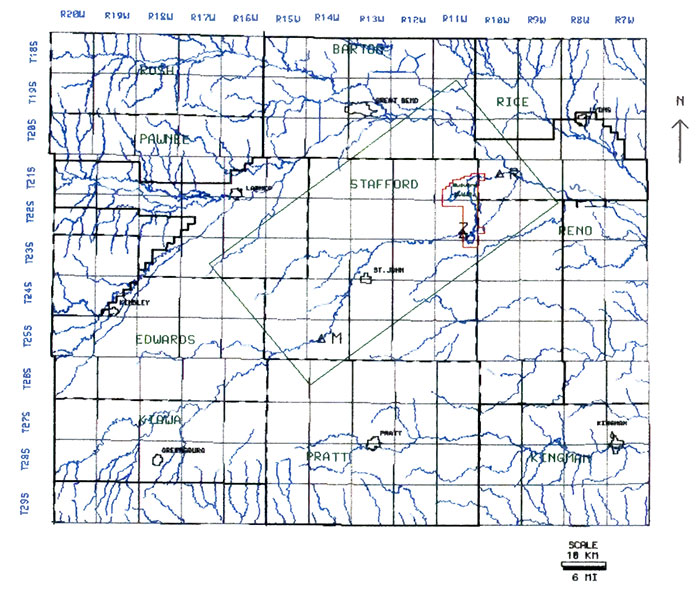
This study was undertaken to address some of these water issues affecting the Quivira National Wildlife Refuge. The study area encompasses an approximately 560 square mile area of the lower Rattlesnake Creek watershed predominantly in Stafford County but also includes portions of other counties, such as Pawnee, Barton, Rice, and Reno (fig. 1). The study area encompasses all three existing stream-gaging stations on the Rattlesnake Creek, namely, the Macksville, Zenith, and Raymond stations.
Figure 1--Study area.
This report is organized into six parts: (1) purpose and objectives, (2) brief hydrogeology of the study region, (3) methodology employed and basic data analysis, (4) model implementation and calibration, (5) numerical modeling results and related analyses, and (6) management alternatives to be tested and other work ahead. The more technical, mathematical parts of section N can be skipped without a loss of continuity.
Kansas Geological Survey, Geohydrology
Placed online Feb. 18, 2016; originally released 1992
Comments to webadmin@kgs.ku.edu
The URL for this page is http://www.kgs.ku.edu/Hydro/Publications/1992/OFR92_6/index.html