Kansas Geological Survey, Open-file Report 92-44
KGS Open File Report 92-44
Released 1992
To read this report, you will need the Acrobat PDF Reader, available free from Adobe.
The Great Bend Prairie aquifer is the primary source of fresh water in the Big Bend Groundwater Management District (GMD5). Water quality in portions of this alluvial aquifer is threatened by salt-water intrusion from underlying bedrock of Permian age. As part of the Mineral Intrusion Study, this report describes Permian bedrock formations in the study area, their hydrologic relation to the overlying aquifer, and the mechanisms for mineral (or salt-water) intrusion.
East of a line roughly coincident with U.S. Highway 281, Permian bedrock directly underlies the Great Bend Prairie aquifer. Highly mineralized waters from the Permian formations discharge into the fresh-water aquifer in this area. Ground-water quality generally deteriorates east of U.S. 281.
The Permian formations in the study area are known to contain salt water. Permian bedrock units include the Cedar Hills Sandstone, the Salt Plain Formation, and the Harper Sandstone. Below these units are the Stone Corral Formation and the Ninnescah Shale. In some locations, Permian hydraulic heads are higher than overlying fresh-water heads, a condition that favors upward leakage of salt water. At certain sites, there is evidence that Permian heads have become higher than deep alluvial aquifer heads for increasingly longer periods as pumping reduces fresh-water heads. The implication is that Permian waters may have an increasing tendency to intrude into the fresh-water aquifer.
Little information is available on the hydrogeologic properties of the Permian formations. Estimates of hydraulic conductivity have ranged from about 0.006 to 14.7 feet per day. Estimates of salt-water discharge from the Cedar Hills Sandstone to the fresh-water aquifer have been roughly 700 to 14,000 acre-feet per year. Due to lack of detailed knowledge about aquifer hydrogeologic properties and hydraulic relationships, a precise estimate of total leakage from Permian bedrock can not be made at this time. Features such as clay lenses, fractures, and unplugged wells and boreholes further complicate the salt-water movement.
Based on an estimated partial water budget for the aquifer area in contact with the Cedar Hills formation, the amount of water entering the Great Bend Prairie aquifer from the bedrock may be of the same magnitude as that entering as recharge from precipitation. This suggests that under natural conditions there may be a dynamic balance between these two sources of recharge to the Great Bend Prairie aquifer. Mineral intrusion may therefore be a serious threat to the water quality of the fresh-water aquifer in the area if ground-water withdrawals disrupt the balance of recharge sources.
The Cedar Hills Sandstone and other shallow formations have been used for oil-field brine disposal. Ground-water contamination from oil-field brines has been confirmed at at least one site in the study area, and at others to the west. Disposal may also have altered the hydraulic heads, and hence the discharge distribution, of the Cedar Hills formation relative to the Great Bend Prairie aquifer.
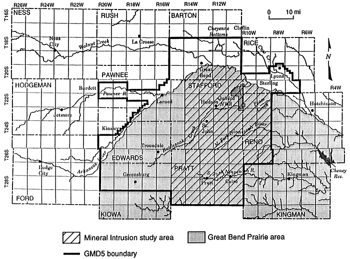
The Great Bend Prairie aquifer is the primary source of fresh water in the Big Bend Groundwater Management District (GMD5). The water quality of part of this alluvial aquifer is threatened by mineral intrusion from underlying bedrock of Permian age, which contains ancient brines. Mineral (or salt-water) intrusion is a natural process in the eastern portion of GMD5, but its rate and extent can be altered by human activities. Leakage of salt water from bedrock already has rendered ground water unusable for most purposes in parts of eastern GMD5. This report describes the Permian bedrock formations in the study area (Figure l), their hydrologic relation to the overlying aquifer, and the mechanisms for salt-water intrusion. A companion report (Whittemore, 1993) discusses the geochemistry of ground waters in the study area.
Figure 1--Map of the Big Bend Groundwater Management District (GMD5) showing the major features of the region and the area of primary interest to this study.
Kansas Geological Survey, Geohydrology
Placed online Feb. 16, 2016; originally released 1992
Comments to webadmin@kgs.ku.edu
The URL for this page is http://www.kgs.ku.edu/Hydro/Publications/1992/OFR92_44/index.html