Kansas Geological Survey, Open-file Report 92-25
KGS Open File Report 92-25
Released September, 1992
To read this report, you will need the Acrobat PDF Reader, available free from Adobe.
In the eastern portion of Groundwater Management District No. 5, a brine-containing formation underlies and is connected with the Great Bend Prairie aquifer, the primary source of freshwater in the area. Concerns about water table declines and decreasing stream flow in this area are intensified by the possibility that freshwater withdrawals will increase the rate of saltwater intrusion and reduction of water quality. The Kansas Water Office has funded a major study by the Kansas Geological Survey to describe the natural process of mineral intrusion and to determine how these processes might be altered by human-induced changes in the water budget of the area. The expected results include descriptions and models that can be used by water planning and management agencies to address issues such as the safe yield of the aquifer under various conditions.
Proposed research includes field studies to determine the geohydrologic characteristics of the brine-containing formation and freshwater aquifer, regional characteristics of the saltwater-freshwater interface and its variation over time, and the extent of local salt-water upconing that may result from high-volume pumping. Vertical models of the salt-water interface and its response to water table changes, and larger-scale models of the water and salt budgets for the entire area will be developed and calibrated against existing data. A system of management, technical advisory, and public information and advisory committees will be established to ensure that the research approach is of the highest possible quality and responsive to local needs.
This report describes the background, issues, and objectives of the Mineral Intrusion Study, a research project undertaken by the Kansas Geological Survey (KGS) with funding from the Kansas Water Office (KWO). The purpose of this report is to provide information for other agencies and the interested public to facilitate both effective interagency coordination and an improved general understanding of the water resource issues of south-central Kansas.
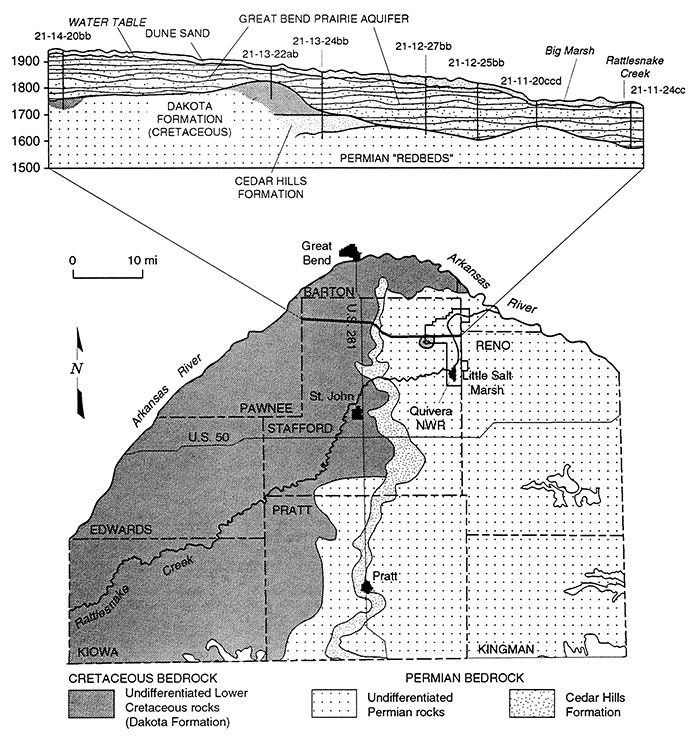
The focus of the study is the present and possible future contamination of fresh groundwater resources by natural saltwater in the eastern portions of Groundwater Management District No. 5 (GMD5), shown in Figure 1. South of the Arkansas River and east of US-281, there is no effective separation of the Great Bend Prairie aquifer from the underlying Permian "red beds" that contain ancient brines (Figure 2). Saltwater is therefore free to move upward into the freshwater aquifer. There is concern that withdrawal of fresh water and lowering of the water table may reduce the confining pressure of the freshwater head and increase the flow of saltwater into the Great Bend Prairie aquifer. In addition, intensive local pumping may cause vertical mixing of the saltwater even in areas where there is no long-term net decline in the water table. Although we have no detailed knowledge of the geographic extent or rate of salt intrusion at present, increasing salt concentrations in some of the wells of the region indicate that the problem is real and must be considered in management plans and in the determination of safe yields.
Figure 1--Map of Groundwater Management District No. 5, showing the major features of the region and the area of primary interest to this study. Locations of long-term weather stations within GMD5 are also shown.
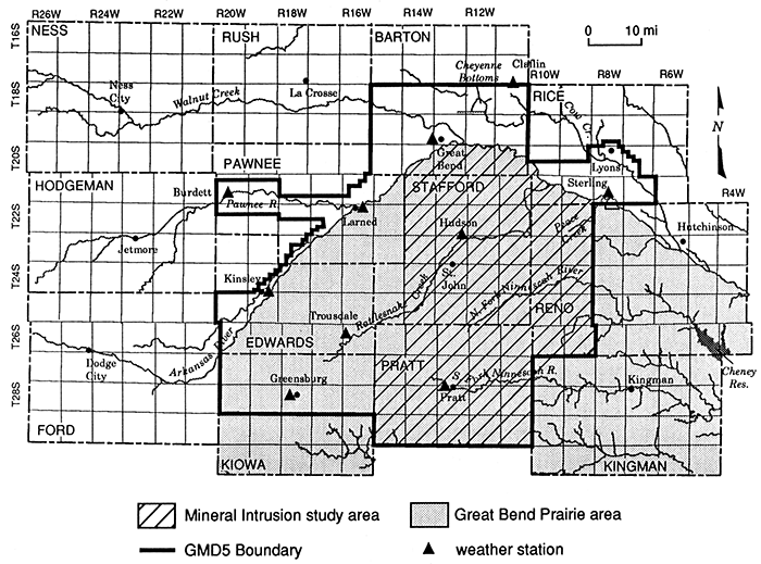
Figure 2--A. Map of the bedrock beneath the Great Bend Prairie Aquifer showing the areas in which the Permian formation has the potential to contribute saltwater to the overlying aquifer. B. Vertical section from west to east across the region, showing the relation of the alluvial Great Bend Prairie Aquifer to the underlying Dakota and Permian formations.
In this report we first discuss the environmental setting and water resources background of the study, address some general principles of hydrologic research and ground-water management that are relevant to the research, and then describe the experimental approach and expected outcomes of the study. Supporting documents provided by the KWO, GMD5, and the Division of Water Resources (DWR) that provide further information on the planned study and the concerns of the agencies most directly involved are attached as appendixes.
Kansas Geological Survey, Geohydrology
Placed online Feb. 17, 2016; originally released Sept., 1992
Comments to webadmin@kgs.ku.edu
The URL for this page is http://www.kgs.ku.edu/Hydro/Publications/1992/OFR92_25/index.html