Kansas Geological Survey, Open-file Report 88-43
KGS Open File Report 88-43
December 1988
The Kansas Geological Survey is conducting a comprehensive, multiyear research program on the Dakota aquifer in Kansas to fulfill the future water-information needs of planners and managers in local and state agencies. The goal of the program's first year is to develop a research plan that fulfills the Dakota aquifer water-information needs of the future by characterizing the geology and hydrology of the Dakota aquifer and assessing the suitability of various tools for collecting geologic and petrophysical data. To accomplish this KGS is critically examining what is already known about the Kansas part of this aquifer system. The purpose of this report is to show the progress made thus far in the Dakota aquifer program during the first year by describing the various activities and tasks being undertaken by KGS, the U.S. Geological Survey, and other agencies or institutions and by presenting any preliminary results.
During the first year of the Dakota aquifer program KGS is: (1) working with other local, state, and federal agencies to develop hydrologic and geologic data bases that will be used to regionally characterize the. Dakota aquifer, including a wireline log data base; (2) conducting short-term field studies to provide insight into various hydrologic and geologic aspects of the Dakota aquifer system in Kansas, including stream/aquifer interaction in Russell County, an areal reconnaissance of the Codell Sandstone aquifer with Fort Hays State University; and examining energy use in high capacity wells along with the U.S. Geological Survey and the Kansas Energy Extension Service at Kansas State University to develop guidelines and realize energy conservation benefits; (3) defining the regional geologic framework of the Dakota aquifer and associated rock units; and (4) determining the feasibility of using seismic reflection methods to provide data in areas of sparse coverage.
Thus far in the first year of the program KGS has found that: (1) development of the Dakota aquifer is presently restricted to areas where the aquifer is in the near-surface environment of northern, south-central, and southwest Kansas, where the aquifer is a major source of water for irrigation, public water supply, and industrial use; (2) subsurface mapping of the thickness and geometry of the sandstone aquifers in the Dakota aquifer is possible if a sufficient density of data is available and the regional geologic framework can be extended to the more local level of the mapped area; and (3) the potential for upward migration of saline waters into freshwater zones in the Dakota aquifer and surface waters is high in parts of central Kansas especially where fresh and saltwater aquifer systems are hydraulically connected. From these findings KGS has concluded that: (1) the focus of the first few years of the Dakota aquifer program should be in the developed areas of northern, south-central, and southwest Kansas where local and state water-planners and managers need updated information on this aquifer system; (2) a thorough understanding of the geologic framework coupled with a sufficient density of data can be used to predict the likelihood of finding water; and (3) attention must be paid to the vertical hydraulic relationships between aquifer systems as they promote the upward movement of saline waters into freshwater zones and the pathways of migration of these saline waters.
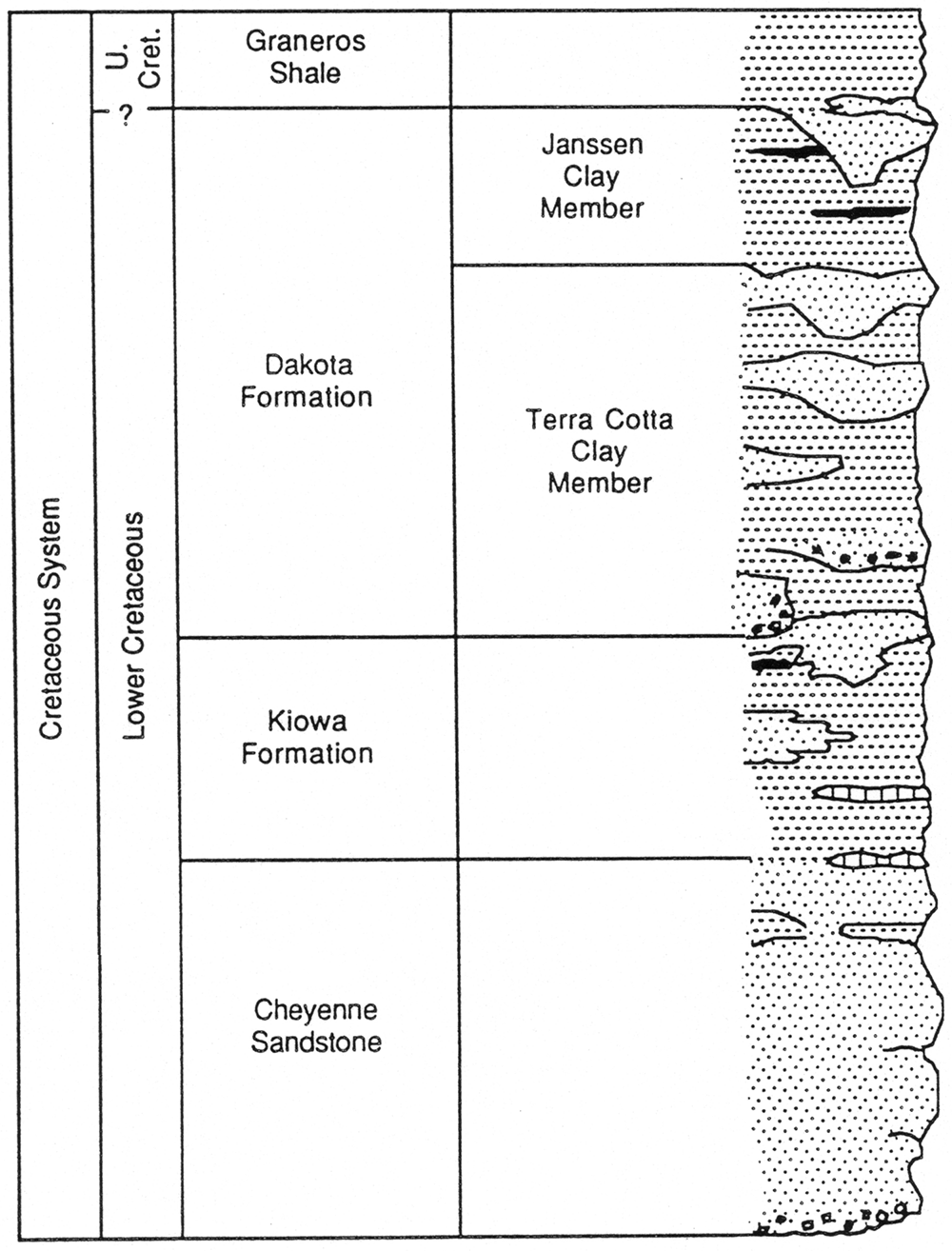
Since the beginning of FY89, the Kansas Geological Survey has been conducting a comprehensive, long term program of research on the Dakota aquifer in Kansas to address future water-resources management and planning needs of local and state agencies. The Dakota aquifer system is an integral part of future water-resources planning for western and south-central Kansas in the coming decades. It is the second most extensive aquifer in Kansas after the High Plains aquifer (Ogallala and associated alluvial aquifers). Figure 1 shows the areas of Kansas underlain by the rocks that comprise the Dakota aquifer. Figure 2 is a schematic stratigraphic column showing the major geologic units that comprise the Lower Cretaceous rocks and the Dakota aquifer in Kansas. In the future, depletion of the High Plains aquifer due to overdevelopment and insufficient recharge will' cause critical water shortages to occur in several areas of western Kansas. The Dakota aquifer will be the next available source of water for the region.
Figure 1—Distribution of the Lower Cretaceous rocks that comprise the Dakota aquifer in Kansas.
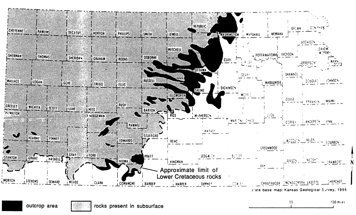
Figure 2—Schematic stratigraphic column showing the distribution of rock types and sandstone aquifers in the Lower Cretaceous rocks.
The goal of the first year of the program is to develop a research plan that fulfills the Dakota aquifer water-information needs of the future. In order to accomplish this goal KGS is: (1) regionally characterizing the Dakota aquifer in Kansas using existing information; (2) broadly defining the geologic framework of the aquifer and adjacent geologic units, and (3) assessing the feasibility of using various geologic and geophysical techniques to describe the Dakota aquifer, especially in areas of sparse data coverage. The methodology being used is to critically examine what is already known about this aquifer system and to develop a set of tools to provide useful information. As part of this work, several water-related and geologic data bases are being developed that will be accessed and expanded as the Dakota aquifer program proceeds. Most of this information will be made available to users through the Kansas Water Data Base. Since the first year of this program is funded from the Kansas portion of the oil-overcharge, KGS is working with the U.S. Geological Survey and the Kansas Energy Extension Service to address energy conservation issues related to high-capacity wells and irrigation systems that withdraw water from the Dakota aquifer.
The Kansas Geological Survey's involvement in the Dakota aquifer began with a study evaluating the continued suitability of shallow underground injection of oil-field brines in the Cedar Hills Sandstone in central Kansas for the Kansas Corporation Commission. This involved defining the geology, hydrology, and water chemistry of the Cedar Hills and overlying aquifer units, including the Dakota aquifer. Much of our effort was guided by the Interagency Dakota Technical Committee whose members include representatives of all of the local, state, and federal water- related agencies. Appendix A is the abstract of the report on this research that was submitted to the Kansas Corporation Commission this year. Appendix B is an abstract of a paper on the hydrogeochemical evidence of hydraulic connection between the Dakota aquifer and the Cedar Hills in the study area.
It became clear that insufficient information concerning the Dakota aquifer was a limiting factor in the state water management and planning process. For the most part, this has resulted from a lack of research structure and coordinated effort that has precluded the integration of research results into a consistent picture of the Dakota aquifer. The KGS with Committee support decided that a significant coordinated research effort on the Dakota aquifer is needed to develop a sound technical basis on which future water-management and planning efforts can depend.
Responding to this need, the Kansas Geological Survey proposed to conduct a comprehensive multi-phased, multi-agency study of the Dakota aquifer system in Kansas. The proposed objectives of the program are: (1) to develop a usable and detailed geologic framework of the Dakota aquifer and related rocks that extends from the outcrop areas of central Kansas to the Colorado and Nebraska state lines; (2) to develop a better understanding of the structural configuration of the aquifer; (3) to characterize water availability, the movement of ground water and the variation of water chemistry within the Dakota aquifer system on a regional and sub-regional basis; and (4) to assess the effects of various water-management scenarios on the performance of the Dakota aquifer using three-dimensional mathematical simulations (ground-water models). In order to facilitate the execution of the Dakota aquifer program a memorandum of understanding was signed by all of the local, state, and federal water-related agencies in Kansas pledging their support for the program. This program was to be undertaken in several phases over a period of 14 years. However, it appears that considerably less time may be required for completion of the program due to an accelerated research program schedule over the next two years. KGS is already committing a considerable portion of its resources to ensure the successful completion of this research program and expects to continue this effort.
Funding for the first year of the Dakota aquifer Program became available in August, 1988, from the Kansas portion of the U.S. Department of Energy-managed oil-overcharge fund. In anticipation of the oil-overcharge funding, KGS began work on the Dakota aquifer program at the beginning of the fiscal year using its own and other budget resources. Even though the funding was delayed, KGS has concentrated its efforts to maintain a research schedule to meet many of its scheduled deadlines.
The purpose of this report is to describe in detail the activities of the KGS and USGS in the Dakota aquifer program since receipt of the oil-overcharge funding and present some preliminary results. Research papers describing in detail the results from the Dakota aquifer program are provided in the appendices at the end of this summary.
OFR 88-43 (Adobe Acrobat, 17.2 MB)
Kansas Geological Survey, Geohydrology
Placed online Jan. 30, 2019
Comments to webadmin@kgs.ku.edu
The URL for this page is http://www.kgs.ku.edu/Hydro/Publications/1988/OFR88_43/index.html