Kansas Geological Survey, Open-file Report 88-21
by
Sabine E. Bock and Howard G. O'Connor
KGS Open File Report 88-21
March 1988
The purpose of this project is twofold:
Studies using mathematical models to determine recharge rates and areas, flow, and general aquifer conditions of the Ogallala have been conducted (Reddell, 1970, Claborn, Austin, and Wells, 1970, Rayner, 1970), but no comparison was possible with actual field data. Recharge is a very sensitive parameter as far as models are concerned and a factor of "insecurity" as to how accurate and reliable those models are always remains.
It was decided to test the Ogallala aquifer for environmental (tritium, 3H) and stable (oxygen-18, 18O; deuterium, 2H) isotopes, freon, atrazine and nitrates in order to be able to distinguish between older and modern waters and thus gain information about potential recharge areas and the rate of flow. In doing so a comparison of field data with existing models would be possible and the reliability of the models would be established or questioned.
Results of this project will help to improve water management in the investigated area, the management district, the water users, and those regulatory agencies concerned with sanitary- and hazardous-waste disposal will benefit.
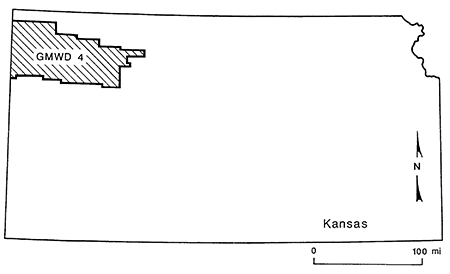
Northwest Kansas Groundwater Management District 4 was chosen as a study area (Fig.1).
Figure 1--Study area
The project was divided into two phases. Phase 1 was concerned with establishing the most suitable analytical methods to date the Ogallala ground water, and phase 2 will expand the sampling net in both the saturated and unsaturated parts of the Ogallala using the isotopes determined to be the most suitable.
For phase 1, nine wells were selected in early October 1987 in cooperation with the management district, using mainly proximity to lineaments as a selecting criterion (Fig. 2). Seven of these wells were already existing wells, which we had information about and permission to use for sample collection. Because of lack of time and funds, only two monitoring wells were installed in late October 1987 by the Kansas Geological Survey. Table 1 gives the designated well names (also used for labeling water samples taken from the respective wells), legal locations, and counties for all nine wells. Table 2 gives total depth, screened depth, and use of the wells.
Figure 2--Lineaments and well locations (from McCauley, 1988)
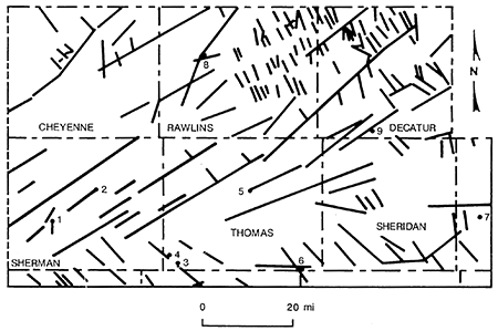
Table 1--Well Designations and Locations of Ogallala Wells.
| Site 1, Gannon | T9S, R41W, sec. 11, DDA | Sherman |
| Site 2, Goodland | T8S, R39W, sec. 8, BAB | Sherman |
| Site 3, Playa | T10S, R36W, sec. 21, BCC | Thomas |
| Site 4, Starns | T10S, R36W, sec. 18, BCC | Thomas |
| Site 5, Colby | T8S, R33W, sec. 4, ACA | Thomas |
| Site 6, Oakley | T11S, R31W, sec. 6, DCB | Gove |
| Site 7, Graham | T8S, R25W, sec. 36, CAA | Graham |
| Site 8, Rawlins | T2S, R35W, sec. 34, AAA | Rawlins |
| Site 9, Dairy | T5S, R29W, sec. 25, CBA | Decatur |
Table 2--Total Depth, Screened Depth, and Use of Wells.
| Well | Total Depth | Screened Depth | Use |
|---|---|---|---|
| Site 1, Gannon | 298 ft | 168-298 ft | monitor |
| Site 2, Goodland | 197 ft | 147-197 ft | monitor |
| Site 3, Playa | 152 ft | 122-152 ft | monitor |
| Site 4, Starns | 137 ft.* | irrigation | |
| Site 5, Colby | 200 ft | 155-195 ft | monitor |
| Site 6, Oakley | 190 ft | 170-190 ft | none |
| Site 7, Graham | 32 ft | 21-31 ft | monitor |
| Site 8, Rawlins | 90 ft | 80-90 ft | domestic |
| Site 9, Dairy | 180 ft | 126-176 ft | Dairy |
| *Estimated depth from surface elevation and bedrock-contour maps. | |||
From November 10 through November 13, 1987, we collected water samples from the wells for the isotopes 18O, 2H and 3H, and freon, atrazine, nitrate and general water chemistry. Where possible the samples were taken using a Bennett sample pump, provided by GWMD #4. In addition one precipitation sample was collected by the Kansas State University Experiment Station at Colby on November 8.
Read the PDF version (300 kB)
Kansas Geological Survey, Geohydrology
Placed online May 8, 2014
Comments to webadmin@kgs.ku.edu
The URL for this page is http://www.kgs.ku.edu/Hydro/Publications/1990/OFR88_21/index.html