|
|
|
|
KGS, Open-file Report 1999-15 |
by Ricardo A. Olea and John C. Davis
Kansas Geological Survey
KGS Open File Report 1999-15
May 1999
The Kansas Geological Survey (KGS) and the Division of Water Resources (DWR) monitor a network of observation wells in central and western Kansas for the purpose of determining annual changes in water level in the High Plains aquifer and other aquifers. The observation network in the High Plains aquifer is intended to have a maximum uncertainty of ±10 ft in water-level elevation anywhere within the interior of the network. There are locations where this standard is not met, either because of loss of observation wells from the network over time or defects in the original network design.
We recommend that 28 new observation wells be added to the High Plains aquifer network to compensate for locally inadequate sampling. Four more observation wells should added to verify data collected from wells that exhibit aberrant changes in year-to-year water-level measurements. Readings from these wells may be the result of unusual but real fluctuations in water level in the aquifer, or they may be caused by poor mechanical conditions in the observation wells that make the measurements unreliable.
Locations where additional observation wells and verification wells should be located are shown on maps and listed in tables. One new observation well should be designated as close as possible (within a radius of 2.5 mi) to each set of specified coordinates.
List of Plates
The Kansas Geological Survey (KGS) and the Division of Water Resources (DWR) measure water levels in observation wells in central and western Kansas to monitor the water content of underground aquifers used for irrigation, domestic, and commercial water supply. Most of the observation wells penetrate the High Plains aquifer in a fairly systematic spatial pattern, forming a "network" that is intended to provide a reliable picture of the water level within the aquifer.
In theory, the best possible configuration for a water-level observation network would consist of wells located at the centers of uniform hexagons arranged in a regular pattern (Olea, 1984). Because the present observation well network was originally constructed using wells that already were being monitored, and the practical limitations on the choice of additional wells that can be used for monitoring purposes, the Kansas High Plains aquifer observation network does not conform to the ideal regular hexagonal pattern. However, over the last two decades there has been systematic progress in modifying the network to approximate the ideal sampling pattern.
This study reviews the reliability of the observation well network for estimating water levels in the High Plains aquifer and proposes modifications to improve collection of data and reduce uncertainty in the network.
There were 1,272 High Plains aquifer observation wells to be measured during the January 1999 data collection program. Of these, 1,204 were successfully measured (Olea and Davis, 1999). According to Miller and Davis (1999, p. 7-8), there are 37 wells that should be removed from the network and not measured in the future because these wells have serious mechanical problems that make them difficult or impossible to measure. Of those wells, 31 tap the High Plains aquifer. These are listed in Table 1.
Table 1. Observation wells in the High Plains aquifer that should not be measured in the year 2000 for mechanical reasons.
| Map Index | Location |
|---|---|
| 1375 | 02S 35W 34CAA 01 |
| 1346 | 03S 42W 26CCD 01 |
| 1337 | 04S 35W 06DCD 01 |
| 1176 | 07S 33W 35ADD 01 |
| 1170 | 08S 29W 01DCB 01 |
| 1050 | 08S 38W 17CDD 01 |
| 1001 | 15S 40W 26CAB 01 |
| 990 | 16S 38W 10ABB 01 |
| 786 | 21S 18W 32DAA 01 |
| 814 | 21S 22W 12BCB 01 |
| 691 | 23S 01W 19AAC 01 |
| 696 | 23S 39W 15ADD 01 |
| 637 | 24S 08W 04AB 01 |
| 554 | 24S 18W 36DDC 01 |
| 564 | 24S 26W 35CBC 01 |
| 517 | 25S 02W 16DDB 01 |
| 521 | 25S 33W 17DBD 01 |
| 483 | 25S 33W 33CDA 01 |
| 407 | 26S 01W 31CCD 01 |
| 383 | 27S 32W 03CBB 01 |
| 344 | 27S 38W 23CBB 01 |
| 353 | 27S 40W 16CCC 01 |
| 249 | 28S 19W 30CBC 01 |
| 239 | 28S 40W 32CCB 01 |
| 222 | 29S 15W 02CCA 01 |
| 216 | 29S 37W 08CBA 01 |
| 132 | 30S 34W 30ADD 02 |
| 106 | 31S 39W 23BBB 01 |
| 90 | 32S 38W 11ADA 01 |
| 49 | 33S 38W 20DDB 01 |
| 59 | 33S 43W 08BDA 01 |
Miller and Davis (1999, p. 8) have identified an additional 24 wells that have erratic year-to year fluctuations. Most of these wells tap aquifers other than the High Plains aquifer. The 13 erratic wells that tap the High Plains aquifer are listed in Table 2.
Table 2. Observation wells in the High Plains aquifer that are erratic in their year-to-year behavior.
| Map Index | Location |
|---|---|
| 813 | 21S 39W 07CBA 01 |
| 683 | 23S 33W 26ABB 01 |
| 668 | 23S 33W 28CDC 01 |
| 694 | 23S 34W 17CCC 01 |
| 51 | 33S 35W 23CBB 01 |
| 78 | 32S 36W 21AAC 01 |
| 97 | 31S 26W 30BBB 01 |
| 113 | 31S 28W 10BCB 01 |
| 121 | 30S 26W 32DDD 01 |
| 330 | 27S 23W 28AAA 01 |
| 484 | 25S 34W 34DBD 01 |
| 682 | 23S 35W 25BBB 03 |
| 684 | 23S 34W 21DDC 01 |
If these 44 wells are removed, there will be 1,228 dependable wells in the High Plains observation network. Plate 1 is a posting showing the locations of all wells listed in Tables 1 and 2.
The kriging standard deviation is used in geostatistics as a measure of reliability in spatial estimation (Olea, 1999, ch. 10). The larger the kriging standard deviation, the greater the uncertainty in the associated estimate, or stated in another way, the less reliable is the estimate.
In 1997, when the KGS assumed responsibility for measuring observation wells previously measured by the U.S. Geological Survey, it was agreed that a desirable and achievable level of reliability for the High Plains aquifer network could be set at a maximum kriging standard deviation of 10 ft in those areas of the major aquifer that were free from border effects (Olea, 1997a). Plate 2 is a map showing the kriging standard deviation that would be obtained if the 1,228 observations wells that are considered measurable and reliable were measured.
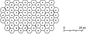
Based on the standard that the maximum kriging standard deviation inside the central portions of the High Plains aquifer should not exceed 10 ft, all of the isolated areas shown in orange or green on Plate 2 are undersampled. Each year since 1997, locations where additional observation wells are necessary have been proposed (Olea, 1997a; Olea, 1997b; Olea, 1998). Selecting these well locations is straightforward--it has been theoretically determined and confirmed in practice that, for the semivariogram of the residuals of the water-level elevation, it is sufficient to have one well in each hexagon of radius 4.5 km, arranged in a regular hexagonal pattern, to achieve a kriging standard deviation of less than 10 ft. Figure 1 shows the appropriate hexagonal network drawn at the same scale as the maps in Plates 1-3.
Figure 1. Regular hexagonal network of observation wells in the High Plains aquifer required to reduce the maximum uncertainty in water level to ±10 ft.
An advantage of using the kriging standard deviation as the measure of uncertainty is that its value depends on the semivariogram and the spatial configuration of the observation points, and not on the individual measurements of water level (Olea, 1999, p. 24-25). Plate 3 is a map of the kriging standard deviation that would be obtained if 32 wells were added to the network at the locations specified in Table 1. Note that wells do not have to be placed precisely at the positions specified. Depending on the locations of neighboring observation wells, usually any spot within a hexagon circumscribed by a circle 2.5 mi (4 km) in radius and centered at the listed position will result in a kriging standard deviation that is less than 10 ft. Of course, the closer a well can be found to the specified location, the greater and more uniform the reduction in kriging standard deviation.
In Table 3, identification numbers less than 70 are the same well locations that were proposed previously. Identification numbers below 50 are locations originally proposed in 1997 (Olea, 1997b), and numbers between 50 and 70 represent locations first proposed in 1998 (Olea, 1998). This year for the first time we suggest two types of new observation wells. Locations with identification numbers between 70 and 90 indicate where wells are needed to compensate for original inadequate control or to replace one of the 31 wells to be deleted from the network because of serious mechanical problems.
The four locations with identification numbers in the 90s are needed to verify anomalous water-level measurements from wells where the kriging standard deviation would exceed 10 ft if the erratic wells were dropped from the network. At the present, we recommend that all 13 anomalous observation wells listed in Table 2 continue to be measured, because their unusual readings may represent true behavior of the aquifer and not the result of poor mechanical conditions in the observation wells. New observation wells at locations 91-94 will provide a check on these readings; if the new wells also behave in an unusual manner, this will confirm that the behavior is real and not a sampling artifact.
Table 3. Centroids of proposed locations for new wells required to reduce the kriging standard deviation below 10 ft in the High Plains aquifer.
| Map Index |
UTM Coordinates | Location | County | |
|---|---|---|---|---|
| Easting, m | Northing, m | |||
| 4 | 251813.88 | 4387669.46 | 5S 41W 23 | Cheyenne |
| 5 | 366500. | 4400000. | 4S 29W 3 | Decatur |
| 6 | 362000. | 4391500. | 4S 29W 32 | Decatur |
| 9 | 350000. | 4206000. | 24S 31W 3 | Finney |
| 13 | 352092.75 | 4180125.80 | 26S 31W 26 | Finney |
| 92 | 331000. | 4207500. | 24S 33W 3 | Finney |
| 93 | 317500. | 4210000. | 23S 34W 29 | Finney |
| 94 | 324000. | 4214000. | 23S 34W 13 | Finney |
| 18 | 293505.49 | 4147498.97 | 30S 37W 11 | Grant |
| 71 | 294000. | 4170000. | 27S 37W 35 | Grant |
| 72 | 298000. | 4161000. | 28S 36W 32 | Grant |
| 21 | 379130.00 | 4165221.08 | 28S 28W 10 | Gray |
| 22 | 360000. | 4157000. | 29S 30W 3 | Gray |
| 25 | 324079.64 | 4146795.04 | 30S 34W 12 | Haskell |
| 76 | 268000. | 4137000. | 31S 40W 13 | Morton |
| 77 | 269000. | 4129000. | 32S 39W 7 | Morton |
| 29 | 310500. | 4397000. | 4S 35W 14 | Rawlins |
| 61 | 310000. | 4385500. | 5S 35W 23 | Rawlins |
| 54 | 576500. | 4207000. | 238 7W 31 | Reno |
| 56 | 598000. | 4210000. | 23S 5W 21 | Reno |
| 33 | 343000. | 4138303.33 | 31S 32W 2 | Seward |
| 34 | 347000. | 4111000. | 33S 31W 32 | Seward |
| 75 | 264000. | 4157000. | 29S 40W 14 | Stanton |
| 57 | 283000. | 4138000. | 31S 38W 9 | Stevens |
| 58 | 283000. | 4129000. | 32S 38W 9 | Stevens |
| 73 | 296000. | 4136000. | 31S 37W 14 | Stevens |
| 74 | 276000. | 4136000. | 31S 39W 14 | Stevens |
| 78 | 312500. | 4111000. | 33S 35W 34 | Stevens |
| 79 | 303000. | 4130000. | 32S 36W 3 | Stevens |
| 80 | 295000. | 4118000. | 33S 37W 11 | Stevens |
| 81 | 295000. | 4108000. | 34S 37W 11 | Stevens |
| 91 | 303000. | 4121000. | 32S 36W 34 | Stevens |
The uncertainty near the five wells listed in Table 4 exceeds the minimum standards, but because these wells are located on or near the boundaries of the High Plains aquifer, this is not surprising. Accurately sampling the edges of the High Plains aquifer is not a priority at present, so no action is recommended to investigate the reliability of water level measurements in areas surrounding these wells.
Table 4. Observation wells in the High Plains aquifer that are erratic but are located near the aquifer boundary.
| Map Index | Location |
|---|---|
| 813 | 21S 39W 07CBA 01 |
| 330 | 27S 23W 28AAA 01 |
| 113 | 31S 28W 10BCB 01 |
| 121 | 30S 26W 32DDD 01 |
| 97 | 31S 26W 30BBB 01 |
Field reports on the mechanical conditions of wells, combined with a year-toyear analysis of changes in water level at individual wells and geostatistical analysis, supports the following conclusions and recommendations:
Miller, R.D., and J.C. Davis, 1999, 1999 Annual Water Level Raw Data Report for Kansas: Kansas Geological Survey Open-File Report No. 99-5, 271 p. and 1 compact disk.
Olea, R.A., 1984, Sampling design optimization for spatial functions: Mathematical Geology, vol. 16, no. 4, p. 369-392.
Olea, R.A., 1997a, Sampling Analysis of the Annual Observation Water-Level Wells in Kansas: Kansas Geological Survey Open-File Report No. 97-73, 44 p.
Olea, R.A., 1997b, Modifications to the High Plains Aquifer Observation Network Expansion in Open-File report 97-73: Kansas Geological Survey Open-File Report No. 97-84, 3 p., 1 plate.
Olea, R.A., 1998, Proposed Expansion of the High Plains Aquifer Observation Network for Reliability Enhancement: Kansas Geological Survey Open-File Report No. 98-39, 3 p., 2 plates.
Olea, R.A., 1999, Geostatistics for Engineers and Earth Scientists: Kluwer Academic Publishers, New York, 303 p.
Olea, R.A., and J.C. Davis, 1999, Sampling Analysis and Mapping of Water Levels in the High Plains Aquifer of Kansas: Kansas Geological Survey Open-File Report No. 99-11, 35 p. and 9 plates.