Kansas Geological Survey, Open-file Report 2004-12
Part of the Direct Push Methods for Hydrostratigraphic Characterization Project
by
Stephen M. Sellwood1,2, John M. Healey1, Steffen Birk1,3, and James J. Butler, Jr.1,4
1) Kansas Geological Survey, 1930 Constant Ave., Campus West, University of
Kansas, Lawrence, KS 66047
2) currently at BT2, Inc., 2830 Dairy Drive, Madison, Wisconsin 53718
3) currently at Center for Applied Geoscience, University of Tübingen,
Sigwartstr. 10, D-72076 Tübingen, Germany
4) Corresponding author
KGS Open File Report 2004-12
March 2004
ofr04_12.pdf (316k)
To read this file, you will need the Acrobat PDF Reader, available free from Adobe.
Figure 5a--A three-dimensional image of electrical conductivity at GEMS viewed from the southeast of the profiling grid (approximate surface locations of profiles are marked; origin of grid coordinate system at HP8; interpolation performed with inverse-distance weighting (exponent = -3.5) algorithm in Tecplot (Amtec Engineering 2001); shapes of many of the smaller-scale features are artifacts of the grid spacing and the interpolation algorithm).
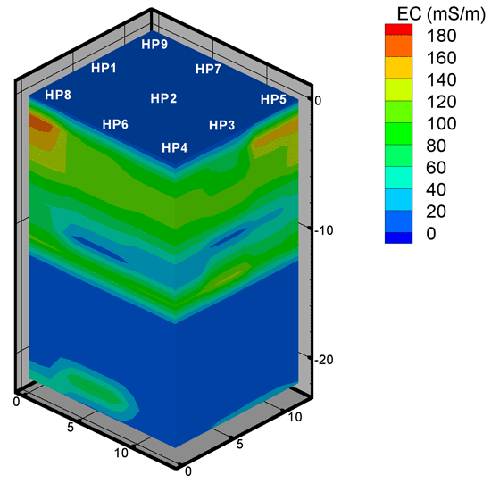
Figure 5b--A three-dimensional image of electrical conductivity at GEMS viewed from the northwest of the profiling grid (approximate surface locations of profiles are marked; origin of grid coordinate system at HP8; interpolation performed with inverse-distance weighting (exponent = -3.5) algorithm in Tecplot (Amtec Engineering 2001); shapes of many of the smaller-scale features are artifacts of the grid spacing and the interpolation algorithm).
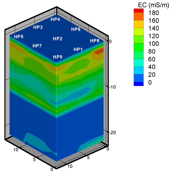
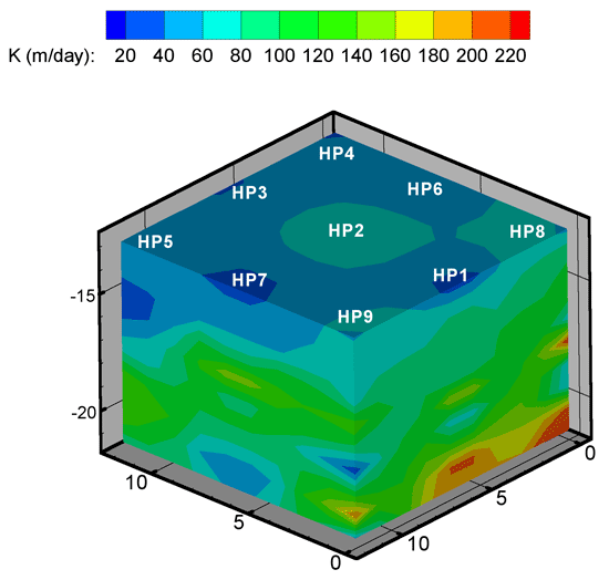
Figure 7a--A three-dimensional image of hydraulic conductivity within the sand and gravel interval at GEMS viewed from the southeast of the profiling grid (approximate surface locations of profiles are marked; origin of grid coordinate system at HP8; interpolation performed with inverse-distance weighting (exponent = -3.5) algorithm in Tecplot (Amtec Engineering 2001); shapes of many of the smaller-scale features are artifacts of the grid spacing and the interpolation algorithm).
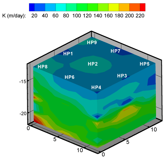
Figure 7b--A three-dimensional image of hydraulic conductivity within the sand and gravel interval at GEMS viewed from the northwest of the profiling grid (approximate surface locations of profiles are marked; origin of grid coordinate system at HP8; interpolation performed with inverse-distance weighting (exponent = -3.5) algorithm in Tecplot (Amtec Engineering 2001); shapes of many of the smaller-scale features are artifacts of the grid spacing and the interpolation algorithm). 35