R. W. Buddemeier
Boldface items are linked to other sections; italic items are linked to glossary definitions
This atlas of the High Plains Aquifer in Kansas has been prepared by the Kansas Geological Survey under contract to the Kansas Water Office. The immediate purpose of the atlas is to provide technical information in response to a mandate by the Kansas Legislature to the Kansas Water Authority for a report on a range of water resource issues relevant to Kansas. Excerpts from the contract that detail the objectives and specific products are attached.
The electronic version of this atlas is a preliminary presentation of work in progress, subject to review, correction and revision. While every effort has been made to ensure that it is accurate and informative, it is not appropriate for use in local, detailed, or highly quantitative analyses. It does not have official or regulatory status, and should not be used in place of maps that have been subject to technical review and/or official adoption.
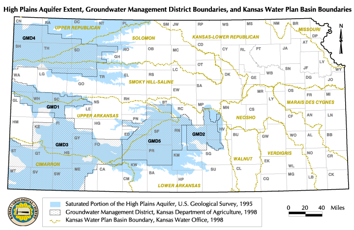
The High Plains aquifer and the other Kansas aquifer units that interact with it are described in the atlas section on Aquifers of the High Plains Region. The High Plains aquifer is a large (approximately 33,500 square miles of surface area) body of sands, gravels, silts and clays. In western Kansas it is generally identical with the Ogallala formation, and the aquifer system was originally known as the Ogallala aquifer. However, the part of the aquifer extending into south-central Kansas (east of Ford county) is now recognized as hydrologically similar but geologically different formations, and the combined aquifer system is referred to as the High Plains. The map linked below shows the geographic extent of the saturated portion of the aquifer. Superimposed on the map of the physical boundaries of the aquifer are the counties (with abbreviated identifiers) and two important sets of administrative boundaries. The Groundwater Management Districts (GMDs) are responsible for managing the groundwater within their boundaries, and the river basins provide the geographic basis for the development and implementation of the Kansas Water Plan. These are not the only relevant political boundaries; various types of districts (watershed, conservation, assurance, local environmental protection, etc.) all have an effect on the water resource. However, a detailed enumeration of local entities is beyond the scope of this aquifer-scale description.
This atlas focuses on groundwater and related water resource issues in the High Plains aquifer in western and central Kansas. This region of the state largely depends on groundwater resources, which are, for the most part, fully appropriated and declining in a number of areas. The western two thirds of the state contrasts with eastern Kansas, where precipitation and streamflow are more abundant and the principal aquifer resources generally consist of alluvial deposits that have direct hydrologic connections to the streams. In eastern Kansas there is generally less stress on and competition for groundwater resources. In comparison, the High Plains aquifer of western and central Kansas encompasses a much larger area and contains a greater volume of groundwater, much of which occurs independent of current streamflows. Due to the more arid environment, lack of dependable streamflow, and greater accessibility of groundwater, a large proportion of the water right development in Kansas has occurred within the High Plains aquifer region. The High Plains aquifer region has an integrated agribusiness system based primarily on irrigation, and depends on groundwater resources which, for the most part, are non-renewable under current water use conditions. Kansas water policy and management practices thus must encompass a variety of environmental, economic, and hydrologic issues, of which meeting the water needs of western and central Kansas is among the most challenging.
The primary audience for this atlas is therefore the community of policy-makers, managers, and their technical support staff. At the same time, this information will be useful and of interest to both the general public and to researchers and analysts. To make the presentation as useful and authoritative as possible, it has been organized in a basic pattern of brief summary presentations of the various topics and results, accompanied by illustrative maps or figures. A standard format has been adopted that addresses for each topic:
A glossary of hydrologic, geologic, and environmental terms has been provided; it is linked to the first text appearance of some key terms, but can also be used independently as a dictionary to look up definitions of a wide range of other terms by using the link at the beginning of each section.
The atlas directory provides a list of the sections and appendices, with links for navigation within the atlas. This list includes not only the existing sections, but also identifies items that are planned or in progress for future completion.
Next section: Surface Water in Kansas and its
Interactions with Groundwater
Back to Directory
Funded (in part) by the Kansas Water Plan Fund