M. A. Sophocleous, B. B. Wilson
Boldface links are to other atlas sections; italic items are linked to glossary definitions
Definitions: Surface water can be defined as all water on the surface of the land, including runoff moving across the land surface, streamflow in rivers, creeks, or other natural channels, ground water contributed through seeps or springs, and storage in lakes, ponds, or reservoirs. Streamflow rates are usually expressed in cubic feet per second (cfs), and these rates can be converted to streamflow volume by multiplying the rate by the time interval of interest, usually one year. Thus streamflow volume is usually expressed in acre-feet or in inches of runoff. One inch of runoff represents the volume of water required to cover the entire drainage area of a stream to a depth of one inch.
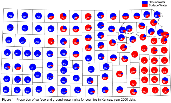
Relevance to understanding water resources: Approximately half of the Kansas population is served by surface water. The distribution of surface water rights in the state is shown in figure 1; Wyandotte County in eastern Kansas diverts the greatest amount of surface water. Because of high variabilities of streamflows, many municipalities and industries in the eastern third of Kansas depend on water stored in major reservoirs to meet current and future needs. Without the benefit of impoundments, flows in all but the largest Kansas streams would be almost zero for 30-day periods during moderate drought conditions.
Discussion: Surface water is distributed unevenly across Kansas mainly because of the state's climate. With few exceptions, western Kansas has little surface water. Ground water is the principal source of freshwater in most of this area. In contrast, ground water is not available in sufficient quantity in most of eastern Kansas, where surface water is the principal source of large supplies (see figure 1 above).
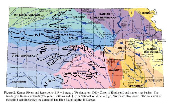
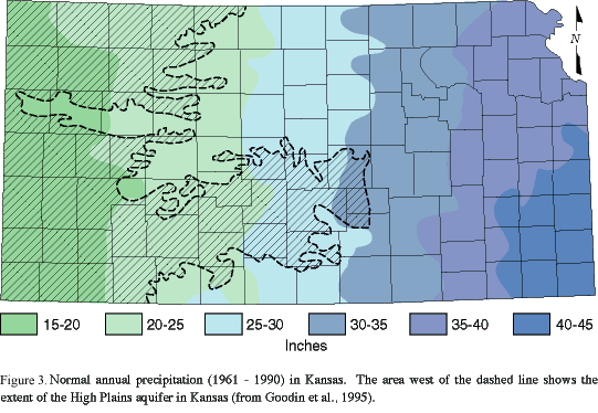
To better manage the water resources of the state, Kansas is divided into 12 major river basins (see figure 2 above), a division based on the philosophy that areas drained by the same stream often have many similar water issues in common. Average annual rainfall ranges from 15 to 18 inches per year in far western Kansas to more than 40 inches per year in southeastern Kansas.
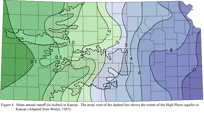
Although this climatically controlled rainfall variation is significant, average annual runoff across the state varies much more than the precipitation. By comparison, the average runoff ranges from approximately 10 inches in the east (25% of precipitation) to 0.1 inch in the west (less than 0.6 of 1% of the precipitation), a 100-fold change in the runoff across the state.
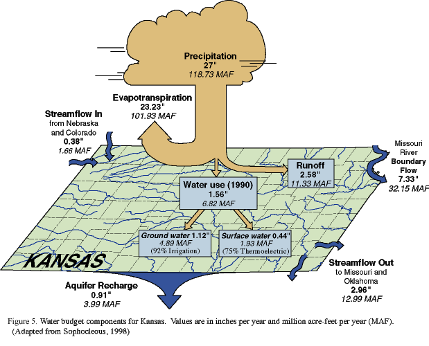
Measured streamflow entering Kansas averages 1.7 million acre-feet annually. About 90% of this incoming streamflow is from southeastern Nebraska; the semi-arid High Plains of eastern Colorado contribute little runoff to Kansas. The flow in ungaged streams entering the state adds little to this total since most of the streams are dry except immediately following heavy rains. The precipitation falling over the state amounts to 118.7 million acre-feet in an average year, and about 13 million acre-feet per year leaves the state as streamflow. The streams annually accumulate 11.3 million acre-feet of runoff within the state. The following figure illustrates these water-budget components for the state of Kansas.
Few natural lakes occur in Kansas. The largest lakes in Kansas are the human-made impoundments formed behind dams built by the U.S. Army Corps of Engineers and the U.S. Bureau of Reclamation. These reservoirs store water for flood control, irrigation, municipal and industrial water supply, and other uses. Twenty-four major reservoirs have been built in the state, 17 by the Corps of Engineers and seven by the Bureau of Reclamation. The 24 reservoirs have a total storage capacity of 11 million acre-ft, of which 2.35 million acre-ft are available for conservation (water-supply) capacity to regulate surface water supplies for sustained use in times of drought. Because of the high variability of streamflows, the State has contracted with the Federal government for water-supply storage in 12 of these reservoirs. The state makes water available to municipal and industrial water users through contracting procedures established by statute.
The two traditional methods of obtaining water in Kansas are the Water Appropriation Act (for water rights) and the Water Marketing Program, involving 12 Corps of Engineers reservoirs where the state currently owns storage. The Water Marketing Program in concert with the Water Assurance and Multipurpose Small Lakes Programs, all operated by the Kansas Water Office, provide surface water supplies to approximately 61 Kansas communities, 68 rural water districts, and three public wholesale water supply districts, as well as to commercial and industrial water users. These surface-water supplies serve part or all of 29 Kansas counties.
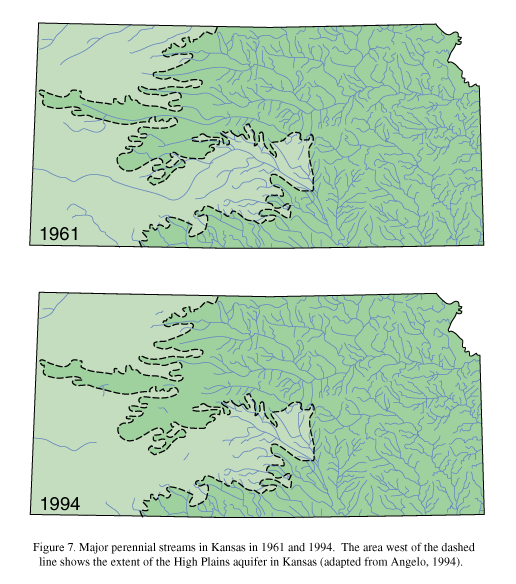
Although the distinction between surface water and ground water seems simple, they are connected in such a way that surface water can become ground water and vice versa, and such surface-ground water interactions generally are difficult to observe and measure. Aquifers are often fed partially by seepage from streams and lakes, and such surface water bodies are known as losing streams or lakes (Figure 6A). In other locations, these same aquifers may discharge through seeps and springs to feed the streams, rivers, and lakes, and such water bodies are known as gaining streams, rivers, and lakes (Figure 6B). Many streams in Kansas gain water from such ground-water seepage, and this streamflow contribution from ground water is known as baseflow. Baseflow keeps the streams flowing during dry periods. For ground water to discharge into a stream channel, the altitude of the water table in the vicinity of the stream must be higher than the altitude of the stream-water surface. Ground-water pumping may lower the altitude of the water table in the vicinity of the stream, in which case ground-water seepage to the stream decreases; in cases of severe, extensive ground-water pumping, the water table in the vicinity of the stream may drop below the altitude of the stream-water surface, in which case the stream will lose water to the underlying aquifer. This seems to be happening in many regions of Kansas, but especially in western Kansas.

Many streams in western Kansas have experienced a progressive reduction in flow during the past three decades. Trends are most dramatic in the upper Arkansas, Cimarron, and Smoky Hill River basins, where a shift toward irrigated crop production has contributed to the lowering of the water table and significantly reduced baseflow contributions to streams from shallow aquifers.
Agricultural conservation practices also contributed to runoff reduction to streams. Declines in flow also exert a direct impact on surface water quality by reducing the dilution base available to effluents from sewage treatment plants and other pollution sources. Reductions in streamflow also aggravate problems associated with the intrusion of highly mineralized groundwater, such as occurs in the Saline River and in Rattlesnake Creek. In an attempt to prevent streams from dwindling in quantity and quality because of declines in baseflow, water diversions, and pollution sources, the state established Minimum Desirable Streamflow (MDS) and Total Maximum Daily Load (TMDL) limits in selected streams in Kansas.
Data Sources and Methods: To evaluate surface-water supplies, continuous records of streamflow for a period of several years are necessary. Reasonable estimates of the quantity and variability of flow available can be made only from records of this nature. Stream gaging stations have been maintained in Kansas for many years to collect the information needed for evaluation of the state's surface water supplies. Streamflow information and water elevations are currently being collected from 143 complete-record stream gaging stations and 19 lakes and reservoirs as the result of cooperative agreements between the U.S. Geological Survey and various state and federal agencies. Near real-time water-level information is currently available on the Internet for stream-gaging stations and lakes (http://ks.water.usgs.gov). Additional information on the water marketing, water assurance, and multipurpose small lakes programs can be found in the Kansas Water Office web page (http://www.kwo.org).
References
Angelo, R. T., 1994, Impacts of declining streamflow on surface water quality: 11th Annual Water and the Future of Kansas Conference Proceedings, Manhattan, KS, p. 1-2
Goodin, D. G., Mitchell, J. E., Knapp, M. C., and Bivens, R. E., 1995, Climate and weather atlas of Kansas-An introduction: Kansas Geological Survey, Educational Series 12, 24 p.
Sophocleous, M. A., 1998, Water resources of Kansas-A comprehensive outline; in, Perspectives on Sustainable Development of Water Resources in Kansas, M. A. Sophocleous, ed.: Kansas Geological Survey, Bulletin 239, p. 1-59
Wetter, L. H., 1987, Water conservation for more crop production in the Great Plains; in, Ground Water Quality and Agricultural Practices, D. M. Fairchild, ed.: Lewis Publishers, p. 13-34
Winter, T. C., Harvey, J. W., Franke, O. L., and Alley, W. M., 1998, Ground water and surface water-A single resource: U.S. Geological Survey, Circular 1139, 87 p.
See also: Recharge
Next section: Aquifers of the High Plains region
Back to Directory
Funded (in part) by the Kansas Water Plan Fund