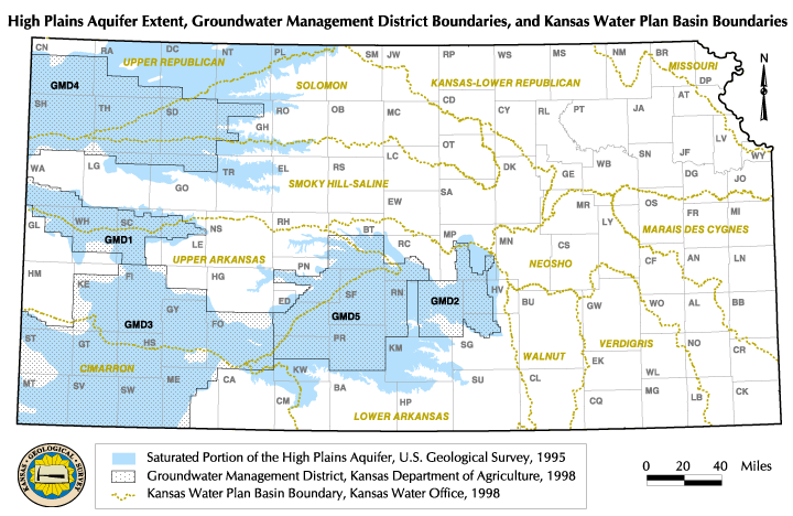
Estimated History of Decline in Saturated Thickness of the Ogallala Portions of the High Plains Aquifer, Groundwater Management Districts, and River Basins
J. J. Woods, J. A. Schloss, J. Mosteller, and R. W. Buddemeier
The Ogallala Aquifer is the western portion of the High Plains Aquifer (from the Colorado border to approximately the eastern boundary of Ford County). This portion of the aquifer has the lowest Recharge and the greatest Changes in Saturated Thickness, and in most areas is managed under "programmed depletion" rather than "safe yield" policies. Under a separate contract, the Kansas Geological Survey has calculated the average rate of change in saturated thickness in the Ogallala Aquifer as a whole, and in the Groundwater Management Districts and the portions of the river basins (see map) overlying the aquifer. Two different approaches were used: one employed data from those wells that had 30 years of measurement record, and the other used all available measurements over the past 11 years.
Although neither of the methods of determination were identical to the calculations used to produce the maps in this atlas (see note on methods and qualifications, below), the general agreement among the results validate the overall findings and provide an adequate comparison of the rates of change at different periods of time.
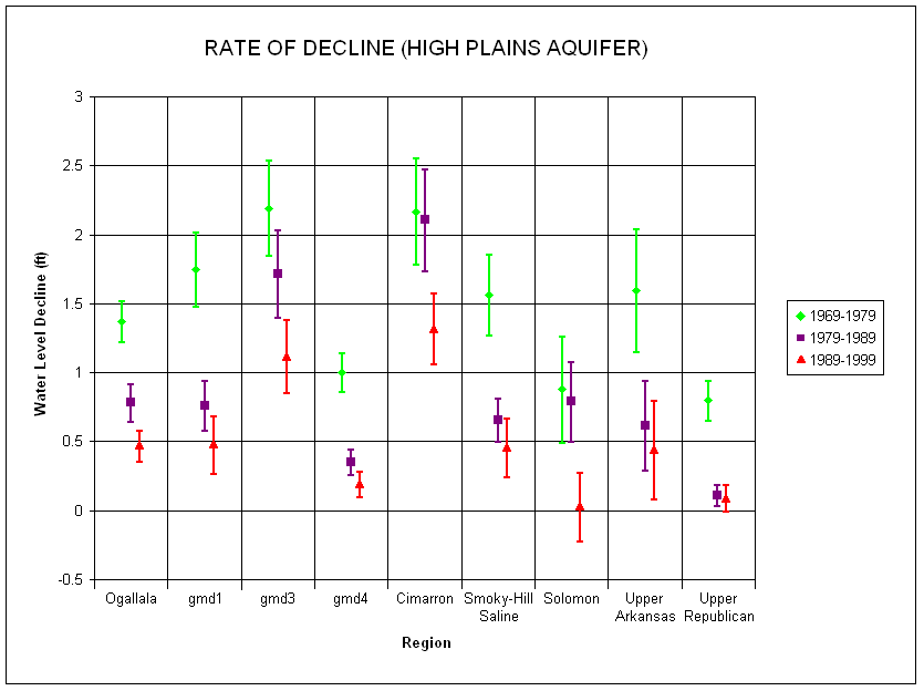
Water level changes determined from wells with long-term records:
Figure 1 (below): Average annual rates (ft/yr) of water-level
change by region for the past three decades (1969-79, 1979-89, and 1989-99).
The central points are the average values, and the vertical lines represent
an uncertainty of one standard deviation -- the range that can be expected
to include about 66% of all of the measurements for that period and region.
Figure 2 (below): Time series of average annual water-level decline rates (ft/yr) for the Ogallala Aquifer regions. Data of figure 1 replotted to show time course of change.
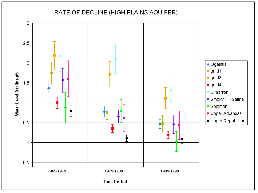
Results: The figures show three major results: (1) rates at which the various regions of the aquifer are declining have generally slowed substantially between the 1969-79 and 1989-99 periods; (2) the changes in the 1979-89 decade are not consistent across the various sub-units; and (3) the pattern and amount of change observed is strongly dependent on the region considered.
Methods and qualifications: The estimates in these figures were produced by averaging the ten-year changes in wells that had measurements in each of the years defining the endpoints of the decades. This method results in more precise individual values, but a much smaller number of wells -- and therefore greater uncertainty as to how well their average represents the behavior of the overall region. In other words, only wells measured in the winters of 1969, 1979, 1989, and 1999 were used, but all of each wells' winter measurements were used in calculating the average for each year.
Another cautionary note is also expressed in the section on Estimated Usable Lifetime; rates of decline may change either because the resource is being used more sustainably -- or because there is not enough left to use. Rate of decline figures needed to be considered in the context of the amount and distribution of the remaining resource; decreasing use in a fringe area (e.g., with 50' of saturated thickness or less) could mask more serious declines in the remaining resource if only averages are considered.
These values are expected to be similar to those obtained in section 1 above for the 1989-99 decade (see right-hand column in figure 2). The general patterns are similar, but differ significantly in detail. Both methods find an average rate of decline of over a foot per year for southwestern Kansas GMD3 and the Cimarron basin, and agree on the small declines for the Solomon and Upper Republican basins. However, figure 2 shows a significant decline for the Smoky Hill-Saline basin and for northwestern Kansas GMD4, whereas Table 1 does not. Compared to Table 1, figure 2 underestimates the declines in the Upper Arkansas basin, western Kansas GMD1, and the Ogallala aquifer as a whole.
These values can then be compared with the estimated usable lifetime estimates. The estimated usable lifetime estimates are systematically different because they take into account saturated thickness, whereas the estimates discussed here simply address change in the elevation of the water table. The estimated useable lifetime map shows the greatest concentration of "hot spots" in GMD1, followed by the Smoky Hill-Saline basin and the Upper Arkansas basin. These findings, especially for the Smoky Hill-Saline basin, tend to generate very different management and planning perspectives than the values shown in Table 1 and figure 2
These differences can be resolved and explained by further analysis, but they point out the importance of developing clear, consistent measures of resource status and changes that take into account both hydrologic principles and the patterns of use.
Table 1: Average water levels by region and trends of change over the past 11 years, projected to 2010.
| Region | Average depth to water (ft) 1999 | Average rate of change (ft/yr) | Projected depth to water (ft), 2010 | Significance |
|---|---|---|---|---|
| Upper Republican | 132.81 | 0.326 | 136.40 | yes |
| Solomon | 111.12 | 0.003 | 111.15 | no |
| GMD4 | 131.37 | -0.171 | 129.49 | no |
| Smoky Hill-Saline | 126.43 | 0.142 | 128.00 | no |
| GMD1 | 133.09 | 0.836 | 142.29 | yes |
| Upper Arkansas | 112.09 | 1.181 | 125.08 | yes |
| GMD3 | 155.59 | 1.594 | 173.12 | yes |
| Cimarron | 182.77 | 1.340 | 197.50 | yes |
| Ogallala aquifer | 135.29 | 0.900 | 145.19 | yes |
Methods and Qualifications: The data for each region were averaged for each year (1989-1999) and analyzed for trends; where a statistically significant change occurred, the "significance" column has a "yes". All significant trends were tested for best fit, and in all cases it was found that a linear trend line was better than any non-linear fit. The trend lines were then extrapolated to the year 2010 and an estimated value determined for that year.
These estimates make use of all available data rather than a limited subset of wells as is the case in the results reported in section 1 above. This should make the results more reliable, but the scale of the determinations in both cases is excessively large compared to the distribution of the resource and its uses. Averages therefore tend to smooth out the very real differences within regions, and paint the depleted, endangered, and relatively "safe" parts of the aquifer with the same brush. These results tend to support the need for developing appropriate techniques for classifying management and planning subunits of the larger regions. The challenge inherent in this is that our databases put limits on the degree of local detail or precision that we can apply at smaller scales.
See also: Estimated Usable Lifetime,
Current Maximum Authorized Use, Current
Saturated Thickness, Groundwater Availability
and Accessibility
Back to Directory
Funded (in part) by the Kansas Water Plan Fund