News Release, Kansas Geological Survey, August 7, 2013
LAWRENCE--A gaping sinkhole that appeared without warning in Wallace County in late July was likely caused by natural dissolution of underground rock and not by irrigation practices or oil and gas drilling, according to the Kansas Geological Survey.
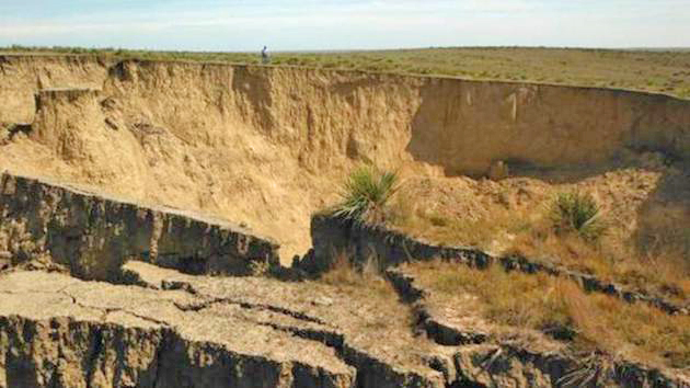
Currently about 200 feet across and 90 feet deep-it could still grow-the sinkhole is north of the town of Wallace in an area of the county with little oil, gas, or groundwater. The water-bearing Ogallala Formation that underlies much of western Kansas, and is heavily tapped for irrigation elsewhere, is noticeably thin or absent near the sinkhole.
"Some people have been speculating that excessive pumping of water from the Ogallala aquifer for irrigation or oil and gas production may have contributed to the collapse," said KGS interim director Rex Buchanan. "But scarcity of such activities and geologic resources in the area make that unlikely."
Whatever its origin, the sinkhole is not without precedence in western Kansas. Several historical collapses have been documented in Wallace County alone, including the Smoky Basin Cave-in that developed about 5 miles east of Sharon Springs in 1926 and grew to an estimated 350-by-250-foot irregular oval. Another, the circular Old Maid Pool,* is about 6 miles northwest of town.
"Dissolution of a 200-foot-thick bed of halite, commonly known as rock salt, that is about 2,000 to 2,200 feet beneath the surface in this area likely led to the formation of these sinkholes as well as the new one," said KGS geologist Lynn Watney.
Following that theory, groundwater penetrating through fractures in overlying layers of Cretaceous chalk slowly dissolved the salt and eventually created a substantial void. When the rock above could no longer sustain the weight, everything from the surface down suddenly collapsed.
In other parts of the state where more is known about the subsurface, most notably around Hutchison where salt has been mined for decades, catastrophic sinks have been more definitively linked to the dissolution of underground salt, gypsum, or other evaporates.
Much is known about the state's geology through mining activity and from oil and gas records, which provide data gleaned from rocks recovered during drilling. Because northeastern Wallace County is short on oil and gas and its salt is too deep to mine economically, data on the subsurface geology there is limited. However, by extrapolating data collected from wells in other parts of Wallace County and western Kansas, Watney and others have been able to determine that the Permian-age salt bed probably extends beneath the site of the collapse, making it a potential contributor to the sinkhole.
*For an aerial view of the Old Maid Pool and Wallace County, see http://mapcarta.com/23237892
Story by Cathy Evans, (785) 864-2195.
Kansas Geological Survey, Public Outreach