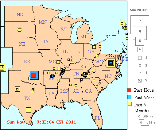
Several earthquakes centered east of Oklahoma City occurred starting 02:12 a.m. on Saturday, Nov. 5, with a 4.7 magnitude quake. The largest occurred at 10:53 p.m. Saturday with a magnitude of 5.6.
The quakes are shown on the Center for Earthquake Research and Information central North American earthquake map. The figure below is adapted from their map.
The earthquakes were widely felt in Kansas. Here are reports of various reactions:
The U.S. Geological Survey National Earthquake Information Center has bulletins on these events:
The pages contain maps and data on the earthquake. In additional, they have a form to fill out if you felt the quake. Evidence from people who have experienced earthquakes is useful in understanding how future quakes will affect a region and in comparing new quakes to historical events.
The Kansas Geological Survey has a Public Information Circular on Earthquakes. Most Kansans have never felt a tremor, but more than 100 earthquakes rumbled through the state betwen 1977 and 1989. This circular acquaints the reader with the theory of plate tectonics, recording and measuring methods, and earthquake activity in Kansas.
Information on earthquakes in the central United States can be found here:
Kansas Geological Survey, Public Outreach
URL="http://www.kgs.ku.edu/General/News/2011/earthquake.html"
Comments to KGS Web Administrator