![]()
Prev Page--Geography || Next Page--Structural Geology
Stratigraphy
The nomenclature here employed for the indurated rock formations in Wyandotte County departs in many respects from previous usage. In their report on the stratigraphy of the Missouri Pennsylvanian, Hinds and Greene based their classification and correlations to a considerable extent on the reports and maps of the early Kansas Geological Survey. [Hinds, Henry, and Green, F. C., Stratigraphy of the Pennsylvanian series of Missouri: Missouri Bur. Geology and Mines, vol. 13, 2d ser., 407 pp., 1915.] Certain errors in correlation made by the Kansas Survey were introduced into the classification of the Missouri Pennsylvanian. The errors in correlation chiefly involve certain units in the Kansas City, Lansing, and Douglas formations of Hinds and Greene. [Hinds, Henry, and Green, F. C., Stratigraphy of the Pennsylvanian series of Missouri: Missouri Bur. Geology and Mines, vol. 13, 2d ser., 407 pp., 1915.] The changes in correlation involving the Kansas City and Lansing groups as here employed were made by Newell as a result of field work in Johnson and Miami counties and southeastern Kansas. Certain changes in the correlation of parts of the Bronson group are based on studies by Jewett, who is making a detailed investigation of those formations. The classification of the major stratigraphic units follows the revision of the Mid-Continent Pennsylvanian by Moore. [Moore, R. C., Kansas Geol. Soc., Guidebook, Sixth Annual Field Conference, pp, 80-97, 1932.] His classification is based on diastrophism as recorded in unconformities and the cyclic recurrence of lithologic types. The essential field observations on which revision of names in the Wyandotte County area are based have been checked by Doctor Moore, and in part they include his independent studies in eastern Kansas and adjoining areas.
The formations exposed in Wyandotte County were traced by the writers from good exposures in Jackson county, Missouri, and from the well-known Leavenworth-Smithville area. [Hinds, Henry, and Greene, F. C., Geologic Atlas of the United States, Leavenworth-Smithville Folio, Missouri-Kansas, United States Geol. Survey, 1917.] More recently the writers either jointly or separately traced all of the formations excepting the Westerville, Bethany Falls and Winterset limestones to the localities from which they were named. In October, 1932, Doctor Moore, in company with Dr. G. E. Condra, state geologist of Nebraska, and Mr. F. C. Greene, of the Missouri Bureau of Geology and Mines, traced subdivisions of the Bronson and Kansas City groups from Kansas City, Mo., to Winterset, Iowa. They determined, among other things, that the type "DeKalb" limestone is really Winterset limestone, and that the beds called Drum by the Missouri Survey at Kansas City, and later identified tentatively as DeKalb, should properly be termed Westerville.
No attempt has been made in this work to prepare faunal charts of the stratigraphic units within the county. The reader is referred particularly to the work of Girty, which is readily applicable to Wyandotte County. [Girty, G. H., Invertebrate Paleontology. The stratigraphy of the Pennsylvanian series in Missouri: Missouri Bur. Geol. and Mines, vol, 13, pp. 263-375, 1915.] The species found in the Pennsylvanian rocks of Kansas and Missouri have been generally regarded as long-ranging in both vertical and areal distribution. To a great extent their value as horizon markers and index fossils has been underestimated. It is the experience of the writers that certain species are of great value in stratigraphical work, either because of their local abundance or occasionally because of their restriction to a particular bed. When these local peculiarities are known, the fossils become of great value in field determination of the various beds. In the following pages such fossils are noted as have proved of value to the writers in identifying the stratigraphic units at different points within the area.
| Generalized section of rocks exposed in Wyandotte County | Thickness, Feet |
|||||
|---|---|---|---|---|---|---|
| Quaternary system: | ||||||
| Recent series: | ||||||
| Alluvium; stream deposits of sand, silt, clay in valley bottoms | 0-100 | |||||
| Colluvium; fragmental talus deposits, humic soil | 0-15 | |||||
| Residual soil; humic soil, clay | 0-5 | |||||
| Recent and Pleistocene series: | ||||||
| Loess, fine, locally arenaceous, clayey, buff to red, wind-blown material | 0-50 | |||||
| Pleistocene series: | ||||||
| Kansas drift: | ||||||
| Glacial erratics, worn local boulders, sand, gravel | 0-8 | |||||
| Unconformity. | ||||||
| Pennsylvanian system: | ||||||
| Virgil series: | ||||||
| Douglas group: | ||||||
| Stranger formation: | ||||||
| Sandstone and shale, massive, soft, micaceous, fine-grained sandstone; some arenaceous shale, generally with a limestone conglomerate at base | 30± | |||||
| Unconformity. | ||||||
| Missouri series: | ||||||
| Lansing group: | ||||||
| Stanton limestone: | ||||||
| Little Kaw limestone member: | ||||||
| Limestone, generally massive, gray, buff, or blue | 3± | |||||
| Victory Junction shale member: | ||||||
| Shale, arenaceous and argillaceous, gray or brown | 7± | |||||
| Olathe limestone member: | ||||||
| Limestone, wavy- and thin-bedded, crystalline, gray to dark | 12± | |||||
| Eudora shale member: | ||||||
| Shale, gray or buff, with black, slaty, middle zone | 6± | |||||
| Captain Creek limestone member: | ||||||
| Limestone, fine-grained, dark, massive | 5.5 | |||||
| Vilas shale: | ||||||
| Shale, arenaceous, buff to gray with layer of calcareous, rippled sandstone near top | 24± | |||||
| Plattsburg limestone: | ||||||
| Spring Hill limestone member: | ||||||
| Limestone, brown to yellow, soft argillaceous | 14± | |||||
| Hickory Creek shale member: | ||||||
| Shale, yellowish-brown with a thin layer of black shale | 0.5± | |||||
| Merriam limestone member: | ||||||
| Limestone, massive, gray, hard, even-bedded, lower part with abundance of Osagia and Myalina | 3± | |||||
| Kansas City group: | ||||||
| Bonner Springs shale: | ||||||
| Shale, arneaceous, gray to buff, with fossil plants, near top argillaceous, and green with red zone and limestone nodules | 25± | |||||
| Wyandotte limestone: | ||||||
| Farley limestone member: | ||||||
| Limestone, massive, dark, even-bedded | 5-10 | |||||
| Shale, buff, limy, gray, locally with an abundance of Myalina subquadrata | 0-5 | |||||
| Limestone, massive, cross-bedded, fossiliferous, argillaceous and thin-bedded below | 10-28 | |||||
| Island Creek shale member: | ||||||
| Shale, argillaceous, bluish-gray | 1-40 | |||||
| Argentine limestone member: | ||||||
| Limestone, thin-bedded, whitish gray, cherty, buff and shaly below | 25± | |||||
| Quindaro shale member: | ||||||
| Shale, buff, limy | 1± | |||||
| Frisbie limestone member: | ||||||
| Limestone, bluish, blocky, even-bedded | 2± | |||||
| Lane shale: | ||||||
| Shale, argillaceous, bluish-gray to buff | 25± | |||||
| Iola limestone: | ||||||
| Raytown limestone member: | ||||||
| Limestone, even-bedded, massive, dark-gray, large productids near the middle | 6 | |||||
| Muncie Creek shale member: | ||||||
| Shale, argillaceous, buff, with platy, carbonaceous layer at the middle | 3 | |||||
| Paola limestone member: | ||||||
| Limestone, bluish-gray, dense, even | 1 | |||||
| Chanute shale: | ||||||
| Shale, argillaceous, dark-gray, maroon layer near middle | 12± | |||||
| Drum limestone: | ||||||
| Limestone, thin-bedded, light-gray, locally cherty, with Marginifera sp. and Campophyllum torquium | 10± | |||||
| Quivira shale: | ||||||
| Shale, argillaceous, green to gray, carbonaceous near the middle | 5± | |||||
| Westerville limestone: | ||||||
| Limestone, drab, brown at top, upper layer of brown chert, locally underlain by oolite, or oolitic throughout, or hard, gray limestone and oolite | 14± | |||||
| Wea shale: | ||||||
| Shale, argillaceous, buff | 10± | |||||
| Block limestone: | ||||||
| Limestone, thin with interbedded buff, calcareous shale | 6± | |||||
| Fontana shale: | ||||||
| Shale, buff, limy shale | 3± | |||||
| Bronson group: | ||||||
| Dennis limestone: | ||||||
| Winterset limestone member: | ||||||
| Limestone, argillaceous, drab to blue, soft, with black chert in upper part, thin, platy shale near the middle part, dark gray, hard and massive below | 30± | |||||
| Stark shale member: | ||||||
| Shale, buff above and black below | 3± | |||||
| Galesburg shale: | ||||||
| Shale, gray to buff, argillaceous | 6± | |||||
| Swope limestone: | ||||||
| Bethany Falls limestone member: | ||||||
| Limestone, upper part nodular, drab to gray, weathers into small fragments, lower part massive, gray and hard | 24± | |||||
The formations cropping out in Wyandotte County comprise most of the Bronson group, all of the Kansas City and Lansing groups, the basal part of the Douglas group, all of Pennsylvanian age, and deposits of Pleistocene and Recent age.
The formations exposed in the area are also exposed in Johnson and Miami counties. In a report on the stratigraphy of these counties, one of the authors has discussed in detail the nomenclature and classification that is here adopted. It is deemed unnecessary to repeat here those discussions, and the reader is referred to the report on Johnson and Miami counties. [Newell, N. D., The stratigraphy of Johnson and Miami counties, Kansas: This bulletin, Part I.]
Plate XIV--A, Westerville limestone at west edge of City Park, Kansas City, Kan. B, Exposure at quarry of Lone Star Cement Company, near Bonner Springs; Island Creek shale (ic) with Argentine below and Farley above.
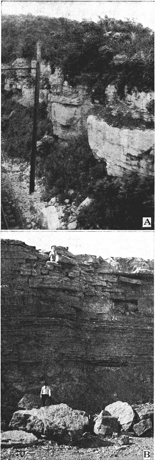
Plate XV--A, Basal members of the Wyandotte limestone, three fourths of a mile west of Argentine station, Kansas City. B, Exposure at quarry about one mile southwest of Loring, Leavenworth county. W, Wyandotte; B, Bonner Springs; P, Plattsburg.
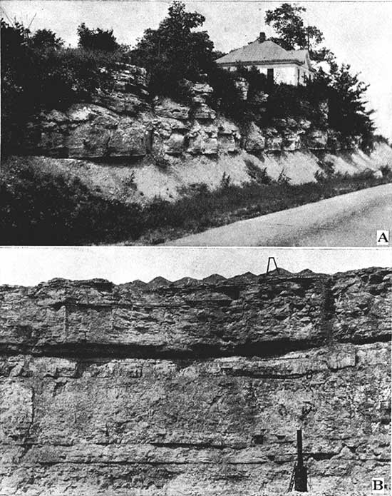
Plate XVI--A, Bonner Springs shale and Plattsburg limestone above, at turn in highway in sec. 8, T. 10 S., R. 23 E. B, Local conglomeratic limestone at the Bonner Springs horizon, one mile west of Bonner Springs.
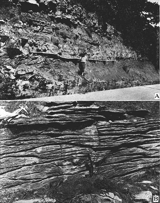
Plate XVII--A, Upper Farley limestone in a road cut one half mile southeast of Pomeroy. B, Stanton limestone, Union Pacific railroad, one half mile east of Linwood, Leavenworth county. C, Captain Creek; E, Eudora; O, Olathe.
Pennsylvanian System
Missouri Series
Bronson Group
The formations of the Bronson group that crop out in Wyandotte County are the Swope limestone, Galesburg shale, and the Dennis limestone. Formations of the Bronson group underlie the entire county, but the beds below the Bethany Falls do not come to the surface within the limits of the county. Exposures of rocks belonging to the Bronson group appear in the bluffs near the confluence of Missouri and Kansas rivers, and in the vicinity of Morris and Edwardsville on Kansas river.
Swope Limestone
The Bethany Falls member of the Swope formation is the oldest stratigraphic unit exposed in Wyandotte County.
Lithologic character and thickness. The Bethany Falls limestone is quite distinct in its lithologic character from the other limestone beds within the county. The limestone is light gray in color, and very massive in fresh exposures, having in the upper part but few bedding planes and vertical joints. Partly because of the massive character it has been found practicable to mine the Bethany Falls limestone, thus saving the cost of stripping the overlying rock. At a quarry east of Morris a few feet of the upper part of the member has been found to be sufficient, with only a few pillars, to support a large thickness of overlying limestone and shaly material. Upon weathering, the upper part of the Bethany Falls limestone breaks up quickly into small fragments. Due to a nodular structure the upper part presents a peculiar spotted appearance. It is generally believed that these nodular masses indicate the work of lime-secreting algae. The complete thickness of the Bethany Falls limestone is not exposed in the county. On weathered slopes 'the massive upper part of the limestone weathers out in large rounded masses that slump down over the underlying strata. The lower part of the formation is not exposed in Wyandotte County, but in adjoining counties it is composed of even-bedded, gray or buff limestone.
A generalized section at Kansas City, Mo., by Hinds and Greene is as follows [S. Hinds, Henry, and Greene, F. C., Stratigraphy of the Pennsylvanian series in Missouri: Missouri Bur. Geology and Mines, vol. 13, 2d ser., p. 124, 1915.]:
| Feet | |
|---|---|
| Limestone, nodular, shelly | 2-4 |
| Limestone, oolitic | 1 |
| Limestone, grayish; upper six feet mottled, lower crystalline, fine-grained | 18-21 |
| Total thickness of Bethany Falls | 21-26 |
Distribution. The Bethany Falls is exposed at only a few places in Wyandotte County. The member appears above the flood plain on the south side of Kansas river a short distance west of Morris, and it is well-exposed in the quarry just east of that town. It is exposed at this place by a structural "high" and dips below the flood plain about a mile west of Turner not to reappear until a point is reached a short distance above Argentine. The limestone is not seen above the flood plain on the north side of Kansas river or at any other place within the county.
Detailed sections. For sections of the Bethany Falls see localities 1, 2, 7, at the end of the report.
Galesburg Shale
The term Galesburg has commonly been used in the Kansas City region for a thin shale separating the Bethany Falls from the Winterset limestone. Much of this shale interval consists of black fissile shale, but the lower five feet or so is gray or buff and argillaceous. J. M. Jewett has found that the typical Galesburg shale at Galesburg, Kan., is the correlative of the five-foot shale above the Bethany Falls limestone at Kansas City. The overlying black fissile shale is regarded as a member of the Dennis limestone.
Lithologic character and thickness. Wherever the Galesburg is exposed in Wyandotte County and adjacent areas it consists of gray to buff argillaceous shale. The thickness ranges from four to six feet.
Distribution. The outcrop of the Galesburg is coextensive with that of the Bethany Falls limestone, cropping out in the south bluff of Kansas river from Morris to a point along the railroad track about a mile west of Turner, and again from a short distance west of Argentine eastward beyond the limits of the county.
Detailed sections. Sections of the Galesburg are given under localities 1, 2, and 7 at the end of the report.
Dennis Limestone
In recent years the Dennis limestone of the old Kansas Survey has been correlated with the previously named Winterset. Investigations by J. M. Jewett have shown that there are two limestones at Dennis, separated by a thin black shale. The latter was traced northward and found to be the black shale commonly correlated with part of the Galesburg in the Kansas City area. It is undesirable to redefine the term Winterset to include strata other than the limestone that has so long been called Winterset. Furthermore, the basal limestone at Dennis does not extend into northeastern Kansas and forms no part of the typical Winterset. The basal limestone is a distinct unit of the cyclic succession of strata that characterizes the main limestone formations in this part of the Pennsylvanian section.
In northeastern Kansas the Dennis formation thus consists of two members, the black Shark shale below, and the Winterset limestone above.
Lithologic character and thickness. The Stark shale consists in Wyandotte County of two parts, the lower half being black, fissile shale and the upper part gray or buff, argillaceous shale. The member ranges in thickness from two to four feet. The black, fissile layer is uniform in thickness and generally measures about a foot in thickness.
The Winterset is characterized by a persistent zone of flint nodules in the upper part. Wherever the upper part of the member is exposed in the county the flint is predominantly black or bluish in color with occasional streaks of white chert. No other limestone in the area contains flint of this color. In the main, the member is argillaceous, drab or bluish-dove in color, and contains a shaly zone near the middle. At some places, such as Morris, the shale in the Winterset is black and platy. At a few places the limestone below the shale parting was observed to be granular and cross-bedded at the top. The upper part of the Winterset is thin-bedded and flaggy whereas the lower part is massive and generally light gray. The thickness of the Winterset member in Wyandotte County is about thirty feet.
Distribution. The Dennis limestone is exposed only along the lower part of the river bluffs and in the larger valleys in the eastern part of the county. The formation rises above the flood plain of Missouri river a short distance above the Kansas City, Kan., waterworks. In Kansas City, Kan., along the Missouri, the formation is covered by a thick mantle of loess. On Kansas river on the north side, the upper part of the Winterset member can be seen along the base of the bluff from Eighteenth street to City Park and again near the interurban stop of Serridge. The farthest extension to the west, on the north side of the river, is at the bridge over Mill creek at the town of Muncie. At this place the cherty upper part has been removed by erosion, and the lower portion of the Winterset rests upon the slaty Stark shale. Very probably the Dennis dips to the . east for a short distance from here, as it does on the south side of the river. The formation first appears above the flood plain on the south side of Kansas river a short distance above Morris where it rises rapidly and dips again abruptly to the east for a short distance before reaching Turner. It is again well above the flood plain at Argentine. The upper part of the Winterset is well-exposed at many places along Turkey creek, extending beyond the county line to the south.
At many places, as along Turkey creek, the Winterset is very fossiliferous, bearing an interesting molluscan fauna near the top. From this zone extensive collections, including an interesting group of nautiloids, have been made in the past.
Detailed sections. For sections containing the Dennis formations see numbers 1, 2, and 7 at the end of the report.
Kansas City Group
The Kansas City group, according to the present classification, includes the Fontana shale, Block limestone, Wea shale, Westerville limestone, Quivira shale, Drum limestone, Chanute shale, Iola limestone, Lane shale, Wyandotte limestone, and Bonner Springs shale. The group includes the upper part of the Kansas City formation of authors, and the lower part of the old Lansing group.
It has been shown elsewhere that the so-called Cherryvale shale of the Kansas City region constitutes only the lower part of the true Cherryvale shale, and that the typical Cherryvale shale is the correlative of strata between the Winterset and the limestone generally called Cement City in the Kansas City section. [Newell, N. D., The stratigraphy of Johnson and Miami counties, Kansas: Kansas Geological Survey, Bulletin 21, Part 1, p. 34.] These divisions have about the same distribution in Wyandotte County, so that a single paragraph will be devoted to the discussion of their areal extent.
Fontana Shale
At the type locality near Fontana, Miami County, the Fontana shale consists of fourteen feet of argillaceous, bluish shale. In Wyandotte County, however, the shale is generally buff and somewhat calcareous. A persistent zone of Chonetina plebeia occurs at the very top of the member. The thickness is not constant in Wyandotte County, ranging from less than two to over six feet.
Block Limestone
The Block limestone in Wyandotte County consists of two or more thin beds of soft, buff limestone, with intercalated layers of buff, limy shale. The thickness of the formation is about six or seven feet.
Wea Shale
The Wea shale ranges from about five to fifteen feet in Wyandotte County. Generally it consists of buff or gray argillaceous shale. The formation is generally not very fossiliferous.
Westerville Limestone
The Westerville limestone, which has been erroneously correlated with the Drum limestone of southeastern Kansas, is equivalent to part of the type Cherryvale shale. The limestone in northwestern Missouri that has been called Drum was correlated with the Dekalb of Iowa by Tilton [Tilton, J. L., The Missouri series in southwestern Iowa: Iowa Geol. Survey, vol. 29, pp. 230, 231, 1920.] and by Condra, [Condra, G. E., The stratigraphy of the Pennsylvanian system in Nebraska: Nebraska Geol. Survey, 2d ser., Bull. 1, p. 29, 1927.] but recently Moore, Condra, and Greene determined that the DeKalb is the same as the type Winterset and Bain's term Westerville should be employed for the unit at Kansas City that has for so long been called Drum. Field work by N. D. Newell has shown that this unit is replaced by shale a mile or so southeast of Martin City, Mo., and for many miles to the southwest does not reappear. On the other hand, the overlying Cement City of Missouri geologists continues somewhat diminished in thickness to Drum creek in Montgomery County, Kansas.
The Westerville limestone in Wyandotte County is characteristically a massive, drab limestone with a thin oolitic layer near the top, above which occurs a lenticularly bedded chert bed composed of irregular layers of pinkish and brown chert. A good exposure of characteristic Westerville limestone occurs along the highway at the bluffs of Kansas river for a mile west of City Park, Kansas City, Kan. The Westerville is variable in its characteristics. At the county line below the pavement east of Holliday the upper part of the Westerville is shaly, while the lower six feet is a massive, suboolitic and fossiliferous limestone. The same is true at the quarry just east of Morris on the south side of Kansas river. A determination of the upper contact was possible by the distinctive character of the overlying Quivira shale. A half mile west of Turner, on the bluff along the railroad tracks, the entire Westerville is a strongly cross-bedded and oolitic limestone bearing a prolific molluscan fauna. The thickness at this place is from eighteen to twenty feet.
Quivira Shale
The Quivira shale member, named after Quivira Lake Resort near Holliday, consists of unfossiliferous, dark or olive-green argillaceous shale, generally with a thin layer of black, platy shale near the middle. It commonly has a thickness ranging between three and seven feet, and is generally unfossiliferous. It is well-exposed above the Westerville limestone in a cut along the interurban about a mile east of Edwardsville north of the concrete highway. At a road cut along Kansas river a mile west of City Park this member is carbonaceous, almost black to greenish, and has a thickness of three feet. At the quarry east of Morris the Quivira has a thickness of about four feet and retains its peculiar greenish tint, being somewhat darker at the middle. Beneath the dam at Forest Lake near Edwardsville the shale is poorly exposed, but appears to be nearly seven feet thick.
Distribution. The beds between the Winterset and Drum limestones crop out along Missouri river to a point beyond Nearman, extending a short distance up all of the tributary valleys. On Kansas river they extend to Forest Lake on the north side of the river where the upper part of the section is exposed beneath the dam. Because of the loess cover on the north side of Kansas river, good exposures of these beds in the western and central parts of the county are scarce. Good outcrops of them are more abundant on the south side of the river, especially between Turner and Holliday. Excellent exposures occur along the interurban track all the way from City Park, Kansas City, Kan., to the station Serridge, some distance to the west.
Detailed sections. Stratigraphic sections containing the formations discussed above may be found under numbers 1, 3, 4, 5, 6, 7, 8, at the end of the report.
Drum Limestone
Lithologic character and thickness. The Drum, for so long known around Kansas City as the Cement City limestone, or the "building ledge" on account of its extensive commercial use, is remarkably uniform in its characteristics. It is everywhere a thin-bedded and wavy-bedded, whitish to gray limestone, rarely cherty in Wyandotte County, commonly assuming an appearance somewhat similar to that of the Argentine limestone. As a rule the formation is not very fossiliferous, but typically contains Marginifera sp. and Campophyllum torquium, and usually has a zone of Composita subtilita? and ramose bryozoans in the shaly layer at the top. The formation is generally about ten feet thick. Locally there is a thin oolitic or granular layer at the top. R. C. Moore has used the term Corbin City for this layer and retains the term Cement City for the main part of the formation.
Distribution. The Drum is exposed in the road cut along the bluff of Kansas river along the south edge of sec. 12, T. 11 S., R. 24 E.; also at the quarry east of Morris, at the dam level at Forest Lake, at City Park, and numerous other places.
Detailed sections. The Drum limestone is given in sections 1, 3, 6, 7, 8, given at the last part of the report.
Chanute Shale
This unit, lying below the Iola and above the Drum, constitutes the Chanute shale. This is the same as the lower part of the "middle Chanute" of Missouri geologists.
Lithologic character and thickness. The Chanute shale in Wyandotte County is typically argillaceous, buff to gray and commonly barren of fossils. Near the middle of the formation there locally occurs a thin band of maroon clay shale. This layer has been noted at several places in Missouri by Hinds and Greene. [Hinds, Henry, and Greene, F. C., The stratigraphy of the Pennsylvanian series in Missouri: Missouri Bur. Geology and Mines, vol. 13, p. 118, 1915.] The formation ranges from about nine to thirteen feet. At the top of the formation there occurs locally the northern extension of the Thayer coal, as in sec. 12, T. 11 S., R. 24 E.
Distribution. Good exposures of the Chanute shale are not common in Wyandotte County, the best being along the south edge of sec. 12, T. 11 S., R. 24 E. The Chanute extends up Missouri river approximately to Pomeroy and occurs in the river bluffs to Kansas City. On Kansas river the formation remains above the flood plain as far west as Bonner Springs.
Detailed sections. Sect.ions of the Chanute are given under numbers 1, 3, 7, 8, in the register of localities at the end of this report.
Iola Limestone
It has been demonstrated that the Raytown limestone of the Kansas City region constitutes the upper and main part of the Iola limestone. [Newell, N. D., The stratigraphy of Johnson and Miami counties, Kansas: Kansas Geological Survey, Bulletin 21, Part 1, p. 51.] In northeastern Kansas the black shale and blocky limest.one just underneath the Raytown represents the lower and less conspicuous part of the formation.
The Iola has been divided into three members, in ascending order, Paola limestone, Muncie Creek shale, and Raytown limestone.
Lithologic character and thickness. The Paola member consists in Wyandotte County of a single layer, rarely more, of dense, dark bluish-gray, blocky limestone. It is generally about a foot thick. This member is characterized by abundant stringers and coils of parallel-banded markings or "marklets" of calcite. These are possibly deposits formed by calcareous algae.
The Muncie Creek shale member consists principally of black fissile shale with a thin layer of gray or buff shale above and below. At the top of the member occurs a zone of spherical and elongate gray, phosphatic concretions, some of which contain shark teeth or the conularid, Conularid crustula. This zone of concretions is the most constant feature of the entire Iola formation in Kansas, having been observed by Newell as far south as the Kansas-Oklahoma line. The Muncie Creek is commonly about three feet thick in Wyandotte County.
The Raytown member is a massive bed of gray to brownish limestone which commonly weathers buff, light gray, or brown. This is the bed known locally in Kansas City as the "Calico ledge," so-called because of the mottled appearance of the rock. The presence of numerous fossils, chiefly large brachiopods, and the brecciated character of the rock produce a characteristic spotted appearance in both weathered and fresh exposures. The thickness of the unit in the county is about five feet. The bedding is characteristically even, the layers commonly attaining a thickness of about a foot.
Distribution. Good exposures of the Iola are not common. The best outcrops occur at the fine exposure along the south side of sec. 12, T. 11 S., R. 24 E. The Iola extends up Missouri river nearly to Wolcott before it dips below the flood plain. It occurs high in the bluff at Kansas City. Along Kansas river the formation extends nearly as far as Bonner Springs. On the south side of the river the Iola appears in the bluff all the way to Cedar creek in Johnson County, where it is well exposed along the railroad track just east of the mouth of the creek. The Iola extends well into Johnson County along Turkey creek and is exposed at a number of places in the bluff about Southwest Boulevard. The formation extends well up the tributary valleys in the eastern part of the county and commonly fo~ms a minor bench in the valley walls.
Detailed sections. Stratigraphic sections of the Iola are given under localities 1, 3, 7, 8, at the end of the report.
Lane Shale
Lithologic character and thickness. The Lane shale, equivalent to the "upper Chanute" of the Missouri geologists, is a bluish or buff argillaceous shale. The thickness is rather irregular, ranging between twenty and thirty-eight feet. This formation has yielded a remarkable fauna of crinoids at localities in Kansas City, Mo., where twenty-five or more species have been found, in addition to other fossil invertebrates. In Wyandotte County, however, the formation seems to be rather barren of fossils at the few places where it is well-exposed. The outcrop of the Lane may be considered as being approximately coextensive with that of the Argentine limestone above.
Distribution. The Lane extends up Missouri river valley from Kansas City nearly to Wolcott before dipping beneath the flood plain. Along Kansas river the formation extends to Loring on the north side of the river and to Corliss on the south side. In the eastern part of the county and along Turkey creek the Lane extends far up each tributary valley.
Detailed sections. Sections of the Lane are included under sections 1, 3, 7, 8, in the register at the end of the report.
Wyandotte Limestone
The Wyandotte limestone is treated as a formation, because in much of eastern Kansas its subdivisions form a single indivisible limestone unit. The members of the Wyandotte, in ascending order, are: Frisbie, Quindaro, Argentine, Island Creek, and Farley. The Frisbie, Quindaro, and Argentine constitute the unit that has for so long been called the Iola limestone in the Kansas City region.
Lithologic character and thickness. The lowermost member of the Wyandotte limestone is the Frisbie limestone. In Wyandotte County it consists generally of a single layer of fine-grained, bluish-gray limestone. As a rule the unit is quite even-bedded. Commonly the member is from one to two feet thick.
The next member, in ascending order, is the Quindaro, consisting of a few inches to four feet of shale. Where the member is thin it consists of buff calcareous shale, and where thick of greenish clay shale.
The Argentine limestone member is one of the most easily recognizable formations in Wyandotte County. The member is a thin-bedded, whitish or gray to pinkish, cherty and rather crystalline limestone. The bedding is generally somewhat irregular and wavy. In the most characteristic development it is buff and shaly at the base. Generally the abundant gray and brown chert is concentrated in the form of nodules in the upper part of the member. The thickness is not the same throughout the county, but everywhere the Argentine is one of the thickest limestones exposed in the area. The member is generally about twenty-eight feet thick, although it ranges from about twenty-two to thirty feet.
The Island Creek shale, which lies between the Argentine and Farley limestones, has in Wyandotte County rather a wide range in thickness. The type exposure of the member occurs at the quarry in the NW cor. sec. 11, T. 10 S., R. 23 E. Along the concrete highway a quarter of a mile southeast of Wolcott near the south side of section 12, where the Argentine and Farley are both well-exposed, the Island Creek has a thickness of forty-three feet. Southward to Bonner Springs the member thins rather uniformly. At a point north of the middle of the east edge of sec. 25, T. 10 S., R. 23 E., on the concrete highway, the member is fifteen and one half feet thick. In the quarry on the high hill southeast of Twenty-sixth and Metropolitan Ave., Argentine, the member has a thickness of seven and one half feet. At Forest Lake, west of the dam near Edwardsville, the bed is six and one half feet thick. In a road cut about a mile east of Bonner Springs on the road leading to a camp of the Boy Scouts of America, the Island Creek shows a local thickening to thirteen feet, while a short distance to the west, at the cement plant, the shale has dwindled to about a foot. The member is also quite thin at the quarry of the Union Pacific railway west of Loring. The member is quite thin in Johnson County, but it is easily recognizable as far south as the Miami County line.
The Farley limestone attains an important development in Wyandotte County. A general lack of recognition of this member has caused considerable confusion in the past. In much of Wyandotte County the Farley consists of two distinct limestone units separated by a fairly prominent shale. The lower limestone of the Farley is fairly constant in lithologic character, but has a considerable range in thickness. It is, in the main, a massive, cross-bedded, oolitic, and fossiliferous limestone. In color the unit is commonly brown or drab. Curiously, in spite of the great thickness attained in some places by this bed, it is broken up by the processes of weathering so that it is not commonly seen in natural exposures and in some cases leaves but a slight terrace to show its position, while the Argentine below stands out in bold relief, producing a prominent bench. At those places where the lower Farley is exposed, notably near Wolcott, it seldom shows any joints whatever. In common with many other oolites of the region, the fauna is chiefly molluscan with a good representation of bryozoans and brachiopods, however. Of notable interest is the cephalopod fauna to the south in Johnson County, where, near De Soto, a great many species are assembled together within a small area.
Near Wolcott the lower Farley reaches a maximum development, the greatest thickness noted being at a good exposure of the bed on Island creek at the center of section 23, T. 10 S., R. 23 E. At this place the unit is about thirty feet thick. At a quarry near the concrete highway at the northwest corner of section 11, T. 10 S., R. 23 E., the bed is fifteen feet thick. A fourth of a mile southeast of Wolcott by the highway a thickness of sixteen feet was measured. At the fork in the road just south of Pomeroy the lower Farley is eight feet thick, and is even thinner northeast of Welborn. At the quarry above Argentine, near Twenty-sixth and Metropolitan avenue, it is thirteen and one half feet thick. West of the dam at Forest Lake near Edwardsville the lower sixteen feet of the Farley is believed to represent the lower Farley bed. West of this exposure along Kansas river it is impractical to try to differentiate the parts of the Farley in Wyandotte County.
The middle Farley is usually a calcareous or argillaceous gray to buff shale. In thickness it is rather constant in the northern part of the county, ranging between about seven and twelve feet. At Argentine this bed has a thickness of ten feet. From Forest Lake to Loring along Kansas river the unit is barely distinguishable, the two limestone beds having been brought together. At many places this shale bed was observed to be replete with a species of Myalina, bearing practically no other fossils.
The upper Farley limestone is characteristically a massive, hard, dark limestone, bearing but few fossils. Where the bed coalesces with the one below, it takes on a drab, granular appearance. At exposures near Wolcott the upper Farley is about two feet thick, increasing to three and one half feet south of Pomeroy and about the same at Argentine. At Forest Lake the upper twelve feet of the Farley is believed to represent the upper Farley bed and at the cement plant quarry near Bonner Springs the upper eleven feet.
Distribution. The Wyandotte formation is widely distributed in Wyandotte County. Throughout the eastern part of the county the formation caps most of the hills and directly underlies the upland surface, covered often with a layer of loess and glacial drift. Generally the hard layers at the top of the Argentine form a prominent bench plainly visible in the valley walls of the rivers and smaller streams. The Wyandotte crops out up the Missouri valley as far as Wolcott. Between Nearman and Quindaro it is well-exposed in quarries along the river bluff. In Kansas City, Kan., and along Turkey creek the formation is well shown in numerous quarries and road cuts. Along Kansas river it extends to a point just west of the mouth of Kill creek in Johnson County and on the north side to a point opposite De Soto.
Detailed sections. Sections of the Wyandotte are shown under numbers 1, 7, 8, 9, 10, 11, 12, 13, 14, 15, 16, 17, 18, 19, 20, at the end of the report.
Bonner Springs Shale
This formation, the so-called "upper Lane" of the Kansas City region, is typically exposed at the cement plant quarry near Bonner Springs. It is highly irregular in Wyandotte County, but can generally be identified with little difficulty.
Lithologic character and thickness. From the absence of marine fossils, except near the top, and the abundance locally of Cordaites and other plant forms, attended by a predominantly arenaceous character in Wyandotte County, it may be supposed that the Bonner Springs shale is a near-shore deposit. Near the top of the formation occurs a thin layer of maroon shale, which is persistent over a large area in Missouri and Kansas. Locally this maroon layer is absent, apparently having been removed by erosion near the end of Bonner Springs time. At the cement plant quarry near Bonner Springs and at other places the disconformable contact between the partially removed maroon shale and an overlying sandstone was recognized. At the county line a mile west of Bonner Springs this thick shale formation has been entirely removed by erosion before deposition of later deposits. At this locality the upper part of the Farley is directly overlain by a cross-bedded deposit of shell fragments and limestone pebbles, overlain in turn by the Plattsburg. At Loring, in the face of the quarry, the Bonner Springs is represented by a few inches of shale. The cross-bedded layer was not recognized at Loring, but it is well-developed at De Soto, where it is predominantly a limestone conglomerate. The abrupt lensing out of the Bonner Springs takes place in a narrow band which extends southwest by northeast, paralleling the course of Kansas river between Bonner Springs and De Soto by way of Loring, but restricted wholly to the west side of the valley, and crossing the river opposite De Soto. In a line parallel to the river, but on the east side of the valley between the cement plant quarry at Bonner Springs and the east bluff of Kill creek at De Soto, by way of the east and south bluff of the river, the Bonner Springs shale retains its normal characters. Apparently this abrupt thinning of the shale, together with the occurrence of a limestone conglomerate, indicates a local disconformity. Very probably the course of the river at this place is partly controlled by the thinning of the Bonner Springs, since the removal of the shale formation in the west bluff of the river has left nearly a hundred feet of limestone with but little included shale. In passing, it is of interest to note that the great thickness of limestone, including the Wyandotte and the Plattsburg, has in this part of the river's course resulted in the valley being unusually narrow.
The Bonner Springs is thickest in the northern part of Wyandotte County and thins regularly toward the south. At the east fork in the road leading southward out of Pomeroy the formation is thirty-eight feet thick, argillaceous below and arenaceous above, with a gray to buff color. In exposures near Wolcott the formation contains some sandstone, as it does northeast of Welborn, resembling in places the cross-bedded sandstone of the Stranger formation. This resemblance is somewhat heightened at. the latter locality by an included conglomeratic bed at the top of the Farley, the latter being quite thin at this place. At Argentine the Bonner Springs is thirty-three feet thick, thinning westward to twenty-four feet at Bonner Springs, where the formation is dominantly gray and somewhat arenaceous.
Distribution. The Bonner Springs crops out along all of the larger valleys in the western half of the county. In the eastern part the formation has been generally stripped away by erosion. In a few places, however, as at Argentine, the entire thickness of the formation is preserved.
Detailed sections. Sections of the Bonner Springs are given under numbers 7, 8,12, 13, 14, 15, 16, 17, 18, 19, at the end of this report.
Lansing Group
Plattsburg Limestone
Field work by Newell throughout the Plattsburg outcrop in Kansas has shown the desirability of a three-fold division of the formation into members. The members are called Merriam limestone, Hickory Creek shale, and Spring Hill limestone.
Lithologic character and thickness. The Plattsburg is one of the best key horizons in the northeastern part of the state. Over large areas in this region persistent lithologic and faunal peculiarities appear in the formation. In all parts of Wyandotte County the Plattsburg is evenly bedded, containing thicker beds above and below the middle.
The lower member, the Merriam limestone, consists of two or three blocky, even beds or gray or bluish-gray limestone. In parts of the county these layers are utilized for building stone of high quality. The entire member ranges generally between two and three feet in thickness. Commonly the lower beds are largely composed of the ellipsoidal algal remains of Osagia, which resemble in section large compressed oolite grains, differing in that they occur in brittle limestone, breaking through the grains rather than around them as generally is the case in oolitic limestones. This layer always bears a rich molluscan fauna in which Myalina subquadrata is the dominant form. The upper layer or layers of the member are dense, hard beds, relatively unfossiliferous. The upper of these commonly bears abundant large iron-stained tubes resembling the borings of some organism.
Separating the Merriam from the upper and main part of the Plattsburg is the thin Hickory Creek shale. This member is quite thin, ranging generally between three and twelve inches or so. Where the shale is thin it is carbonaceous and platy, especially in the northern part of the county. Where it is thicker the member is generally argillaceous or brown and limy, with small, brown calcareous nodules.
The upper Plattsburg, called the Spring Hill limestone member, weathers characteristically light brown or yellowish. The surface color carries deeply into the large blocks that have been long exposed to weathering. Near the base of the member occurs a layer of hard, gray limestone that bears Marginifera wabashensis and an occasional specimen of Enteletes hemiplicatus var. plattsburgensis. The remainder of the Spring Hill owes its characteristic color to the oxidation of the highly impure limestone. In fresh exposures the limestone generally presents a grayish, argillaceous and granular appearance. Generally the member is somewhat shaly toward the middle and is locally cherty. Generally silicified specimens cf Heliospongia ramosa are associated with the chert nodules. A very slender variety of Triticites irregularis characterizes the Spring Hill This little fusulinid is readily distinguished in the field from the more robust variety. of this species that occurs in the Stanton. Particularly abundant in the Spring Hill are the spines of a species of the echinoid Echinocrinus; also the calices of a species of Delocrinus are common. As a rule the member ranges between ten and fourteen feet, although locally, as at the road cut along the highway a mile west of Bonner Springs, it may be somewhat thinner than this.
Distribution. The Plattsburg crops out widely in the western three fourths of Wyandotte County, where it is exposed in all of the larger valleys. The most eastern exposure of the formation in the county occurs south of Kansas river, at Argentine. The eastward extent of the Plattsburg should be looked upon as the continuation of the Plattsburg-Stanton escarpment which crosses into Wyandotte County from the south near the southeast corner. The high degree of dissection and the thick covering of loess and till contribute to effectively efface any distinct Plattsburg-Stanton escarpment which may have formerly existed in the county.
Detailed sections. Sections of the Plattsburg formation are given under numbers 7, 12, 13, 14, 15, 16, 18, 19, 25 at the end of the report.
Vilas Shale
In Wyandotte County the Vilas is quite uniform in its characters and may be recognized easily. This is the same formation that has long been known as the Vilas shale in northeastern Kansas. Newell has verified this correlation by tracing the formation from its type locally in southeastern Kansas.
Lithologic character and thickness. Throughout Wyandotte County the Vilas is a more or less arenaceous shale, bluish-gray in the northern part of the county and light-buff over most of the remaining part of the area. The thickness ranges from sixteen to thirty feet, being thickest in the western part of the county. A persistent layer of calcareous sandstone a foot or so thick occurs near the top of the formation.
Distribution. The outcrop of the Vilas is confined chiefly to the uplands in the western part of the county, extending as a thin band between the outcrop of the Plattsburg and Stanton.
Detailed sections. Stratigraphic sections of the Vilas are shown under localities 13, 15, 21, 23, 25, and 26, at the end of the report.
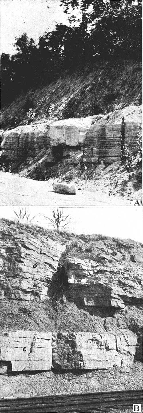
Stanton Limestone
Five members of the Stanton formation are recognized in Wyandotte County. They are, in ascending order: Captain Creek limestone, Eudora shale, Olathe limestone, Victory Junction shale, and Little Kaw limestone.
Lithologic character and thickness. The Captain Creek limestone member is probably the most uniform in character of any unit exposed in Wyandotte County. It is a massive, gray limestone, composed of three or four even layers, which turn light gray to white upon weathering. The limestone is brittle, breaking up into small, angular fragments upon weathering. Markings occur in the form of small concentrically banded growths like those found in the Paola member of the Iola. The limestone is commonly dense or fine-grained, but in some places is crystalline. Everywhere in the county the Captain Creek limestone is about five and one half feet thick.
The Eudora shale member is quite characteristic. The upper and lower parts are generally composed of buff or gray, argillaceous shale, separated by about a foot of platy, black shale. The member is uniformly about six feet thick. The Eudora is characteristically devoid of fossils.
The Olathe member is composed of thin-bedded and wavy, gray, granular and crystalline limestone. The member is comparatively uniform throughout the county. In a few instances, as at Victory Junction, the member appears massive and thick-bedded. Such instances are generally found at artificial exposures where the rocks have not long been weathered. In natural exposures the Olathe is commonly the only member of the Stanton to be seen, on account of its thickness and relative resistance to erosion. The member is generally about twelve feet thick.
The Victory Junction member is generally made up of buff to light-gray shale, argillaceous in the north and arenaceous in the southern part of the county, where it contains some sandstone in the upper part. The thickness of the member ranges from seven feet along the northern edge of the county to about ten feet farther south.
The Little Kaw Limestone is quite irregular in Wyandotte County. Generally, however, the lower layers are buff, arenaceous limestone, and the upper part is composed of blocky, even beds of dark gray, brittle limestone. The thickness of the member ranges from one to four feet. The Little Kaw member is commonly overlain by an irregular layer of limestone conglomerate, in places separated from the limestone below by a thin parting of shale. The conglomerate is the basal bed of the Virgil series.
Distribution. The Stanton formation is exposed only in the western part of the county where it underlies most of the flat upland plain.
Detailed sections. Sections of the Stanton limestone are given under numbers 15, 21, 22, 23, and 26 at the end of the report.
Virgil Series
Stranger Sandstone
The lower part of the Stranger sandstone is the highest indurated deposit in Wyandotte County. The formation unconformably overlies various parts of the Stanton, generally the Little Kaw limestone member.
Lithologic character. In Wyandotte County the Stranger consists of soft, buff, cross-bedded sandstone which weathers in massive rounded slopes. At some localities thin coal beds occur between layers of sandy shale. Exposures were too poor to enable us to determine whether or not any of the coal beds are persistent. Generally the sandstone overlies a thin layer of hard limestone conglomerate, which in turn directly and evenly overlies the little Kaw limestone. Locally more than one conglomerate bed occurs near the base of the Stranger. In section 8, township 10 south, range 23 east, near the middle of the south edge there is a thin bed of limestone overlying the Vilas shale. This limestone probably is the lower part of the Captain Creek. It is overlain by a conglomerate bed followed by a sandstone succession containing thin coal beds. This is the only known occurrence in Wyandotte County where the basal beds of the Virgil cut down into the Stanton. The original thickness of the Stranger in Wyandotte County is unknown, since the upper part has been removed from the area by erosion. It is probable that at least forty or fifty feet of the formation still occurs in the upland area in the western part of the county.
Distribution. The sandy deposits of the Stranger cover the upland plain and stream divides in the western and central part of the county.
Detailed sections. Sections of the basal Stranger are given under numbers 15, 22, 23, 24, 25, and 27, at the end of this report.
Quaternary System
Pleistocene Deposits
The oldest deposits of Pleistocene age recognized in Wyandotte County are isolated remnants of till of Kansan age occurring in places on the hilltops. These deposits are rare and consist of a heterogeneous association of erratics, worn boulders of local limestone, and sand. The foreign boulders and pebbles consist mainly of Sioux quartzite, with numerous granites and metamorphic rocks. Many of the latter are in an excellent state of preservation, although crumbling igneous erratics are not uncommon in the area. It is possible that these partially decomposed boulders were derived from an earlier stage of glaciation, and later included in the Kansan drift. Numerous localities occur within the county where excellently preserved glacial striae occur at the surface of limestone beds. In appearance, the planation and scratching of the limestone is as fresh as though produced during a late stage rather than the Kansan stage of the Pleistocene. At the quarry of the Union Pacific Railway just west of Loring well preserved striae occur beneath stratified drift. The striae occur in two sets, equally distinct in the limestone, one of which has a bearing of S. 10° E. and the other S. 34° E. to S. 42° E., showing two directions of ice advance. At this place the striated rock with the overlying drift occurs at a comparatively low place in the valley wall, since bedrock rises immediately to the west above this horizon. The bearing of the striae need not necessarily be the same as the general movement of the ice, since irregularities in the land surface affect the direction of movement. At the county line on the highway one mile west of Bonner Springs, numerous striated blocks of the upper layer of the Plattsburg have been taken from the road cut. This is the same stratigraphic horizon at which the striae occur at Loring, and likewise the striae are bounded immediately to the west by topographically higher hardrock formations. Unfortunately, the blocks have been moved so that a reading of the bearing of the striae could not be obtained at this place. A large area of beautifully preserved striae has been exposed at the surface of the Raytown near the interurban stop of Serridge, in the SW cor. of sec. 12, T. 11 S., R. 24 E., as a result of extensive road excavations along the Muncie bluffs. The striated blocks were piled along the interurban track, where hundreds of square yards of polished surface could have been studied. The striae at this locality occur at a low point on the east side of the valley of Muncie creek. At Boynes quarry northeast of Welborn on the bluff of Missouri river a considerable area of striated limestone has been uncovered at the top of the quarry. As in the other cases the scratches occur at a point topographically below bed rock in the surrounding hills. The striae at this place for the most part have a bearing of about S. 5° E.
At each of the localities cited the striated rock is overlain by drift which has been to a greater or less extent worn by the action of water. It is probable that these deposits represent outwash from the melting glacier. It may be noted that the topographically low position of the glacial striae along Kansas river points to the fact that Kansas river drainage had been established before the ice advance.
The youngest deposits of probable Pleistocene age include the widespread loess. This material is peculiar in its tendency to stand in vertical walls. The loess of this area commonly contains a high percentage of fine sand. The loess covering is thickest along the edge of the bluff of Missouri river where in some places it attains a thickness of more than fifty feet. Back from the river a short distance it quickly thins out, becoming indistinguishable from the soil covering. On Kansas river the loess is absent between Edwardsville and Bonner Springs on the north side of the river, probably having been removed here by erosion, because the loess is continuous along the south wall of the valley. South of Bonner Springs loess covers the indurated formations to Loring and beyond. The eastern part of the county is covered by an irregular layer of loess, effectively hiding the underlying formations in the vicinity of Kansas City. The loess commonly has a brown to slightly reddish color, while the loess along Missouri river is usually light buff to grayish. It is generally believed that the loess of this region has been derived from the river silt of the valley bottoms, deposited by the overloaded streams during the ice retreat and later blown by the wind onto the neighboring uplands.
Recent Deposits
The Recent deposits of Wyandotte County consist of (1) obscure alluvial terraces along some of the tributaries of the Kansas, (2) residual soil, (3) wash deposits, and (4) flood-plain deposits. Residual soil of a region is formed by the processes of weathering on the rocks. In Wyandotte County thin deposits of residual soil occur over part of the upland area, but are of small areal importance. The colluvial or slope wash deposits likewise constitute but a small part of the Recent deposits. By far the greater part of the Recent deposits in the area include the alluvium of the river flood plains and the flood plains of the principal tributaries. This is accumulating rapidly in the valleys of the Missouri, which is aggrading its channel. According to Hinds and Greene the valley filling of the Missouri at Quindaro extends to a depth of 107 feet before bedrock is reached. [Hinds, Henry, and Greene, F. C., The Leavenworth-Smithville folio: U. S. Geol. Survey, p. 8, 1917.] The valley filling, however, is not all of Recent age, since the aggrading of the channel probably started before Pleistocene time. The valley deposits of Kansas river are much the same as those of the Missouri. Undoubtedly the cultivation of the soil in eastern Kansas has resulted in a great amount of loess and soil being dumped into the streams. By breaking the sod the surface runoff of the water is greatly increased, producing intensive gullying which is frequently seen in this area. Since the Missouri throughout its course extends through a greater amount of loess-covered territory than the Kansas, it receives a much greater amount of this soft material than the latter stream.
Prev Page--Geography || Next Page--Structural Geology
Kansas Geological Survey, Geology
Placed on web Feb. 25, 2014; originally published May 1935.
Comments to webadmin@kgs.ku.edu
The URL for this page is http://www.kgs.ku.edu/General/Geology/Wyandotte/03_strat.html