![]()
Prev Page--Contents || Next Page--Geography
Introduction
Purpose and Scope of the Investigation
An investigation of the geology and ground-water resources of Sheridan County was begun in 1952 as a part of the program of ground-water studies in Kansas by the United States Geological Survey and the State Geological Survey of Kansas, with the cooperation of the Division of Sanitation of the State Board of Health and the Division of Water Resources of the State Board of Agriculture. Ground water is one of the principal natural resources of Sheridan County. Nearly all water supplies in the county are obtained from wells. Irrigation has not been practiced extensively in the county, but considerable recent interest has been expressed in irrigation and an adequate understanding of the quantity and quality of ground water available and the measures necessary to safeguard its development and use is needed.
Location and Extent of the Area
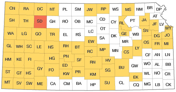
Sheridan County is in the second tier of counties south of the Nebraska border and the third tier of counties east of the Colorado border. Sheridan County is bounded on the east by Graham County, on the north by Decatur County, on the west by Thomas County, and on the south by Gove County. It contains 25 townships and has an area of approximately 893 square miles. Sheridan County and other areas in which cooperative ground-water investigations have been made are shown in Figure 1.
Figure 1--Index map of Kansas showing area described in this report and areas covered by other online geologic reports, as of Feb. 2009. For additional information, please visit the KGS Geologic Maps of Kansas Page.
Previous Investigations
No detailed geologic reports on Sheridan County have been published, but several reports refer to the county either directly or in a general way. Haworth studied the regional geology and water resources of western Kansas in 1895 (Haworth, 1897); Johnson (1901, 1902), in his report on the utilization of the southern High Plains, made special reference to the source, availability, and use of ground water in western Kansas; and Darton (1905) made a study of the geology and ground-water resources of the central Great Plains. The work by Elias (1931) on the geology of Wallace County was an important contribution to the geology of western Kansas in that his studies of the Ogallala formation are probably the most comprehensive and his definition of the Sanborn formation was the foundation for later studies of the Pleistocene deposits in western Kansas. A study of the geology and ground-water resources of Thomas County was made by Frye (1945) and a similar study of Norton and northwestern Phillips counties was made by Frye and Leonard (1949). A report was prepared by Beck and McCormack (1951) on the geologic construction materials in Sheridan County, and is one of a series of similar county reports. A comprehensive study of the Pleistocene geology of Kansas was made by Frye and Leonard (1952). Field studies of the geology and ground-water resources of Decatur, Gove, Graham, and Rawlins counties in northwestern Kansas have been completed and reports are in preparation.
Methods of Investigation
The geology of the area was studied and was mapped on aerial photographs during the summer of 1952 and the data were then transferred to Plate 1 with a Focalmatic projector. The wells listed in Table 7 were visited during the investigation and the depths to water and the depths of the wells were measured with a steel tape from a fixed measuring point near the land surface, generally the top of the casing. The character of the material below the land surface was determined by the drilling of 34 test holes through the Pleistocene and Tertiary deposits to the Cretaceous bedrock. The test holes were drilled with the hydraulic-rotary drilling machine owned by the State Geological Survey of Kansas and operated by N. W. Biegler and W. T. Conner of the State Geological Survey. The altitudes of the wells and test holes were determined by field parties under the direction of W. W. Wilson and Edwin Rhine of the Federal Geological Survey using a plane table and alidade.
Wells shown on Plate 2 were located within the sections by use of an odometer. The figures adjacent to the well locations on Plate 2 refer to the depth of the water below the land surface and brackets around the figures indicate that a chemical analysis is given in Table 3. Samples of water were collected from 18 wells and were analyzed by Howard Stoltenberg, chemist, in the Water and Sewage Laboratory of the Kansas State Board of Health. Base maps of the county were prepared by Bernita Mansfield from maps from the Soil Conservation Service.
Well-numbering System
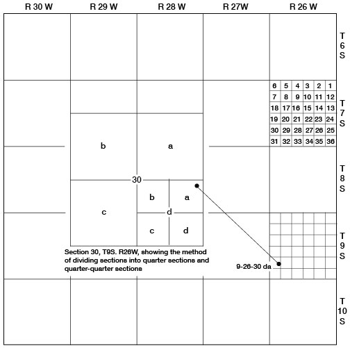
The well and test-hole numbers in this report give the location of the wells and test holes in accordance with the Bureau of Land Management system of land subdivision. The first numeral of a well number indicates the township, the second the range, and the third the section. The quarter sections and quarter-quarter sections are designated a, b, c, or d in a counterclockwise direction beginning in the northeast quarter. For example, well 9-26-30da (Fig. 2) is in the NE SE sec. 30, T. 9 S., R. 26 W. If 2 or more wells are within a 40-acre tract, the wells are numbered serially according to the order in which they were inventoried.
Figure 2--Map of Sheridan County illustrating the well-numbering system used in this report.
Prev Page--Contents || Next Page--Geography
Kansas Geological Survey, Geology
Placed on web Feb. 10, 2009; originally published May 1956.
Comments to webadmin@kgs.ku.edu
The URL for this page is http://www.kgs.ku.edu/General/Geology/Sheridan/02_intro.html