![]()
Prev Page--Recharge, Discharge || Next Page--Quality
Ground Water, continued
Utilization of Water
A large part of the wells in Pawnee and Edwards counties supply water for domestic and stock use. Most of the water used in this area, however, is pumped from the comparatively few irrigation wells. A few wells in this area are used for public-supply and industrial purposes.
Domestic and Stock Wells
Domestic wells supply homes with water for drinking, cooking, rind washing, and supply those schools not served by municipal wells. Stock wells supply water for livestock, principally cattle. Water for domestic use is obtained almost entirely from wells, but in some of the areas of Cretaceous outcrop a few cisterns probably are used. Most of the stock water also is obtained from wells but in recent years there has been an increased construction of dams on dry watercourses in areas where supplies of ground water are difficult to obtain. Although the water generally is hard, it can be used satisfactorily for most domestic and stock purposes.
Public Water Supplies
Larned, Kinsley, Lewis, and Belpre are the only cities in the Pawnee-Edwards area having public water supplies, and they are supplied from wells. Brief descriptions of the water-supply systems of these cities are given below and details of well construction are listed in the well tables at the end of the report.
Larned
The City of Larned is supplied from eight wells (44, 50, 51, 52, 53, 54, 56, and 110), of which six obtain water from the Dakota formation and two obtain water from the alluvium of Arkansas River. The wells that obtain water from the Dakota range in depth from 123 feet to 167 feet and are cased with 10-inch wrought-iron casing. They are equipped with turbine pumps powered by electric motors. The wells each have a 5-inch column pipe and a 4-inch discharge pipe. The depth to water level in each well is reported to be 30 feet.
The two wells that obtain water from alluvium (56 and 110) have a much larger yield. Well 56 is 70 feet deep and has a static water level of about 10 feet. It is 'cased with 19-inch galvanized-iron casing and is equipped with a turbine pump powered by a 100-horsepower electric motor. The well pumps 675 gallons of water a minute into the water system but during an open-flow test it pumped 1,450 gallons a minute with a drawdown of 11 feet after several hours of pumping. The specific capacity of the well, therefore, is 132. Well 110 is a dug well 20 feet in diameter and cased with concrete. Water enters the well by means of 54 screened drive points that extend laterally from the well. The drive points are 6 inches in diameter. The well is 26 feet deep and is equipped with two 5-inch centrifugal pumps powered by 100-horsepower electric motors. Each pump has an open-flow yield of 1,000 gallons a minute but yields 600 gallons a minute when pumping into the mains. The total capacity of the eight wells when pumping into the mains is about 2,775 gallons a minute. The water is pumped directly into the mains; the excess water is stored in an elevated steel tank having a capacity of 500,000 gallons.
The average daily consumption of water in 1943 was 260,000 gallons or 75 gallons per capita. The total amount of water pumped in 1943 was 136,500,000 gallons, of which 95,000,000 gallons was used for domestic purposes, 14,200,000 gallons was used by industries, and 27,300,000 was charged to loss. (This includes water used by fire department, street department, and city parks.)
The ground water used by the City of Larned is hard, but is suitable for most domestic uses (analysis 56, Table 9).
Kinsley
The water supply for Kinsley is obtained from two wells (264 and 265) penetrating the Meade formation in the sand-hills area south of Arkansas River. The wells are in the NW 1/4 sec. 6, T. 25 S., R. 18 W., about 3 miles east-southeast of the city. Well 264 is 86 feet deep and has a static water level of 41 feet, whereas well 265, which is at a lower altitude, is 72 feet deep and has a static water level of 32 feet. Both wells are cased with 18-inch wrought-iron casing and are equipped with turbine pumps powered by 20-horsepower electric motors. The wells are reported to yield about 600 gallons a minute with a drawdown of 15 feet; hence, the specific capacity of each is 40.
The municipal supply formerly was obtained from two shallow wells in the alluvium of Arkansas River at Kinsley, but owing to the considerable hardness of the water a new supply was sought in the sand-hills area where the water is of much better quality. Water from the new wells is pumped into a short pipeline, which carries the water across Arkansas River and connects with the city mains. The excess water is stored in two standpipes having an aggregate capacity of 345,000 gallons, and in one surface reservoir having a capacity of 350,000 gallons. Water is distributed from the standpipes into the mains by the force of gravity, whereas water in the surface reservoir is forced into the mains by means of two centrifugal pumps having capacities of 400 and 600 gallons a minute, respectively.
The ground water used by the City of Kinsley is relatively soft, as indicated by analysis 265 in Table 10.
Lewis
The two wells that supply water for Lewis (223 and 224) are located within the city at the site of the elevated storage tank. They obtain water from the Meade formation. They are reported to be 150 feet deep and to have a static water level of 32 feet. Well 223 is equipped with an air-lift pump powered by a gasoline engine, and well 224 is equipped with a turbine pump powered by a 20-horsepower electric motor. The turbine pump forces water into the mains, the excess going into the elevated steel tank. Water raised by the airlift pump goes into a buried reservoir from which it is pumped into the mains by means of a centrifugal pump, and the excess water goes into the elevated tank. The water is moderately hard but is suitable for most uses. (See analysis 223 in Table 10.)
Belpre
The City of Belpre is supplied with water from a dug well (210) 12 feet in diameter and 61 feet deep. The water level was 29 feet below land surface when the well was dug but the water level rose 12 feet as a result of above-normal precipitation between 1941 and 1944. The well is cased with concrete and is equipped with two 4-inch centrifugal pumps powered by 15-horse power electric motors. The water is pumped into the mains at the rate of 300 gallons a minute, and the excess water goes into an elevated steel tank. The water is moderately hard but otherwise is of good quality (analysis 210, Table 10).
Estimated use
Accurate data on the rate of consumption of ground water for municipal use are available only for the public-supply system at Larned. The average daily use of water at Larned in 1943 was 75 gallons per capita. If it is assumed that the per capita consumption of water was about the same in all the cities in this area that have a public water supply, then the total pumpage of water by these cities in 1943 probably was between 750 and 800 acre-feet.
Industrial Supplies
Pawnee and Edwards counties are agricultural areas having very few industries and, hence, very few industrial wells. Almost all the industries are situated at Larned or at Kinsley and they obtain most of their water from the municipal water systems in those cities. The only data on the consumption of ground water for industrial use are those available for the City of Larned. In 1943, the industries in Larned purchased 14,200,000 gallons of water from the city. One of the industrial users of water in Pawnee and Edwards counties is the Atchison, Topeka, and Santa Fe Railway Company, which has wells in most of the communities in this area. These generally are small-diameter drilled wells having a comparatively small yield. Most of the oil and gas companies drill water wells to supply water for use in drilling the oil and gas tests. These are used only during the drilling of the deep wells and then generally are abandoned.
Possibilities of further development of industrial supplies from wells-The prospects for developing additional supplies of ground water for industrial use in Pawnee and Edwards counties is very good. The unconsolidated water-bearing materials that underlie the broad area of dune sand south of the Arkansas River are essentially undeveloped. Part of this area may be irrigated in the future, but the development of irrigation will be greatly limited by the type of soil and by the slope of the land. These factors are not adverse to the development of industrial supplies. Throughout this area the pumping lift is small and the recharge conditions are favorable. Additional industrial supplies of ground water could be obtained from wells in the alluvium of the Arkansas and Pawnee Valleys. There, however, the water is of poorer quality and the land is more favorable for the extensive development of irrigation.
Irrigation Supplies
Many large wells in this area (Pl. 5) supply water to irrigate crops-principally alfalfa, row crops, and sugar beets. Irrigation is carried on principally in the Pawnee Valley, but there has been considerable development in the Arkansas Valley and in the dune-sand area south of Arkansas River. The upper part of the alluvium in the Pawnee Valley consists primarily of silt. The soil in this valley, therefore, is more favorable for the growth of irrigated crops than are the sandy soils of the Arkansas Valley and the dune-said areas.
Plate 5--Irrigation wells in the Pawnee-Edwards area. A, Phinney well (58) and sprinkler system. B, Thomas well (69). C, Stockwell well (144). D, Eddy well (147).
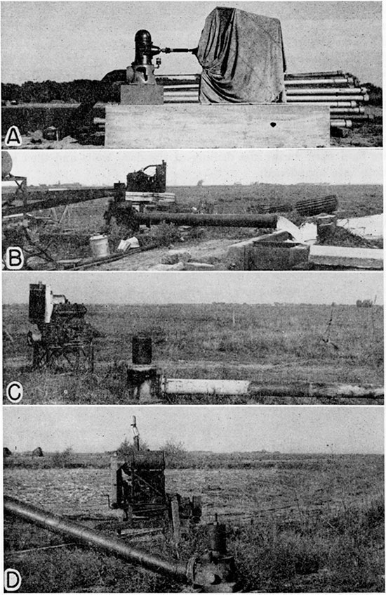
During the summers of 1944 and 1945 an inventory of the irrigation wells in Pawnee and Edwards counties was made, and estimates of the total pumpage and of the acreage irrigated in 1943 were obtained. The records of all the irrigation wells visited are given in Tables 15 and 16 and the locations of the wells are shown on Plate 2. Records of 127 irrigation wells (69 in Pawnee County and 58 in Edwards County) were obtained; only 76 were in use in 1943. The records indicate that about 3,400 acre-feet of water was pumped in 1943 to irrigate about 3,380 acres of land.
During the years of below-normal precipitation between 1930 and 1940, irrigation in this area was extensive and many new irrigation wells were constructed. After 1940, however, the precipitation generally was far above normal and the shortage of farm laborers was acute. As a result, only about 60 percent of the irrigation wells were in use in 1943 and additional wells were abandoned after 1943. The pumpage from those wells in use had declined sharply by 1943. Although the precipitation in this area was below normal in 1943, the soil moisture was above normal and the labor shortage remained acute; hence, the total pumpage was about 1 acre-foot of water for each acre of land irrigated. During this investigation an attempt was made to learn the number of acres of land under ditch so that an estimate of the prewar irrigated acreage could be made, but this proved unsuccessful. The irrigated acreage in Pawnee and Edwards counties in 1944 was 7,780 and 924 acres, respectively.
Yield
The yields of the irrigation wells in Pawnee and Edwards counties vary widely. A few of the smaller plants yield less than 250 gallons a minute, whereas some of the larger plants yield nearly 2,000 gallons a minute. The yields of the irrigation wells given in Tables 15 and 16 were reported by the owners and may be subject to considerable error. In Table 4 the irrigation wells of Pawnee and Edwards counties are classified according to their yield.
Table 4--Yield of irrigation wells in Pawnee and Edwards Counties
| Yield (gallons a minute) |
Number of Wells | ||
|---|---|---|---|
| Pawnee County | Edwards County | Total | |
| Less than 250 | 1 | 5 | 6 |
| 251-750 | 20 | 15 | 35 |
| 751-1250 | 32 | 17 | 49 |
| Greater than 1,250 | 9 | 8 | 17 |
| Unknown | 7 | 13 | 20 |
| Total | 69 | 58 | 127 |
The yield of many of the earlier plants in this area (particularly in Pawnee Valley) were increased by connecting a battery of shallow wells to one pump. These plants used centrifugal pumps; hence the yields were limited because the drawdown could not exceed the suction limit. In recent years the tendency has been to drill single deep gravel-wall wells and to equip them with turbine pumps. The newer wells generally draw water from all water-bearing materials above the Cretaceous bedrock.
Construction
Most of the larger irrigation wells in Pawnee and Edwards counties were constructed by professional well drillers; however, many of the wells, particularly in Edwards County, were drilled by farmers. The home-made plants generally are poorly constructed and have low efficiencies. This probably accounts in part for the high rate of abandonment of irrigation wells in Edwards County.
Several methods of well construction have been used in Pawnee and Edwards counties. The older irrigation wells in this area were constructed by digging a pit nearly to the water table and then drilling a well through the bottom of the pit. The sides of the pit generally were walled with wood or concrete and the drilled part was cased with perforated galvanized-iron casing. In wells having a small yield and a small drawdown, the pumps were placed at the ground surface, but where the anticipated yield and drawdown were large, the pumps were placed at the bottom of the pit. Where greater yields were desired, several wells of this type were dug and drilled and were connected to one pump. These wells generally were only 30 to 50 feet deep and did not utilize the entire thickness of coarse water-bearing material.
Most of the newer plants in the Pawnee-Edwards area consist of a single gravel-wall well that penetrates all water-bearing materials above the Cretaceous bedrock. These wells are equipped with deep-well turbine pumps (Pl. 5). The details of construction of this type of gravel-wall well are described on page 40.
Wells of greater capacity and efficiency than many now in use could be obtained in this area if better methods of well construction were used. Most of the home-made plants in Edwards County do not penetrate the entire thickness of water-bearing material. Many of the plants consisting of a battery of wells are poorly constructed and the individual wells are never spaced widely enough to prevent mutual interference. The wells of a plant practically never are aligned in a direction at right angles to the direction of movement of ground water, but instead are generally aligned along a fence or a road, causing an increase in the mutual interference of the wells.
Some wells in Pawnee and Edwards counties penetrate water-bearing formations that are so fine-grained that the wells should be gravel-packed; others have been gravel-packed with gravel that is less satisfactory than the water-bearing material it replaced. For detailed descriptions of gravel-packing, the reader is referred to Rohwer (1940), Bennison (1943), and Davison (1939).
Depth and Diameter
More than half the irrigation wells in the Pawnee-Edwards area are less than 50 feet deep, owing to the large number of shallow home-made wells in Edwards County and to the many old dug and drilled wells in the Pawnee Valley. The deeper wells are largely the newer wells that are equipped with turbine pumps. The irrigation wells in Pawnee and Edwards counties are classified in Table 5 according to depth.
Table 5--Depth of irrigation wells in Pawnee and Edwards Counties.
| Depth (feet) | Number of wells | ||
|---|---|---|---|
| Pawnee County | Edwards County | Total | |
| Less than 50 | 22 | 47 | 69 |
| 51-75 | 16 | 8 | 24 |
| 76-100 | 21 | 3 | 24 |
| 101-125 | 6 | 0 | 6 |
| Unknown | 4 | 0 | 4 |
| Total | 69 | 58 | 127 |
The diameters of the irrigation wells in this area range from 8 inches in a few of the small plants to several feet in a few dug wells. Most of the wells are cased with galvanized-iron casing ranging in diameter from 16 to 24 inches. The irrigation wells in this area are classified in Table 6 according to diameter. For wells that are dug and drilled, the diameter of the drilled part is given.
Table 6--Diameter of irrigation wells in Pawnee and Edwards Counties.
| Diameter (inches) | Number of wells | ||
|---|---|---|---|
| Pawnee County | Edwards County | Total | |
| Less than 16 | 3 | 6 | 9 |
| 16 | 6 | 9 | 15 |
| 18 | 2 | 4 | 6 |
| 19 | 29 | 1 | 30 |
| 20 | 4 | 2 | 6 |
| 22 | 0 | 13 | 13 |
| 24 | 17 | 5 | 22 |
| Greater than 24 | 4 | 8 | 12 |
| Unknown | 4 | 10 | 14 |
| Total | 69 | 58 | 127 |
Pumps
Most of the irrigation wells in Edwards County and the older irrigation wells in Pawnee County are equipped with centrifugal pumps, ranging in diameter of discharge pipe from 3 to 10 inches.
Most of the newer deep wells are equipped with turbine pumps, although some of the new shallow wells have centrifugal pumps. The diameters of the discharge pipes of the turbine pumps range from 6 to 10 inches.
Pump Power
Stationary gasoline engines and tractors are used to operate most of the irrigation wells in Pawnee and Edwards counties. Twenty-three plants are operated by electric motors and only one is operated by a natural-gas engine (Table 7). The power units generally are belted to the pump pulleys, but in some of the newer plants the motors are direct connected to the shafts.
Table 7--Type of power used for pumping irrigation wells in Pawnee and Edwards Counties.
| Type of power | Number of wells | ||
|---|---|---|---|
| Pawnee County | Edwards County | Total | |
| Electric motor | 19 | 4 | 23 |
| Gasoline engine | 31 | 20 | 51 |
| Natural-gas engine | 1 | 0 | 1 |
| Tractor | 15 | 29 | 44 |
| Unknown | 3 | 5 | 8 |
| Total | 69 | 58 | 127 |
Possibilities of Further Development of Irrigation Supplies From Wells
For the purpose of discussion, Pawnee and Edwards counties may be divided into three areas based upon the possibilities of further development of irrigation supplies from wells: (1) dune-sand area, (2) Arkansas Valley, and (3) Pawnee Valley.
Dune-sand area
The development of irrigation in the area of dune sand lying south of the Arkansas Valley is limited primarily by soil and surface slope. In the areas of youthful and mature dunes (Pl. 1) the soil is loose and sandy and is not suitable for irrigation and, in addition, the slope of the land is too great. In the areas of old-age dune sand (Pl. 1) the slopes are much less and the soil is thicker and more compact. Within these areas there is much land having soils and slopes such that irrigation could be developed. The depth to water level in all these areas is less than 50 feet. The thickness and coarseness of the water-bearing materials in this area are sufficiently great to permit the development of wells having moderately large yields. The porous soil and the undeveloped drainage in a large part of this area greatly facilitate recharge from precipitation.
Arkansas Valley
Irrigation in the Arkansas Valley in Pawnee and Edwards counties has been developed only slightly, owing in part to the character of the soil, which is too sandy or gravelly in some places. It is believed, however, that there is adequate ground water in the alluvium of the Arkansas Valley to permit extensive development of irrigation from wells. Inasmuch as the soil in many parts of the valley is very porous, the recharge from precipitation is rapid. In addition, water added to the ground-water reservoir by recharge in the sand-hills area adjacent to the valley moves into the alluvium in the Arkansas Valley.
If irrigation from wells were developed extensively in the Arkansas Valley and the water table were lowered over a wide area, Arkansas River would become a losing stream and would contribute large quantities of water to the ground-water reservoir in the valley. The amount of water that would be added to the ground-water reservoir by loss of stream flow is not known but it probably would be large. By way of comparison, the loss of water in Arkansas River between Syracuse and Garden City (a distance of about 50 miles) averaged nearly 32,000 acre-feet annually between 1922 and 1942 even though there was a net gain during two of those years (78,118 acre-feet in 1923-1924 and 6,830 acre-feet in 1928-1929). The greatest loss amounted to nearly 78,000 acre-feet in the water year 1941-1942, at the end of a long drought during which the water table had declined as much as 10 feet largely as a result of heavy withdrawals of water by wells for irrigation. The recharge from rainfall and from stream loss in the water year 1941-1942 was sufficient to restore the water table to its approximate pre-drought position, thus replenishing the ground-water reservoir (McLaughlin, 1943).
The channel of Arkansas River in Pawnee and Edwards counties is very similar to the channel between Syracuse and Garden City; that is, it is in most places wide and sandy and would permit relatively rapid downward percolation of water. Records of the stream flow at Garden City and Larned and of the loss of stream flow below those stations give some idea of the potential recharge from Arkansas River in this area (Table 8). The records show that generally Arkansas River gains in stream flow between Garden City and Larned. Much of this gain probably is derived from groundwater discharge and represents water lost from the ground-water reservoir that could be salvaged largely by a general lowering of the water table. The water thus salvaged would then be available to wells. Part of the gain in stream flow, however, is caused by additions of water from small tributary streams although no large tributaries are confluent with Arkansas River between the two gaging stations.
Table 8--Annual discharge of Arkansas River at Garden City and Larned, and loss or gain of stream flow between Garden City and Larned for the 18-year period from Oct. 1, 1922, to Sept. 30, 1940(1).
| Water year (Oct. 1 through Sept. 30) |
Annual discharge at Garden City (acre-feet) |
Annual discharge at Larned (acre-feet) |
Loss (-) or gain (+) between Garden City and Larned |
|
|---|---|---|---|---|
| Acre-feet | Percentage of discharge at Garden City |
|||
| 1922-1923 | 484,000 | 459,000 | -25,000 | 5.2 |
| 1923-1924 | 562,581 | 544,757(2) | -17,824 | 3 |
| 1924-1925 | 113,000 | 85,800 | -27,200 | 24.1 |
| 1925-1926 | 15,600 | 46,600 | 31,000 | 198.7 |
| 1926-1927 | 204,000 | 243,000 | 39,000 | 19.1 |
| 1927-1928 | 236,000 | 247,000 | 11,000 | 4.7 |
| 1928-1929 | 133,000 | 158,000 | 25,000 | 18.8 |
| 1929-1930 | 42,600 | 77,500 | 34,900 | 81.9 |
| 1930-1931 | 120,000 | 187,000 | 67,000 | 55.8 |
| 1931-1932 | 11,700 | 41,600 | 29,900 | 255.5 |
| 1932-1933 | 50,000 | 56,200 | 6,200 | 12.4 |
| 1933-1934 | 11,960 | 22,690 | 10,730 | 89.7 |
| 1934-1935 | 81,720 | 109,700 | 27,980 | 34.2 |
| 1935-1936 | 199,400 | 162,900 | 36,500 | 18.3 |
| 1936-1937 | 37,290 | 45,100 | 7,810 | 20.9 |
| 1937-1938 | 32,940 | 42,820 | 9,880 | 30 |
| 1938-1939 | 21,550 | 38,340 | 16,790 | 77.9 |
| 1939-1940 | 1,340 | 54,678 | 53,338 | 3,980.40 |
| 1. From records compiled by the Division
of Water Resources of the Kansas State Board of Agriculture in cooperation with the Water Resources Branch of the U. S. Geological Survey. |
||||
| 2. Includes estimated flow of 100,000 acre-feet for January and February. | ||||
The records also show that the channel of the river between Garden City and Larned is capable of absorbing relatively large quantities of water. There was a net loss in stream flow during the period from 1922 to 1925, the maximum loss being 27,200 acre-feet during the water year 1924-1925.
Pawnee Valley
Irrigation from wells has been developed more fully in the Pawnee Valley than in the Arkansas Valley in the Pawnee-Edwards area, owing primarily to the character of the soil, which is more suitable for irrigation. The upper part of the alluvium in the Pawnee Valley consists of clay and silt in most places and the soil derived from these materials generally is more suitable for irrigation than is soil derived from coarser sediments. The records of water levels in the Pawnee Valley show that the pumpage for irrigation between 1940 and 1947 did not materially affect the water level; in fact, the water table was higher in some areas in 1947 than it was in 1940. This period, however, was one of above-normal precipitation and below-normal pumpage.
The records of water-level fluctuations show that the groundwater reservoirs in this area are recharged from precipitation. The recharge from precipitation in the Pawnee Valley is believed to be less than that in the Arkansas Valley and areas south of that valley because the upper part of the alluvium is relatively fine-grained, which naturally reduces the rate of infiltration. The water table fluctuates in the relatively fine-grained material in the upper part of the alluvium; thus a given rise in water level reflects a smaller addition of water than an equal rise in coarser-grained material.
Pawnee River is also a possible source of recharge of the groundwater reservoir in the Pawnee Valley. If pumping for irrigation increases to the extent that the water table adjacent to the stream is lowered below the level of the stream channel, the river will then contribute water to the ground-water reservoir. The loss in stream flow probably would be small compared to that in parts of the Arkansas Valley because the channel is narrow and its bottom and sides generally consist of silt or clay, thus retarding the downward percolation of water.
Prev Page--Recharge, Discharge || Next Page--Quality
Kansas Geological Survey, Pawnee and Edwards Geology and Groundwater
Comments to webadmin@kgs.ku.edu
Web version June 2004. Original publication date March 1949.
URL=http://www.kgs.ku.edu/General/Geology/Pawnee/06_gw3.html