![]()
Prev Page--Abstract || Next Page--Geography
Introduction
Purpose and Scope of the Investigation
An investigation of the geology and ground-water resources of Pawnee and Edwards counties was begun in July 1944 by the United States Geological Survey and the State Geological Survey of Kansas, with the cooperation of the Division of Sanitation of the Kansas State Board of Health and the Division of Water Resources of the Kansas State Board of Agriculture.
Ground water is one of the principal natural resources of Kansas. Almost the entire population of Pawnee and Edwards counties obtains its water supply from wells. Ground water is also used to water livestock and to irrigate more than 3,000 acres of land. It is replenished by precipitation, by streams, or by both. If withdrawals of ground water are kept within safe limits, the supply will last indefinitely.
The extended drought between 1931 and 1939 caused repeated crop failures and a renewed interest in irrigation from wells in this area, and the number of irrigation wells in Pawnee County increased from 34 in 1930 to 69 in 1945. There is no record of the number of irrigation wells in Edwards County in 1930, but by 1945 there were 58 irrigation wells.
The investigation in Pawnee and Edwards counties was made to determine the quantity, quality, movement, and availability of ground water, and the feasibility of further development of irrigation from wells. It is hoped that the data given herein will facilitate the development of the ground-water resources of these counties.
Location and Extent of the Area
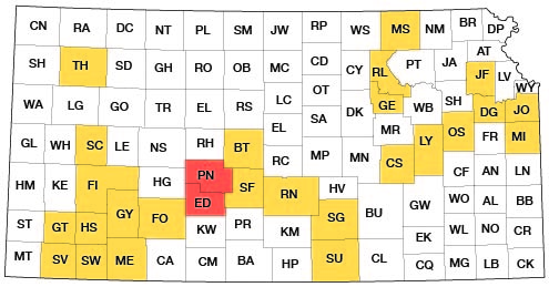
Pawnee and Edwards are adjacent counties in southwest central Kansas (Fig. 1). They are bordered on the north by Rush County, on the east by Barton, Stafford, and Pratt Counties, on the south by Kiowa County and on the west by Ness, Hodgeman, and Ford Counties. The area comprises 38 townships or 1,368 square miles.
Figure 1--Index map of Kansas showing area described in this report and areas covered by other online geologic reports, as of April 2004. For additional information, please visit the KGS Geologic Maps of Kansas Page.
Previous Investigations
Geologic and hydrologic studies in western Kansas were made in 1895 by Haworth (1897), who discussed the regional geology and the occurrence of ground water in the Dakota and younger formations. Johnson (1901, 1902) reported on the utilization of the southern High Plains with special reference to the source, availability, and use of ground water in western Kansas. Parker (1911) briefly described the geology and ground water resources of this area in his report on the chemical character of the water supplies of Kansas.
The geology of Pawnee and Edwards counties was mapped by M. K. Elias for use in the geologic map of Kansas (Moore and Landes, 1937) and Courtier (1934) mapped this area as a part of his study of south-central Kansas. No other studies of the geology or ground-water resources of this area were published prior to this investigation, but a report on the geology and ground-water resources of Ford County has been published (Waite, 1942).
Methods of Investigation
Field work was begun in Pawnee County in July 1944 and continued until October 1944. The field work in Edwards County was done during July and August 1945. During this season I was assisted by Milton Sears and Nels Florell. Data were obtained for 360 wells, most of which were measured with a steel tape to determine the depth of the well and the depth to the water level below some fixed measuring point (generally the top of the casing). Additional data were obtained from well owners concerning the yield and drawdown of wells and the character of the water-bearing materials. Samples of water were collected from 74 representative wells and were analyzed by Howard Stoltenberg, chemist in the Water and Sewage Laboratory of the Kansas State Board of Health.
One hundred thirty-one test holes were drilled at strategic points in the area by the portable hydraulic-rotary drilling machine of the State Geological Survey, operated by Oscar S. Fent and James B. Cooper. The drill cuttings were collected and studied in the field by Oscar S. Fent and examined later with a microscope by William J. Powell and me. The altitudes of the measuring points of the measured wells and of the test-hole locations were determined with a plane table and alidade by Charles K. Bayne and R. W. Ball.
The field data were recorded on maps prepared for the Kansas Highway Planning Board by the Kansas Highway Department. The data were then plotted on maps prepared by the Soil Conservation Service (Pls. 1 and 2). The roads were corrected by field observations.
The wells shown on Plate 2 were located within the sections by use of an odometer, and the locations are believed to be accurate within 0.1 mile. The wells in each county are numbered by townships from north to south and by ranges from east to west, and within a township the wells are numbered in the same order as the sections. The wells in Pawnee County are numbered from 1 to 185 and the wells in Edwards County are numbered from 186 to 360. For each well shown on Plate 2 the number above the line corresponds to the number of the well in the well tables and the number below the line is the depth to the ground-water table below land surface.
Acknowledgments
Residents of the area were very cooperative in supplying information about their wells and in permitting test drilling on their land. Particular thanks are due Hugh Richwine and C. B. Dennis of the Soil Conservation Service and Lytle Martin, Otis Shuck, and Roy Delp, drilling contractors. Leo Myers, superintendent of the Larned public utilities, supplied information on the municipal wells at Larned and on several irrigation wells.
The manuscript for this report has been critically reviewed by several members of the Federal Geological Survey and the State Geological Survey of Kansas; by George S. Knapp of the Division of Water Resources, Kansas State Board of Agriculture; and by Ben L. Williamson and Ogden S. Jones of the Division of Sanitation, Kansas State Board of Health. The maps and illustrations were prepared by Woodrow Wilson and Donald C. Forrey.
Prev Page--Abstract || Next Page--Geography
Kansas Geological Survey, Pawnee and Edwards Geology and Groundwater
Comments to webadmin@kgs.ku.edu
Web version June 2004. Original publication date March 1949.
URL=http://www.kgs.ku.edu/General/Geology/Pawnee/03_intro.html