![]()
Prev Page--Geology || Next Page--Recharge, Discharge
Ground Water
Principles of Occurrence
This discussion of the principles governing the occurrence of ground water takes account of conditions in Pawnee and Edwards counties. Preparation of the discussion has been based chiefly on the authoritative and detailed treatment of the occurrence of ground water by Meinzer (1923), to which the reader is referred for more extended consideration. A general discussion of the principles of ground-water occurrence, with special reference to Kansas, has been published by Moore (1940).
The rocks that make up the outer crust of the earth generally are not entirely solid, but have numerous openings, called voids or interstices, which may contain air, natural gas, oil, or water. The number, size, shape, and arrangement of the interstices in rocks depend upon the character of the rocks. The occurrence of water in any region, therefore, is determined by the geology.
The interstices or voids in rocks range in size from microscopic openings to the huge caverns found in some limestones. The open spaces generally are connected so that water may percolate from one to another, but in some rocks these open spaces are isolated and the water has little or no chance to percolate. Several common types of open spaces or interstices and the relation of texture to porosity are shown in Figure 4.
Figure 4--Diagram showing several types of rock intensities and the relation of rock texture to porosity. A, Well-sorted sedimentary deposit having high porosity; B, poorly sorted sedimentary deposit having low porosity; C, Well-sorted sedimentary deposit consisting of pebbles that are themselves porous, so that the deposit as a whole has a very high porosity; D, well-sorted sedimentary deposit whose porosity has been diminished by the deposition of mineral matter in the interstices; E, rock rendered porous by solution; F, rock rendered porous by fracturing. (From Meinzer, 1923a).
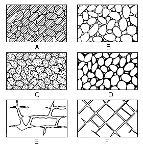
The porosity of a rock is the percentage of the total volume of the rock that is occupied by interstices. A rock is said to be saturated when all its interstices are filled with water or other liquid, and the porosity is then practically the percentage of the total volume of the rock that is occupied by water. The porosity of a rock determines only the amount of water a given rock can hold, not the amount it may yield to wells. Some rocks may be highly porous, but will not yield an appreciable amount of water to a well. The specific yield of a water-bearing formation is defined as the ratio of (1) the volume of water which, after being saturated, it will yield by gravity to (2) its own volume. It is a measure of the yield when the material is drained by a lowering of the water table. The permeability of a water-bearing material is defined as its capacity for transmitting water under hydraulic head, and is measured by the rate at which it will transmit water through a given cross section under a given difference of head per unit of distance. A rock containing very small interstices may be very porous, but it would be difficult to force water through it, whereas a coarser-grained rock although it may have less porosity, generally is much more permeable. Some water is held in rocks by the force of molecular attraction, which, in fine-grained rocks, is sufficiently great to hold the water against the force of gravity and thus to make the rock relatively impermeable.
Below a certain level in the earth's crust, the permeable rocks generally are saturated with water and are said to be in the zone of saturation (Fig. 5). The upper surface of the zone of saturation is called the ground-water table, or simply the water table. All the rocks above the water table are in the zone of aeration, which ordinarily consists of three parts: the belt of soil water; the intermediate or vadose zone; and the capillary fringe.
Figure 5--Diagram showing divisions of subsurface water (after Meinzer, 1923a).
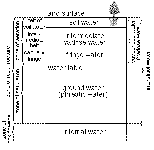
The belt of soil water lies just below the land surface and contains water held by molecular attraction. In this belt the amount of water must exceed that which will be held by gravity before any water can percolate downward to the water table. The thickness of the zone is dependent upon the character and thickness of the soil and upon the precipitation and vegetation. The intermediate belt lies between the belt of soil water and the capillary fringe. In this belt the interstices in the rocks contain some water held by molecular attraction but also may contain appreciable quantities of water while it is moving downward from the belt of soil moisture to the ground-water table. The intermediate belt may be absent in places, such as in some river valleys where the water table is near the surface, or it may be several hundred feet thick.
The capillary fringe lies directly above the water table and is formed by water held above the zone of saturation by capillary force. The water in the capillary fringe is not available to wells, which must be deepened to the zone of saturation before water will enter them. The capillary fringe may be absent or very thin in coarse-grained sediments, in which the capillary action is negligible, or it may be several feet thick in fine-grained sediments.
Artesian Conditions
The head of water has been defined as the height that a column of water will rise in a tightly cased well that has no discharge. Ground water that rises in wells above the level at which it is first encountered is said to be artesian or "piestic" water (Meinzer and Wenzel, 1942, p. 451).
Many of the deeper wells in Pawnee and Edwards counties have encountered artesian water, but only in a few of them has the head been sufficient to cause them to flow at the surface. A few oil or gas test wells in the Arkansas and Pawnee Valleys encountered water under artesian pressure in the Permian redbeds. One of these wells had a reported flow of 700 gallons a minute. Water from these wells was of such poor quality that it was unfit for use. Test hole 28 drilled by the State Geological Survey obtained a small flow of water from the Permian redbeds at a depth of about 415 feet. The water contained more than 1,500 parts per million of chloride.
Most of the deep domestic and stock wells in the upland areas of Pawnee and Edwards counties encounter artesian water in the Dakota formation. The water does not have sufficient head to cause it to flow at the surface, but it rises in the well enough to materially decrease the pumping lift. Any well that might be drilled to the Cheyenne sandstone probably would encounter water under artesian pressure, but it is doubtful if that pressure would be sufficient to cause the water to flow.
The Water Table and Movement of Ground Water
The upper surface of the zone of saturation in ordinary permeable soil or rock has been defined as the ground-water table, or simply the water table. Where the upper surface is formed by impermeable material the water table is absent and artesian conditions are said to exist. The water table is not a plane surface in all parts of the area but in some places has irregularities, comparable with and related to those of the land surface, although it is less rugged. It does not remain in a stationary position but fluctuates up and down. The irregularities are caused chiefly by local differences in gain and loss of water, and the fluctuations are due to variations from time to time in gain or loss.
Shape and Slope
The shape and slope of the water table in Pawnee and Edwards counties is shown on the map (Pl. 1) by contour lines drawn on the water table. Each point on the water table on a given contour line has the same altitude. The water-table contours show the configuration of the water surface just as topographic contour lines show the shape of the land surface. The direction of movement of the ground water is at right angles to the contour lines in the direction of the downward slope.
The water-table contours are not shown in the upland areas of Pawnee and Edwards counties. In and near the areas of outcrop of Cretaceous beds the land is underlain primarily by relatively impermeable beds; therefore, there is no water table in much of this area. Where the surface is covered by terrace deposits there generally is a little ground water at the base of these deposits, but the water surface merely reflects the topography of the underlying bedrock.
The map (Pl. 1) shows that the general movement of ground water in the Pawnee-Edwards area is eastward and northeastward. The rate and direction of movement vary considerably from one part of the area to another. The slope of the water table in the Pawnee Valley, for example, is only one-third as great as it is in parts of the Arkansas Valley, owing primarily to the difference in gradient of the two valleys. The direction of movement of the ground water in most of the area is northeastward but in southern Edwards County the direction of movement is approximately eastward.
The shape and slope of the water table, which determine the direction and rate of movement of ground water, are controlled by several factors. Irregularities of the shape and slope of the water table in Pawnee and Edwards counties may be caused by: (1) the configuration of the underlying Cretaceous floor; (2) discharge of ground water into streams; (3) recharge of the ground water by ephemeral streams; (4) unequal additions of water to the groundwater reservoir at different places; (5) local differences in the permeability of the deposits; and (6) local depressions on the water table caused by the pumping of water from wells.
The shape of the underlying bedrock floor controls to some extent the direction of movement of the ground water in this area. The regional slope of the bedrock floor is toward the east and southeast. This may be in part the cause of the direction of movement in this area. Local small irregularities in the bedrock surface, however, are not reflected in the shape of the water table.
The discharge of ground water into streams is the cause of the most prominent irregularities in the water table in this area. The upstream flexure of the contour lines along Pawnee River, Arkansas River, and Rattlesnake Creek has been caused by that process.
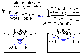
The recharge of ground water by ephemeral streams has not materially affected the water table in this area, although some water undoubtedly is added to the ground-water reservoir in this manner. An ephemeral or intermittent stream is one that flows only after rains. Their channels lie above the water table and are dry much of the time, but during periods of stream flow part of the water may seep into the stream bed and move downward to the water table. A stream of this type is said to be influent. The movement of ground water from influent streams and to effluent streams is shown by the diagrammatic sections in Figure 6.
Figure 6--Diagrammatic sections showing influent and effluent streams. (From Latta, 1944)
Unequal additions of water to the ground-water reservoir have not been great enough to affect materially the shape or slope of the water table in Pawnee and Edwards counties. In the sand-hills area south of Arkansas River there are many undrained basins in which water accumulates. Much of this water moves through the porous sandy soil and builds a mound on the underlying water table.
These local mounds are small and, hence would not be shown on a large-scale map such as Plate 1. The curvature of the contour lines along the Arkansas Valley is much greater on the south side of the river than it is on the north side of the river. This probably is the result of rapid recharge of the ground-water reservoir in the large undrained area of sand hills that borders Arkansas River on the south.
The lack of uniformity of gradient across the Pawnee-Edwards area probably is caused in part by local differences in permeability. The gradient along Arkansas River in the southwestern corner of Edwards County, for example, is about 15 feet to the mile, whereas a short distance downstream it is only about 5 feet to the mile. In the southwestern corner of Edwards County the unconsolidated materials through which the water moves probably are less permeable than they are farther downstream; hence the water table must have a steeper slope in order that a given cross-sectional area will transmit the same amount of water.
Local depressions in the water table have been caused by pumping for irrigation but the water table in these depressions generally rises to or nearly to its normal level within a short period after pumping ceases. These depressions, therefore, generally are not permanent features of the water table. Water-level measurements made while an irrigation well was pumping or soon after it stopped pumping were not used in the construction of the water-table contour map shown on Plate 1.
Relation to Topography
The depths to water level in Pawnee and Edwards counties are shown by a map (Pl. 2). The depth to water level in all wells that obtain water from superficial deposits generally is less than 25 feet and is in no place more than 50 feet. Those wells having water levels greater than 50 feet obtain water from the Dakota formation. The greatest measured depth to water level in this area was 199 feet in well 20, which obtains water from the Dakota formation. In general the shape of the water table in Pawnee and Edwards counties conforms to the regional topography, but is little affected by minor physiographic features.
Fluctuations in Water Level
The water table in a ground-water reservoir does not remain stationary, but fluctuates up and down much like the water surface of any surface reservoir. Whether the water table rises or declines depends upon the amount of recharge into the ground-water reservoir and the amount of discharge from the reservoir. If the inflow exceeds the draft, the water table will rise; conversely, if the draft exceeds the inflow into the ground-water reservoir, the water table will decline. The water table fluctuates more by the addition or depletion of a certain quantity of water than does the level of a surface reservoir, because ground water occupies only part of the volume of a ground-water reservoir. If the materials comprising a water-bearing formation have an average specific yield of 25 percent, for example, the addition of 1 foot of water to the water-bearing materials will raise the water table in those materials about 4 feet. Changes of water levels record the fluctuations of the water table and hence are a measure of the recharge and discharge of a ground-water reservoir. A rise in water level indicates an excess of recharge over discharge, whereas, a decline in water level indicates that the discharge exceeds the available recharge.
The principal factors that control the rise of the water table in Pawnee and Edwards counties are the amount of water from precipitation that passes through the soil and moves downward to the water table, the amount of water added to the ground-water reservoir by seepage from streams, and the amount of water that enters the area by subsurface inflow. The principal factors that control the decline of the water table in this area are the amount of water discharged by effluent seepage into streams, the amount of water lost through transpiration and evaporation where the water table is shallow, the discharge of water through springs and wells, and the amount of water leaving the area through subsurface flow into adjacent areas.
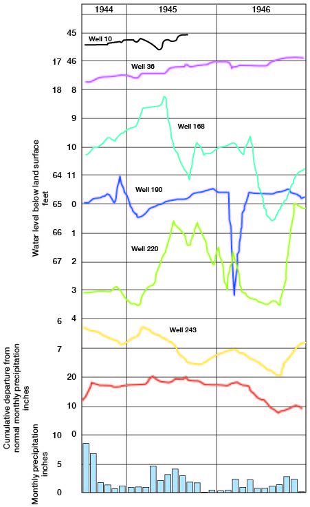
Fluctuations of the water table are reflected directly in changes in the water levels in wells. In order to record these changes on a monthly basis, several representative wells in Pawnee and Edwards counties were selected as observation wells. Periodic measurements of water levels in these wells have been made for several years and their fluctuations are shown by the hydrographs in Figures 7 and 8.
Fig. 7--Hydrographs showing fluctuations of the water levels in three wells in Pawnee Valley in Pawnee County, cumulative departure from normal monthly precipitation at Larned, and monthly precipitation at Larned. A larger version of this figure is available.
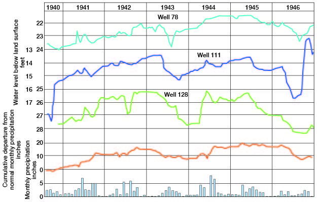
Fig. 8--Hydrographs showing fluctuations of the water levels in six wells in Pawnee and Edwards counties, cumulative departure from normal monthly precipitation at Larned, and monthly precipitation at Larned.
Prev Page--Geology || Next Page--Recharge, Discharge
Kansas Geological Survey, Pawnee and Edwards Geology and Groundwater
Comments to webadmin@kgs.ku.edu
Web version June 2004. Original publication date March 1949.
URL=http://www.kgs.ku.edu/General/Geology/Pawnee/06_gw.html