![]()
Prev Page—Geography || Next Page—Buried Rocks
Stratigraphy: Rocks Exposed
The surface rocks of Ness and Hodgeman counties are of Quaternary, Tertiary and Cretaceous age. The soils and alluvium are the most recent, the Ogallala (Tertiary) is the next oldest, and the Cretaceous strata, including the Dakota, Benton and Niobrara formations, are the oldest rocks exposed in the area. These rocks are underlain by still older rocks that have been penetrated by deep wells and will be taken up in a later section of this report. The table on the opposite page outlines the rocks exposed in stratigraphic order with the oldest at the bottom.
Table 1—Table of rock formations in Ness and Hodgeman counties, Kansas.
| System and Series | Formation and member | Lithologic character | Thickness in feet |
||
|---|---|---|---|---|---|
| Quaternary | Recent | Soil. Stream alluvium. Sand and gravel. Talus. | 0-40 | ||
| Pleistocene (?) | Upper terrace deposits of sand and gravel. Volcanic ash. | 0-15 | |||
| Tertiary | Pliocene | Ogallala | Both consolidated and unconsolidated silt, grit, sand and gravel on the High Plains. | 0-100 | |
| Unconformity | |||||
| Cretaceous | Upper Cretaceous |
Niobrara Formation | Smoky Hill chalk member | Alternating beds of soft chalk and chalky shale. Some thin bentonite beds. | 0-225 |
| Fort Hays limestone member | Massive chalk beds up to six feet thick alternating with thin, soft chalky shales. | 80 | |||
| Unconformity | |||||
| Carlile shale | Blue Hill shale member | Bluish-gray, fissile clay shale with sandy zone at top and septarian concretions in upper part. | 260 (a) |
||
| Fairport shale member | Chalky shale with thin chalky limestone beds and small, discoidal concretions at base. | ||||
| Greenhorn limestone | Pfeifer shale member | Chalky shale with thin chalky limestones, discoidal concretions and thin bentonite beds. "Post rock" limestone at top. | 19-21 | ||
| Jetmore chalk member | Alternating beds of chalky shale and chalky limestone. "Shell" limestone at top. | 23 | |||
| Hartland shale member | Chalky shale with few thin beds of chalky and granular limestone and thin bed, of bentonite. | 80 | |||
| Lincoln limestone member | Chalky shale with thin beds of crystalline limestone and thin bentonite beds. | ||||
| Graneros shale | Bluish-gray clay shale, sandy shale and sand lenses. | 21-36 | |||
| Dakota sandstone | White to brown lenticular sandstone with gray and variegated sandy shale. Only top of formation exposed. | 50 | |||
| a. Phillips Petroleum Company core hole. | |||||
Quaternary System
Recent Deposits
The soil covering of most of the area and the alluvium deposited by the streams are of Recent age. These deposits are, for the most part, silty clays and sandy barns with some loess. The thickness of the soil varies from a few inches to several feet. The stream alluvium is 20 to 50 feet thick in some places. Besides the barns and clays there are some deposits of talus and sand and gravel in the Recent deposits.
A mantle of soil obscures the bedrock over most of the area of Ness and Hodgeman counties. The southward-facing slopes are gently graded and covered by a rather thick, fertile soil, except where some resistant stratum is near the surface. Areas where the Jetmore member of the Greenhorn limestone and the Fort Hays limestone crop out have only a thin mantle of soil. The southward-facing slopes are generally tillable. On the other hand, the northward-facing slopes usually have scant soil covering and the steeper bedrock slopes contain accumulations of talus. Examples of talus slopes are the slopes immediately south of Jetmore and the slopes on the south side of Walnut Creek, near Beeler.
The plateau-like uplands of the high plains are covered by a sandy loam that is usually several feet thick and is considered the best wheat land. The soil does not contain as much moisture as the bottom land, but it seems to have the property of giving up its moisture for plant growth better, so that the crops raised here are nearly as good as on the bottom lands. This property of the soil and the undissected character of the uplands make them the best areas for wheat raising.
Soils derived from the upper 200 feet of the Carlile shale are not very fertile. This part of the Carlile is a noncalcareous clay-shale which weathers into a sticky gumbo soil that is difficult to till and does not produce good crops.
The flood plains of the larger streams have a good soil and are used for raising corn, wheat and some hay and feed. Those of Pawnee River, in the eastern two-thirds of Hodgeman County, and Walnut Creek, east of Ness City, are the widest and contain large and prosperous farms.
Sand and Gravel
The stream beds contain deposits of sand and gravel that have been derived from the Ogallala formation, the Pleistocene (?) sands and gravels, and the Cretaceous chalky limestones. The pebbles of chalk in these deposits are an objectionable constituent for structural work because they weaken a concrete aggregate.
Pleistocene (?) Deposits
Beds of unconsolidated sand and gravel that occur along the slopes south of Pawnee River in the western half of Hodgeman County may belong to the Pleistocene. They lie in most places from 100 to 150 feet above the present level of Pawnee River. The position of this sand and gravel indicates that it is a remnant of a former terrace of Pawnee River. Similar deposits along Smoky Hill River in Ellis and Russell counties have been referred to the Pleistocene by Bass (Rubey and Bass, 1925, p. 19). The beds are made up chiefly of granitic sands and pebbles but contain, also, some chert and limestone pebbles. This material was derived from areas of Ogallala and other rocks to the west. The Pleistocene (?) gravel and sand are exposed on the ridges between the small ravines and in the cut-banks of the ravines. On the ridges the presence of sand and gravel may be recognized by pebble-strewn areas which are almost barren of vegetation. The "soap weed" (Yucca) grows on the deposits and on the wash derived from them.
Volcanic Ash
Two deposits of volcanic ash were noted in the area: one at Ness City (Landes, 1929, p. 36) and the other southwest of Beeler, a quarter of a mile east of the southwest corner of sec. 6, T. 19 S., R. 26 W. This latter deposit is exposed for 400 feet along the edge of a small, northward-facing hill. The ash is six feet thick where exposed by animal burrows. At the point of exposure there is about three feet of overburden. The area of the deposit probably does not exceed an acre. The ash lies on lower Smoky Hill chalk and is about 50 feet below the Ogallala.
Tertiary System
Ogallala Formation
The Ogallala formation is made up of sand, grit, gravel and silty clays that are cemented by calcium carbonate in some places. The mortar-like appearance of the gritty beds that have been cemented has caused them to be called "mortar beds." The "mortar beds" are the most conspicuous part of the formation, since they are resistant to erosion and form benches and, in some cases, vertical bluffs. The materials composing the Ogallala deposits were derived from the erosion of pre-Ogallala rocks to the west, chiefly from the Rocky Mountain uplift. The material was carried eastward and deposited by streams in the form of a gigantic piedmont plain. The gritty, unsorted character of the deposits suggest that they were deposited under arid conditions by sporadic floods of the streams. The material is chiefly granitic sands and pebbles with a few pebbles of chert, limestone and basic igneous rocks.
The Ogallala formation caps the plateau-like uplands that make up about a third of the area of Ness and Hodgeman counties. These uplands are the eastern fringe of the high plains which rise gently westward to the Rocky Mountains. Since the Ogallala formation is more resistant than most of the underlying Cretaceous strata there is a distinct topographic break in most places at the contact. On the north-facing slopes the Ogallala beds form a steep slope, and along the northward-flowing streams they have been eroded into steep-walled valleys. Many of the northward-flowing tributaries of Buckner and Sawlog creeks are locally known as "canyons." On the south-facing slopes the topographic break is usually not pronounced and in places may not be evident, so that there is a gentle, unbroken slope from the top of the Ogallala down across lower strata to the bottom of the valleys. Thus, the contact between the Ogallala formation and the underlying Smoky Hill chalk on the north side of Walnut Creek south of Ransom and Utica cannot be distinguished by the topography. Also, where the Ogallala is in contact with the Fort Hays limestone or the Jetmore chalk member of the Greenhorn limestone there is little or no topographic distinction, because each is about equally resistant to erosion.
The Ogallala formation is 100 feet thick in the western part of the area. Farther west it is over 200 feet thick. This thinning to the east is probably due to a lesser amount of original deposition here, as the area is still in the first cycle of erosion since the close of the Tertiary period. There are, in some places, as many as three "mortar beds," but these cannot be traced very far and are irregular and probably discontinuous. The cemented beds are the most resistant to erosion. Since these "mortar beds" are due to cementation at successive stands of the ground-water table, it is not expected that they would be continuous or uniform, for a water table does not have a plane surface, and the porosity of the beds varies greatly. There is usually a "mortar bed" at the base of the formation where the base is of porous material. In the northeast corner of Ness County a small area was noted where the cement was of silica. This forms a hard quartzitic conglomerate. In general, however, the cement is calcium carbonate. The silty phases are poorly consolidated.
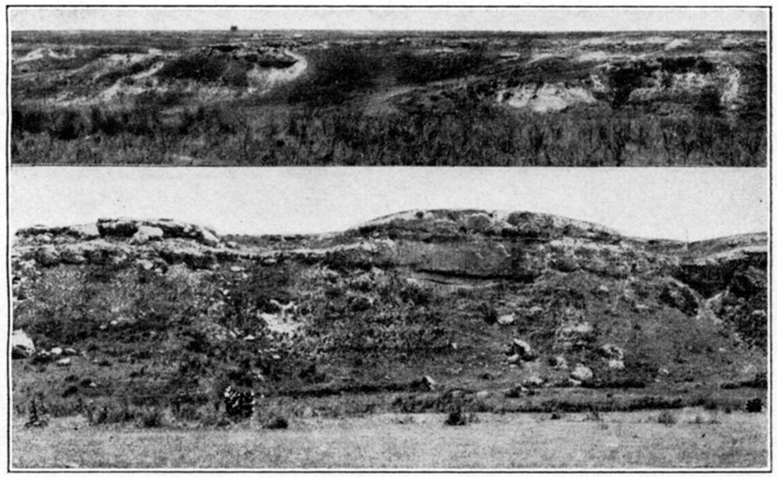
Plate III—Upper: "Mortar beds" of the Ogallala formation in sec. 23, T. 23 S., R. 25 W., Hodgeman County. Lower: "Mortar beds" capping the lower beds of the Fairport chalky shale in sec. 14, T. 23 S., R. 25 W., Hodgeman County.
The pre-Ogallala erosion surface in this area did not have much relief, for the contact of the Ogallala with the underlying beds is generally uniform. In places there was a relief of 20 to 40 feet, as indicated by the conclusion that present major drainage lines seem to have been resurrected, the Ogallala beds showing a dip down north-south ridges toward the present major drainage lines.
Since the Ogallala formation has a rather uniform eastward dip of about 10 feet to the mile and the Cretaceous strata a dip of about 10 feet per mile slightly east of north, the Ogallala overlaps successively older Cretaceous strata to the south and east. At the northwest corner of Ness County, where the Ogallala overlies the thickest Cretaceous section in the area, there is about 330 feet of the Niobrara formation. The Ogallala beds overlie 30 feet of the Niobrara in the northeast corner of Ness County. In the extreme northwest corner of Hodgeman County the Ogallala formation overlies 50 feet of Niobrara and the overlap increases from this point south so that the Ogallala overlaps both Carlile shale and the upper 25 feet of the Greenhorn limestone and lies upon the upper part of the Jetmore member at the southwest corner of the county. The Ogallala is probably in contact with the Dakota sandstone at the southeast corner of Hodgeman County.
Cretaceous System
Niobrara Formation
The Niobrara formation consists of beds of chalk and chalky shale, the latter predominating. The beds weather to a white, tan, buff, or yellowish-pink color, but unweathered exposures are in most cases bluish-gray. The formation is divided into two members, the Smoky Hill chalk above and the Fort Hays limestone below. The Niobrara formation has a thickness of approximately 800 feet in Logan County, Kansas, where it is overlain conformably by the Pierre shale, but it has been truncated to the east by pre-Ogallala erosion. Only the lower 368 feet of the chalk beds remain in Ness County and 50 feet in Hodgeman County.
Smoky Hill Chalk Member
The Smoky Hill chalk consists of soft beds of alternating chalky shale and chalk. On unweathered exposures the beds have a bluish-gray color, and all have the same general appearance and nearly the same hardness. On weathered exposures, however, the slight differences in the composition of different beds is brought out through differential erosion. Even the thinnest beds are differentiated by erosion. This delicate etching of the soft, chalky beds would probably not occur in a humid climate. Induration, or "casehardening," of chalk beds that have been exposed for a long time has taken place making them harder than their unweathered equivalents.
Numerous thin bentonite beds occur in the member. In the lower part there are few of these beds that exceed one-half inch in thickness, but in spite of their thinness they are the key to stratigraphic work within the Smoky Hill member. The bentonites are very persistent laterally, and the intervals between them are constant for short distances and change uniformly over great distances. The bentonite beds weather to a rusty-brown color.
Pyrite concretions are scattered throughout the member. They weather to limonite, and exposures of the chalk beds are strewn with brownish-yellow concretions which are discoidal and reach one foot in diameter. Besides the concretions, the beds contain large pelecypods (Inoceramus grandis) which, in the lower part, reach two feet in diameter and weather out to such an extent that some of the exposures are almost covered with pelecypod fragments and concretions.
Since the Smoky Hill chalk is soft, it commonly forms a gentle, soil-covered slope between the overlying Ogallala formation and the underlying Fort Hays limestone. Where exposures do occur the chalk has a bad-land topography that is characteristic of the member. These areas are small, and they are scattered along the southward trending valleys. Along the northward-trending valleys, however, they may cover several square miles. The thickness of the strata exposed in any of the smaller areas rarely exceeds 40 feet.
Only the lower part of the Smoky Hill chalk is present in this area. The greatest thickness is in the northwest corner of Ness County, where it is about 225 feet. Pre-Ogallala erosion truncated the member to the south and east, so it has been completely removed at the northeast and southwest corners of the county.
The following detailed section is a composite of many carefully measured exposures. These sections were measured a few miles north of Ness County and along Smoky Hill River in Trego and Gove counties, because the best exposures occur there. The beds were traced up the small tributaries of Smoky Hill River into Ness County to establish the correlation there. The section of the Smoky Hill chalk member is divided into zones, designated by letters starting at the bottom and lettered consecutively upward. These zones are not the same as those used by Bass (1926, 20) and Russell (1929, p. 595-604). Their "groups" do not form a continuous series but designate beds that are separated by undetailed intervals. A zone, as here used, consists of 20 to 35 feet of chalky shale capped by a resistant chalk bed. In one ease a thick shale (zone C) is set apart, because there is no convenient break in the chalk above. All of the zones contain thin beds of bentonite, which are very important because the intervals between them can be definitely recognized in correlation between exposures. Since there is rarely more than 40 feet of strata represented in any one area, and most of the exposures are capped by a resistant bed, these zones form a convenient lithologic unit.
| Partial Section of Smoky Hill Chalk Member of Niobrara Formation, Trego and Gove counties, Kansas. | ||
| Zone F--NE. 1/4 Sec. 20, T. 15 S., R. 26 W. | Ft. | In. |
|---|---|---|
| 47. Massive chalk | 1 | 0 |
| 46. Chalk and chalky shale with a thin bentonite at the top and one five inches below the top | 9 | 1 |
| 45. Alternating beds of chalk and pinkish chalky shale | 13 | 1 |
| 44. Bentonite | 0 | 1/4 |
| 43. Chalky shale and chalk | 5 | 7 |
| 42. Soft chalky shale with thin bentonite at top | 0 | 11 |
| 41. Chalky shale and chalk with thin bentonite at top | 5 | 3 |
| Zone E--Sec. 25, T. 15S., R. 26 W. | Ft. | In. |
| 40. Massive chalk bed with a thin bentonite parting at the top | 0 | 11 |
| 39. Chalky shale, tan | 1 | 5 |
| 38. Chalky shale with a thin bentonite parting at the top | 0 | 10 |
| 37. Chalky shale with a thin bentonite parting at the top | 1 | 1 |
| 36. Thin chalk beds and pinkish chalky shale with a thin bentonitic parting at the top | 8 | 5 |
| 35. Bentonite | 0 | 1/4 |
| 34. Soft chalk and pinkish chalky shale | 9 | 10 |
| Zone D--Sec. 13, T. 15 S., 11. 26 W. | Ft. | In. |
| 33. Resistant chalk bed. Forms good bench | 8 | 8 |
| 32. Soft chalky shale. Pinkish-brown color | 7 | 6 |
| 31. Chalk, forming a shoulder | 1 | 8 |
| 30. Chalk and chalky shale with a thin bentonite at top. A thin bentonite parting occurs three feet and nine inches below the top | 6 | 5 |
| 29. Massive buff chalk | 2 | 6 |
| 28. Chalky shale with thin beds of chalk. A thin bentonite parting is one foot and two inches above the base | 12 | 2 |
| 27. Massive chalk beds separated by thin, soft, chalky shales with a thin bentonite parting at the top | 12 | 0 |
| Zone C--NE. 14 Sec. 13, T. 14 S., R. 25 W. | Ft. | In. |
| 26. Chalky shale and soft chalk with a thin bentonite at base | 2 | 3 |
| 25. Chalk | 0 | 7 |
| 24. Chalky shale alternating with soft chalk beds | 11 | 4 |
| 23. Soft chalk | 5 | 0 |
| 22. Soft, tan chalky shale | 11 | 0 |
| Zone B--Sec. 29, T. 14 S., R. 25 W. | Ft. | In. |
| 21. Massive chalk with thin shale parting at base | 3 | 5 |
| 20. Massive chalk with parting eight inches below top | 2 | 2 |
| 19. Soft chalky shale with a dark-brown bentonitic clay 17 inches below top. Contains much pyrite | 2 | 11 |
| 18. Massive chalk | 0 | 11 |
| 17. Tan chalky shale | 0 | 7 |
| 16. Bentonite | 0 | 1 |
| 15. Chalk | 0 | 6 |
| 14. Chalk | 0 | 8 |
| 13. Chalky shale | 0 | 5 |
| 12. Chalk | 0 | 10 |
| 11. Chalky shale with thin bentonitic seams | 2 | 7 |
| 10. Chalky shale, lower part tissue; upper part chalky. Contains small pyrite concretions | 12 | 2 |
| 9. Bentonite | 0 | 1 |
| 8. Chalky shale | 2 | 3 |
| 7. Bentonite | 0 | 2 |
| 6. Soft chalky shale | 7 | 4 |
| Zone A | Ft. | In. |
| 5. Prominent chalk, hard at top and bottom | 3 | 2 |
| 4. Chalky shale and thin chalk beds | 15 | 0 |
| 3. Bentonite | 0 | 1/4 |
| 2. Chalky shale | 0 | 6 |
| 1. Bentonite | 0 | 1/2 |
| Top of Fort Hays limestone | ||
The above sections, zones A to F, have a thickness of 188 feet. Approximately 40 feet of the next highest zone (G) also occurs in Ness County, but it is not included here because it is not well exposed in the area. It is composed of very soft shale and exposures are rare.
Correlation and measurement in the Smoky Hill chalk is almost entirely dependent on the bentonite beds. This has been noted by Bass (1926), Pinkley and Roth (1928, p. 1015), and Russell (1929, p. 595-604). Some of the beds are only a paper-thin parting in which the bentonitic material has been replaced by pyrite which has subsequently been altered to limonite. The thickness of some of the bentonites may vary from place to place, but there is almost always some trace of them. The interval between horizons increases to the southwest. Comparison of sections measured at different localities indicates that for the lower beds in this area the rate of southwestward thickening is from two and one-half to three per cent per mile.
The Smoky Hill chalk member crops out in the north and west part of Ness County. It is absent in Hodgeman County, having been removed by pre-Ogallala erosion. The best exposures are at the north side of Ness County, along the small tributaries of Smoky Hill River. A few small exposures occur along the north and south forks of Walnut Creek at the west side of the county and along the north tributaries of the north fork of Walnut Creek as far east as Brownell. Parts of zones A and B occur north and south of Beeler. Only the lower few feet is exposed northeast of Beeler.
Marine invertebrate and both marine and nonmarine vertebrate fossils occur in the Smoky Hill chalk. The area of Niobrara outcrop in Kansas has long been famous for collecting and studying Cretaceous vertebrates, and most of the larger museums of the world have collections from here. Birds, dinosaurs, crocodiles, mosasaurs, turtles, and fish have been found in the member. Many species and genera of these vertebrates were first described from these beds.
Among invertebrates, Inoceramus (Haploscapha) grandis is the most abundant. Fragments of this pelecypod almost cover some of the exposures of the chalk beds. They are always thickly coated with Ostrea congesta, a small oyster which rarely occurs unattached. Inoceramus (Haploscapha) grandis attains a diameter of two feet or less in the beds exposed in Ness County, but. in the beds above some reach a diameter of three to five feet. The rudistid Radiolites maximus occurs sparingly at the base of the member (Logan, 1898, p. 480). Besides the larger invertebrates, multitudes of foraminifera, chiefly Globigerina and Gümbelina, occur in the chalky beds. These minute tests probably make up over half of the calcareous material of the chalk.
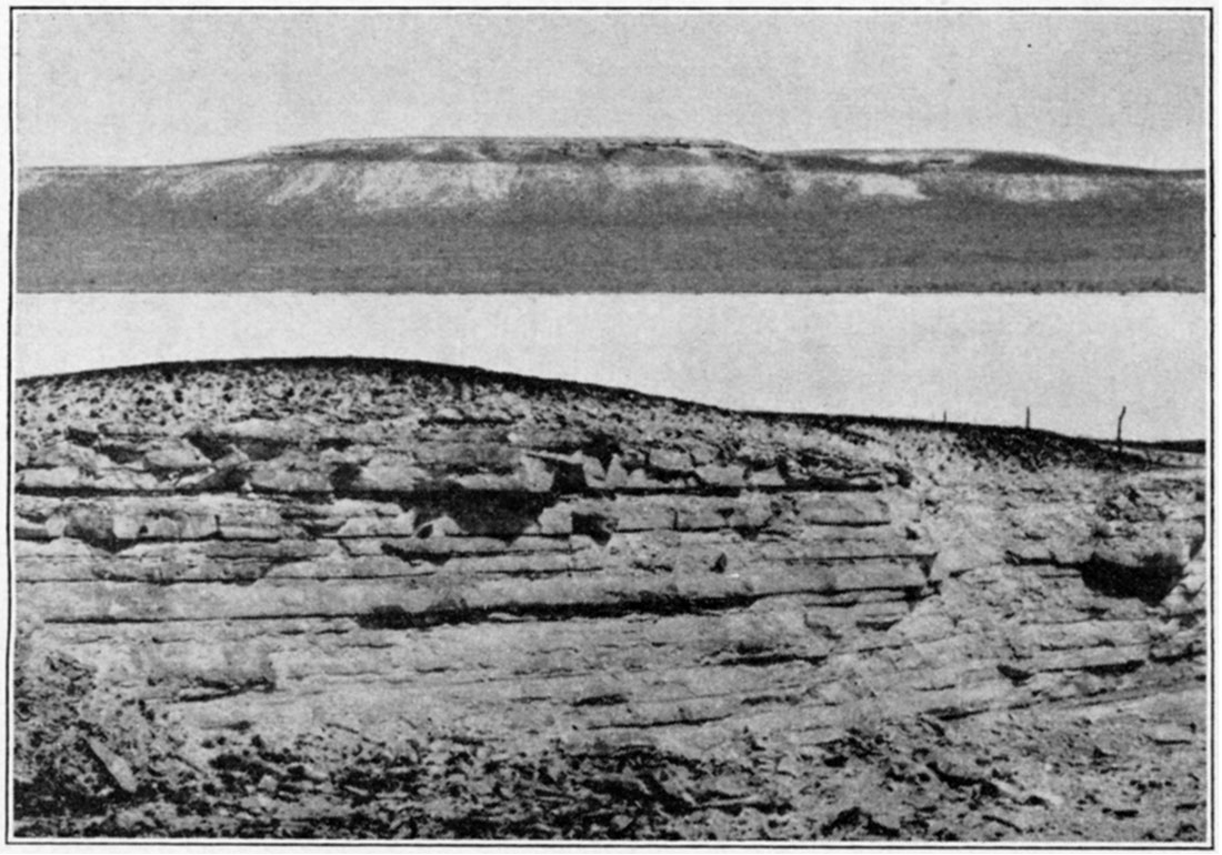
Plate IV—Upper: "Mortar beds" resting on the Jetmore chalk member of the Greenhorn limestone three miles southeast of Jetmore. Lower: Upper beds of the Fort Hays limestone in sec. 3, T. 17 S., R. 26 W., Ness County.
Fort Hays Limestone Member
The Fort Hays limestone lies conformably below the Smoky Hill chalk member. It is composed of thick, massive beds of chalk separated by thin beds of chalky shale. Some of the chalk beds are six feet thick, but the average is less than three feet. The shale partings rarely exceed four inches in thickness. The color of weathered exposures is tan, buff or cream, but in the unweathered state the beds are a light- or dark-gray color.
Since the Fort Hays limestone overlies the soft Carlile shale formation and is overlain by soft, chalky shale beds, it forms a well-defined escarpment in most places. The escarpment is especially prominent where the Ogallala formation rests on the Fort Hays member. Vertical bluffs are developed, especially on north-facing slopes, but on the south-facing slopes shoulders only appear. Gently sloping exposures are in all eases covered with chalk pebbles, and the base of steep bluffs is obscured by talus containing large blocks of chalk. Slumping is common on the steep slopes where, in some places, huge blocks have slipped down the Carlile slope 20 feet or more. Some of these slumped blocks have been mistaken for down-faulted blocks.
The contact between the Fort Hays limestone and the Smoky Hill chalk is transitional from predominating chalk beds to predominating chalky shale. The dividing point here used is the thin bentonite bed at the base of zone A of the Smoky Hill chalk. Although this is a few feet above any massive chalk beds, it is the only convenient and recognizable horizon at which to make a division. The use of this bentonite as the base of the Smoky Hill chalk makes the Fort Hays limestone 80 feet thick in Ness County. No detailed section of the Fort Hays member is given here, because none could be measured in the area, and as the individual beds are not persistent a section measured elsewhere could not be accurately correlated here.
The Fort Hays limestone crops out in a band extending diagonally across Ness County from the northeast to the southwest corner, making deep reentrants to the west in the valleys of Walnut Creek and Hackberry Creek. Except locally the band of outcrop does not exceed a mile in width, and in many places it is very narrow. The only Fort Hays limestone in Hodgeman County occurs in an area of less than half a square mile in the extreme northwest corner of the county. The only fossils visible, without using a microscope, in the Fort Hays limestone are Inoceramus deformis and Ostrea congesta. The member also contains abundant foraminifera.
Carlile Formation
The Carlile formation lies unconformably below the Fort Hays limestone. It is composed of two members, the upper two-thirds constituting the Blue Hill shale member, and the lower third the Fairport chalky shale member.
Blue Hill Shale Member
This member is a bluish-black, noncalcareous clay shale. It contains zones of large septarian concretions in the upper part and a sandy zone at the top. The sandy zone has been called the Codell sandstone bed by Bass (1928, p. 28).
The Blue Hill and the upper part of the Fairport form a slope between the Fort Hays limestone and the underlying lower Fairport and upper Greenhorn limestones. The upper part of the Blue Hill member forms a steep slope on the northward-facing hills, where it is overlain by the Fort Hays limestone. These slopes are devoid of vegetation in many cases and are strewn with large septarian concretions. The combination of a steep slope in the upper part of the Blue Hill shale and water seepage from the Codell sandstone bed has caused small landslides at numerous places. The landslides form hummocky areas in which small trees grow. The top of the Blue Hill member is commonly marked by a row of bushes that grow here because of the water in the Codell sandstone bed. The lower part of the member forms gentle slopes, and where exposures occur they are partially covered with selenite (gypsum) crystals.
The Blue Hill shale member is 175 feet thick in the southwest corner of Ellis County (Bass, 1928, p. 26). No measurement of the thickness could be made in Ness or Hodgeman counties as there are no complete exposures in this area. The following section shows the character of the upper part of the member.
| Section of Upper Part of Blue Hill Shale Member, measured in sec. 19, T. 17 S., R. 22 W., Ness County. | Ft. | In. |
|---|---|---|
| Fort Hays limestone member | ||
| 5. Gritty, bluish-gray shale with thin sand beds. The top six inches is a gray, limy sand that weathers to brownish-yellow | 21 | 0 |
| 4. Hard, gray concretionary sandstone bed | 0 | 4 |
| 3. Bluish-gray shale. Contains a few two-inch sandstone beds | 18 | 0 |
| 2. Bluish-gray shale with a zone of large, reddish-brown septarian concretions at the top. The concretions reach five feet in diameter | 21 | 0 |
| 1. Fissile, bluish-gray shale with a zone of large gray septarian concretions at the top | 10 | 0 |
| Lower beds concealed | ||
From other exposures it was found that the top of the upper concretionary zone varies from 39 to 41 feet below the top of the member. Sandy beds or sandy shale occur from this horizon up, but the sand is usually confined to the upper 15 to 20 feet, and the individual sand beds are thin. No cross-bedding was observed. The thin, sandy bed at the top of the member weathers to brownish-yellow. Johnson (1930, p. 789) has pointed out that the irregular character and thickness of the Codell sandstone and the phosphatic and conglomeratic character of this zone in eastern Colorado, together with the faunal break between the Carlile and Niobrara formations, indicate an unconformity. However, the strata above and below the contact are structurally conformable.
Microscopic examination of the Codell sandstone shows it to be composed of uniformly fine (average 0.4 mm diameter), angular quartz grains with a few fragments of altered feldspar and some small fish teeth and bones. Most of the sand grains are slightly frosted and pitted, and since the sand is fine this is probably due to eolian transportation. "Heavy mineral" analyses were made of a number of samples taken from the outcrop between Mitchell and Ness counties. The average of these gave the following: Zircon 68 per cent, tourmaline 12 per cent, garnet (grossularite) 12 per cent, rutile 5 per cent, staurohite 1 per cent, and traces of anatase, chlorite, muscovite, corundum and topaz. All of the zircon and the majority of the other minerals are in euhedral crystals or angular fragments. The zircon percentage rises from 58 per cent in Mitchell County to 87 per cent in Ness County. Since zircon is the most resistant mineral, this indicates that Ness County is farther from the source of the sand than Mitchell County. A mineral suite of this type denotes derivation from an area of predominant granitic rocks in which there are small exposures of basic igneous rocks and schist. Staurolite and rutile are not common in granites, but the rest of the minerals are. Staurolite characteristically occurs in schist.
The Blue Hill shale member crops out in a band two to five miles wide east of the Fort Hays limestone. This band is continuous from the northeast to the southwest corner of Ness County and crosses the northwest corner of Hodgeman County, covering an area west of Hackberry Creek and north of Pawnee River. The exact area over which the Blue Hill shale member crops out could not be determined, due to the gentle slopes and soil cover. For this reason the members of the Carlile formation are not differentiated on the geologic maps (Plates I and II).
Fossils are found in the septarian concretions of the Blue Hill shale member, but none were found in this area. Prionotropis woolgari, inoceramus fragilis, and species of scaphites are commonly found.
Fairport Chalky Shale Member
The contact between the Blue Hill shale and the Fairport chalky shale is not exposed in Ness or Hodgeman counties, but where observed in other areas it is marked by an abrupt change from underlying chalky shale to overlying noncalcareous clay shale.
The Fairport chalky shale member consists of thick beds of chalky shale alternating with thin beds of chalk or chalky limestone. Many thin, flat concretions occur in the lower part of the member. The chalk beds in the lower part of the member arc the hardest and most numerous. A few bentonite beds occur in the shales. The shale and chalk beds are a dull-gray color when unweathered, but weathering changes the color to tan, orange-tan, buff or light-gray. The bentonites are white when fresh but weather to rusty-brown.
Only the lowermost beds of the member are resistant enough to have any topographic expression. The lower 25 feet of the member is commonly terraced. The upper part of the member forms a continuation of the gentle, soil-covered slope of the lower Blue Hill shale member. The Fairport as a whole forms a gentle rolling topography above the Greenhorn limestone escarpment. The soil produced by the weathering of the Fairport rocks is highly fertile. The combination of the gently rolling topography and fertile soil makes the area of outcrop of this member very valuable for farming.
No measurement of the thickness of the Fairport chalky shale member could be made in Ness and Hodgeman counties, as there are no exposures of the upper part. The thickness in the southwest corner of Ellis County as given by Bass (1926, p. 30) is 115 feet. The thickness of the Carlile formation north of Ransom in Trego County was found to be 261 feet in a core hole drilled by the Phillips Petroleum Company. Since there is an unconformity at the top of the formation it is probable that the thinning is in the upper part of the Blue Hill shale member. The following sections show the character of the lower part of the Fairport chalky shale member in Ness and Hodgeman counties.
| Lower Beds of the Fairport Chalky Shale in Hodgeman County, in sec. 1, T. 22 S., R. 26 W. | Ft. | In. |
|---|---|---|
| Higher beds concealed. | ||
| 13. Soft, brownish-tan fossiliferous chalk | 0 | 5 |
| 12. Soft, tan fossiliferous chalky shale with a three-inch bentonite 20 inches above the base and a thin bentonite 28 inches above the base | 5 | 6 |
| 11. Soft, very fossiliferous chalky limestone | 0 | 3 |
| 10. Orange-tan chalky shale | 4 | 3 |
| 9. Soft silty chalk | 0 | 6 |
| 8. Soft, gray fossiliferous chalky shale with a one-half inch bentonite 10 inches below top | 7 | 6 |
| 7. Soft gray chalky limestone | 0 | 4 |
| 6. Gray chalky shale with bentonites 11 and 15 inches above base | 7 | 8 |
| 5. Soft, gray chalky limestone | 0 | 5 |
| 4. Tan chalky shale with concretionary zones two, four and six and one-half feet above the base | 8 | 7 |
| 3. Soft chalky limestone | 0 | 6 |
| 2. Bentonite and granular calcite | 0 | 5 |
| 1. Light gray shale with concretions | 5 | 8 |
| "Fencepost" limestone. Top of Greenhorn limestone. | ||
| Lower Beds of the Fairport Chalky Shale in Ness County in sec. 26. T. 19 S., R. 24 W. | Ft. | In. |
|---|---|---|
| Higher beds concealed. | ||
| 23. Tan, fossiliferous silty chalk | 0 | 3 |
| 22. Tan, gritty, fossiliferous chalky shale | 2 | 7 |
| 21. Fossiliferous shaly chalk | 0 | 5 |
| 20. Fissile, tan chalky shale with a thin bentonite bed 28 inches above the base | 4 | 2 |
| 19. Silty, fossiliferous chalk | 0 | 4 |
| 18. Orange-tan, fissile chalky shale with one-half inch bentonite bed at top | 9 | 6 |
| 17. Shaly fossiliferous chalk | 0 | 6 |
| 16. Orange-tan, fissile chalky shale with a two-inch zone of bentonite and pyrite concretions at the top and a thin bentonite six inches below the top | 5 | 9 |
| 15. Gray silty chalk | 0 | 5 |
| 14. Bluish-gray, fissile chalky shale | 2 | 0 |
| W. 1/2 Sec. 22, T. 19 S., R. 23 W. | Ft. | In. |
| 13. Bentonite and granular calcite | 0 | 2 |
| 12. Tan, fossiliferous chalky shale with thin bentonite bed nine inches above the base | 6 | 1 |
| 11. Tan, fossiliferous chalk | 0 | 3 |
| 10. Light-tan, fossiliferous chalky shale with a three-inch zone of bentonite and granular calcite 52 inches above the base | 8 | 1 |
| 9. Rusty-brown fossiliferous chalk | 0 | 6 |
| 8. Light gray and tan fissile chalky shale | 5 | 5 |
| 7. Reddish-brown fossiliferous chalk | 0 | 6 |
| 6. Fissile, gray limy shale with a one-inch bentonite bed one foot above the base | 6 | 6 |
| 5. Rusty-brown fossiliferous chalk | 0 | 4 |
| SW. 1/4 sec. 18, T. 19 S., R. 23 W. | Ft. | In. |
| 4. Light-tan to gray fissile shale with concretionary zones 18, 49, 61 and 85 inches above the base | 8 | 6 |
| Sec. 22, T. 19 S., R. 23 W. | Ft. | In. |
| 3. Thin-bedded chalky limestone | 0 | 7 |
| 2. Bentonite and granular calcite | 0 | 5 |
| 1. Gray, fissile chalky shale with three zones of concretions 21, 36 and 53 inches above the base | 5 | 8 |
| "Fencepost" limestone. Top of Greenhorn limestone. | ||
In the above sections beds 1 to 9 are the same, but above these it is not possible to make accurate correlations. Beds 3, 5, and 7 can be correlated with sections in Russell and Osborne counties, but the intervals between them are greater in Ness and Hodgeman counties, There are very few exposures of beds above 5.
The Fairport chalky shale member covers large areas in Ness and Hodgeman counties. It caps the low divide between Alexander Dry Creek and Walnut Creek east of Ness City, and the divide between Walnut Creek and Pawnee River from a few miles west of Ness City to the east line of Ness County. The band of outcrop crosses Pawnee River five miles east of the west line of Hodgeman County and follows the south side of the river east to north of Hanston and then extends up Buckner Creek to within four miles of the west line of the county. From here it follows the south side of Buckner Creek to a point two miles east of Jetmore, where it is overlapped by the Ogallala formation.
The member is very fossiliferous, but the fossils are poorly preserved. The most common fossils are Inoceramus fragilis, Prionotropis woolgari, Ostrea congesta, Globigerina, Gümbelina, and Serpula plana. Bed 9 in the above sections contains abundant Prionotropis woolgari south of Buckner Creek. Serpula plana occurs in higher beds. The others are common throughout the section.
Greenhorn Limestone
The Greenhorn Limestone consists of a series of thin chalky and crystalline Limestone separated by thicker beds of chalky shale which contain thin bentonite beds. Limestone concretions are numerous in the shales in the upper part of the formation. Fresh exposures of limestones and shales arc dull-gray in color, and the bentonites are light pearly-gray. Weathering changes the color of the limestones to tan, buff or orange-tan. The shales in the upper part weather to tan or light-gray and in the lower part to tan or orange-tan. The bentonites weather to a rusty-brown or orange color.
The Greenhorn formation has been divided into four members which, from top to bottom, are Pfeifer shale, Jetmore chalk, Hartland shale, and Lincoln limestone. The lower two members are not differentiated in this area. The top of the Greenhorn formation is placed at the top of the "Fencepost" limestone, a thin, chalky limestone which is widely quarried for fenceposts and building stone. This bed marks a faunal break with Inoceramus labiatus below and Prionotropis woolgari in the overlying Carlile shale. The lower chalk beds of the Fairport member of the Carlile shale are very similar lithologically to the limestone beds in the upper Greenhorn, so there is no distinct lithologic break between the formations. The base of the Greenhorn limestone, however, is marked by a distinct lithologic change from the noncalcareous clay shale and sandy beds of the Graneros shale to the chalky shales and thin crystalline limestone beds at the base of the Greenhorn.
Exposures of the Greenhorn limestone are terraced by the differential weathering of hard and soft beds. On very steep or very gentle slopes only the most resistant beds form terraces, but on moderate slopes almost every thin, chalky or crystalline limestone bed forms a terrace.
The thickness of the formation is approximately 125 feet in Hodgeman County. The entire section is not exposed at any one place, and so measurements were made of the beds exposed in various places and correlated to obtain the total thickness. Part of the middle of time formation is not exposed in Ness or Hodgeman counties, so was measured in Ford County, just south of the Hodgeman County line.
Practically all of the beds of the Greenhorn limestone are fossiliferous. The most abundant and characteristic fossil is Inoceramus labiatus. Only a few specimens of this pelecypod are found in the lower few feet of the overlying Fairport chalky shale, and none are found below the Greenhorn limestone. Numerous specimens of Acanthoceras coloradoense occur in the Jetmore chalk member. Other fossils occurring in the Greenhorn limestone are Baculites gracilis, Mammites sp., and a few Inoceramus fragills (Identification by John B. Reeside, Jr.). The most abundant microscopic fossils are Globigerina and Gümbelina.
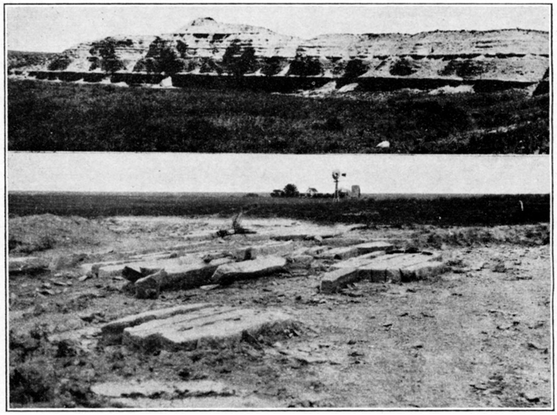
Plate V—Upper: Lower Fairport chalky shale in sec. 29, T. 23 S., R. 24 W., Hodgeman County. Lower: "Fencepost" limestone quarry in the NE sec. 32, T. 22 S., R. 23 W., Hodgeman county.
Pfeifer Shale Member
The Pfeifer shale consists primarily of chalky shale, but also contains a chalky limestone at the top ("Fencepost" limestone) and some thin chalk beds and limestone concretions. The "Fencepost" limestone has a brown seam in the middle which is not as prominent in this area as it is farther northeast. This limestone forms a terrace, and beds of concretions eight feet below form a shoulder upon weathering. The Pfeifer shale member is never as prominent topographically as time underlying Jetmore chalk member. It weathers to a tan or cream color.
| Section of Pfeifer Shale Member in sec. 19, P. 21 S., ft. 25 W., on the Charles Jackson Ranch. | Ft. | In. |
|---|---|---|
| 10. Tan chalky limestone ("Fencepost" limestone) | 0 | 8 |
| 9. Light-gray limy shale with three zones of concretions | 4 | 11 |
| 8. Soft chalky limestone | 0 | 4 |
| 7. Brown granular calcite ("sugar sand") | 0 | 5 |
| 6. Chalky shale | 0 | 6 |
| 5. Chalky limestone | 0 | 2 |
| 4. Bentonite | 0 | 2 |
| 3. Light tan chalky shale with five thin zones of concretions | 5 | 3 |
| 2. Soft, chalky limestone | 0 | 3 |
| 1. Gray and light tan chalky shale with four zones of concretions | 6 | 7 |
| Top of Jetmore chalk member | ||
The member is 19 feet thick in western Hodgeman County and 21 feet thick in eastern Ness County. The beds are remarkably persistent, and can be traced for several hundred miles. The zone of granular calcite (bed 7) is called "sugar sand" by core drillers, because when fresh it has the texture and color of sugar. In core holes the "Fencepost." limestone is identified by its relation to tile bentonite and granular calcite bed in the lower Fairport chalky shale (bed 2) and the "sugar sand" in the upper Pfeifer shale member. This makes an excellent marker, and since most of the surface structure mapping is done on the "Fencepost" limestone, the surface and subsurface data fit together readily.
The Pfeifer shale member crops out along Alexander Dry Creek in eastern Ness County and along Walnut Creek from Ness City east to the east side of the county. The outcrop of the member follows both sides of Pawnee River in both counties as far west as sec. 10, T. 22 S., R. 26 W., near the west side of Hodgeman County. It crosses the divide between Pawnee River and Buckner Creek north of Hanston, makes a reentrant to the west along Dry Creek and then follows the north side of Buckner Creek from three miles west of Hanston to eight miles invest of Jetmore, and then follows the south side of the creek to three miles southeast of Jetmore where it is overlapped by the Ogallala formation. A small inlier of Pfeifer shale occurs in see. 30, T. 23 S., R. 25 W.
Jetmore Chalk Member
The Jetmore chalk member consists of a series of chalky limestone beds three to six inches thick separated by chalky shales from one to two feet thick. The member is capped by a hard, fossiliferous, chalky limestone one foot thick. This bed is the hardest bed in the Greenhorn limestone in this area and is called "shell rock," because of the abundance of the pelecypod Inoceramus labiatus in it. The chalky limestones of this member weather to white or light tan and the shales to tan or orange-tan.
The Jetmore is the most resistant part of the Greenhorn limestone. Everywhere it makes a prominent terrace, and in almost all cases exposures are covered with talus. Valleys are narrow where they cut through this member, widening out above in the Pfeifer shale and below in the Hartland shale. The "shell rock" breaks into large slabs which cover the slopes below. Exposures half a mile south of Jetmore, the type locality, are typical of the member. The Jetmore chalk member is 22 feet thick south of Jetmore.
| Section of the Jetmore Chalk Member One-half Mile South of Jetmore (Type Locality) | Ft. | In. |
|---|---|---|
| 25. Hard, fossiliferous chalky limestone. The upper four inches is concretionary. ("Shell rock") | 1 | 1 |
| 24. Tan, fossiliferous chalky shale with two zones of flat concretions | 3 | 0 |
| 23. Chalky limestone | 0 | 3 |
| 22. Chalky shale | 1 | 2 |
| 21. Chalky limestone | 0 | 5 |
| 20. Tan chalky shale | 1 | 0 |
| 19. Hard chalky limestone | 0 | 5 |
| 18. Tan chalky shale | 1 | 0 |
| 17. Chalky limestone | 0 | 2 |
| 16. Tan chalky shale | 1 | 1 |
| 15. Lenticular chalky limestone | 0 | 3 |
| 14. Tan chalky shale | 1 | 0 |
| 13. Hard chalky limestone | 0 | 4 |
| 12. Tan chalky shale with thin chalk bed one foot above base | 2 | 3 |
| 11. Hard chalky limestone | 2 | 9 |
| 10. Chalky shale | 1 | 0 |
| 9. Chalky limestone | 0 | 6 |
| 8. Tan chalky shale | 1 | 2 |
| 7. Soft chalky limestone | 1 | 3 |
| 6. Tan chalky shale | 1 | 3 |
| 5. Chalky limestone | 0 | 6 |
| 4. Tan chalky shale | 1 | 4 |
| 3. Chalky limestone | 0 | 5 |
| 2. Tan chalky shale | 1 | 4 |
| 1. Chalky limestone | 0 | 4 |
| Total | 22 | 6 |
The beds are very persistent laterally. A section measured in Russell County has identical beds, but the thickness of the member is less. The same applies to sections in Osborne County (Landes, 1930, p. 13), where the thickness is 17 feet, and in Cloud County (Wing, 1930, p. 27), where the thickness is 12 feet.
The Jetmore chalk member crops out immediately east of the Pfeifer shale member where the latter is present. The outcrop follows the Pfeifer shale in Ness County and in northern and western Hodgeman County and is present south of Buckner Creek east of Hanston, but is overlapped by the Ogallala formation south of this locality in Hodgeman County, although it is present in Ford County just south of the Hodgeman County line.
Hartland Shale and Lincoln Limestone Members
The two lowest members of the Greenhorn limestone cannot be satisfactorily differentiated in Ness and Hodgeman counties. Their upper part consists of calcareous shale with thin, chalky, limestone beds. The lower part is chalky shale with thin crystalline limestone beds. The latter are characteristic of the two members, especially toward the base. Shale predominates in the lower Greenhorn. No lithologic break at which the two members may be separated occurs in the area under discussion. The upper part of the Lincoln-Hartland beds weathers to light tan or gray and the lower part to orange-tan or buff. A few bentonite beds from one to five inches thick are present.
The upper part of the Lincoln-Hartland beds is rarely exposed and forms a gentle soil-covered slope below the Jetmore chalk member. The lower 10 to 15 feet forms a terrace, or shoulder, because the thin crystalline limestones are hard and the underlying Graneros shale is very soft. Exposures of the lower part are usually covered by thin, tan-colored slabs of crystalline limestone that emit a petroliferous odor when freshly broken.
The thickness of the two members is 80 feet in sec. 5, T. 25 S., R. 24 W., northern Ford County. Here there are no limestone beds over five inches thick and the limestones in the lower part are less than three inches thick. About 20 feet below the base of the Jetmore is a five-inch chalky limestone that has been quarried for building stone.
The Hartland and Lincoln members are not exposed in Ness County. However, the Hartland shale, at least, must be present where Pawnee River leaves the county but is covered by alluvium. Exposures occur in Hodgeman County along Dry Creek and along Buckner Creek from Jetmore eastward. The best exposures of the lower part are along Sawlog Creek, from Hanston to the south line of the county.
Graneros Shale
The Graneros formation consists of bluish-gray, noncalcareous clay shale with a few beds of sandstone and sandy shale. The lithology is variable. In some places the formation is all shale, but in others it may be half sandstone and sandy shale. The formation is marked at the top by a sharp lithologic break due to the abrupt change to the calcareous beds of the Greenhorn limestone. At the base of the formation, however, there is usually a transitional zone overlying the Dakota sandstone.
The Graneros shale usually forms a slope between the Greenhorn limestone and the Dakota sandstone. If the slope is covered by a thin layer of soil the vegetation is poor, as the shale does not produce a good soil. Exposures are best where resistant beds in the overlying Lincoln member of the Greenhorn limestone have formed a terrace. The outcrop is strewn with selenite crystals in many cases.
| Detailed Section of the Graneros Shale in sec 24, T. 22 S., R. 22 W. | Ft. | In. |
|---|---|---|
| 5. Bluish-gray, fissile, slightly gritty clay shale containing a few brownish sandy streaks and thin gray sandstone lenses containing Callista tenuis | 18 | 8 |
| 4. Rusty, thin-bedded shaly sandstone | 1 | 2 |
| 3. Fissile gray shale containing abundant selenite and sulphur-yellow sandy streaks | 8 | 0 |
| 2. Fissile, bluish-gray gritty shale containing some selenite | 5 | 6 |
| 1. Sand and shale with abundant selenite at top. The lower part is gray and contains sandstone lenses. The upper part is a brownish sandy shale | 8 | 0 |
| Total | 36 | 1 |
The thickness of the Graneros is variable, ranging from 21 to 36 feet in this area. The above section shows typical lithology but is thicker than the average.
The only fossils found in the Graneros shale in this area were Callista tenuis and Exogyra columbella. More may occur here, however, as there are many other pelecypods and gastropods and ammonites found at other localities.
The variable thickness of the Graneros shale is probably due to its having been deposited on a slightly irregular surface. The underlying Dakota sandstone is mostly a nonmarine or littoral deposit, so the Graneros sea advanced over a sand-covered area which had a slightly irregular surface. This irregular surface may have been due to uneven deposition, or erosion of the top of the sandstone, or to compaction of shale within the Dakota around or over sand lenses. The sea floor was covered with muds of the Graneros formation which contained sands derived from the underlying Dakota sandstone.
Dakota Sandstone
The oldest formation outcropping in the area is the Dakota sandstone. Only the upper 50 or 60 feet of the formation is exposed and this occurs in the south and east part of Hodgeman County. The formation is composed of lenticular sandstone beds and variegated shales. The sandstones are usually cross-bedded. No regular or persistent beds were noted. The sandstone may be cemented with calcium carbonate or with iron oxide. The beds that are cemented by iron oxide are usually harder than the others. Such a bed occurs at the top of the formation in the northwest part of T. 24 S., R. 22 W., where it forms a terrace about a quarter of a mile wide south of Sawlog Creek.
Most of the area where the Dakota formation crops out is in gentle soil-covered slopes. Only the hardest beds, which are in the minority, are exposed. Since the parts of the Dakota sandstone that are exposed in most places are the hard sandstone beds, the formation is usually thought to be almost entirely composed of sandstone. However, well logs show that the formation is only about one-fourth sandstone.
Well logs in this area show the Dakota formation to be 350 to 450 feet thick. This thickness includes beds from the base of the Graneros shale to the top of the Permian red beds and may include, in the lower part, beds of Lower Cretaceous age which correlate with the Kiowa shale and Cheyenne sandstone exposed in the southern part of Kansas.
The Dakota sandstone crops out from Rock Creek, east of Jetmore, to the south line of Hodgeman County, along Sawlog Creek, and along the south side of Buckner Creek east of Hanston to the east line of the county. Small exposures occur on the north side of Buckner Creek in the vicinity of Hanston. The valley of Pawnee River is cut into the Dakota sandstone near the east line of Hodgeman County, but there are no exposures as the alluvium covers all of the bedrock.
No fossils were found in the formation in Hodgeman County, but plant fossils and brackish water pelecypods and gastropods occur in it elsewhere.
Prev Page—Geography || Next Page—Buried Rocks
Kansas Geological Survey, Ness and Hodgeman Geology
Comments to webadmin@kgs.ku.edu
Web version May 2004. Original publication date Dec. 1, 1932.
URL=http://www.kgs.ku.edu/General/Geology/Ness/04_expos.html