![]()
Prev Page--Subsurface Water || Next Page--Regions
Geologic Formations and Their Water-bearing Characteristics
Pennsylvanian System
Wabaunsee Group
Cedar Vale Shale, Rulo Limestone, and Silver Lake Shale
The Cedar Vale shale, Rulo limestone, and Silver Lake shale, which will be considered as a single unit in this report, crop out in a few of the deepest valleys in eastern Jackson County. The greatest combined thickness of these formations exposed in Jackson County is near the center of sec. 32, T. 9 S., R. 16 E., where nearly 50 feet is exposed. The Elmo coal of the Cedar Vale shale and the Rulo limestone are covered at this location. The predominant materials here are bluish- to yellowish-brown sandy shale and shaly to massive sandstone.
The Elmo coal crops out and has been mined along a creek bank about 1 mile south of Larkinburg. The coal is about 14 inches thick and is separated from the overlying Rulo limestone by 4 inches of shale. The Rulo limestone at this outcrop is nearly black, very fossiliferous, and badly weathered; its thickness is slightly less than 1 foot.
Small quantities of water may be available from sandstone within the Cedar Vale shale and Silver Lake shale, but few wells are known to obtain significant quantities of potable water from these formations.
Burlingame Limestone, Soldier Creek Shale, and Wakarusa Limestone
These formations are well exposed over much of eastern Jackson County, but in many places where the Soldier Creek shale is thin it is difficult to distinguish between the Burlingame limestone and the Wakarusa limestone.
The Burlingame limestone is deep brown and thick-bedded. In many exposures it has an unusual mottled and brecciated appearance, being composed of light-brown limestone fragments in a rusty-brown matrix. Small calcite veinlets are common throughout the formation. Algal remains are abundant in the upper part. The Burlingame limestone ranges from 6 to 10 feet in thickness.
The lithology of the Soldier Creek shale is variable. Dark tan, green, gray, and streaks of red are the most common colors. Fossils are not numerous, but in some places crinoids are found just below the Wakarusa limestone. The maximum thickness of the Soldier Creek shale in Jackson County is 9 feet.
The Wakarusa limestone is a hard blue-gray massive crystalline limestone about 2.5 feet thick. Fusulinids, large algae, brachiopods, and other fossils are present in the limestone. After prolonged weathering the outcrop becomes brown, and large rectangular blocks break off.
The Burlingame limestone and the Wakarusa limestone are not major sources of water in Jackson County; however, limited supplies of water suitable for domestic use can be obtained by wells penetrating the formations. The Soldier Creek shale does not yield water to wells in Jackson County.
Auburn Shale
The Auburn shale consists largely of gray shale which contains small amounts of impure sandstone and limestone. Nearly all exposures show a few inches to several feet of black platy shale near the center of the formation. The Auburn shale ranges from 25 to 50 feet in thickness. It does not yield appreciable amounts of water to wells in Jackson County.
Reading Limestone
The Reading limestone is a dark-blue hard limestone in three massive beds. Crinoid stems and a few pelecypods are the only conspicuous fossils. The characteristic thickness of the Reading limestone is about 2 feet.
The Reading limestone is known to yield water only to a few shallow dug wells where the limestone is near the surface.
Harveyville Shale
The Harveyville shale is a calcareous greenish-gray blocky shale ranging in thickness from 9 to 15 feet. No wells are known to obtain water from the Harveyville shale in Jackson County.
Elmont Limestone
The Elmont limestone comprises three or four limestone beds separated by shale layers. The lower limestone bed is massive and has prominent vertical joints. The shale beds are calcareous and greenish gray. In many exposures the two upper limestone beds have a conglomeratic appearance and contain numerous fusulinids. The average thickness of the Elmont limestone is about 3 feet. It supplies a small amount of water where it is not too deeply buried under younger rocks.
Willard Shale
Shale is the predominant material of the Willard shale but impure cross-bedded sandstone is common in the upper part. The shale is dark gray to brown and is not generally fossiliferous. Locally, a coaly streak occurs near the top of the formation. The average thickness of the formation in Jackson County is 35 feet.
The Willard shale is not a significant aquifer in Jackson County.
Tarkio Limestone
The Tarkio limestone is well exposed along its entire outcrop area and is one of the most easily recognized formations in Jackson County. The Tarkio limestone is a massive brown limestone in one or two beds. A multitude of large fusulinids stand out on a weathered surface and impart a very rough appearance. The Tarkio limestone ranges in thickness from 3 to 5 feet in Jackson County.
The Tarkio limestone does not yield appreciable amounts of water in Jackson County.
Pierson Point Shale
The Pierson Point shale is generally yellow in the lower part and dark gray to black in the upper part. Impure limestone and shaly sandstone are common in the upper one-half of the formation. The thickness ranges from 13 to 25 feet in Jackson County.
The Pierson Point shale is of little consequence as an aquifer.
Maple Hill Limestone
The Maple Hill limestone is generally a single bed of medium-hard gray limestone. Vertical jointing is prominent and in the outcrop the limestone usually weathers to a deep red. Slender fusulinids are numerous in most exposures. The thickness of the Maple Hill limestone is 1 to 2 feet.
The Maple Hill limestone supplies small quantities of water to a few wells in Jackson County.
Langdon Shale
The Langdon shale is light brown and light blue-gray and has thin irregular sandstone beds throughout. The upper part in a few outcrops is a soft massive brown sandstone. The formation ranges in thickness from 35 to 45 feet.
The sandstone beds of the Langdon shale yield small supplies of water where not deeply buried in eastern and southern Jackson County.
Dover Limestone
The Dover limestone in Jackson County generally consists of a single massive bed of brown limestone containing large fusulinids and many algal remains. At a few exposures in Jackson County an upper bed of conglomeratic limestone is separated from the main bed by 2 to 3 feet of tan shale. The average thickness of the formation is about 3 feet.
The Dover limestone supplies only very small quantities of water to a few shallow dug wells in Jackson County.
Dry-Friedrich Shale
In Jackson County the Grandhaven limestone is absent or very inconspicuous, and the two shale formations which the limestone normally separates will be considered as a single unit called the Dry-Friedrich shale. Because the Dry-Friedrich shale is poorly exposed the total thickness could not be determined accurately but it is approximately 35 to 45 feet. The lower half of the unit is a sandy and micaceous yellow shale, the upper half of the unit is chiefly massive and cross-bedded sandstone and some sandy shale.
The sandstones of the upper part of the Dry-Friedrich shale yield small to moderate supplies of water to many wells in Jackson County.
Jim Creek Limestone
The Jim Creek limestone is exposed in only a few places in Jackson County. In every place the formation is a single bed of dark fossiliferous limestone about half a foot thick. Upon weathering the rock breaks down into small shelly chips.
The Jim Creek limestone is not an aquifer in Jackson County.
French Creek Shale and Pony Creek Shale
In Jackson County the Nebraska City limestone member is the only recognizable part of the Caneyville limestone.
The French Creek shale and the Pony Creek shale, being similar in water-bearing characteristics, are considered in this report as a single unit. The Nebraska City limestone member is included in this unit.
The French Creek shale averages about 20 feet in thickness. Gray to brownish-yellow sandy shale is the predominant material. Two thin but persistent coal beds occur near the top of the formation. Locally the lower coal bed is underlain by several feet of soft tan sandstone.
The Nebraska City limestone member is a soft impure tan limestone bed containing many shell fragments. The average thickness is slightly more than 1 foot.
The Pony Creek shale is distinguished chiefly by the presence of red shale in the lower part. Locally a soft massive sandstone occurs in the middle part and the upper part is a sandy and micaceous tan shale. The Pony Creek shale ranges from 14 to 20 feet in thickness.
Where local sandstones of considerable thickness are penetrated the French Creek and Pony Creek formations yield small quantities of water to a few domestic and stock wells in Jackson County.
Brownville Limestone
The Brownville limestone, the uppermost formation of the Pennsylvanian System in Kansas, is well exposed along most of its outcrop area in Jackson County. The Brownville occurs as one or two beds of soft rather impure tan to yellow limestone containing many well-preserved brachiopod shells. The formation ranges in thickness from 1 to 3 feet.
The Brownville limestone is of little consequence as an aquifer in Jackson County.
Permian System
Admire Group
Towle Shale
In Jackson County, the base of the Towle shale is not marked by a prominent unconformity as it is reported to be in many places in Kansas. The Indian Cave sandstone member was not recognized anywhere in the county. The average thickness of the Towle shale is about 15 feet. The lower half is typically red shale and the upper half, gray to tan shale.
The Towle shale supplies little or no water to wells in Jackson County.
Aspinwall Limestone
The Aspinwall limestone is a medium-hard gray limestone that becomes white upon weathering. Fossils are not commonly found in this formation and exposures have a tendency to weather into small chips. The thickness of the Aspinwall limestone is about 1 foot.
When not too deeply buried the Aspinwall limestone may yield very small quantities of water to wells.
Hawxby Shale
The Hawxby shale consists chiefly of gray blocky shale. Thin beds of lenticular impure limestone are present near the middle of the formation. The average thickness of the Hawxby shale is about 18 feet.
The Hawxby shale yields little or no water to wells in Jackson County.
Falls City Limestone
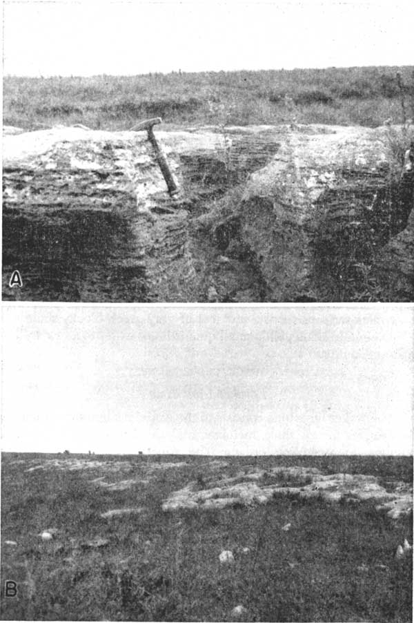
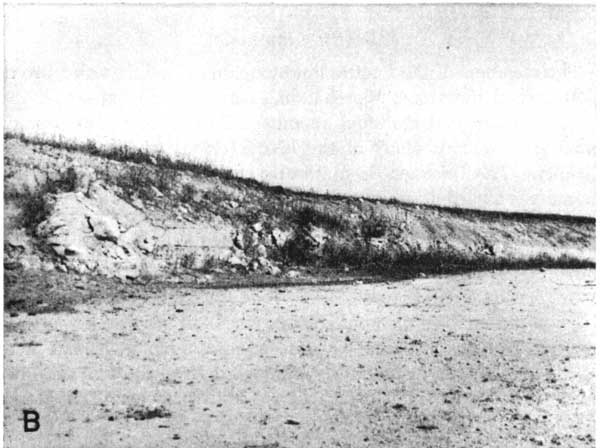
In Jackson County the Falls City limestone is the most distinctive formation of the Admire group. The exact thickness is not known, but the main limestone bed is about 3 feet thick. A thin bed of impure yellow limestone is found in some places about 4 feet below the main bed. The main bed is quite massive, and the many small shell fragments of which it consists gives it a very rough or coquina-like appearance. On weathered outcrops the vertical joints become greatly enlarged by solution (Pl. 6A), and large blocks of limestone are strewn down the slope from the outcrop (Pl. 6B). Small pelecypods are the most numerous fossils.
The Falls City limestone yields little or no water to wells in Jackson County.
Plate 6--Outcrops of the Falls City limestone. A, Outcrop in sec. 13, T. 9. S., R. 13 E. B, Typical outcrop of Falls City limestone; sec. 10, T. 9 S., R. 14 E.
West Branch Shale
The West Branch shale is poorly exposed in Jackson County. The formation is approximately 17 to 23 feet thick and consists of gray shale and shaly sandstone.
The West Branch shale yields little or no water to wells in Jackson County.
Five Point Limestone
The Five Point limestone consists of a single bed of hard brownish-gray limestone. Small fusulinids are numerous in most exposures. The formation is consistently just less than 1 foot in thickness.
The Five Point limestone yields little or no water to wells in Jackson County.
Hamlin Shale
The Hamlin shale consists of three members in ascending order: the Stine shale, Houchen Creek limestone, and Oaks shale. A massive sandstone bed occurs locally near the top of the Stine shale member. The poorly developed Houchen Creek limestone member consists of less than a foot of impure nodular limestone. The Oaks shale member consists of a few feet of gray-green blocky shale.
The Hamlin shale yields small quantities of water to a few wells in Jackson County.
Council Grove Group
Foraker Limestone
The Foraker limestone consists of the Americus limestone member, the Hughes Creek shale member, and the Long Creek limestone member, in ascending order. The Americus limestone member is a single bed of very hard blue limestone just less than 1 foot thick. Large crinoid stems are weathered in relief on many old exposures. The Hughes Creek shale member consists of 30 to 40 feet of yellow and dark-gray shale and impure yellow limestone. In a few exposures in Jackson County a great many fusulinids are present. In lithology the Long Creek limestone member ranges from hard limy shale to a series of cellular or honeycombed beds of limestone. The Long Creek limestone member ranges in thickness from 3 to 7 feet.
The Long Creek limestone member of the Foraker formation yields moderate amounts of water to domestic and stock wells in Jackson County.
Johnson Shale
The Johnson shale consists chiefly of gray shale, but the formation contains several impure limestone beds. The thickness of the formation is about 15 feet.
The Johnson shale is not an aquifer in Jackson County.
Red Eagle Limestone
The Red Eagle limestone, like most limestone formations of the Council Grove group, is composed of two limestone members and an intervening shale member. The lower limestone member, the Glenrock, is a fairly hard brown massive fusulinid-bearing limestone. The thickness ranges from 1 to 2 feet.
The Bennett shale member consists of 6 to 9 feet of shale and impure limestone. The lower part of the member, which contains numerous Orbiculoidea, is predominantly black in color. The upper part of the member is gray or light green.
The Howe limestone member is a massive bed of fine-grained limestone or siltstone. In a fresh exposure it generally has a splintered or fractured appearance. It is dark gray and fossils are rare. The member ranges in thickness from 2 to 4 feet.
The Red Eagle limestone yields a considerable amount of water to wells in western Jackson County. The Howe limestone member, which contains water in cracks, is the most important aquifer in the formation.
Roca Shale
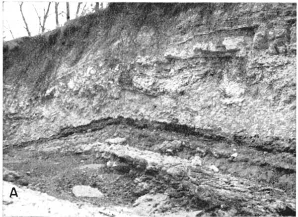
In Jackson County the Roca shale is about 18 feet thick and is composed chiefly of gray-green limy shale. Generally about 4 feet of red shale lies just below the center of the formation (Pl. 7A).
The Roca shale is not an aquifer in Jackson County.
Plate 7A--Exposure of Roca shale, NE NW sec. 16, T. 7 S., R. 13 E.
Grenola Limestone
The members of the Grenola limestone, in ascending order, are the Sallyards limestone, Legion shale, Burr limestone, Salem Point shale, and Neva limestone.
The Sallyards limestone member is a hard, rather brecciated-appearing bed generally less than 2 feet thick. The Legion shale member consists of 4 to 6 feet of gray and black fissile shale. The Burr limestone member is a single bed of medium-hard gray fossiliferous limestone about 4 feet thick, or, locally, two beds of limestone separated by about 4 feet of black shale. The Salem Point shale member ranges in thickness from 7 to 9 feet, and is composed chiefly of gray nonfossiliferous shale.
The Neva limestone member is a bench-forming unit composed of three to five limestone beds separated by shale beds. The main limestone bed, about 7 feet thick, weathers pitted or cavernous. The limestone beds are fossiliferous and ashy gray. The shale beds are gray but locally black in the lower part.
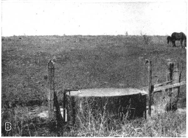
The Grenola limestone is one of the most important aquifers in Jackson County. The Neva limestone member, being somewhat cavernous, supplies relatively large quantities of water to many wells and springs in northwestern Jackson County (Pl. 7B).
Plate 7B--Flow of water from spring issuing from the Neva limestone member of the Grenola limestone; SW SE sec. 28, T. 7 S., R. 14 E.
Eskridge Shale
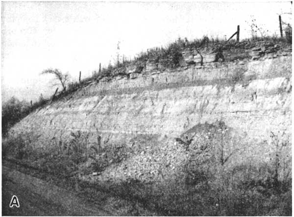
The Eskridge shale is red or pink in the lower part and pale green or gray in the upper part. A zone of impure limestone beds separates the upper and lower parts of the formation (Pl. 8A). Fossils are not common in the Eskridge shale. The thickness is uniformly about 34 feet.
The Eskridge shale yields little or no water to wells in Jackson County.
Plate 8A--Eskridge shale and Cottonwood limestone members of the Beattie formation; in road cut, SE SE sec. 34, T. 6 S., R. 13 E.
Beattie Limestone
The members of the Beattie limestone, in ascending order, are the Cottonwood limestone, Florena shale, and Morrill limestone.
The Cottonwood limestone member forms a prominent bench in outcrops and caps many of the higher ridges in western Jackson County. The thickness is uniformly about 6 feet (Pl. 8B). The member is a hard massive buff limestone that weathers almost white. Fusulinids are plentiful, and elongated nodules of brown chert weathering in relief impart a very distinctive appearance. Springs and seeps issuing at the base of the limestone support heavy growths of vegetation along the outcrop.
Plate 8B--Upper part of Cottonwood limestone member; in quarry, SE SW sec. 27, T. 7 S., R. 13 E.
The Florena shale member consists chiefly of gray shale, but small amounts of black shale are not uncommon. Thin shell beds of the brachiopod Chonetes granulifer are interspersed through the lower part; they are the only conspicuous fossils present. The Florena shale member ranges in thickness from 6 to 10 feet.
The Morrill limestone member is a nonresistant brown limestone containing much crystalline calcite. On weathered exposures the limestone is almost entirely weathered away, and only large masses of calcite or calcite-lined cavities remain. The Morrill limestone member is about 3 feet thick.
The Beattie limestone is probably the best aquifer in Jackson County where it has a favorable topographic position. The Cottonwood limestone member is the chief water bearer, the water being contained in joints and solution channels. In general, even extended droughts have little effect upon wells deriving their water from the Cottonwood. In many wells the Morrill limestone member is probably an aquifer supplementing the Cottonwood. The Florena shale member is not significant as an aquifer.
Stearns Shale
The Stearns shale consists of about 20 feet of gray or pale-green calcareous shale. One or two white chalky limestone beds less than 1 foot thick are present in most exposures.
The Stearns shale yields little or no water to wells in Jackson County.
Bader Limestone
The Bader limestone is composed of the Eiss limestone member, Hooser shale member, and Middleburg limestone member. The Eiss limestone member is the first resistant bed above the Cottonwood limestone and forms a prominent bench. The Eiss is a massive limestone which weathers slightly platy and pitted. It is creamy tan and contains very few fossils. The thickness ranges from 3 to 4 feet.
The Hooser shale member consists of 9 to 12 feet of moderately fossiliferous shale. A large part of the shale is tan but the lower third is locally mottled with streaks of red. The Middleburg limestone member is not as resistant as the Eiss limestone member and generally does not form a prominent bench. The Middleburg limestone member is a yellowish-tan platy-weathering fossiliferous limestone. The upper few inches are generally almost black. The average thickness of the Middleburg is 12 feet.
The Eiss and Middleburg limestone members of the Bader limestone yield small amounts of water to wells. The Hooser shale member is not significant as an aquifer.
Easly Creek Shale
In Jackson County the Easly Creek shale is predominantly light colored, except for a red zone in the center. The Easly Creek shale ranges in thickness from 15 to 20 feet.
It does not yield water to wells in Jackson County.
Crouse Limestone
The Crouse limestone consists of a massive lower bed of gray limestone and upper beds of platy darker limestone. Fossil fragments that weather in relief impart a somewhat rough appearance to the outcrop. The greatest thickness of the Crouse limestone observed in Jackson County was 4 1/2 feet, but this thickness probably was reduced considerably by solution.
The Crouse limestone yields small quantities of water to a few shallow dug wells in Jackson County.
Blue Rapids Shale
The Blue Rapids shale is not well exposed anywhere in Jackson County. The interval between the top of the Crouse limestone and what was judged to be the base of the Funston limestone is about 22 feet. Several impure limestone beds occur near the top of the interval; however, they may belong to the lower part of the overlying Funston limestone.
The Blue Rapids shale yields little or no water to wells in Jackson County.
Funston Limestone
In Jackson County the Funston limestone consists of 5 feet of limestone and shale. The upper bed is 2 feet of hard massive blue-gray limestone. The remaining lower 3 feet is light-colored shale and impure platy limestone. The massive upper limestone bed breaks off in large blocks that slip down the hillsides and cover the lower part of the formation.
The Funston limestone, owing to its high topographic position and limited areal distribution, yields very little water to wells in Jackson County.
Speiser Shale
The lower 12 to 14 feet of the Speiser shale consists of varicolored shale, dark at the base, red, pink, and green in the center, and gray near the top. Above the varicolored shale is about 1 foot of hard crystalline gray limestone overlain by 3 feet of gray fissile shale.
The Speiser shale yields little or no water to wells in Jackson County.
Chase Group
Wreford Limestone
The Threemile limestone member is the only member of the Wreford limestone present in Jackson County. The Threemile limestone member occurs in only a few small areas in the extreme western part of the county. In these areas the limestone is weathered away and only a bed of irregular chert nodules remain.
The Threemile limestone member, which is a good aquifer in other parts of Kansas, does not yield water to wells in Jackson County owing to its unfavorable topographic position.
Quaternary System
Pleistocene Series
Pre-Kansan Gravel
Deposits of gravel composed largely of chert but containing a small amount of quartzite and quartz rest directly on Paleozoic bedrock and are overlain by the Atchison formation or by till at many places in northern Jackson County. These gravel deposits are considered to be of Pleistocene age because of the quartzite they contain; they can be distinguished from the Atchison formation by the larger percentage of chert they contain. In Jackson County the average thickness of these gravel deposits, which in this report are classified as pre-Kansan, is about 6 feet. The pre-Kansan gravel deposits are highly permeable, but owing to their patchy occurrence and relative thinness they do not furnish large quantities of water to wells in Jackson County.
Atchison Formation
The Atchison formation, which was deposited as pro-Kansan outwash, overlies the bedrock or pre-Kansan gravels and underlies Kansas till in much of northern Jackson County. The basal part of this formation consists of 1 to 20 feet of coarse sand and fine to medium quartz, quartzite, and chert gravel. The basal part of the Atchison formation yields adequate supplies of water to many stock and domestic wells in Jackson County.
The upper part of the Atchison formation consists of as much as 100 feet of very fine quartz sand and silt. The upper part of the formation is often called quicksand by water-well drillers because of the difficulty experienced with caving of the sand.
Kansas Till and Associated Deposits
Glacial deposits consisting of till and material deposited by glacial meltwater are the most widespread geologic formations in Jackson County. The greatest thickness of these materials is found in the northern part of the county, where more than 150 feet was penetrated in one test hole.
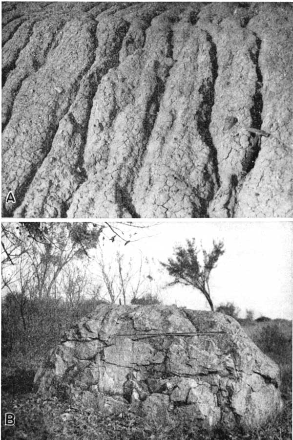
Till is the predominant material of the glacial deposits (Pl. 9A). The till is in three intergradational zones caused by different degrees of weathering. The upper zone, which averages about 12 feet in thickness, is non-calcareous and is tan or gray in color. In this zone the till is oxidized and leached of its calcareous material. The second zone is slightly darker than the first zone and the material is calcareous. Here the till is oxidized but is not leached. The base of this zone generally lies at a depth of 40 to 60 feet. The lower till zone contains fresh or unaltered till. The fresh till is dark blue when damp and is very calcareous. Fresh till is rarely found in a natural exposure. The till consists largely of clay and varying amounts of sand, gravel, and boulders (Pl. 9B). The coarser materials consist mainly of limestone, sandstone, granite, and quartzite. Till, because of its low permeability, is a very poor aquifer.
Plate 9--A, Glacial till in road cut, SE NE sec. 9, T. 6 S., R. 14 E. B, Glacial erratic in the SW NW sec. 6, T. 6 S., R. 13 E.
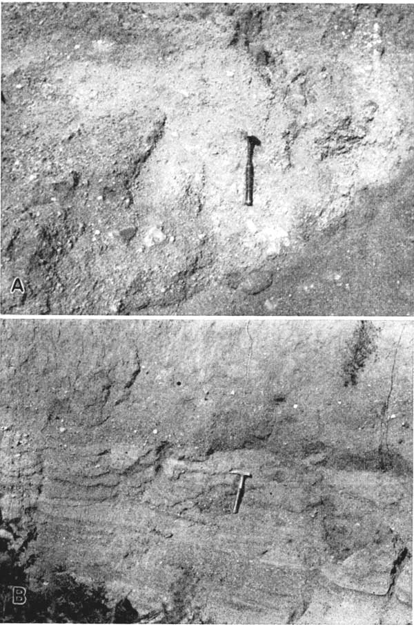
The glacial meltwater or glacioaqueous deposits are predominantly sand and gravel containing varying proportions of silt and clay (Pl. 10). The glacioaqueous deposits are irregular bodies or lenses which may occur at any position within the till. Some of the glacioaqueous deposits are good aquifers, especially deposits composed of coarse sand and gravel containing a minimum of silt and clay. A small glacioaqueous deposit surrounded by relatively impermeable till and not connected to other extensive glacioaqueous deposits may fail as an aquifer because of insufficient recharge. The presence or absence of glacioaqueous deposits cannot be determined except by drilling; however, most wells or test holes drilled in an area of thick glacial drift will penetrate one or more such deposits. Although the permeability and thickness of glacioaqueous deposits differs greatly, most farm and domestic wells penetrating these deposits have adequate yields. It is unlikely that industrial or municipal wells could be developed in any of the deposits.
Plate 10--A, Deposit of glacial sand and gravel, SE sec. 29, T. 6 S., R. 14 W. B, Sand and gravel interstratified with Kansas till; SW NW sec. 27, T. 6 S., R. 14 E. (Photo by A.R. Leonard, June 1949.)
Alluvium
The alluvium of the streams in Jackson County is of late Pleistocene (Recent) age and consists of sand, gravel, silt, and clay. The upper part of the alluvium consists of silt and clay containing a small amount of sand. The lower part of the alluvium is composed of sand and gravel and thin beds of clay. The alluvium of the major streams in Jackson County yields moderately large quantities of water to wells, and the alluvium of many of the minor tributary streams yields supplies adequate for domestic or stock needs.
Prev Page--Subsurface Water || Next Page--Regions
Kansas Geological Survey, Geology
Placed on web Aug. 9, 2007; originally published June 1953.
Comments to webadmin@kgs.ku.edu
The URL for this page is http://www.kgs.ku.edu/General/Geology/Jackson/06_form.html