![]()
Prev Page--Introduction || Next Page--Geology
Geography
Topography
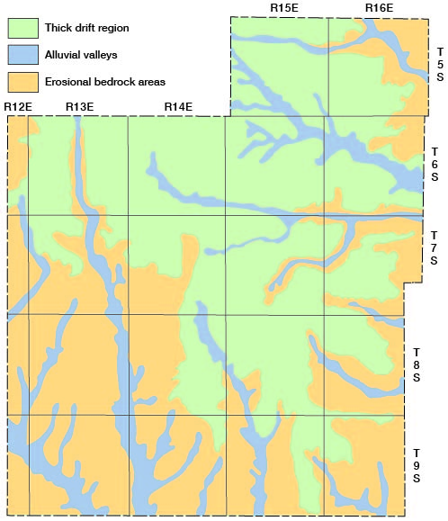
Jackson County lies in the Dissected Till Plains section of the Central Lowlands physiographic province (Schoewe, 1949). The county has three principal types of topography (Fig. 3) which are discussed below.
Figure 3--Map of Jackson County showing topographic divisions.
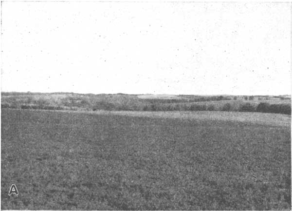
Thick drift Region--More than one-third of the area of Jackson County consists of an erosion surface on thick glacial drift (Pl. 4A). In this region the surface topography is not affected by the bedrock. The divide areas are smooth or gently undulating. Near the streams, dissection is more pronounced and the hills slope uniformly to wide rounded valleys. The average local relief of this area does not exceed 40 feet.
Plate 4A--Glacial topography of northern Jackson County.
Alluvial valleys--The numerous alluvial valleys of Jackson County have an average width of about half a mile, and they constitute about 13 percent of the area of the county.
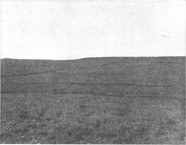
Erosional bedrock area--The bedrock crops out in the western, southern, and eastern parts of the county. Although glaciated, this area is sparsely covered with isolated patches of till, outwash, and erratic boulders. Parts of this area are extensions of the Attenuated Drift Border section of the Central Lowlands province. The relief of the erosional bedrock area is more pronounced than that of the thick drift region (Pl. 4B). The hills have flattened tops and steep sides similar to those of the Flint Hills region farther south.
Plate 4B--Bedrock topography in the NW sec. 15, T. 9 S., R. 14 E.
Drainage
The surface of Jackson County slopes gently to the southeast. The larger streams in the eastern part of the county flow in a general direction slightly south of east, whereas those in the western and southern parts of the county flow nearly straight south.
Big Soldier Creek is the longest stream in Jackson County. The stream enters the county 4 miles east of the northwest corner and leaves the county 8 miles east of the southwest corner. Cross Creek drains the extreme southwestern part of the county, its course roughly paralleling the Jackson-Pottawatomie county line. Walnut Creek and Little Soldier Creek have their headwaters in the Pottawatomie Indian Reservation and join Big Soldier Creek in Shawnee County. Mud Creek drains the southeastern corner of the county and flows into Kansas River. North Cedar Creek and South Cedar Creek are minor tributaries to Delaware River. Elk Creek, Spring Creek, and Muddy Creek are major tributaries to Delaware River, which flows through the northeastern corner of the county.
Climate
According to the 1948 report of the Kansas State Board of Agriculture, Jackson County has an average growing season of 183 days. The average date of the first killing frost in the fall is October 17, and the average date of the last killing frost in the spring is April 23. The normal monthly precipitation for the period 1898 through 1945 is shown in Table 1. The normal annual precipitation at Holton is 32.01 inches.
Table 1--The normal monthly precipitation for the period 1898 through 1945 at Holton, Kansas.
| Month | Precipitation, inches | Month | Precipitation, inches |
|---|---|---|---|
| Jan. | 0.87 | July | 3.18 |
| Feb. | 1.03 | Aug. | 4.20 |
| Mar. | 1.76 | Sept. | 4.01 |
| Apr. | 2.75 | Oct. | 2.45 |
| May | 4.46 | Nov. | 1.85 |
| June | 4.40 | Dec. | 1.05 |
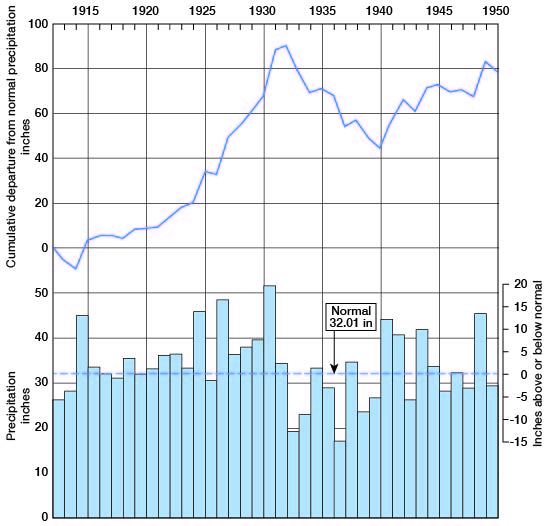
The annual precipitation and the cumulative departure from normal precipitation at Holton for the period 1902 through 1950 are shown in Figure 4. The normal annual mean temperature of Jackson County is 54.9 degrees. The ground is covered with snow an average of 30 days per year.
Figure 4--Annual precipitation and the cumulative departure from normal precipitation at Holton, Kansas.
Agriculture
Jackson County is primarily an agricultural county. In 1945 there were 1,985 farms in the county. In 1948 these farms had livestock valued at $5,815,800 and produced crops valued at $6,512,170. The total assessed valuation of farm land in 1946 was $14,965,755, ranking the county twenty-first in Kansas.
The approximate land area of Jackson County is 419,840 acres. In 1948, 158,000 acres were in tame and prairie grass pasture. The chief pasture area is in the southwestern part of the county where topographic relief and pronounced bedrock outcrops make tilling of the soil impractical. No irrigation is practiced in Jackson County. The comparative value of the agricultural products of Jackson County for 1948 is shown in Table 2.
Table 2--Comparative values of the agricultural products of Jackson County for 1948.
| Crops produced in 1948 | Livestock on farms 1948 | ||||
|---|---|---|---|---|---|
| Crop | Acres | Value | Livestock | Number | Value |
| Corn | 59,300 | $2,741,400 | Cattle (other than milk cows) | 24,600 | $2,545,000 |
| Wheat | 47,700 | 2,141,000 | Milk cows | 11,000 | 1,804,000 |
| Oats | 20,980 | 395,620 | Swine | 21,300 | 888,300 |
| Hay | 40,760 | 950,110 | Chickens | 233,800 | 280,600 |
| Sorghum | 7,500 | 213,060 | Horses and mules | 5,250 | 220,500 |
| Others | 11393 | 70,980 | Sheep and lambs | 5,010 | 76,700 |
| Total | $6,512,170 | Total | $5,815,800 | ||
Transportation
The Union Pacific Railway Company line between Topeka and Marysville crosses through the southwestern corner of Jackson County, passing through Delia. The Chicago, Rock Island, and Pacific Railroad passes through Hoyt, Mayetta, Holton, and Whiting, connecting Topeka with St. Joseph, Missouri. A branch of the Missouri Pacific Railroad passes through the northern tier of townships in the county, serving Whiting and Netawaka.
The county is served by five State highways, K9, K16, K116, K62, and K79, as well as by U. S. Highway 75; all are surfaced with black top. Most mail route roads, which are maintained by the, county are graded and surfaced with gravel or crushed limestone. Some of the least-used roads in areas of greatest topographic relief have been abandoned.
Population
Jackson County had a population of 11,098 in 1950 and an average density of population of 16.9 to the square mile. The population of Jackson County increased rather rapidly from 1860 to 1900, then declined gradually to the present figure. The population of the cities, as reported by the 1950 census, are as follows: Holton 2,705 Whiting 267; Mayetta 247; Hoyt 246; Netawaka 213; Soldier 193 Circleville 169; Denison 166; and Delia 164.
Natural Resources
The natural resources of Jackson County have been utilized for more than 60 years. The eighth biennial report of the Kansas State Board of Agriculture, 1891-92, devoted a paragraph to the discussion of the availability of building stone in Jackson County.
The known mineral resources of Jackson County consist of limestone, sand and gravel, and coal. Neither gas nor oil is produced in Jackson County.
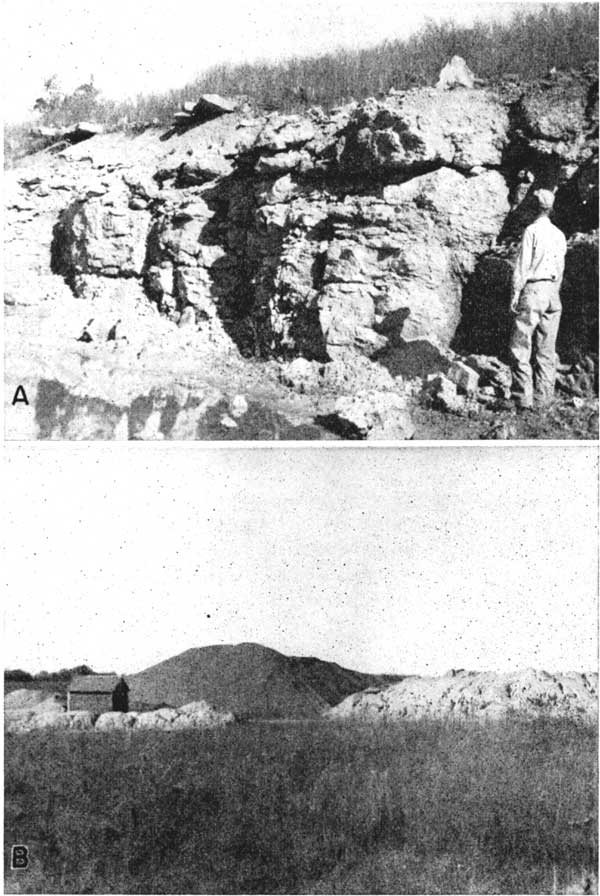
Limestone--Jackson County has limestone suitable for nearly every use. The Cottonwood, Neva, Americus, Tarkio, Reading, and Wakarusa limestones have been quarried in Jackson County for building stone but no building-stone quarries are now being operated in the county. The above-mentioned units, as well as the Burlingame limestone, have been quarried and crushed for use as road-building material or agricultural lime. Several large quarries and crushing plants now operate in Jackson County (Pl. 5.).
Plate 5--A, Quarry in Burlingame limestone near Mayetta. B, Stockpile of agricultural lime and road material at quarry near Mayetta.
Sand and gravel--Two sand and gravel pits in northwestern Jackson County are being operated as a source of road surfacing material. These deposits are of glacial origin and consist of unsorted sand and gravel mixed with clay and boulders. A gravel deposit in northeastern Jackson County consists principally of coarse brown chert gravel mixed with sand and clay. This deposit, which is no longer worked, probably is of pre-Kansan age.
Coal--Very little coal has been mined in Jackson County. Only three small drift mines 1 1/2 miles south and half a mile west of Larkinburg have been operated. Schoewe (1946) states that an area of about 2.5 square miles is underlain by a 14-inch coal bed containing about 2,800,000 tons of Elmo coal. He estimates the potential coal reserve in the county as approximately 191,500,000 tons. The coal averages about 12 inches in thickness and underlies an area of about 200 square miles.
Prev Page--Introduction || Next Page--Geology
Kansas Geological Survey, Geology
Placed on web Aug. 9, 2007; originally published June 1953.
Comments to webadmin@kgs.ku.edu
The URL for this page is http://www.kgs.ku.edu/General/Geology/Jackson/03_geog.html