![]()
Prev Page--Geology || Next Page--Ground water--Aquifer tests and Chemical character
Ground Water
Source
In Harper County, as well as in much of Kansas, ground water is derived almost entirely from precipitation. A part of the water that falls as precipitation becomes surface runoff, a part evaporates directly into the air, and a part is absorbed by plants and transpired into the air. The rest percolates downward through the soil and underlying strata until it reaches the water table, where it becomes ground water.
Occurrance
The rocks and surficial deposits that form the outer crust of the earth are not solid throughout, but contain numerous open spaces, called voids or interstices. It is in these spaces that water collects below the surface of the earth and from which it is recovered in part, through springs and wells. There are many types of rocks, and they differ greatly in the number, size, and arrangement of their interstices and, therefore, in their water-bearing properties. The occurrence of ground water in any region is thus determined by the geology of that region.
The interstices of rocks range from pores of microscopic dimensions to openings several feet wide. These interstices can be divided into two classes, primary interstices and secondary interstices. The primary or original interstices were formed during the formation of the rocks. Secondary interstices were developed by the different processes that affected the rocks after deposition. Several common types of interstices are shown in Figure 6. In Harper County all the water-bearing rocks are sedimentary in origin, and the openings that contain the water are either open spaces between the grains of rock (primary interstices) or joints, crevices, and open bedding planes that have resulted from deformation or solution of the rocks (secondary interstices).
Figure 6--Diagram showing several types of rock interstices and the relation of rock texture to porosity. A, Well-sorted sedimentary deposit having high porosity; B, poorly sorted sedimentary deposit having low porosity; C, well-sorted sedimentary deposit consisting of pebbles that are themselves porous, so that the deposit as a whole has a very high porosity; D, well-sorted sedimentary deposit whose porosity has been diminished by the deposition of mineral matter in the interstices; E, rock rendered porous by solution; F, rock rendered porous by fracturing. (From O.E. Meinzer.)
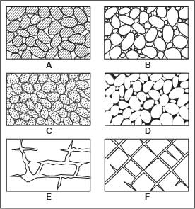
The amount of water that can be stored in any rock depends upon the porosity of that rock. Porosity is expressed quantitatively as the percentage of the total volume of the rock that is occupied by the interstices. When all the interstices in a rock are filled with water the rock is said to be saturated. The amount of water that a saturated rock will yield to the pull of gravity is known as the specific yield. Although the amount of water a rock contains is determined by its porosity, the amount of water a rock will yield to wells is determined by its permeability. The permeability is its ability to transmit water under a hydraulic gradient; it is measured by the rate at which a rock will transmit water through a given cross section under a given loss of head per unit of distance. Some beds of clay or shale may have a high porosity, but because the pores or openings are small and poorly connected they transmit little or no water and may be regarded as virtually impermeable. Rocks differ greatly in their degree of permeability according to the number, size, and interconnection of their interstices.
Ground water may occur under artesian or water-table conditions in the aquifer.
Artesian Conditions
Artesian conditions are said to exist where a permeable bed or zone of considerable lateral extent is saturated and is overlain by a bed or beds of impermeable or relatively impermeable material. The beds must dip from the outcrop area toward the discharge area. Water entering the water-bearing bed in the outcrop area percolates downward to the water table and moves downdip beneath the confining bed. The weight of the water at higher levels in the confined system creates a hydrostatic pressure in the ground-water reservoir. When the confining bed is penetrated, the water will rise in a drill hole to a level equal to the hydrostatic head in the aquifer at the point of discharge. If the head on the aquifer is sufficient to lift the column of water in the drill hole high enough to flow at the surface, the well is said to be a flowing artesian well.
Well 34-5-32abb (Table 10), which was drilled as a test hole for an oil-exploration survey, is an example of an artesian well. This well flowed when drilled but the head was sufficient to cause only a small surface flow. A pump was installed and the well then yielded enough water for stock use on several farms in the vicinity. The well is in a small valley at a low elevation in relation to the surrounding area. Other wells in the vicinity do not flow, although they probably obtain water from the same zone in the Permian rocks. Other flowing wells and test holes in this general area have been reported, but these wells either have been plugged or have stopped flowing. No flows of salt water have been reported in Harper County; all the well water is of a quality good enough for stock use.
Water-Table Conditions
Ground water may occur in an aquifer that is not overlain by a relatively impermeable bed. Under this condition the water is not confined, and the surface of the water within the aquifer is free to fluctuate up or down as water is added to or withdrawn from the aquifer. Ground water in such an aquifer is said to be under water-table conditions.
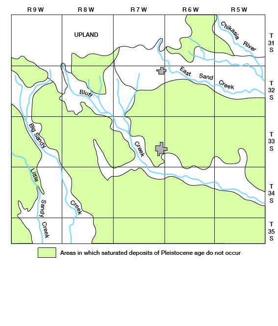
Harper County can be divided into six main areas as follows: The Upland area, which comprises somewhat less than three townships in the northwestern part of the county; the Bluff Creek area, which includes most of the drainage area of Bluff Creek, in which Pleistocene deposits occur; the Big Sandy Creek area in the western part of the county; the East Sand Creek area, which extends from a point west of Harper eastward to the edge of the county; the Chikaskia River area in northeast Harper County; and the Permian area, all the area in which Permian rocks crop out. These groundwater areas are shown in Figure 7.
Figure 7--Ground-water areas in Harper County, Kans.
Water Table and Movement of Ground Water
The upper surface of the zone of saturation in ordinary permeable soil or rock has been termed the ground-water table, or simply the water table. The water table is not a plane surface but has irregularities comparable with and related to those of the land surface although the water table generally is less rugged. Moreover, the water table does not remain in a stationary position, but fluctuates up and down. The irregularities are caused chiefly by local differences in geology and topography, and the fluctuations are due to additions of water to or withdrawals from the ground-water reservoir.
The shape of the water table in Harper County is indicated by contour lines on Plate 3. The contours were drawn for the Pleistocene deposits; the dashed lines show the inferred position of the water table in small areas of Permian deposits. No attempt was made to draw contours for the large areas of Permian deposits, as the water table probably is not continuous through these deposits. All points along a contour line have the same altitude, and the lines indicate the shape and slope of the water table just as similar lines on a topographic map show the land surface. The water moves downslope in a direction at right angles to the contours.
In the Upland area of Harper County (Fig. 7) the water moves south-southeast. Along the northern border of the county the water-table slope averages about 10 feet per mile and in the southern part about 40 feet per mile.
In the East Sand Creek area the water table slopes about 20 feet per mile in the western part and about 10 feet per mile in the eastern part. The water moves southeastward toward the edge of the county. The contours indicate that some water is being discharged from the aquifer into East Sand Creek east of Harper.
In the Bluff Creek and Chikaskia River areas the water-table contours bend sharply upstream near the streams, indicating discharge of ground water into these streams. In the Chikaskia River area the water table slopes toward the streams about 30 feet per mile or more; however, the slope of the stream is less than 10 feet per mile. In the Bluff Creek area the slope of the water table toward the stream is about 30 feet per mile above Anthony but only about 12 feet per mile below Anthony; however, the slope of the water table in the stream is about 12 feet per mile above Anthony and about 8 feet per mile below Anthony. In the Big Sandy Creek area the contours do not bend upstream as sharply as in the Bluff Creek and Chikaskia River areas, indicating that less water from the aquifer is being discharged into Big Sandy Creek than into Bluff Creek and Chikaskia River. The slope of the water table adjacent to Big Sandy Creek is about 8 feet per mile parallel with the stream.
Ground-water Recharge and Discharge
Precipitation is the principal source of recharge in Harper County. Only the Upland and Chikaskia areas (Fig. 7) receive recharge by subsurface inflow from outside the county. Along the north border of the Upland area some water probably moves into Harper County, but the quantity probably is small, as the ground-water divide is very near the county line. Some water moves from the northeast into the Chikaskia area.
In the upper reaches of the Big Sandy, Bluff Creek, and East Sand Creek areas, some recharge is derived from ground-water movement out of the Upland area. Along the southern border of the Upland area, many seeps and springs at the contact of the Kansan-Nebraskan deposits and the Permian rocks yield water during the spring and late fall. Water from these seeps and springs flows over the Permian rocks onto the permeable materials of the Big Sandy Creek, Bluff Creek, and East Sand Creek areas, and much of it returns to the ground-water reservoir in these areas.
Ground-water discharge is the water that leaves the ground-water reservoir through seeps and springs, by evaporation and transpiration, and by pumping from wells or infiltration galleries. Discharge by evaporation, transpiration, seeps, and springs is called natural discharge; discharge by pumping or natural flow from wells or infiltration galleries is artificial discharge.
Discharge by seeps and springs is most evident along the southern border of the Upland area, but water is discharged by seeps and springs into all the major streams in the ground-water areas except the Upland area. Flow is maintained in the lower reaches of the streams in years of normal precipitation by seepage from the groundwater reservoir. During the growing season most of the streams stop flowing because water moving toward them is evaporated or intercepted by plants.
Evaporation and transpiration are the principal means of discharge in Harper County. Locally, the water table is shallow enough to permit direct evaporation and transpiration; where the water table is too deep to permit evaporation and transpiration the water moves toward streams where the water table is shallow and much water can be evaporated and transpired.
The amount of ground water discharged by pumping in 1956 was small compared to the amount discharged by evaporation, transpiration, seepage, and springs. The use of ground water for municipalities, irrigation, industry, and rural domestic needs is increasing, however, and the amount discharged by pumping will become increasingly important. The total annual discharge by pumping was estimated to be about 3,000 acre-feet in 1956.
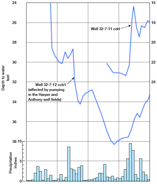
The recharge to and discharge from the ground-water reservoir can be shown by means of graphs of water levels in wells. Hydrographs of wells 32-7-11ccd and 32-7-12ccb1 and the monthly precipitation from 1954 through 1957 are shown in Figure 8. The water level in well 32-7-11cdd fluctuated in response to recharge from precipitation; the water level in well 32-7-12ccb1 fluctuated in response not only to recharge from precipitation, but also to a reduction of pumpage in the Harper and Anthony well fields.
Figure 8--Hydrographs of two wells in Harper County and monthly precipitation at Anthony.
Ground Water in Storage
The quantity of ground water in storage in the five ground-water areas in Harper County (Fig. 7) was determined by computing the volume of saturated material in these areas. This was computed by measuring the areas of equal saturated thickness shown in Plate 5 and multiplying the area by the thickness. A storage coefficient or specific yield of 15 percent was applied to the total volume of saturated material in each area to determine the quantity of water in storage. The quantity of water in storage in each area and the total quantity are given in Table 3.
Table 3--Quantity of water in storage in the Pleistocene deposits of Harper County.
| Ground-water area (Fig. 7) |
Quantity of water (acre-feet) |
|---|---|
| Upland | 365,000 |
| Big Sandy Creek | 140,000 |
| Bluff Creek | 137,000 |
| East Sand Creek | 104,000 |
| Chikaskia | 26,000 |
| Total | 772,000 |
Recovery
Principles of Recovery
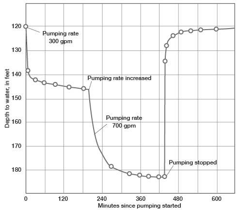
When water is pumped from a well, the water level in and around the well is lowered, the greatest lowering being in the well. This lowering of the water level is called drawdown, and the area in which drawdown occurs is called the cone of depression. The greater the pumping rate in a well, the greater the drawdown. A diagrammatic section of an aquifer showing the water level when a well is being pumped is shown in Figure 9. The shape of the cone of depression is determined by the ease with which water flows through the water-bearing formation. A well producing a given quantity of water from a very permeable aquifer will have less drawdown than a well drawing from less permeable material. Continued pumping gradually lowers the water level and causes the cone of depression to expand. If water is being withdrawn from storage in the aquifer, the water level will decline steadily, though at a decreasing rate as a greater volume of material contributes to the flow. (Fig. 10). If the pumping rate is increased, the rate of decline also will increase. When pumping is stopped, water continues to move toward the well until the water level returns to its original, or to a new, static level. The recovery of the water level is rapid at first but progressively slower as the static water level is approached.
Figure 9--Diagrammatic section of a well that is being pumped, showing its drawdown, cone of depression, and radius of influence.
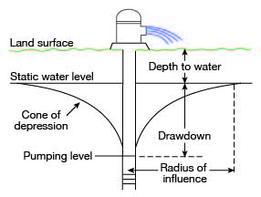
Figure 10--Drawdown and recovery of water level in pumped well.
Types of Wells
In any particular locality, the type of well to be constructed depends on several related factors. The most important factors controlling the type of well construction are the intended use of the water, the depth to the water, and the physical character of the water-bearing deposits. The relation of these factors to well construction is discussed below under the types of wells.
Dug wells--Dug wells are excavated with pick and shovel or with machinery. They generally are 2 to 5 feet in diameter, are relatively shallow, and are cased with stone, brick, or concrete. Generally the wells are dug only a few feet deeper than the depth to water. Dug wells are most common in Harper County where the Permian rocks are at or near the surface, as these rocks are generally poor aquifers and do not yield water readily; the dug well of large diameter provides storage capacity.
Driven wells--Driven wells are constructed in unconsolidated materials and consist of a small-diameter pipe, having a screen on the bottom, which is driven to a point a few feet below the water table. Driven wells can be constructed only where the water table is shallow, as the ability of pumps to lift the water is limited. Where the water table is deep a pit can be dug and the pump or cylinder can be installed in the pit so that the pumping lift will not be excessive. There are only a few driven wells in Harper County, and all of them are in unconsolidated materials in the valleys, where the water table is shallow.
Drilled wells--Drilled wells are constructed with percussion or rotary machines. The diameter and depth of drilled wells generally depend on the use to be made of the water from the wells, and partly on the depth to water. Domestic wells drilled in Harper County generally are 4 to 6 inches in diameter and penetrate the aquifer only far enough to supply the needed quantity of water. Municipal or irrigation wells are larger and generally penetrate the entire aquifer. Most drilled wells are cased with steel or galvanized pipe. In consolidated rocks the casing may be extended to a depth of only a few feet below the surface, but in unconsolidated rocks the casing, with a screen on the bottom, must be extended through these materials to keep the well from collapsing.
Utilization of Water
During the investigation in Harper County, data were obtained on wells, test holes were drilled, and drillers logs were collected and studied. The well data given in Table 10 pertain to 100 domestic and stock wells, 19 public supply wells, 8 industrial wells, 5 irrigation wells, 8 oil wells, and 2 observation wells.
Domestic and Stock Supplies
Most domestic and stock water supplies in Harper County are obtained from wells, although stock supplies in increasing number are obtained from artificial ponds. The ground water generally is suitable for domestic and stock use; however, it is excessively hard in much of the area underlain by Permian rocks. Locally in that area the water contains much sulfate or chloride and is therefore undesirable for domestic use. In much of the area underlain by Permian rocks the supply of water is not adequate for domestic or stock use during periods of prolonged drought, and much water must be hauled for domestic use. In most of the area underlain by rocks of Pleistocene age, the supply of water is adequate for domestic and stock use; however, where these deposits are thin, some wells go dry during periods of prolonged drought, and water must be hauled. An estimated 750 to 1,000 acre-feet of water is used annually for domestic and stock supplies in Harper County.
Public Water Supplies
Three cities in Harper County, Anthony, Attica, and Harper, have public water supplies. The water systems and wells in these communities are described below, and additional information is given in Table 10 and in the logs of wells and test holes.
Anthony--Anthony is the largest city in Harper County. Its first municipal water supply was built in 1885, but as this supply proved to be inadequate new wells were drilled in Bluff Creek Valley in sec. 33 and 34, T. 33 S., R. 7 W. Water was obtained from alluvium and Wisconsinan terrace deposits in a relatively narrow channel, and when there was water in Bluff Creek the supply from the wells was adequate. Nearly every year, however, Bluff Creek stopped flowing during the late summer and water was pumped from storage in the channel deposits. Pumping from storage quickly caused the water level in the wells to decline and the yields declined correspondingly. The water supply was operated in this manner until October 1954 when three new wells were drilled near Harper in sec. 12, T. 32 S., R. 7 W. The city of Anthony now has seven wells in the Bluff Creek area, only three of which are used. Water from these wells is used for cooling in the city's power-generating plant. The average daily pumpage from the Bluff Creek wells in 1956 was about 250,000 gallons.
The three new wells near Harper obtain water from deep channel deposits of Illinoisan and Wisconsinan age. The channel deposits in this area are relatively narrow, as indicated on geologic sections B-B' and E-E', Plate 2. The channel in section D-D' seems to be wider, but this geologic section parallels the axis of the deepest part of the channel and does not give a true representation of the width. The new Anthony supply wells are equipped with turbine pumps powered by electricity. The yield from each of the two west wells is about 500 gpm and from the east well about 300 gpm. The average daily pumpage from the three wells is about 750,000 gallons. The annual pumpage from the well field near Harper is about 800 acre-feet and from the Bluff Creek well field, about 250 acre-feet. The water is chlorinated at the wells but receives no other treatment. An elevated steel tank in the city provides storage of 50,000 gallons, and a steel tank near the well field near Harper provides storage of 100,000 gallons.
Attica--Prior to 1930 the public water supply for the city of Attica was obtained from shallow dug wells in the alluvium of Bluff Creek. These wells were not adequate, and in 1930 two wells were constructed in terrace deposits in a deep, narrow channel adjacent to Bluff Creek. These two wells are used as standby wells at present but the dug wells have been abandoned. Late in the thirties two additional wells were constructed; the combined yield of all four wells when pumped by airlift was about 120 gpm. These wells were drilled to a depth of about 130 feet; although there is only about 50 feet of terrace material, the additional depth was necessary to obtain sufficient submergence for pumping by airlift.
In 1943 a well was drilled in thin Pleistocene deposits west of the city, but it was abandoned because it yielded only about 15 gpm. In 1944 another well was drilled 200 feet east of the old well field. This well, which was equipped with a turbine pump, yielded about 40 gpm. About 170,000 gpd (gallons per day) was pumped from this field when Bluff Creek was flowing, but when the creek stopped flowing, water levels declined rapidly and the yield declined correspondingly.
In 1956 four additional wells were drilled about 6 miles north of the city. These wells obtain water from Pleistocene deposits of Kansan and Nebraskan age. All the wells are 8 inches in diameter, 90 feet deep, and equipped with submersible turbine pumps. Their combined yield is about 200 gpm. Storage is provided by a 50,000-gallon elevated steel tank. The water is chlorinated at the wells and receives no further treatment. The water from the old well field contained much sulfate and had a hardness of 322 ppm. Water from the new wells has a hardness of 142 ppm, all of which is carbonated hardness. The average daily pumpage to supply Attica is about 200,000 gallons; the annual pumpage is about 220 acre-feet.
Harper--The Harper water supply has been obtained from the same general area since 1907. The original supply was obtained from two wells drilled in a Pleistocene channel deposit of probable Illinoisan and Wisconsinan ages. One of these wells, about a mile west of the center of the city, is still in use. It is 54 feet deep and yields about 150 gpm. In 1940 the second of the original wells was abandoned and a new well (32-7-2dcb) was drilled in a deeper part of the channel. It is 80 feet deep and yields about 450 gpm. In 1954 another well was drilled in channel deposits about a mile south of the older wells. This well (32-7-11ad2) is 83 feet deep and yields 700 gpm. The water is chlorinated at the wells and receives no further treatment. Storage is provided by a 150,000-gallon elevated steel tank. The average daily pumpage is about 500,000 gallons, and the annual pumpage is about 550 acre-feet.
Industrial Supplies
Eight industrial wells, seven of which are being used, were canvassed during the investigation. Three wells, 31-8-5caa, 31-8-5ccc1, and 31-8-5ccc2, which yield 300, 150, and 120 gpm, supply water for the Magnolia Petroleum Co. extraction and compressor plant in northwest Harper County. They range in depth from 92 to 108 feet. The average daily pumpage is about 290,000 gallons, and the annual pumpage is about 325 acre-feet.
Phillips Petroleum Co. has one well (31-9-1ccc) that provides water for cooling at their compressor station about 2 miles west of the Magnolia Co. plant. This well is 102 feet deep, is equipped with a cylinder pump, and yields about 40 gpm. The average daily pumpage is about 50,000 gallons, and the annual pumpage is about 45 acre-feet.
Water for both the Magnolia Co. and Phillips Co. plants is obtained from Pleistocene deposits of Kansan and Nebraskan age in the Upland ground-water area (Fig. 7).
Cities Service Co. has three wells on the edge of the sand dunes in southwest Harper County, which provide water for cooling at a compressor plant. They are about 28 feet deep, are equipped with turbine pumps, and yield about 100 gpm each. The average daily pumpage from the three wells is about 80,000 gallons, and the annual pumpage is about 65 acre-feet. The water is obtained from Pleistocene deposits of Illinoisan and Wisconsinan age.
Irrigation Supplies
In the fall of 1956 only five irrigation wells were in operation in Harper County. One well was in the Upland ground-water area, three wells were in the East Sand Creek ground-water area, and one well was in the Big Sandy Creek ground-water area. (Fig. 7.)
Well 31-7-18bac, in the Upland area, is 83 feet deep, is equipped with a turbine pump, and yields about 300 gpm. It is used to irrigate about 80 acres of grain sorghums. The annual pumpage is about 100 acre-feet.
Three other irrigation wells, 32-6-4dcc, 32-6-9aac, and 32-7-12cda, are in the East Sand Creek area. Well 32-6-4dcc is 80 feet deep and yields 300 gpm. It is used to irrigate about 60 acres of feed crops, and the annual pumpage is about 100 acre-feet. Well 32-6-9aac is 67 feet deep and yields 560 gpm. The well is used to irrigate about 60 acres of feed crops, and the annual pumpage is about 80 acre-feet. Well 32-7-12cda, near the Anthony and Harper water-supply wells, is 100 feet deep, yields about 400 gpm, and is used to irrigate about 80 acres of wheat and maize. The annual pumpage is about 100 acre-feet.
Well 34-9-13cba, in the Big Sandy Creek area in southwestern Harper County, derives water from thin Pleistocene deposits. It consists of a battery of two wells 30 inches in diameter, 30 feet deep, and 20 feet apart. Both wells are connected to a single centrifugal pump driven by a natural-gas engine. The combined yield is about 400 gpm; the water is used to irrigate about 40 acres of alfalfa and 20 acres of maize. The annual pumpage is about 90 acre-feet.
Future development of irrigation supplies--Additional irrigation supplies could be developed in parts of Harper County, but not on a large scale. Wells having large yields probably cannot be developed in the county, but wells yielding as much as 500 gpm probably can be developed.
In much of the Upland area in northwest Harper County, irrigation wells yielding 300 to 500 gpm probably could be developed. The thickness of the saturated material (Pl. 2, Pl. 5) is sufficient for the development of small-capacity irrigation wells in most places, but the lithology changes greatly from place to place. Test holes should be drilled at proposed well sites to locate the greatest saturated thickness and the most permeable gravels.
The northern part of the Big Sandy Creek area contains considerable saturated material (Pl. 5). The gravels are very permeable locally, and a few properly situated wells could be developed to yield as much as 500 gpm each. The channels containing the thickest and most permeable deposits are narrow, and test drilling would be necessary to locate the best well sites. For most efficient operation, wells should be spaced far enough apart to avoid excessive drawdown due to mutual interference.
A few irrigation wells could be drilled in the East Sand Creek area also, but they should be properly spaced so as not to interfere with the Anthony and Harper water supplies. In this area also the channels are narrow, and the deposits seem to be less permeable than those in the Upland or Big Sandy Creek areas. Test drilling would be advisable to locate the thickest permeable material in this area.
Irrigation supplies in either the Chikaskia or Bluff Creek areas could be developed only locally, for in these areas the thickness of the saturated deposits (Pl. 5) generally is not sufficient for the operation of irrigation wells. Locally, as in the Anthony well field adjacent to Bluff Creek in sec. 34 and 35, T. 33 S., R. 7 W., the aquifer is thick enough for development of irrigation wells of low yield, but this area already is overdeveloped. Moreover, excessive drawdowns occur when the stream ceases to flow, which generally is the time when irrigation is most needed.
Prev Page--Geology || Next Page--Ground water--Aquifer Tests and Chemical character
Kansas Geological Survey, Geology
Placed on web Feb. 27, 2009; originally published March, 1960.
Comments to webadmin@kgs.ku.edu
The URL for this page is http://www.kgs.ku.edu/General/Geology/Harper/05_gw.html