![]()
Prev Page--Stratigraphy || Next Page--Pennsylvanian, Virgilian
Pennsylvanian System--Missourian Stage
Kansas City Group--Linn Subgroup
Chanute Shale
The upper part of the Chanute Shale (Haworth and Kirk, 1894, p. 109) is the oldest bedrock exposed in Franklin County, but its outcrop area is so small as to preclude mapping. Only one outcrop (SW SW SE sec. 27, T. 17 S., R. 21 E.) was found. Approximately the upper 10 feet of the formation is exposed on the outside of a meander along the Marais des Cygnes River. Moderate-brown silty shale, containing plant remains and a 0.1-foot coal streak, grades upward into medium-gray clayey shale.
Iola Limestone
The main area of Iola outcrops is in the vicinity of Lane (Pl. 1), and there only the upper part of the formation, an incomplete thickness of the Raytown Limestone Member, is exposed. Successively older Iola members, Muncie Creek Shale and Paola Limestone, apparently crop out at only one locality (SW 1/4 SW 1/4 SE 1/4 sec. 27, T. 17 S., R. 21 E.) A three-fold division of the Iola Limestone is recognized throughout the county in drillers logs.
Paola Limestone Member--In its only known exposure the Paola Limestone (Newell, in Moore, 1932, p. 92) is a light-gray, vertically jointed ledge devoid of shale breaks or partings and about 2.5 feet thick. The uniformly microcrystalline matrix contains randomly distributed fossils, including brachiopod, crinoid, and algae remains. Irregular tubules filled with argillaceous limestone occur in the uppermost 0.2 to 0.3 foot of the unit and may represent worm borings. Surfaces of the member are relatively even and contacts with adjacent shale are relatively sharp.
Muncie Creek Shale Member--The Muncie Creek Shale (Newell, in Moore, 1932, p. 92), as seen in only one exposure, is light-olive-green silty shale. No black fissile shale occurs but phosphatic nodules are present. Commonly the Muncie Creek is chiefly black fissile shale and is recorded as such in some of the drillers logs. The thickness of the member is about 0.5 foot.
Raytown Limestone Member--The Raytown Limestone (Hinds and Greene, 1915, p. 27) is the upper member of the Iola Limestone. The best exposure of the Raytown in Franklin County is along a small tributary to Pottawatomie Creek, and a section measured there is given below.
| Measured section of the Iola Limestone in NW SE SW sec. 34. T. 18 S., R. 21 E. | Thickness (feet) |
||
|---|---|---|---|
| Lane Shale (not exposed) | |||
| Iola Limestone | |||
| Raytown Limestone Member | |||
| Limestone, light gray, thin to thick bedded and wavy bedded, shale paintings along bedding surfaces, fine grained, compact; Punctospirifer, productid brachiopods, fenestrate bryozoans, horn corals, crinoid columnals, echinoid spines; member contacts concealed; thickness exposed | 9.5 | ||
| Muncie Creek Shale Member (not exposed) | |||
The thickness of individual beds ranges from 2 inches to 2 feet but is rarely more than 6 inches. Relief on bedding planes of about 0.2 foot in a lateral distance of 1 foot is common and, in general, thicker parts of a bed are vertically contiguous with thinner parts of adjoining beds. Discontinuous shale partings separate some of the beds. Shell fragments in the fine-grained matrix weather into relief and are visible in cross section on fresh surfaces of the limestone. Since both lower arid upper contacts of the unit are concealed, complete thickness of the member was not measured. Drillers logs indicate a thickness range of 8 to 11 feet in the subsurface.
Kansas City Group--Zarah Subgroup
Lane Shale
The Lane Shale (Haworth, 1895, p. 277) is exposed near the town of Lane in the southeast part of the county. The type exposure (S2 sec. 33, T. 18 S., R. 21 E.) is covered by vegetation and colluvium, but about the upper two-thirds of the formation is well exposed 1 1/2 miles south of Lane. The basal 5 to 10 feet of the Lane is not exposed.
The Lane Shale consists of gray, green, and red shale and claystone, tan siltstone, and tan sandstone. Shale in the upper half of the formation is silty and micaceous and locally includes beds of red shale and claystone not more than 2 feet thick. Locally, sandstone beds form the middle part of the Lane. Lepidodendron, Calamites, and unidentified remains of other land plants are sparsely distributed in the silty shale and the siltstone in the upper half; sparse brachiopod and pelecypod casts are found in the clayey to silty shale in the lower half of the Lane. The upper two-thirds of the formation has been eroded into steep slopes broken by ledges of more resistant siltstone; the lower third forms a gradual slope down to the Raytown Limestone escarpment and is concealed by vegetation. Sections measured on the outcrop and subsurface data indicate that the Lane Shale is about 60 feet thick.
Wyandotte Limestone
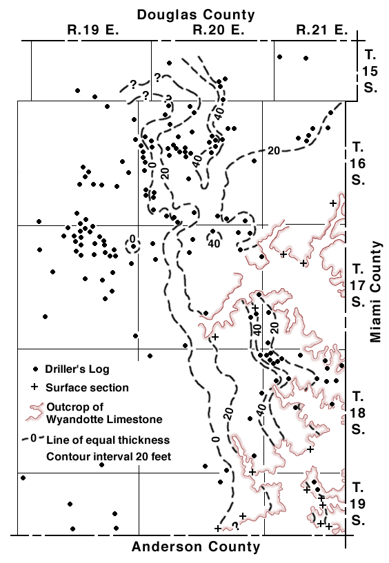
The Wyandotte Limestone is best exposed in bluffs near Marais des Cygnes River and Pottawatomie Creek in the eastern part of the county. As shown in Figure 2, it pinches out in the subsurface near the north-south center line of Franklin County.
Figure 2--Thickness map of the Wyandotte Limestone in eastern Franklin County.
In Kansas the formation comprises five members, in ascending order: Frisbie Limestone, Quindaro Shale, Argentine Limestone, Island Creek Shale, and Farley Limestone. In Franklin County the Quindaro Shale is absent in all outcrops studied and is not indicated in available drillers logs. A section measured where the entire formation is exposed is given below.
| Measured section of the Wyandotte Limestone in NE SE sec. 9, T. 19 S., R. 21 E. | Thickness (feet) |
||
|---|---|---|---|
| Plattsburg Limestone | |||
| Bonner Springs Shale | 0.3 | ||
| Wyandotte Limestone | |||
| Farley Limestone Member | |||
| Limestone, bight gray, thin to thick bedded and irregularly to relatively even bedded, microcrystalline; Osagia-oolith layer in central part of upper 3 feet; Composita, Enteletes, Neospirifer, bryozoan fragments; about | 5.0 | ||
| Island Creek Shale Member | |||
| Limestone-limonite conglomerate; brachiopod, bryozoan, and crinoid remains; about | 2.0 | ||
| Argentine Limestone Member | |||
| Limestone, light gray to brown on fresh surfaces, weathers tan, thin to thick bedded and wavy bedded, fine grained, compact; algae, abundant Enteletes, productid brachiopods, bryozoans, crinoids; about | 33.0 | ||
| Frisbie Limestone Member | |||
| Limestone, chocolate brown on both fresh and weathered surfaces, dense, single vertically jointed bed devoid of shale breaks or partings, fractures to massive blocks, breaks conchoidally; Enteletes, productid brachiopod fragments, Lophophyllidium, robust fusulinids, sparse crinoid remains | 3.5 | ||
| Total thickness of Wyandotte Limestone | 43.5 | ||
| Lane Shale | |||
Frisbie Limestone Member--The Frisbie Limestone (Newell, in Moore, 1932, p. 92) is the lowermost member of the Wyandotte Limestone. The Frisbie is well exposed in only a few places. Bedding characteristics and, in some exposures, color differences, both of which are modified by weathering, facilitate differentiation of the Frisbie from the overlying Argentine Limestone. Drillers logs of holes in eastern Franklin County also show a continuous limestone section from the top of the Argentine to the base of the Wyandotte Limestone, as at the surface. Until core data are available, little knowledge can be gained of the subsurface distribution of the Frisbie in Franklin County.
This rock is uniformly brown and dense and is a single, massive, vertically jointed bed devoid of shale partings. Where well exposed, the Frisbie weathers into a sharp-cornered ledge, overhanging the steep slope of the underlying Lane Shale. Close examination, however, shows that the contact between the two rocks is relatively gradational through a thickness of 0.1 to 0.2 foot. The upper contact of the Frisbie (with the Argentine) is sharp. Fossils include algae, Enteletes, productid brachiopods, lophophyllid corals, and robust fusulinids. Because of the denseness of the Frisbie Limestone, the fracture is smooth and conchoidal. In cross sections, fusulinids and other shells appear to dot the fine-grained matrix. The obesity and the abundance of fusulinids in the Frisbie contrasts sharply with the slender, rodlike form and paucity of fusulinids in the Argentine. The thickness of the Frisbie ranges from 0 to 6 feet and averages 4 feet.
Argentine Limestone Member--The Argentine Limestone (Newell, in Moore, 1932, p. 92) is the most persistent member of the Wyandotte Limestone. It crops out in all exposures of the Wyandotte, except in the immediate vicinity of NW corner sec. 13, T. 19 S., R. 20 E., but is best exposed in bluffs and quarries near Lane and in bluffs bordering the Marais des Cygnes River floodplain in the eastern part of the county.
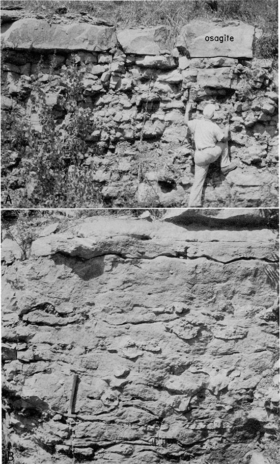
This light-gray limestone weathers into thin to thick wavy beds 2 inches to 2 feet thick, but the thickness of individual beds rarely exceeds 8 inches. The uppermost bed is massive and algal in many exposures (e.g. Pl. 3A). In some places elliptical chert nodules 2 to 12 inches in long dimension and 2 to 8 inches in short dimension (Pl. 3B) are distributed randomly in the upper 15 feet of the unit. Silicified invertebrate fossils are enclosed in the chert nodules. On fresh surfaces of the rock the uniformly fine-grained matrix is interrupted by acicular stringers of coarsely crystalline calcite 1 to 4 inches long. Differential etching of the matrix imparts a distinctive relief to weathered surfaces of the Argentine. The fossil assemblage consists of algae (including an Osagia coating on shell fragments in the upper massive bed), Enteletes, Composita, productid brachiopods, bryozoans, crinoids, and sparse, slender, rodlike fusulinids. The abundance of Enteletes, especially in the southeast part of the county, distinguishes the Argentine faunally from all other limestone in Franklin County. The thickness of the member ranges from approximately 15 to 34 feet except in T. 19 S., R. 20 E., where the Argentine is very thin.
Plate 3--Road cut exposure (section A2) in SE corner sec. 8, T. 17 S., R. 21 E. A, Massive osagite in the upper part of the Argentine Limestone Member of the Wyandotte Limestone. B, Chert nodules in the Argentine Limestone.
Abrupt thinning and facies change in the Argentine in T. 19 S., R. 20 E., and southwestward are striking. A traverse of exposures southwestward from Lane (see Pl. 2, sections A13, A15, and A7) shows a thinning from 34 to 0 feet in a distance of about 4 miles. At section Al5, midway between A13 and A7 and approximately 2 miles from each, the Frisbie and Argentine Limestones crop out in a prominent escarpment. At that place the Frisbie is 6 feet thick, and 12 feet of the overlying Argentine is exposed below a soil mantle. Nowhere in its outcrop area is more than 3 feet of the Argentine weathered to soil; therefore, complete thickness of the Argentine here was probably about 15 feet. An almost uniform rate of thinning of 8 feet to the mile between sections A13 and the immediate vicinity of A7 is thus indicated. Limy siltstone and impure limestone at sections A8, A9, and Al0 (Pl. 2) occupy the stratigraphic position of the Wyandotte and, on the basis of their fossil assemblages, are regarded as Argentine.
Island Creek Shale Member--The Island Creek Shale (Newell, in Moore, 1932, p. 92) is identified only in the vicinity of Lane (Pl. 2, sections A6 and A12-A14), and even here only tentatively. Recognition is possible only where the overlying discontinuous Farley Limestone is present. Where Farley is absent, all strata between the Argentine and the Merriam Limestones are assigned to the Bonner Springs Shale.
The Island Creek Shale includes tan silty shale and tan quartzose sandstone between the Argentine Limestone and the Farley Limestone. At section A6, a sandstone bed 1 to 2 feet thick crops out 5 feet below the top of the Island Creek, which there is 14 feet thick. A fossiliferous limonitic limestone conglomerate, about 2 feet thick, in sections A12 and A13 is classed as Island Creek. Except for fossils in this conglomerate, the Island Creek is apparently non-fossiliferous in Franklin County.
Farley Limestone Member--The uppermost member of Wyandotte Limestone is the Farley Limestone (Hinds and Greene, 1915, p. 29). Classification of strata as Farley Limestone in Franklin County is based wholly on the fact that these beds have about the same stratigraphic position (i.e., in the lower part of a predominantly shale section between Argentine and Merriam Limestones) as the type Parley in Platte County, Missouri. Outcrops of Farley Limestone are restricted to a small area, in which four exposures were found (Pl. 2, sections A6 and Al2-A14).
Light-gray and brown, detrital, cross-stratified limestone beds that have an aggregate thickness of about 7 feet are assigned to the Parley at section A6. Ooliths, foraminifers (including sparse fusulinids), crinoid debris, and predominantly sand-size shell fragments coated with Osagia are firmly cemented by microspar calcite. Sparse nautiloid cephalopods weather into relief in the lower part of the unit. In other exposures, the Parley Limestone is about 5 feet thick and is lithologically similar to the Argentine--color, bedding, textural details, and general fossil assemblage are nearly identical--but an abundance of Neospirifer and the absence of Enteletes differentiate the strata from the Argentine.
Bonner Springs Shale
Clean exposures of the Bonner Springs Shale (Newell, in Moore, 1932, p. 93) are scarce. It is well exposed just east of Middle Creek bridge on the road west from Rantoul (NW NE sec. 26, T. 17 S., R. 20 E.). Thickness ranges from a featheredge to approximately 45 feet. Where it is less than 20 feet thick, the Bonner Springs is predominantly gray-green silty shale. Where the thickness of the formation exceeds 20 feet, the lower half consists of interlayered tan and gray-green silty shale, tan siltstone, and tan quartzose sandstone. Individual siltstone and sandstone beds are not more than 2 feet thick. The upper half of the formation, described in ascending order, consists of tan clayey and silty shale, red shale 1 to 2 feet thick, a yellow-tan claystone bed 1 foot thick, and tan silty to clayey calcareous shale. In Miami, Johnson, Wyandotte, and Leavenworth Counties (Newell, 1935, p. 67; Jewett and Newell, 1935, p. 179), as in Franklin County, the claystone, which weathers to a distinctive boxwork, and the red shale are useful markers. One or both of these units characterize the upper 10 feet of the formation in most surface exposures and are recorded on many drillers logs.
Sparse remains of land plants in the silty shale and sparse gastropods in the claystone bed probably are in place. Minute fossil debris, sparsely distributed throughout the shale in exposures south of the town of Lane, where the formation is less than 1 foot thick (e.g., section A 12), probably are not indigenous to the Bonner Springs.
Lansing Group
Plattsburg Limestone
The Plattsburg Limestone comprises the Merriam Limestone, Hickory Creek Shale, and Spring Hill Limestone Members, which were named by N.D. Newell (in Moore, 1932, p. 93). The three members are continuous at the surface and probably in the subsurface. However, the formation is recorded on most drillers logs as a uniform limestone section. Salient characteristics of the Plattsburg are summarized in the two measured sections given below.
| Measured section of the Plattsburg Limestone exposed in a road cut near the cen. S line sec. 29, T. 16 S., R. 21 E. | Thickness (feet) |
||
|---|---|---|---|
| Vilas Shale (not exposed) | |||
| Plattsburg Limestone | |||
| Spring Hill Limestone Member | |||
| Limestone, bight gray on both fresh and weathered surfaces, weathers into thin to thick irregular beds, microcrystalline, compact; Composita, productid brachiopods, crinoid fragments; thickness exposed | 6.0 | ||
| Hickory Creek Shale Member | |||
| Shale, tan, calcareous, and limestone, tan; limestone stringers oriented parallel to bedding in shale; limestone weathers to a rubble of fragments predominantly 0.1 to 0.5 foot in bong dimension and 0.1 foot in short dimension; sparse crinoid fragments | 0.4-1.5 | ||
| Merriam Limestone Member | |||
| Limestone, gray on fresh surfaces, weathers tan, weathered surface pitted or "worm eaten", a single bed; brachiopods, crinoids; upper contact within gradational rubble zone of overlying member | 0.5 | ||
| Limestone, gray on fresh surfaces, weathers tan, a single massive bed, vertically minted; prominent Composita-myalinid zone in lower half; basal contact within underlying rubble zone | 0.9 | ||
| Limestone, tan on both fresh and weathered surfaces, impure, shaly; grades into underlying shale | 0.3 | ||
| Total thickness of Merriam Limestone | 1.7 | ||
| Bonner Springs Shale | |||
| Measured Section of the Plattsburg Limestone exposed in a road cut near the cen. S line sec. 27, T. 16 S., R. 21 E. | Thickness (feet) |
||
|---|---|---|---|
| Vilas Shale (not exposed) | |||
| Plattsburg Limestone | |||
| Spring Hill Limestone Member | |||
| Limestone, light gray on both fresh and weathered surfaces, weathers into thin wavy beds; microcrystalline matrix interrupted by randomly oriented coarsely crystalline calcite stringers; brachiopod, bryozoan, and crinoid remains; thickness exposed | 6.0 | ||
| Hickory Creek Shale Member | |||
| Shale, yellow brown, calcareous, and limestone, tan, 0.1- to 0.2-foot stringers intercalated with shale | 2.3 | ||
| Merriam Limestone Member | |||
| Limestone, gray, weathered surface pitted or "worm eaten", a single bed; microcrystalline matrix contains scattered brachiopod and crinoid remains | 0.5 | ||
| Limestone, gray, weathers tan, thin cross-stratified bedding, Osagia-oolite texture; foraminifers, clams, brachiopods; coarse fraction cemented by coarsely crystalline calcite | 7.0 | ||
| Limestone, gray, a single massive bed, vertically jointed, fine grained, compact; prominent Composita-myalinid zone in lower half; upper surface is an erosion surface; basal Contact gradational through 0.2 foot | 1.5 | ||
| Total thickness of Merriam Limestone | 9.0 | ||
| Bonner Springs Shale | |||
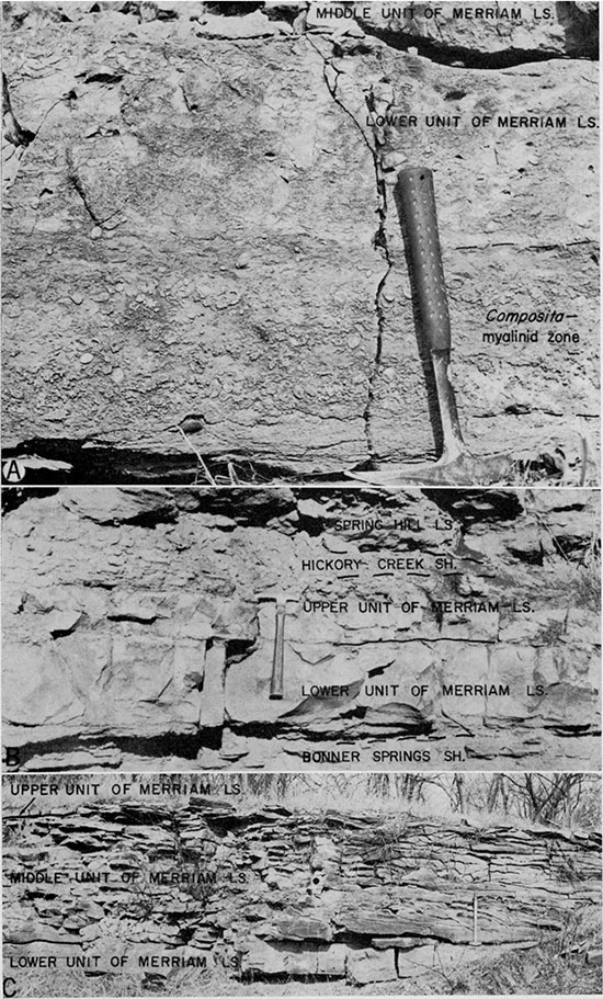
Plate 4--Typical Plattsburg Limestone, described in measured sections above. A, Composita-myalinid zone in lower unit of Merriam Limestone Member at center south line sec. 27, T. 16 S., R. 21 E. B, Pitted or "worm-eaten" surface of upper unit of Merriam Limestone at center south line sec. 29, T. 16 S., R. 21 E. C, Cross-stratified middle unit of Merriam Limestone, same locality as A. Dot indicates position of sample shown in Plate 5A.
Merriam Limestone Member--Where it has been studied, the Merriam Limestone weathers into a prominent ledge. A uniform gray and, in some cases, a bluish-gray color is common on fresh surfaces. The four units which commonly compose the Merriam are, in ascending order: (1) basal impure limestone, 0.3 foot or less thick; (2) a compact lower limestone unit, 0.7 to 1.5 feet thick; (3) an upper limestone unit, 0.4 to 0.7 foot thick; and (4) a topmost impure limestone crust, 0.3 foot or less thick.
The basal and topmost units are absent in some exposures. Distinctive characteristics of the member are a Composita-myalinid zone in the compact lower limestone unit, and the pitted or "worm-eaten" surface of the upper limestone unit (Fig. 3 and Pl. 4). Upper and lower contacts of the Merriam are commonly within gradational zones of impure limestone and calcareous shale.
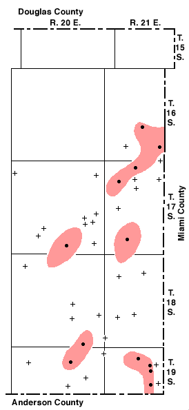
An additional limestone unit is present in some Merriam exposures. Stratigraphic relationships and inferred distribution of this unit (referred to as the middle unit) are shown in Figures 3 and 4. The middle unit is a number of cross-stratified limestone lentils, which crop out in narrow, sinuous belts as much as 6 miles long and 2 miles wide (Fig. 4). Maximum thickness of the lentils is 6 feet. Sets of cross strata are as much as 3 feet thick, and the cross strata range from paper-thin to about 1 foot in thickness and measure as much as 20 feet in length (Pl. 4C). The cross strata are composed of predominantly sand-size ooliths, foraminifers, and shell fragments, some of which are coated with algae, moderately to tightly packed and cemented by coarsely crystalline calcite (Pl. 5A). Mollusk fragments larger than sand size are common (Pl. 5B). The texture and sedimentary structures of the middle Merriam indicate that it was heaped together by currents powerful or persistent enough to winnow away any microcrystalline ooze that otherwise might have accumulated as a matrix, and that the interstitial pores were filled by directly precipitated calcite cement.
Plate 5--Middle unit of Merriam Limestone Member of Plattsburg Limestone. A, Negative print of thin section (X5) of sample collected at center south line sec. 27, T. 16 S., R. 21 E. (see Pl. 4C). B, Peel print of osagite texture (X6.5) of sample collected from section A6, near center south line sec. 35, T. 18 S., R. 20 E. Vertical surfaces, orientation as shown.
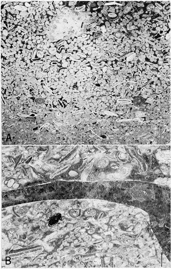
Figure 3--Sequence, thickness, and lithology of units forming the Merriam Limestone Member in Franklin County.
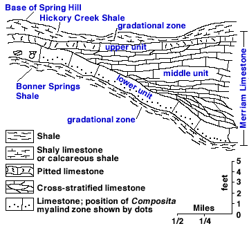
Figure 4--Map of eastern Franklin County showing approximate area (shaded) in which the middle unit of the Merriam Limestone Member is present. Outcrop control.
| Locations of sections used in Figure 4 | |||||||||||||||||||||||||||||||||||||||||||||||||||||||||||||||||||||||||||||||||||||||||||||||||||||||||||||||||||||||||||||||||||||||||||||||||||||||||||||||||||||||||||||||||||||
|---|---|---|---|---|---|---|---|---|---|---|---|---|---|---|---|---|---|---|---|---|---|---|---|---|---|---|---|---|---|---|---|---|---|---|---|---|---|---|---|---|---|---|---|---|---|---|---|---|---|---|---|---|---|---|---|---|---|---|---|---|---|---|---|---|---|---|---|---|---|---|---|---|---|---|---|---|---|---|---|---|---|---|---|---|---|---|---|---|---|---|---|---|---|---|---|---|---|---|---|---|---|---|---|---|---|---|---|---|---|---|---|---|---|---|---|---|---|---|---|---|---|---|---|---|---|---|---|---|---|---|---|---|---|---|---|---|---|---|---|---|---|---|---|---|---|---|---|---|---|---|---|---|---|---|---|---|---|---|---|---|---|---|---|---|---|---|---|---|---|---|---|---|---|---|---|---|---|---|---|---|---|
middle Merriam present |
middle Merriam absent |
||||||||||||||||||||||||||||||||||||||||||||||||||||||||||||||||||||||||||||||||||||||||||||||||||||||||||||||||||||||||||||||||||||||||||||||||||||||||||||||||||||||||||||||||||||
|
|
||||||||||||||||||||||||||||||||||||||||||||||||||||||||||||||||||||||||||||||||||||||||||||||||||||||||||||||||||||||||||||||||||||||||||||||||||||||||||||||||||||||||||||||||||||
Hickory Creek Shale Member--The Hickory Creek Shale is named for Hickory Creek in eastern Franklin County. Exposures along Hickory Creek are concealed by vegetation, slump material, and colluvium. The section described on page 13 (center south line, sec. 29, T. 16 S., R. 21 E.) is typical of this member in Franklin County.
The Hickory Creek Shale has a maximum thickness of 6 feet (Pl. 2, A12), but it is less than 1.5 feet thick in most exposures studied. Its lithology is characteristically ochery shaly limestone or calcareous shale and is gradational with the underlying Merriam Limestone and the overlying Spring Hill Limestone.
Spring Hill Limestone Member--The Spring Hill Limestone, which is persistent west of its outcrop in Franklin County, comprises two limestones and an intervening shale; only the lower limestone, which has an aggregate thickness of 11 to 16 feet, is present in most exposures. Fossils and other aspects of lithology allow ready separation of the lower or principal limestone of the Spring Hill into three units. The lowermost unit ranges from 6 to 7 feet in thickness and consists of evenly to slightly irregularly bedded, fine-grained, gray limestone. Individual beds are 0.2 to 1 foot thick. Enteletes, productid brachiopods, and bryozoans are the common faunal elements. The middle unit ranges from 2 to 4 feet in thickness and its strata are from 0.5 to 1 foot thick. A foraminiferal osagite and an overlying 2- to 6-inch concentration of robust Composita form the gray limestone of the middle unit. This Composita zone (Fig. 5 and Pl. 6A) is a widespread and useful marker throughout the county. Newell (1935, p. 72) noted a persistent oolite bed in southern Johnson County in that part of the Spring Hill herein designated the middle unit; however, no oolite was observed in the Spring Hill in Franklin County. The upper unit is darker gray than the middle and lower units and measures 3 to 5 feet thick. The lower 2 to 4 feet of the upper unit consists of fusulinids, algae, echinoid spines, and brachiopod remains in a microcrystalline calcite matrix. The uppermost foot of the upper unit contains a prolific clam and bryozoan faunule. Myalina, Fistulipora, and Meekoporella, in order of abundance, are the predominant genera (Fig. 5 and Pl. 6B). Clam valves are arranged parallel to the bedding and are embedded in quartzose silt cemented with calcite.
Plate 6--Spring Hill Limestone Member of Plattsburg Limestone. A, Composita zone at top of middle unit of Spring Hill. Bedding surface of limestone block on quarry floor in SE SE sec. 27, T. 16 S., R. 20 E. B, Peel print (X2.6) of clam concentration at top of upper unit (section B3). Vertical surface, orientation as shown. Sample collected in quarry near center east line SE sec. 6, T. 18 S., R. 20 E.
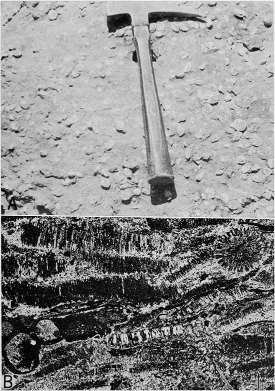
Figure 5--Composite sequence of lithologies forming the Spring Hill Limestone Member in Franklin County.
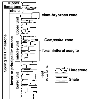
Overlying the lower or principal limestone of the Spring Hill, a shale and a limestone, each approximately 1 foot thick, crop out below the Vilas Shale in the SE sec. 6, T. 18 S., R. 20 E., and are recorded on several drillers logs. The shale is gray blue, clayey, and calcareous; the limestone is gray blue to gray brown and fossiliferous. These units (Fig. 5) are included in the Spring Hill because they crop out at the type locality of the member (Newell, 1935, p. 102) and because of practicality in mapping, but they are not observed in most Kansas outcrops of the Spring Hill.
In the southeasternmost part of Franklin County, southeast of Pottawatomie Creek, the lower part of the principal limestone of the Spring Hill is mantled with chert. Silicified forms of the fossils characteristic of the Spring Hill throughout the county, especially Girtyocoelia, are included in the chert pebbles, cobbles, and boulders. The chert is angular and poorly sorted, showing no indication of stream transportation. Obviously the chert originated in situ by replacement of the Spring Hill. In the exposures studied, the chert mantle ranges from about 2 to 6 feet in thickness and immediately overlies incomplete thicknesses of the Spring Hill Limestone. Interpolation between exposures of the Spring Hill north of Lane in Franklin County (maximum thickness 18 feet) and exposures north of Garnett in Anderson County (average thickness about 25 feet) indicates a probable thickness of about 22 feet of Spring Hill Limestone in southeastern Franklin County prior to chertification. This chert residuum is restricted to the uplands, does not extend into the subsurface, and is not a remnant of an alluvial terrace.
Vilas Shale
The Vilas Shale (Adams, 1898, p. 96), the middle formation of the Lansing Group, is continuous throughout Franklin County west of its outcrop. Few characteristics of the Vilas Shale and of shale next older and younger than the Lansing Group can be regarded as diagnostic. Identification of the Vilas is aided by its position in sequence between the escarpment-forming Plattsburg and Stanton Limestones, by its intermediate percentage of silt as compared to the next older and siltier shale formation (Bonner Springs) and the next younger and less silty shale formation (Weston), and by its general lack of fauna.
Blue-gray, green, and gray-brown shale laminae, which weather into flakes, characterize the Vilas. Where the laminae are extremely thin, the bedding is indistinct and the formation weathers into blocks of irregular size and shape as much as 3 inches long. The thickness of the Vilas Shale is quite variable (from approximately 1 to 23 feet) and shows no directional trends that can be related to its geographic distribution.
Stanton Limestone
The Stanton Limestone is the uppermost formation of the Lansing Group. The Stanton is continuous in the subsurface in Franklin County. Members of the formation are, in ascending order: Captain Creek Limestone, Eudora Shale, Stoner Limestone, Rock Lake Shale, and South Bend Limestone, which locally is absent in the subsurface. A stratigraphic section typical for Franklin County is given below.
| Measured section of the Stanton Limestone exposed in an abandoned quarry in the SE sec. 27, T. 16 S., R. 20 E. (Captain Creek Limestone and Eudora Shale) and in the NW cor. sec. 22, T. 16 S., R. 20 E. (Stoner Limestone, Rock Lake Shale, and South Bend Limestone). | Thickness (feet) |
||
|---|---|---|---|
| Weston Shale (not exposed) | |||
| Stanton Limestone | |||
| South Bend Limestone Member | |||
| Limestone, gray blue mottled brown on fresh surfaces, weathers tan, thin to thick bedded and even bedded, extremely dense, fractures conchoidally; Dielasma, Derbyia, Meekella, Neospirifer, distinctive Chonetes crust atop lowest bed, fusulinids, crinoid and bryozoan fragments; thickness exposed | 3.2 | ||
| Rock Lake Shale Member | |||
| Shale, gray green, clayey to silty, weathers into flakes | 0.3 | ||
| Coal stringer | 0.1 | ||
| Shale, gray green, weathers into irregular blocks | 1.0 | ||
| Limestone, gray on both fresh and weathered surfaces, nodular, silty | 1.0 | ||
| Limestone, blue gray, finely brecciated; pleurotomariid gastropods; thickness variable | 1.8 | ||
| Total thickness of Rock Lake Shale | 4.2 | ||
| (Disconformity) | |||
| Stoner Limestone Member | |||
| Limestone, gray to white on both fresh and weathered surfaces, thin to thick bedded and slightly wavy bedded, upper surface hummocky; Composita, Derbyia, Punctospirifer, algal remains, crinoid columnals and calyx plates, echinoid spines, euomphalid gastropods | 19.0 | ||
| Eudora Shale Member | |||
| Shale, gray green, clayey to slightly silty, weathers into flakes; sparse crinoid fragments | 4.5 | ||
| Shale, black, clayey to silty, weathers platy or into fissile laminae; conodonts | 4.3 | ||
| Shale, gray green, clayey; paper-thin strata weather to flakes | 1.5 | ||
| Total thickness of Eudora Shale | 10.3 | ||
| Captain Creek Limestone Member | |||
| Limestone, light gray to tan, thin bedding extremely even in lower half, wavy in upper half, microcrystalline; Enteletes, crinoid columnals, echinoid spines, abundant Ottonosia in upper 3 feet | 7.2 | ||
| Vilas Shale | |||
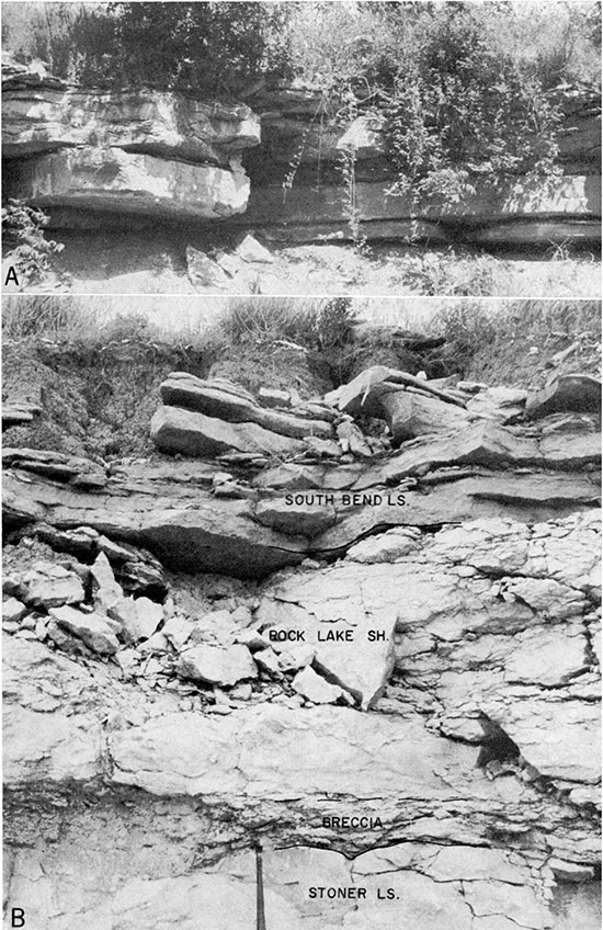
Plate 7--Quarry exposures of Stanton Limestone. A, Even-bedded Captain Creek Limestone Member (section B7), SE SE sec. 27, T. 16 S., R. 20 E. B, Disconformable contact between Stoner Limetone Member and Rock Lake Shale Member (section B1), center east line sec. 23, T. 18 S., R. 19 E.
Captain Creek Limestone Member--The Captain Creek Limestone (Newell, 1935, p. 76) is continuous both at the surface outcrop and in the subsurface in Franklin County, and it is uniform lithologically in all exposures studied. On the basis of fossil content and gross lithology the Captain Creek can be divided into two units, which persist across the county. The lower unit ranges from blue gray to brown and weathers into extremely even beds (Pl. 7A) from 0.3 to 1 foot thick, which have a maximum aggregate thickness of approximately 3 feet. Its texture is compact and it contains fossil debris embedded in microcrystalline calcite. Algae, sparse foraminifers (including fusulinids), crinoid fragments, fenestrate bryozoans, lophophyllid corals, Enteletes, and other brachiopods are present. The rock is hard and brittle and breaks with conchoidal fracture.
In the upper unit a mottling in shades of blue, gray, and brown is characteristic. Franklin County quarrymen call this mottled unit the "Calico Rock". It is compact, brittle, slightly irregularly bedded, and sparingly fossiliferous. Largely algal, it also contains brachiopod and echinoid remains. Individual beds range from about 0.3 to 0.7 foot in thickness and the aggregate thickness averages about 5 feet. The contact of the upper unit with the overlying Eudora Shale is gradational in some exposures and sharp in others. Where the black fissile part of the Eudora is in contact with the Captain Creek Limestone, blue parts of the mottled Captain Creek are abnormally dark, almost black.
Eudora Shale Member--The Eudora Shale (Condra, 1930, p. 12) is continuous west of its outcrop in Franklin County and is the oldest black fissile shale exposed in the county. The black shale of the Eudora is slightly silty but is predominantly clayey shale. In most exposures the black shale is contiguous with the underlying Captain Creek Limestone, but elsewhere the two are separated by 1.5 feet or less of gray-green shale that weathers into flakes. In all sections studied 4.5 feet or less of gray-green clayey shale separates the black fissile part, which ranges from 1.5 to 4.5 feet thick, and the overlying Stoner Limestone. Locally the upper gray-green shale is abundantly fossiliferous. The average thickness of the entire member is about 7 feet.
Carbonate-phosphate nodules and concretions formed around fossils or small aggregates of pyrite are found in the black shale, which also contains low-spired gastropods, some pyritized; Lingula and Orbiculoidea; the conodonts Hindeodella, Lochodina, and Ozarkodina; pyritized pectinoid clams; sparse articulate brachiopods; Conularia; and sparse carbonized land plants.
Stoner Limestone Member--The Stoner Limestone (Condra, 1930, p. 11) has a relatively large number of surface exposures because it is extensively quarried. Drillers logs indicate that the Stoner is continuous in the subsurface in Franklin County.
Light-gray fine-grained limestone, which weathers into thin to thick irregular beds, forms the Stoner. Individual beds range from about 3 inches to 2 feet in thickness and have an aggregate thickness of about 18 feet. Fossils of a number of phyla are represented, but individuals in any one phylum are not abundant. Algae, pygidia of the trilobite Ameura, productid and other brachiopods, crinoid stem fragments and calyx plates, echinoid spines, fenestrate bryozoans, foraminifers (including fusulinids), and gastropods are common in the Stoner.
At localities B1 and B8 (Pl. 2) breccia in the lowermost foot of the overlying Rock Lake Shale and marked relief of 1 to 3 feet on the upper surface of the Stoner indicate disconformity. Where the breccia is developed, the Stoner-Rock Lake contact is gradational (Pl. 7B) because of reworking. Disconformity at the top of Stoner Limestone, within the Rock Lake Shale, or at the base of South Bend Limestone is apparent in most exposures of these strata between Leavenworth County and central Wilson County, Kansas.
Rock Lake Shale Member--Surface study of the Rock Lake Shale (Condra, 1927, p. 59) in Franklin County is limited almost entirely to quarry and road-cut exposures, since natural exposures are covered by colluvium and residual soil. Except for possible local absence, the Rock Lake is continuous in the subsurface of western Franklin County.
Variable lithology is the most noteworthy characteristic of the Rock Lake Shale. Near Ottawa the Rock Lake contains sandstone, limestone, and shale (NW 1/4 SW 1/4 sec. 5, T. 17 S., R. 20 E., Concrete Materials Quarry, and NW 1/4 SW 1/4 sec. 12, T. 17 S., R. 19 E., Fogle's Quarry). In both exposures the lower 0.2 to 1.5 feet is a limestone breccia or "mortar" bed composed of minute limestone fragments and fossil gastropods in a shaly limestone matrix. Overlying the breccia is 0.5 foot or less of arenaceous limestone or limy sandstone that is discontinuous along the quarry faces. Additional units form parts of the Rock Lake in the Concrete Materials Quarry but are absent in Fogle's Quarry. These additional units are a 2.6-foot shaly limestone, which contains mollusks and brachiopods, and an overlying 1-foot brachiopod-bearing calcareous shale.
A quarry section measured near Princeton includes the Rock Lake Shale. There the succession is: a 0.5- to 1-foot breccia that grades upward into approximately 4 feet of shaly limestone, which is overlain by 0.7 foot of gray-green non-fossiliferous clayey shale. In all exposures studied the thickness of the member is variable, ranging from 0.2 to 5.4 feet.
South Bend Limestone Member--The South Bend Limestone (Condra and Bengston, 1915, p. 23) is the uppermost member of the Stanton Limestone. Drillers logs indicate that the member is absent locally in the subsurface. Complete thicknesses of the South Bend are exposed only in quarries and road cuts.
The South Bend Limestone is gray blue and brown banded on fresh surfaces, and it weathers brown. Color, an extremely dense texture in the upper part, even bedding, and an arenaceous lower part distinguish the South Bend from limestone within the underlying Rock Lake Shale. Individual beds range from 0.3 to 1.4 feet in thickness, are thinner in the lower half than in the upper half of the member, and have an average aggregate thickness of about 4 feet. Meekella striatocostata and abundant Chonetes are common in the upper part of the South Bend but were not found elsewhere in Franklin County. Fusulinids are locally abundant, as are crinoids, echinoids, and bryozoans.
Pedee Group
Weston Shale
The Pedee Group includes the Weston Shale (Keyes, 1899, p. 300) below and the Iatan Limestone (Keyes, 1899, p. 300) above. Because no Iatan Limestone is recognized in Franklin County and because the Weston Shale commonly grades upward into the Stranger Formation, the upper contact of the Pedee is represented by a dashed line in most places on the geologic map (Pl. 1).
The Weston Shale is gray blue, clayey, and relatively free of silt. Locally (e.g., sec. 23, T. 17 S., R. 19 E.) it contains well-preserved plant remains in the middle and upper parts. Discontinuous layers of ironstone concretions are found in the upper one-third of the Weston, and locally upper parts of the formation are tan and silty. Lentils of fossiliferous limestone conglomerate crop out in a zone approximately 15 feet below the top of the Weston at the center west line SW sec. 14, T. 17 S., R. 19 E. (A columnar section measured at this locality and the stratigraphic classification applied to rocks exposed there are shown in Figure 6.) This zone of limestone-shell "hash" conglomerate lentils in silty shale (Fig. 6, lithology 3), considered by Bowsher and Jewett (1943, p. 30-31) to be the proper contact between the Weston Shale and Tonganoxie Sandstone, was not observed elsewhere in Franklin County. In this report the contact between the Weston and the Tonganoxie is placed at the base of a silt-stone-sandstone or a coal, whichever is lowermost in local exposures.
A complete thickness of the Weston Shale could not be measured accurately along the outcrop. Data from drillers logs, test drilling, and surface measurements indicate a thickness range of about 45 to 110 feet. The average thickness of the formation is about 60 feet.
Prev Page--Stratigraphy || Next Page--Pennsylvanian, Virgilian
Kansas Geological Survey, Geology of Franklin County
Web version July 2002. Original publication date Jun. 1963.
Comments to webadmin@kgs.ku.edu
The URL for this page is http://www.kgs.ku.edu/General/Geology/Franklin/03_strat2.html