KGS Home

Geology Index Page

Jefferson County

Geologic Maps of Kansas   Zoom Out
small map of Kansas; click to change counties

Jefferson County geologic map

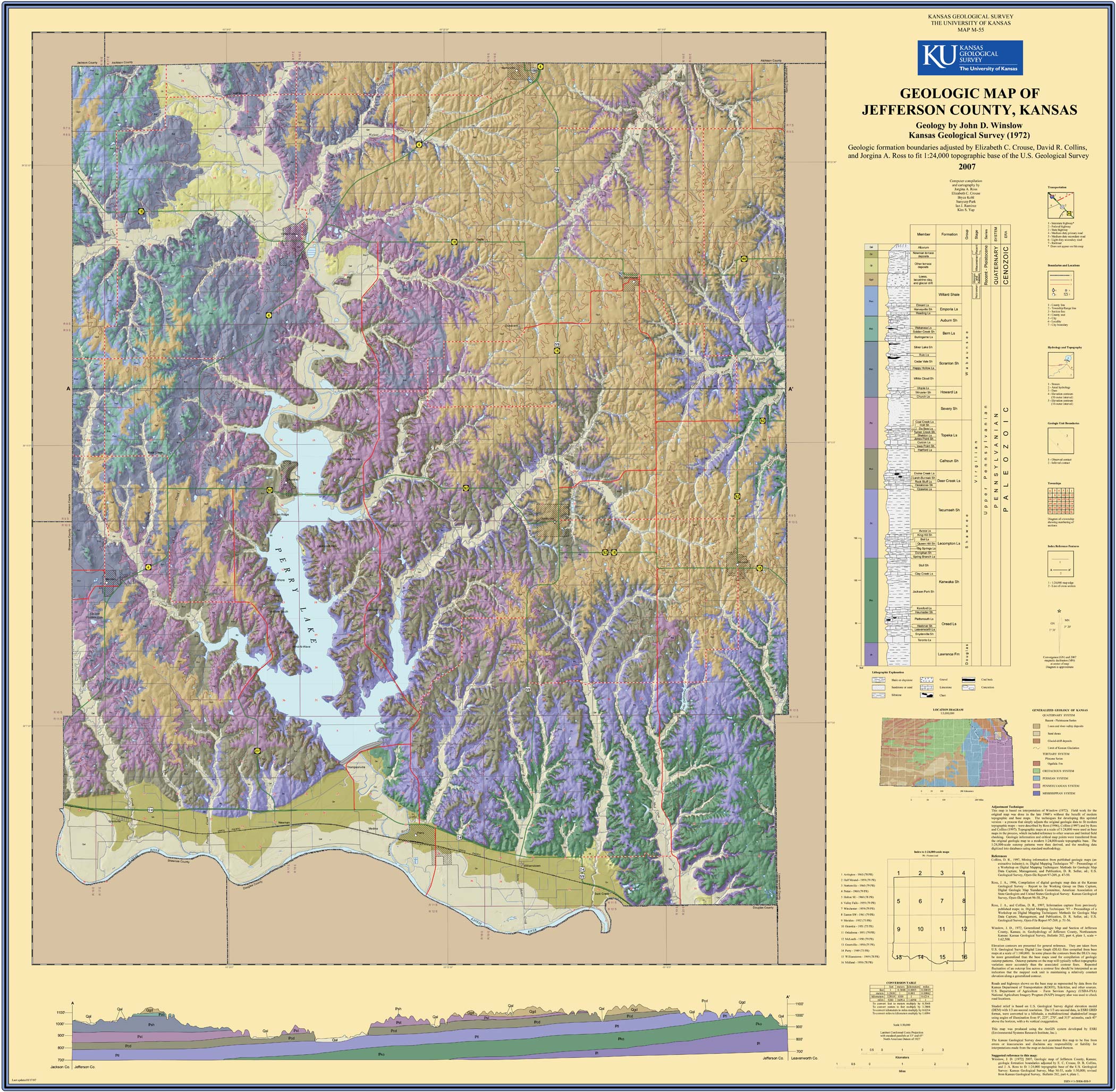
Winslow, J.D., [1972] 2007, Geologic Map of Jefferson County, Kansas; geologic formation boundaries adjusted by E.C. Crouse, D.R. Collins, and J.A. Ross to fit 1:24:000 topographic base of the U.S. Geological Survey: Kansas Geological Survey, Map M-55, 1 sheet, scale 1:50,000.
Paper copies of the complete map (with stratigraphic column and legend info) can be purchased from the Kansas Geological Survey, 1930 Constant Ave., Lawrence, KS 66047 (or phone 785-864-3965) and at 4150 W. Monroe St., Wichita, KS 67209-2640 (phone 316-943-2343).

Winslow, J.D., 1972, Geohydrology of Jefferson County, northeastern Kansas: Kansas Geological Survey, Bulletin 202(4), 20 p. (available online)

Cheyenne Sherman Wallace Greeley Hamilton Stanton Morton Rawlins Thomas Logan Wichita Kearny Grant Stevens Scott Finney Finney Haskell Seward Decatur Sheridan Gove Lane Gray Meade Norton Graham Trego Ness Hodgeman Ford Clark Phillips Rooks Ellis Rush Pawnee Pawnee Edwards Edwards Kiowa Comanche Smith Osborne Russell Barton Stafford Stafford Pratt Barber Barber Jewell Mitchell Lincoln Ellsworth Rice Reno Kingman Harper Republic Cloud Ottawa Saline McPherson Harvey Sedgwick Sedgwick Sumner Washington Clay Dickinson Marion Marion Butler Cowley Riley Riley Riley Geary Geary Morris Chase Marshall Pottawatomie Pottawatomie Wabaunsee Wabaunsee Wabaunsee Lyon Lyon Greenwood Greenwood Elk Chautauqua Nemaha Jackson Jackson Shawnee Shawnee Osage Coffey Woodson Wilson Montgomery Brown Atchison Jefferson Jefferson Douglas Douglas Franklin Anderson Allen Neosho Labette Doniphan Leavenworth Leavenworth Wyandotte Johnson Johnson Miami Linn Bourbon Crawford Cherokee no info

Cartographic Services, Kansas Geological Survey
Updated Oct. 25, 2007
Comments to webadmin@kgs.ku.edu
URL=http://www.kgs.ku.edu/General/Geology/County/ghj/jefferson.html