Kansas Geological Survey, Open-File Rept. 93-1
Annual Report, FY92--Page 20 of 20
The primary objective of the FY92 database work was the development of an interface between ARC/INFO, the geographic information system (GIS) used at the KGS, and the ground-water flow model MODFLOW. Instead of recreating work that had already been completed by someone else, we chose to modify an existing interface that was primarily designed and written by Peter Van Metre of the Austin, Texas, Field Unit of the U.S. Geological Survey.
The incorporation of ARC/INFO with the MODFLOW groundwater model in the interface is intended to facilitate movement of the Dakota aquifer databases from the GIS to the flow model and subsequently to return the output to a form that allows for easy postprocessing. Therefore the GIS acts as both a preprocessor and a postprocessor. Output can be in tabular data sets or maps, either of which can be created relatively quickly. The characteristic of the interface that is probably most valuable is the automation of many aspects of the modeling process. The GIS allows for interpolation of values for grid nodes that can be completed much faster than could be done by hand. This aspect becomes especially important when modeling a system as large and complex as the Dakota aquifer. It also allows for interactive editing of parameters at the nodes in the model cells, either visually by plotting the grid on the screen or in the relational database of ARC/INFO. As mentioned previously, the GIS also makes it convenient for creating map products of both input data and output results. The interface itself does not transform or manipulate the data and is used only for the storage and movement of the data into and out of the GIS.
The interface developed by Van Metre was designed for a Prime computer system and was primarily based on the Control Program Language, INFO programs, and Fortran programs operating on the Prime. Most of the interface needed conversion before use on the KGS computer system. Four major guidelines made this interface attractive:
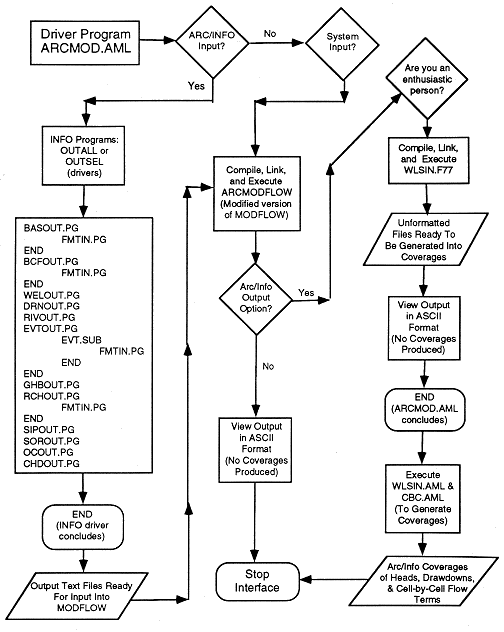
There are essentially five steps to the flow of the interface program. The program (1) enters INFO, determines which packages are in use, and determines the parameters required for the model run, (2) runs the INFO package output program using the control files containing the parameters and outputs system files for the model run, (3) executes MODFLOW, which opens and uses the system files that were output in the previous step, and (4) executes a FORTRAN program that opens selected output files and reformats the records for input back into INFO. At this point the user can view the output files to determine whether the results are reasonable. If the results are unacceptable, the user can then take advantage of the interactive capabilities of the GIS to correct controls or values being fed into the system and then reexecute the interface and model. If, however, the results appear to be satisfactory, the user can execute one or both of the final programs to produce GIS coverages, which can then be used to produce map output. The last step of the interface program is (5) execution of one of two programs that allow the user to produce GIS coverages of either hydraulic heads and drawdowns or flow terms.
Figure 57 shows a simplified flow chart of the processes and options of the interface. The interface allows input of data in several forms, including the GIS databases and the original file format that MODFLOW was originally designed to handle. Output can either consist of ARC/INFO databases in the form of coverages or the original MODFLOW output file in an ASCII format.
Figure 57--Simplified flow chart of the MODFLOW- ARC/INFO interface. This chart is intended to show an overview of the processes and options available.
To test the interface from start to finish, we set up a simple hypothetical example including a small grid and sample data set. The results showed that the interface performed properly for data handling. The next step is to test the program using a large data set with actual values for the Dakota aquifer. The grid is for the regional flow model and covers a large portion of central and western Kansas and a small part of southeast Colorado.
The KGS provided information on the hydrogeology and water quality of the Dakota aquifer to Hays as a part of the city's search for additional supplies of ground water for municipal use. An additional part of this information included cooperating with the Kansas Corporation Commission and the city of Hays during the drilling of the test wells in the Dakota aquifer to determine the source of saline water found in the ground water. In another cooperative project with a state agency, the Kansas Water Office sampled the Smoky Hill, Saline, and South Fork Solomon rivers, and the KGS determined saltwater sources of saline river waters that receive discharge from Cretaceous strata.
The KGS organized a symposium at the University of Kansas to present research accomplishments and plans of the Dakota aquifer program to many state and local agencies, university and industry staff, and the public. The symposium provided a useful forum for communication of results and receipt of needs and suggestions for proposed work. Other information transfer concerning the program included answering questions and providing data in response to many requests for information on the Dakota aquifer from a wide variety of individuals.
The primary emphases during the latter part of the FY92-95 period are (1) to integrate the geologic, geohydrologic, and geochemical results from previous research to form conceptual models of the aquifer system and useful products for water-resource evaluation and (2) to develop three-dimensional digital models of the Dakota and adjacent aquifers in southeastern Colorado and southwestern and central Kansas that can be used to simulate the flow of water, transport of solutes, and chemical reactions along the flow path. These simulations will be useful for testing hypotheses about the nature of the flow system in the Dakota aquifer, for determining rates of interchange between aquifers, and for assessing the effects of pumping on water availability and quality. Development and the use of the quasi-three-dimensional models to simulate the hydrology are being carried out in phases. Phase 1 work is reported in this FY92 report and includes determination of the factors controlling the ground-water flow system (such as the arrangement of aquifer and aquitard units), the effect of topography, and a conceptual water budget that estimates the amount of recharge to and discharge from the aquifer along a cross section from southeastern Colorado to central Kansas. Work on the regional and subregional steady-state simulations of the Dakota aquifer will continue through FY93. In the latter part of FY94 work will begin on developing a transient-flow model that will be completed in FY95 for southwestern Kansas to allow simulation of the effect of pumping. The transient-flow, regional steady-state flow, and coupled flow and chemical models will be used to assess the effect of various water-management options in FY95.
Late in FY94 research will also shift to the deeper subsurface of west- central, northwest, and north-central Kansas. In these areas readily available data are sparse, the depth to the top of the Dakota aquifer is considerable, and salinities are commonly high. The main focus will be on the areas adjacent to the region under present development and areas that are predicted to have usable water quality. The area comprises Greeley, Wichita, Scott, Lane, Wallace, Logan, Gove, and parts of Hamilton, Kearny, Sheridan, and Graham counties in west-central Kansas as indicated in Figure 3 of this report. A map of TDS concentration produced during the Dakota program predicts that the ground waters are fresh (less than 1,000 mg/l TDS) in approximately 46% and between 1,000 and 2,000 mg/l TDS in 37% of this area. A monitoring site is being planned for the Dakota aquifer in northeast Gove County to assess the potential for new supplies of water in the subregion. Some preliminary sampling in a few wells will be conducted in FY93 in the southern portion of this area as part of the cooperative project with the Lawrence Livermore National Laboratory. Additional work will be conducted in FY94-95 for northwestern Kansas, and in Jewell, Smith, and Phillips counties in northern Kansas where the water quality is generally poor because of high TDS concentrations.