Kansas Geological Survey, Open-File Rept. 93-1
Annual Report, FY92--Page 4 of 20
The U.S. Geological Survey completed the drilling of the pumping-test well and one observation well in the Cheyenne Sandstone in the lower part of the Dakota aquifer and one deeper observation well in the Permian Morrison formation. The wells are located in SESESW SE sec. 21, T. 29 S., R. 43 W., in southwest Stanton County, about 3 mi (5 km) north-northeast of Saunders. The location is in the valley of Bear Creek and several hundred feet to the east of the creek. The three wells have been assigned well identification numbers 372024102012001 through 372024102012003 in the USGS GWSI (Ground- Water Site Inventory) database. The observation wells are located 12 ft (3.7 m) and 30 ft (9.1 m) from the pumping-test well in a general east-west orientation.
The pumping-test well (372024102012001) was installed at a finished depth of 280 ft (85.3 m) after the hole was backfilled with bentonite from the drilled total depth of 582 ft (177 m). The well has a 5-in. (13-cm) diameter PVC casing and 40 ft (12 m) of 0.020-in. (0.5 mm) mill-cut slotted PVC screen and is filter-packed with medium sand from 294 ft to 235 ft (89.6-71.6 m). The annular space above the filter pack is sealed with a mixture of polymer gel and bentonite up to 80 ft (24 m) depth and with bentonite up to the land surface.
The deeper observation well (372024102012002) in the Morrison formation was installed at a finished depth of 415 ft (126 m) after the hole was backfilled from the drilled depth of 422 ft (129 m). The observation well is a 2-in. (5-cm) diameter PVC-cased well with 20 ft (6.1 m) of 0.020-in. (0.5-mm) mill-cut slotted PVC screen and is filter-packed with medium sand from 422 ft to 382 ft (124-116 m). The annular space above the filter pack is sealed with a grout mixture of polymer gel and bentonite up to 120 ft and with bentonite up to the land surface.
The second observation well (372024102012003) in the lower Dakota aquifer was installed at a finished depth of 270 ft (82.3 m) after the hole was backfilled from the drilled depth of 282 ft (86.0 m). The observation well is a 2-in. (5-cm) diameter PVC-cased well with 20 ft (6.1 m) of 0.020-in. (0.5-mm) mill-cut slotted PVC screen and is filter packed with medium sand from 282 ft to 242 ft (86.0-73.8 m). The annular space above the filter pack is sealed with a grout mixture of polymer gel and bentonite up to within a few feet of the land surface and with bentonite up to the land surface.
Slug and Pumping Tests Conducted at the Finney and Hodgeman County Monitoring Sites
In FY92 the KGS continued a program of well testing directed at gathering more information about the storage and transmissive properties of the Dakota aquifer system in central and southwestern Kansas. Field testing was completed at two sites in Hodgeman and Finney counties in late FY92. Testing at the remaining site in Stanton County will be completed by early FY93. Analysis of all the test results will be included in the FY93 report.
The field testing program at both sites lasted about one month. The general procedure was to begin monitoring at a site 10 days to 2 weeks before a planned pumping test. Ground- water levels were monitored with electronic pressure transducers, and atmospheric pressure was monitored with an electronic barometer. Both the transducers and the barometer were connected to a data logger so that data could be recorded without the need for human intervention. Before placement at the site, the transducers and barometer were calibrated at the KGS.
This initial period of monitoring was designed to gather information about background water levels at the site and to help define the relationship between barometric pressure variations and water-level fluctuations. An understanding of the relationship between barometric pressure and water levels is necessary to correct the drawdown data measured during the pumping test for any changes in atmospheric pressure that might occur during the test.
A series of slug tests was performed at each site before the pumping test. These slug tests allowed some preliminary estimates of the subsurface flow properties at the site to be determined. These preliminary estimates were then used to plan the mechanics of the pumping test. Without the information from the slug tests, it would be difficult to estimate a pumping rate that would produce measurable drawdown at the observation wells but not be great enough to cause water levels at the pumping well to fall beneath the intake screen of the pump.
After a 10-day to 2-week period of background monitoring, a pumping test lasting approximately 24 hours was performed at each site. During this test, the well was pumped at a constant rate and drawdown was measured in both the pumping and observation wells. In addition to the transducers and the barometer, an electronic flowmeter was employed to closely monitor the rate of pumping throughout the test. As with the other equipment, the flowmeter was calibrated at the KGS before use in the field. Note that manual readings of water levels using an electric tape and flow rate measurement using a calibrated bucket were taken frequently during the test to supplement the electronically gathered data.
A final 10-day to 2-week period of monitoring followed the pumping test. The purpose of this monitoring was to assess the recovery of water levels after the period of pumping and to gather further information about the relationship between water-level fluctuations and atmospheric pressure changes. At the end of this period a final series of slug tests was performed to assess how the 24 hours of pumping had changed the estimates of flow properties obtained from the earlier slug tests.
The program of slug tests carried out at each site was based on methods recently developed at the KGS. The slug tests were performed using the KGS packer-based slug test system (Butler et al., 1990). In this system an inflatable rubber packer is lowered into the well on 3/8-in. pump rods. The packer is placed below the static water level in the well but above the well screen. It is then inflated from the surface using nitrogen gas, closing off the annular space between the inner diameter of the well and the original outer diameter of the uninflated rubber packer. The central pipe on which the packer is mounted is the only connection between the screened and cased portions of the well. This pipe can be opened and closed using a brass plug that is attached to the pump rods. A slug test is initiated by closing off the central pipe and adding water above the packer. This slug of water is then instantaneously introduced into the well screen by opening the central pipe. The water- level response to the introduced slug is measured with a pressure transducer placed above the packer.
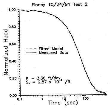
After completion of a slug test, the data are analyzed with SUPRPUMP, an automated well-test analysis package that was recently developed at the KGS (Bohling and McElwee, 1992; Bohling et al., 1990), to obtain estimates of the transmissivity and storativity of the formation in the vicinity of the well. Figure 13 displays the results of such an analysis for a Dakota well at the Hodgeman County test site, and Figure 14 displays the results of such an analysis for a Dakota well at the Finney County site. Note that at both sites multiwell slug tests (McElwee et al., 1991) were also attempted. As described in the FY91 report (Macfarlane et al., 1992), the multiwell slug test can provide parameter estimates of much greater reliability than conventional single-well slug tests. Unfortunately, because of the nature of the well construction at the Hodgeman and Finney County sites, the multiwell slug tests met with only limited success.
Figure 13--Data and fitted model results for a slug test performed in the Dakota observation well at the Hodgeman County site.
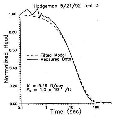
Figure 14--Data and fitted model results for a slug test performed in the Dakota pumping well at the Finney County site.
Cooperative Monitoring Site in Gray County with Southwestern
Kansas
Groundwater Management District No. 3
Concerns about the degree of hydraulic connection between the Dakota and the overlying High Plains aquifer in southwestern Kansas Groundwater Management District No. 3 (GMD3) are being addressed in a cooperative project between the GMD3 and the Kansas Geological Survey. Monitoring well sites are being established that consist of two wells, one screened in the Dakota aquifer and the other in the High Plains aquifer. It is anticipated that the monitoring sites will be used for short-term hydrologic testing and monitoring conducted by the KGS and longer-term monitoring by the GMD3.
The first monitoring site was established in Gray County (SESENE sec. 26, T. 27 S, R. 28 W.) in FY92. Wells were drilled and constructed by Don Fulton with the assistance and guidance of Alan Wade of the Kansas Geological Survey during March 5-12, 1992. Each well is a standpipe piezometer cased with 2-in. (5-cm) diameter PVC. The KGS developed the wells during March 25-26, 1992, by pumping 1,700 gal (6,435 l) from well 1 and 2,200 gal (8,329 l) from well 2; samples were collected at the end of each well development. The samples were taken to the KGS laboratories for analysis. Well construction and water-level information are listed in Table 1.
The Gray County monitoring site is located at the Gray County Feeders stockyard, near Montezuma, Kansas, near an erosional re-entrant in the Upper Cretaceous aquitard. The total thickness of the Ogallala Formation and Pleistocene deposits at the site is approximately 260 ft (79 m). However, the saturated thickness is only about 70 ft (21 m). The High Plains aquifer monitoring well is approximately 230 ft deep and is screened near the bottom of the aquifer in a silty sand and gravel. The upper Dakota aquifer is separated from the overlying Ogallala by approximately 140 ft (43 m) of Greenhorn Limestone and Graneros Shale, which constitutes the Upper Cretaceous aquitard at this site. The upper Dakota monitoring well is approximately 475 ft (145 m) deep and is screened in a sandstone of probable deltaic origin in the upper part of the D sandstone, Dakota Formation. At this site the difference in water levels between the Dakota and the overlying High Plains is approximately 33 ft (10 m), indicating a significant tendency for downward flow between aquifers under natural conditions.
Table 1--Well-Construction Information and Water Levels during Period of Development of the Gray County Monitoring Well. Well construction values are depths below land surface. Water levels are depths below the top of the casing, which is 1.9 ft above the well pad.
| Well | Aquifer | Screened interval (ft) |
Gravel-pack interval (ft) |
Water level before development 3-25-92 (ft) |
Water level after development 3-26-92 (ft) |
|---|---|---|---|---|---|
| 2 | Ogallala | 210-230 | 200-232 | 185.9 | 185.7 |
| 1 | Dakota | 455-475 | 439-500 | 219.0 | 220.3 |
The quality of the water samples collected from both wells is fresh (Table 2). Comparison of the water chemistry for the two wells suggests that some recharge from the Ogallala Formation may be entering the underlying Dakota aquifer. Water is fresh in the Dakota aquifer all along the flow path from the west through Stanton, Grant, and Haskell counties to the Gray County monitoring site. Thus it is difficult to estimate the amount of recharge from the overlying Ogallala relative to the recharge from the west that combines in the Dakota at this location. Although the chloride concentrations are low and nearly the same in the two aquifers, the sulfate concentration is substantially higher in the Dakota. The higher sulfate content might be from oxidation of pyrite (iron sulfide) in finer-grained sediments in the Dakota system. The lower calcium and higher sodium concentrations in the Dakota compared with the Ogallala suggest that cation exchange may have altered the water chemistry in the Dakota aquifer. Recharge from the Ogallala containing higher calcium concentration could be the main drive for the ion exchange. The lower calcium content in the Dakota water has allowed calcium minerals containing fluoride to dissolve, producing a higher fluoride content. (See also the section on the hydrogeochemistry of fluoride in this report.) The greater nitrate concentration in the Ogallala, although well below the drinking water standard, is most probably from an agricultural source, such as the stockyard area.
Table 2--Dissolved Constituent Concentrations in Water Samples Collected from the Gray County Monitoring Wells on March 26, 1992 after Well Development. Sp.C. and TDS refer to specific conductance in microsiemen/cm (microS/cm) and total dissolved solids (in mg/L), respectively. All other concentrations are in mg/L. The total dissolved solids was calculated from the sum of the constituents after converting bicarbonate (HCO3) to evaporated carbonate and assuming silica (SiO2) concentrations of 15 and 20 mg/L for wells 1 and 2, respectively, based on data for other Dakota and Ogallala well waters.
| Well and aquifer | Sp.C. (microsiemen/cm) |
TDS | Ca | Mg | Na | K | Sr | HCO3 | SO4 | Cl | F | NO3-N |
|---|---|---|---|---|---|---|---|---|---|---|---|---|
| 2-Ogallala | 425 | 264 | 59.8 | 8.6 | 18.6 | 3.7 | 0.47 | 218 | 19.5 | 7.1 | 0.45 | 4.2 |
| 1-Dakota | 450 | 283 | 39.8 | 8.3 | 47.4 | 3.8 | 0.59 | 205 | 53.9 | 8.0 | 1.06 | 1.0 |
In the near future the owners of the stockyard plan to drill and construct at least one high-capacity production well in the upper Dakota. This will provide an opportunity to monitor changes in the flow system and the water chemistry in both aquifers during development. It is anticipated that KGS will be working closely with the GMD3 to gather the necessary hydrologic and geochemical data to document these changes through time. A second monitoring site has been discussed with the GMD3 for southern Haskell County but has not been scheduled.