Kansas Geological Survey, Open-File Rept. 93-1
Annual Report, FY92--Page 2 of 20
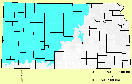
Figure 1--Extent of the Dakota aquifer in Kansas.
Program Overview
In recognition of the need for an integrated program of research, the KGS has
been carrying out and coordinating an eight-year-long multi-agency program to
assess the water-resources potential of the Dakota aquifer since FY89. The program
is conducted as integrated interdisciplinary research incorporating aspects of
hydrology, structural geology, sequence stratigraphy, borehole and surface
geophysics, geochemistry, and well engineering. The overall objectives of the
Dakota aquifer program (FY90-94) are (1) to characterize subregionally the
water-resources potential of the areas where the Dakota aquifer is shallowest and
is undergoing development in central and southwestern Kansas in FY90-91 and (2)
to develop conceptual models of ground-water flow and assess water-planning and
regulatory scenarios (FY92-94). The areas of investigation during the program are
shown in Figure 2.
Figure 2--Subareas of investigation in the Dakota aquifer program.
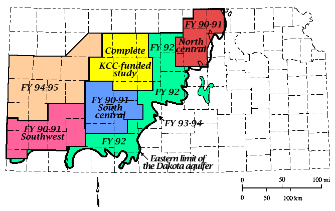
Work completed in the first three years of the program is described in the FY89,
FY90, and FY91 annual reports and in additional reports on specific portions of
the work and is displayed in maps. In FY92 research was conducted in areas not
covered by the previous years in selected portions of the previous subareas for more
detailed studies and across selected subareas to examine regional characteristics of
the Dakota aquifer system. In addition, work has been directed toward further
definition of the long-term research plans for the Dakota aquifer program.
Description and Use of the Aquifer
The Dakota and related aquifer systems are widely distributed geographically, covering
much of the midcontinent of North America. The Dakota aquifer underlies most of the
western two-thirds of Kansas and nearly all of Nebraska and eastern Colorado. Although
the Dakota aquifer in Kansas is nearly as extensive as the High Plains aquifer (Ogallala
Formation and associated alluvial deposits), generally lower well yields and greater depths
across most of the aquifer and lower water quality in many areas have limited its use.
However, good quality and well yields in large areas of the Dakota aquifer system have
resulted in use for irrigation, public water supply, and industry in southwestern and central
Kansas and southeastern Colorado.
The Dakota aquifer has been used for water supply in Kansas and southeastern Colorado for nearly a century. In Kansas approximately 96% of the total volume of ground water withdrawn from the Dakota is from the southwestern and south-central parts of the state where irrigation wells pump from the Dakota alone or from wells screened in both the Dakota and High Plains aquifers. However, irrigation use also occurs in the outcrop areas of the Dakota in central and north-central Kansas. What limited data exist suggest that long-term declines in water levels are greatest in southeastern Colorado and southwestern Kansas where flowing wells were once common in the Arkansas River. A figure showing the areas of artesian flow mapped for the Dakota aquifer in 1904 is included in the FY91 annual report (Macfarlane et al., 1992).
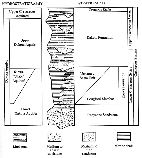
The Dakota aquifer system consists of interbedded lenses of sandstone and mudstones of Cretaceous age. The Dakota aquifer consists of three geologic formations: the Dakota Formation (the most important part of the aquifer relative to water use), the Kiowa Formation, and the Cheyenne Sandstone (Figure 3). The hydrostratigraphic classification developed for the Dakota aquifer divides the aquifer into the upper Dakota aquifer (the Dakota Formation), the lower Dakota aquifer (the sandy Longford Member of the Kiowa Formation and the Cheyenne Sandstone), and the Kiowa "Shale" aquitard (the shaly portion of the Kiowa Formation that restricts flow between the upper and lower Dakota aquifer).
The Dakota is a near-surface aquifer in southeastern Colorado and parts of southwestern and central Kansas. In most of southwestern Kansas and southeastern Colorado the aquifer underlies and is hydraulically connected to the overlying High Plains aquifer. Most of the Dakota aquifer in Kansas is overlain by younger shales, chalks, and limestones of Cretaceous age that form the upper Cretaceous aquitard that confines the aquifer (Figure 3). The Graneros Shale is the rock unit in the aquitard that immediately overlies the Dakota aquifer.
Figure 3--Stratigraphic and hydrostratigraphic classification of units that compose the Dakota aquifer in Kansas.
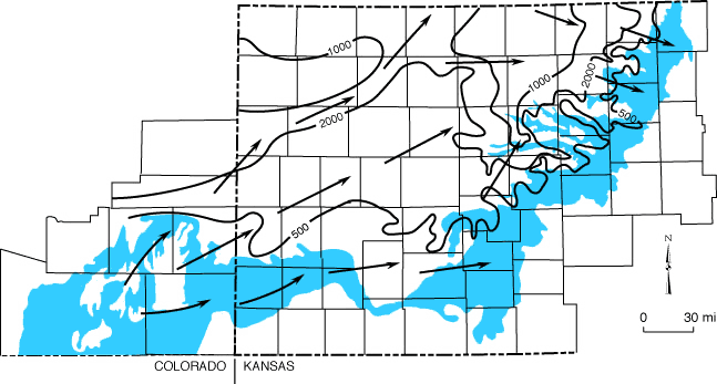
Rainfall recharge enters the Dakota aquifer in the outcrop areas in southeastern Colorado and southeastern and central Kansas. Freshwater also recharges the aquifer from the overlying High Plains aquifer in southeastern Colorado and southwestern Kansas. The main pattern of regional ground-water flow in the Dakota aquifer is from the recharge areas in southeastern Colorado and southwestern Kansas to discharge areas in the river valleys of central and north-central Kansas (Figure 4). Where freshwater recharge enters the Dakota, the water quality is good. However, recharge from underlying Permian rock units, especially the Cedar Hills Sandstone in central Kansas, has increased the salinity of the aquifer waters in large areas of the aquifer covered by the upper Cretaceous aquitard.
Figure 4--Direction of ground-water flow in the Dakota aquifer. Recharge enters the aquifer in southeastern Colorado and southwestern Kansas and then leaves the aquifer in central Kansas.
FY92 Activities and Results
Results presented in this annual report provide important advances in the
understanding of the distribution of aquifer units, the ground-water flow system, and the
water quality of the Dakota aquifer system. Research activities initiated earlier in the
program continued, and new projects were started on the geologic framework,
geohydrology, and geochemistry of the aquifer areas currently being developed. Although
the focus of many of the diverse projects was on southwestern Kansas, other projects were
conducted in central and north-central Kansas.
The FY92 activities in the program area involving the geologic framework of the Dakota aquifer were (1) geologic mapping in southwestern Kansas, (2) analysis of geophysical logs for producing geologic cross-section images and monitoring site characterization, and (3) geostatistical analysis of sandstone and shale distributions. The geologic mapping focused on southwestern Kansas and was based on interpretation of information from geophysical logs. A colored image for a geologic cross section from southwestern to central Kansas was generated using computer analysis of geophysical logs to better illustrate aquifer unit characteristics. The geostatistical research was initiated in Hodgeman County where a high-density distribution of geophysical logs have been digitized.
The geohydrologic work concentrated on (1) determining aquifer characteristics and aquifer interactions at monitoring sites in southwestern Kansas and (2) simulating ground-water flow aerially and vertically across the Dakota aquifer system at different scales and in different areas. A monitoring site was constructed in Stanton County, and slug and pumping tests were conducted at the Finney and Hodgeman County monitoring sites. The water levels and chemical quality were measured for assessing the interaction between the Ogallala and Dakota aquifers at a monitoring site in Gray County as part of a cooperative project with Groundwater Management District No. 3. Ground-water flow simulations ranged from a regional steady-state model in western Kansas and southeastern Colorado to smaller-scale models in subregional and local areas. A report on the subregional study of the ground-water flow systems and water-resources potential of the Dakota aquifer in parts of Republic, Cloud, Clay, and Washington counties has been completed and is being reviewed. The steady-state model of ground-water flow in southeastern Colorado and southwestern Kansas is being developed in conjunction with the larger-scale regional model but at a more detailed scale that will form the basis for a transient-flow model for assisting water-resources management in southwestern Kansas. A flow model completed along a cross section from southeastern Colorado to central Kansas shows the effect of hydrostratigraphy and topographic relief on the steady-state flow in the Dakota aquifer system. The model considers the interactions between geologic strata above, within, and below the Dakota aquifer and explains the generation of subnormal pressures in the aquifer. In addition, simulated flow in the cross section characterizes the water budget for local flow systems in the recharge and discharge areas of southwestern Colorado and the eastern outcrop belt of the Dakota system in central Kansas and the regional flow in the confined aquifer from western to central Kansas.
Geochemical activities for FY92 consisted of (1) determining water quality at monitoring sites, (2) characterizing the geochemistry of aquifer interactions and recharge, (3) modeling ground-water flow and geochemistry in north-central Kansas, (4) identifying sources of salinity in ground waters in and discharging from the Dakota aquifer, (5) determining the hydrogeochemistry of fluoride in the aquifer, and (6) updating water-quality distribution maps and assessing water quality for water supplies. Water quality was examined during the pumping tests at Finney and Hodgeman counties. Ground waters were sampled and analyzed as part of cooperative studies with the Texas Bureau of Economic Geology and the Lawrence Livermore National Laboratory to characterize recharge to the Dakota aquifer from atmospheric precipitation and adjacent aquifers and to date flow in the aquifer. Work in north-central Kansas focused on determining a conceptual geochemical model before using a coupled geochemical and mass transport model for flow and chemical simulation. Salinity identification studies determined that no oil-field brine was found in the slightly saline ground waters from test wells drilled for the development of supplemental municipal water supplies for the city of Hays. No detectable oil brine was found in low flows of the Saline River where the Dakota aquifer discharges saline water, but oil-brine contamination was found to contribute to the natural saline discharge to the Smoky Hill River in southern Russell County. The wide range in fluoride concentrations in Dakota ground waters is explained as the solution of fluoride-containing minerals and desorption of fluoride from some mineral surfaces. The processes of cation exchange and carbonate mineral dissolution, which are related to differences in the chemistry of recharge from the overlying Upper Cretaceous and underlying Permian rocks, are responsible for chemical changes that lead to increased dissolved fluoride in the Dakota aquifer. Water-quality distribution maps for the Dakota aquifer were modified to include new data, and maps of selected constituent concentrations were corrected for the effect of local nitrate contamination of the aquifer. The update of the water-quality assessment based on drinking-water supply use involved additional data and reassessment for selected constituents for which new state and federal standards took effect in 1992.