Kansas Geological Survey, Open-File Rept. 91-1
Annual Report, FY91--Page 6 of 8
More specifically, the hypothesis that is being tested by this research is that the steady-state intermediate-scale ground-water flow system in southeastern Colorado and southwestern and central Kansas is (1) gravity driven and (2) controlled by the spatial arrangement of aquifer and aquitard units and relief of the land surface. One consequence of the factors that affect the regional ground-water flow is the occurrence of saline waters in the Dakota and other shallow aquifer systems. However, in discharge areas these deeper aquifer aquifers produce saltwaters. This research project examines ground-water flow in the context of the intermediate-scale ground-water flow system, a portion of the much larger regional system. The depth below land surface to the base of the intermediate-scale system ranges up to approximately 2,000 ft in portions of southeastern Colorado and southwestern Kansas.
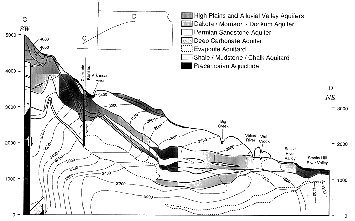
Ground water in the intermediate-scale flow system moves through a hydraulically continuous framework from points of higher elevation to points of lower elevation because of the force of gravity and thus loses potential along the path of movement (Figures 37-39). The eastward-sloping surface topography is a reasonable reflection of the water table from recharge areas in southeastern Colorado-southwestern Kansas to discharge areas in central Kansas. Where no water table aquifer is present, the top of the zone of saturation is considered to be equivalent to the water table.
Figure 37. Location of the two hydrogeologic cross sections in southeastern Colorado and southwestern and central Kansas.
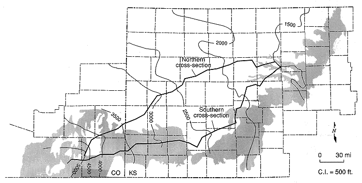
Figure 38. Hydrogeology of the intermediate-scale ground-water flow system in the plane of the northern cross section from southeastern Colorado into central Kansas. The cross section shows the distribution of hydraulic head and the aquifer and aquitard units in the intermediate-scale system. Ground-water flow direction is assumed to be normal to the contours and downgradient from higher to lower hydraulic head values. Vertical exaggeration is 217.6x.
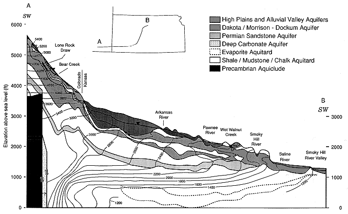
Figure 39. Hydrogeology of the intermediate-scale ground-water flow system in the plane of the southern cross section from southeastern Colorado into central Kansas. The cross section shows the distribution of hydraulic head and the aquifer and aquitard units in the intermediate-scale system. Ground-water flow direction is assumed to be normal to the contours and downgradient from higher to lower hydraulic head values. Vertical exaggeration is 217.6x.
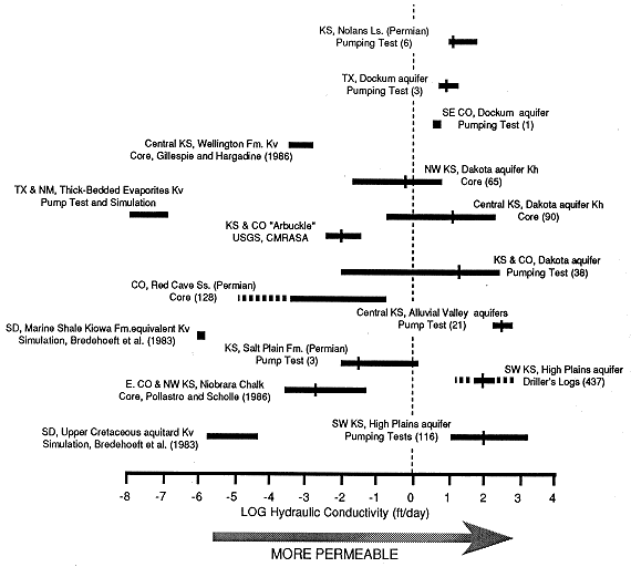
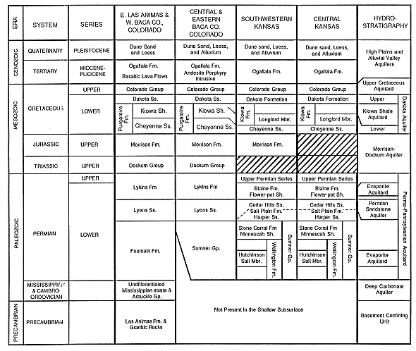
The lithostratigraphy consists of geologic units that, considered as a whole, span a wide range of hydraulic property values (K varies over 11 orders of magnitude) (Table 2 and Figure 40). The lithostratigraphy consists of Cenozoic alluvial and eolian unconsolidated clays, silts, sands, and gravels; Cretaceous marine and non-marine shales, limestones, and sandstones; Jurassic and Triassic non-marine shales, marls, limestones, evaporates, and sandstones; and Permian marine and non-marine shales, mudstones, bedded halite and other evaporates, and sandstones. These lithostratigraphic units are described in more detail later in this section.
Figure 40. Hydraulic conductivity range of variation between aquifer and aquitard hydrostratigraphic units, southeastern Colorado and western and central Kansas and other parts of the Midcontinent. Data compiled from reports of pumping tests, drill stem tests, core analyses, and modeling studies. The size of the data set is in parentheses. Data from modeling studies or single sources are listed as author and date.
The lithostratigraphy forms a framework for regionally significant aquifers and aquitards. The near-surface aquifer in much of southwestern and south-central Kansas and southeastern Colorado is either the High Plains or the Alluvial Valley aquifer system. The High Plains and Alluvial Valley aquifer systems can be separated from the underlying Dakota aquifer by the Upper Cretaceous aquitard in parts of the study area. Underlying the Dakota and the Morrison-Dockum aquifers is the Permian-Pennsylvanian confining unit, which isolates the Permian sandstone and deeper aquifers from overlying aquifers over the western part of the area. However, the Dakota aquifer is hydraulically connected to the Permian Sandstone aquifer in much of central Kansas.
Table 2. Hydrostratigraphic classification of the geologic units in the shallow subsurface beneath southeastern Colorado and southwestern and central Kansas.
The spatial arrangement of aquifer and aquitard units (the hydrostratigraphy) is believed to be an important control on the flow system in the Dakota aquifer in five ways: (1) the Dakota aquifer is regionally more continuous than the High Plains aquifer, is hydraulically connected to vertically adjacent aquifers, and, as a result, is potentially an important path of transmission for ground water from recharge to discharge areas in the regional flow system; (2) the Upper Cretaceous aquitard is patchy in the cross sections but, where present, restricts the amount of recharge to the Dakota aquifer from the overlying High Plains aquifer; (3) recharge from the underlying Permian Sandstone aquifer occurs directly where both aquifers are in physical contact in central Kansas; (4) the primary source of recharge to the Dakota aquifer comes from the water table aquifer in southwestern Kansas and southeastern Colorado where both aquifers are hydraulically connected; and (5) the Dakota aquifer is increasingly more transmissive in an easterly direction toward discharge areas in central Kansas and, as a result, is more effectively connected hydraulically to central Kansas discharge areas than to recharge areas in southwestern Kansas-southeastern Colorado.
The hydrostratigraphy is also an important control on ground-water flow in the Permian Sandstone aquifer. The Permian Sandstone aquifer is recharged by ground waters passing from the overlying Dakota and High Plains aquifers through the overlying Permian aquitard. Discharge from the aquifer occurs where the Permian Sandstone aquifer is hydraulically connected to the Dakota aquifer in central Kansas. The potentiometric surface of the Permian Sandstone aquifer is appreciably below the elevation of the water table in southeastern Colorado-southwestern Kansas because (1) the aquifer is more effectively connected to its discharge area into the Dakota aquifer than sources of recharge and (2) the aquifer transmissivity increases eastward.
The greater topographic relief between stream valleys and interstream areas in central Kansas has resulted in the development of several local flow systems that are superimposed on and dominate the regional flow system near and eastward of the Greenhorn escarpment. These local flow systems are laterally adjacent to each other and are bounded by stream divides. Recharge enters the system in interstream areas and moves relatively quickly to discharge areas in adjacent stream valleys. Because of the considerable topographic relief, local flow systems are vertically extensive and help focus the discharge of deeper, more saline ground waters from the intermediate-scale flow system into stream valleys. Discharge is further enhanced because these local-scale flow systems are situated in areas where the Dakota aquifer is most transmissive and appear to be not as sluggish as the rest of the intermediate-scale flow system. Ground water is discharged at higher rates in central Kansas than can be recharged from adjacent sources in the intermediate-scale flow system. Thus the stream valleys, which are the primary discharge areas for the local-scale flow systems, effectively drain the intermediate-scale flow system, including the Permian Sandstone aquifer.
The geologic evolution of the Rocky Mountain foreland and the High Plains in southeastern Colorado and southwestern and central Kansas has played a significant role in the development of the regional ground-water flow system since early Miocene time, approximately 24 Ma. From early Miocene to Kansan (Pleistocene) time, tectonic activity has uplifted areas nearer the Rocky Mountain front and has tilted southeastern Colorado-southwestern Kansas eastward. In response, hydraulic heads in aquifers nearer the mountains have been increased relative to hydraulic heads in aquifers in central Kansas. Another important consequence was the Pleistocene excavation of the Arkansas River valley by stream erosion in southeastern Colorado. The Arkansas River may capture a significant portion of the recharge entering the flow system in the vicinity of Mesa de Maya and the adjacent area northward to the river in southeastern Colorado. Deposition of the Ogallala, approximately 12-2.5 Ma, has also modified the regional ground-water flow system by further increasing the elevation of the water table. Farther east, Pleistocene erosion of the Ogallala and underlying bedrock in central Kansas by streams lowered the elevation of the land surface but increased the topographic relief The net result of these processes was the development of several laterally adjacent local-scale ground-water flow systems in central Kansas.
Ground water is assumed to move through a continuous framework of unconsolidated and consolidated rock units in response to hydraulic head gradients at rates that are for the most part directly related to the ability of the porous medium to transmit fluid from point to point in the flow system. For the shallow subsurface represented in the two vertical cross sections, the wide range of lithologies represented and the diagenetic and tectonic history indicate an extremely heterogeneous porous medium. The range of hydraulic conductivity values for the aquifer and aquitard units in the shallow subsurface of southeastern Colorado and western and central Kansas spans 11 orders of magnitude. Figure 41 shows the range of variation in hydraulic conductivity between and within aquifer and aquitard units in the vicinity of the two vertical cross sections. The hydraulic conductivity ranges cited in Figure 41 have been compiled from pumping or other hydrologic tests and computed simulations reported in the literature or in unpublished sources. These results show appreciable overlap, at least locally, between hydrostratigraphic units defined as aquifers and aquitards. What is considered an aquifer in some situations may not be considered an aquifer in others because of the relative contrasts in hydraulic conductivity and thickness between the geologic unit(s) in question and adjacent units.
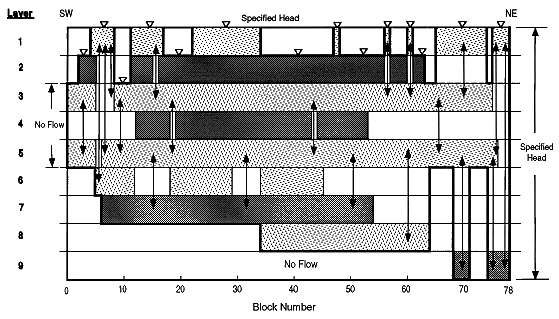
Figure 41. Schematic of the model grid to be used to model ground-water flow in the northern vertical cross section extending from southeastern Colorado into central Kansas. Layer 1 is the High Plains and Alluvial aquifer system; layer 2 is the Upper Cretaceous aquitard; layer 3 is the upper Dakota aquifer; layer 4 is the Kiowa Shale aquitard; layer 5 is the lower Dakota aquifer; layer 6 is the Morrison-Dockum aquifer; layers 7 and 9 are the Permian-Pennsylvanian aquitard; and layer 8 is the Permian Sandstone aquifer. The lower and southwestern boundaries of the model are no-flow and represent the flow line that separates the intermediate from the regional flow system. The upper and northeaster boundaries of the model are specified head and represent the water table and a constant flux boundary respectively. The vertical double-headed arrows represent vertical hydraulic connection between layers where intervening hydrostratigraphic units are missing. The horizontal dimension of each block is variable, ranging up to 5.41 mi. The total length of the vertical cross section is approximately 342.6 mi. The depth to the base of the intermediate system ranges up to 1760 ft. The intersection of the vertical section with the Kansas-Colorado state line is located approximately between blocks 14 and 15; with the Arkansas River, layer 1, block 17; with the Saline River valley, layer 1, block 57; and with the Saline and Smoky Hill rivers, layer 1, blocks 66-74 and 76-78.
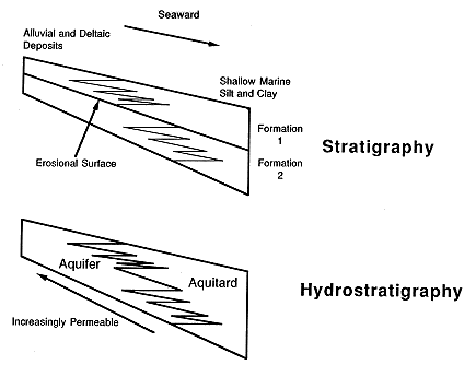
Hydrostratigraphic units are defined in the two cross sections primarily on the basis of the regional distribution of facies types. Facies are subdivisions of stratigraphic units defined on the basis of similar lithology and depositional environment, such as eolian sandstone (Figure 42). In most cases the regional-scale distribution of hydrologic properties within rocks belonging to a particular facies should be relatively homogeneous or functionally related to sedimentary processes within a basin at the time of deposition. Thus delineation of distinct facies assemblages can imply a degree of hydraulic continuity and is a basis for defining distinct hydrologic units.
Figure 42.Hypothetical example showing the comparison between sequence stratigraphic and hydrostratigraphic units. Sequence stratigraphy is the study of rock relationships within a framework of repetitive, related sedimentary deposits, known as sequences, that are bounded by erosional surfaces or surfaces of nondeposition. The bounding surfaces are subaerial unconformities that formed in response to a change in relative sea level. The example shows that hydrostratigraphic units are defined on the basis of rocks that have been deposited in similar geologic environments. Thus more sandy and permeable deposits of the fluvial, coastal-plain, and shore-zone environments are grouped together in one hydrostratigraphic unit, and the less permeable marine deposits are grouped into another unit in each depositional sequence.
High Plains and Alluvial Valley Aquifers
The High Plains and Alluvial Valley aquifers consist of Cenozoic unconsolidated to partly consolidated eolian, fluvial, and lacustrine deposits. This facies includes all of the Ogallala Formation and Quaternary deposits. Ogallala Formation and associated Quaternary alluvial, eolian, and lacustrine deposits make up the High Plains aquifer framework in western Kansas and eastern Colorado. The Ogallala Formation is composed of unconsolidated, poorly sorted to well-sorted sands and gravels, silts, clays, and volcanic ash that were deposited in an aggradational regime in abandoned stream valleys and other topographically low areas. In central Kansas the Alluvial Valley aquifers consist of Quaternary alluvial and eolian deposits. The Quaternary deposits are principally alluvial valley fills that were deposited between cycles of stream rejuvenation and active downcutting. The total saturated thickness of deposits associated with this facies ranges up to approximately 370 ft in southwestern Kansas. In central Kansas the saturated thickness of the alluvial deposits is generally less than 75 ft and is usually 40 ft or less. The High Plains and Alluvial Valley aquifers are bounded above by the water table and below by the Upper Cretaceous aquitard, the Dakota aquifer, or the Permian-Pennsylvanian aquitard. On a regional scale groundwater flow is assumed to be horizontal under unconfined conditions with vertical leakage through aquitards.
Pumping tests and other data sources show that the High Plains and Alluvial Valley aquifers are extremely permeable relative to aquifer units in the older consolidated rock units. The geometric mean hydraulic conductivity of this lithofacies south of T. 11 S. is 103 ft/day based on the results of 116 pumping tests (range of 12-1600 ft/day). However, drillers' logs and representative values of hydraulic conductivity for the lithologies penetrated by the test holes and wells has been used to better define the spatial variation of hydraulic conductivity. The overall arithmetic mean computed for hydraulic conductivity is 79.6 ft/day (standard deviation of 38.7 ft/day) in the southwest Kansas region. In the Smoky Hill River alluvium at Solomon, Kansas, the geometric mean hydraulic conductivity was 153 ft/day from 16 slug tests of piezometers. Upstream in Ottawa County, hydraulic conductivity values of 241 ft/day and 477 ft/day were reported from two pumping tests with observation wells in the Solomon River alluvium. Farther south in the Wet Walnut Creek valley, hydraulic conductivity values ranges from 221 ft/day to 382 ft/day from the three pumping tests.
Upper Cretaceous Aquitard
The Upper Cretaceous aquitard consists of thick sequences of rhythmically bedded chalk and chalky shale and massively bedded chalky limestone, shale, and siltstone. Strata from the Graneros Shale, the Greenhorn Limestone, the Carlile Shale, and the Niobrara Chalk belong to this facies. Both the thickness and the distribution of this aquitard are highly variable in the region traversed by the two vertical cross sections because of Cenozoic erosion. The total thickness of this aquitard ranges up to more than 900 ft and up to approximately 180 ft along the northern and southern sections, respectively. As a result, the gross lithology of the aquitard varies somewhat from place to place in the region. Nearer the outcrop of the stratigraphic units shale and chalky to calcareous shale predominate, but where the Niobrara Chalk is present, the proportion of chalky to calcareous shale increases and becomes the predominant lithology of the aquitard. The Upper Cretaceous aquitard is bounded above by the water table and the High Plains and Alluvial Valley aquifers in west-central, south-central, and central Kansas and below by the Dakota aquifer over the entire region. Ground-water flow through the aquitard is assumed to be primarily vertical leakage to underlying aquifers in western and central Kansas and southeastern Colorado.
Estimates of hydraulic conductivity for the Upper Cretaceous aquitard in Kansas are meager. Intrinsic permeability of core samples from the Beecher Island zones (Niobrara Chalk) in the shallow gas fields of eastern Colorado ranged from 0.1 md to 16 md (2.7 x 10⁻⁴ to 0.04 ft/day) with an average permeability of 1 md (0.003 ft/day). The vertical hydraulic conductivity of the Upper Cretaceous aquitard was estimated in South Dakota from field tests, core consolidation tests, and ground-water flow models of the aquitard. The aquitard in South Dakota includes the Pierre Shale, a stratigraphic unit not encountered in this study. The vertical hydraulic conductivity ranged from 5 x 10⁻⁸ from soil consolidation tests to 5 x 10⁻⁴ ft/day from simulation models. In one simulation of the flow system, the best-fitting hydraulic conductivity of the Carlile Shale was determined to be 2 x 10⁻⁵ ft/day. In another model simulation the best-fitting hydraulic conductivity for the entire aquitard was 3.5 x 10⁻⁵ ft/day. Farther south in the Denver basin of eastern Colorado, southeastern Wyoming, Nebraska, and Kansas, the results of earlier modeling studies yielded a lower range of 4.1 x 10⁻⁹ ft/day to 1.2 x 10⁻⁶ ft/day for vertical hydraulic conductivity.
Dakota Aquifer
The Dakota aquifer consists of deposits belonging to the Dakota Formation (Kansas) and Dakota Sandstone (Colorado), the Longford Member (Kiowa Formation), the Cheyenne Sandstone, and the lower portion of the Purgatoire Formation (Colorado) (Table 2). Strata within these units are included in the Lower Cretaceous fluvial to lower shoreface deposits facies. The rocks within this facies consist of lenticular fluvial and deltaic sandstones interbedded with mudstone and were deposited during several periods of marine transgression. In much of the area the Dakota aquifer is separated into upper and lower portions by the Kiowa Shale aquitard. Above the aquitard the upper portion of the Dakota aquifer consists of the Dakota Formation (Kansas) and the Dakota Sandstone (Colorado). Below the aquitard the Dakota aquifer consists of the Longford Member (Kiowa Formation) and the Cheyenne Sandstone, which make up the lower portion of the Purgatoire Formation in Colorado. The combined thickness of the upper and lower portions of the Dakota aquifer ranges up to 300 ft in southeastern Colorado and up to 450 ft in central and west-central Kansas (Figure 43). In part of the southeastern Colorado and western and central Kansas region, the Dakota aquifer is bounded above by the Upper Cretaceous aquitard or the High Plains and Alluvial Valley aquifers. Elsewhere the Dakota aquifer is the uppermost aquifer. The Dakota aquifer is bounded below by the Permian-Pennsylvanian aquitard or the Morrison-Dockum aquifer. In the two cross sections the Dakota and the Morrison-Dockum aquifers and the High Plains and Alluvial Valley aquifers are considered to be hydraulically connected where they overlie one another. Ground-water flow in the Dakota aquifer is assumed to be primarily in the horizontal direction with leakage to vertically adjacent aquitards. The Dakota aquifer is recharged directly by precipitation or through hydraulic connection to the overlying High Plains and Alluvial Valley aquifers and underlying Permian Sandstone aquifer.
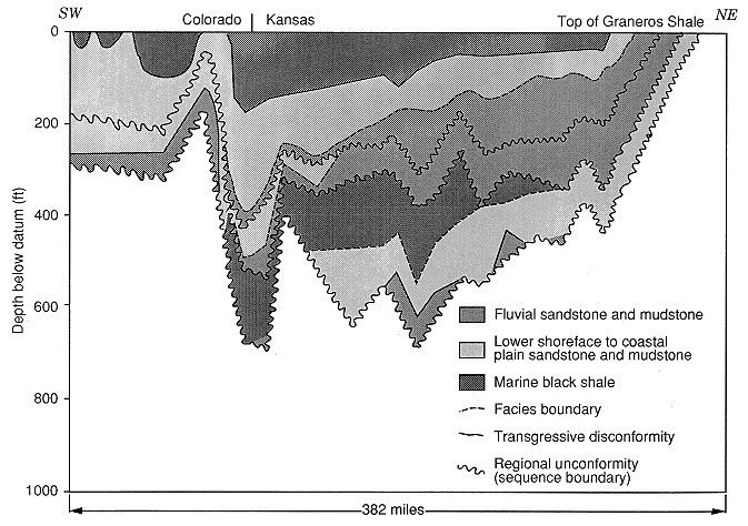
Figure 43. Schematic diagram of the sedimentary architecture of the Dakota aquifer and overlying Graneros Shale along the northern cross section showing the subdivision of the aquifer framework into fluvial sandstone and mudstone, lower shoreface to coastal plain sandstone and mudstone, and marine black shale deposits. Vertical exaggeration is 2261x.
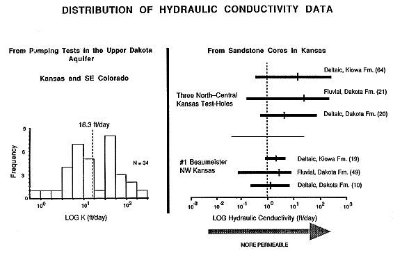
The primary aquifer units consist of lenticular sandstone bodies, which may be laterally or vertically interconnected. These sandstones are embedded in less permeable mudstones. Although the Dakota aquifer is extremely heterogeneous spatially, conceptually the aquifer framework can be thought of as consisting of two components, a more permeable portion (the sandstones) and a less permeable but porous matrix (the mudstones). In the southeastern Colorado and Kansas region, the geometric mean hydraulic conductivity for the Dakota aquifer is approximately 19 ft/day based on the results of 342 pumping tests (range 1-233 ft/day) (Figure 44). Hydraulic conductivity data for sandstone cores from the stratigraphic units that comprise the Dakota aquifer have a geometric mean of 4.8 ft/day based on 172 samples collected from a variety of depositional environments and localities in Kansas (range O.018-219 ft/day). The geometric means of the horizontal and the vertical permeability (from cores) of Dakota sandstones penetrated three test holes in north-central Kansas are 4,900 md (13.4 ft/day) and 1,930 md (5.3 ft/day), respectively. In contrast, the geometric means of horizontal and vertical permeability (all from cores) are 240 md (1.7 ft/day) and 380 md (1.0 ft/day), respectively, in the No. 1 Beaumeister borehole in northwest Kansas. In southwestern Kansas and southeastern Colorado, data from pumping tests show that the Dakota aquifer is less permeable (<10 ft/day) than in central Kansas (>40 ft/day). These data suggest that westward from north-central Kansas the permeability of fluvial and deltaic sandstones decreases into the Denver basin.
Permeability of Dakota aquifer sandstones in Kansas and in the Denver basin is a function of depositional environment, diagenesis, and postdiagenetic history (Figure 44). Sandstones closer to the axis of the Denver basin were deposited in marine and coastal plain environments and are clayey, tightly cemented, and less permeable. However, microfractures in cemented sandstones may significantly enhance the vertical component of hydraulic conductivity. Farther east in central Kansas, the sandstones were deposited in both coastal and fluvial environments and are less well cemented to unconsolidated and more permeable.
Figure 44. Distribution of hydraulic conductivity data for the Dakota aquifer of Kansas from pumping tests of the aquifer and permeameter tests of core samples from north-central and northwest Kansas test drilling. Test results from the core samples are subdivided according to depositional environment. The figure shows that (1) the pumping test results overlap the spread of results from the core permeameter tests and (2) the range of values and geometric means of the hydraulic conductivity data arranged by depositional environment from the north-central Kansas test drilling are greater than for the data from the No. 1 Beaumeister. The volume in parentheses is the number of core samples tested.
Kiowa Shale Aquitard
The Kiowa Shale aquitard consists of marine shales of the Kiowa Formation (Kansas) and Kiowa Shale Member of the Purgatoire Formation (Colorado) (Figure 43 and Table 2). The predominant lithology of this facies is black laminated marine shale with minor intermittent occurrences of coquina limestone near the base and top of the aquitard. The strata within this facies are time equivalent to more permeable strata in the Longford Member of the Kiowa Formation. The thickness of the aquitard ranges up to 370 ft within its extent in the two cross sections. The aquitard is not present on the Sierra Grande uplift in eastern Las Animas and Baca Counties, Colorado, and in much of central Kansas in the vicinity of the Central Kansas uplift. In these areas only the Longford Member is present in the Kiowa Formation. Ground-water flow in the aquitard is primarily in the vertical direction as leakage from overlying aquifer units.
Hydraulic conductivity data for the Kiowa Shale aquitard are not available in Kansas and Colorado. However, researchers working in South Dakota estimated a vertical hydraulic conductivity of 1.3 x 10⁻⁶ ft/day for the Skull Creek Shale, a stratigraphically equivalent unit to the marine shale facies of the Kiowa Formation in Kansas and the Kiowa Shale Member of the Purgatoire Formation in southeastern Colorado.
Morrison-Dockum Aquifer
The Morrison-Dockum aquifer consists of strata belonging to the Jurassic-Triassic Morrison formation and Dockum Group and includes alluvial fan, lacustrine, deltaic, and coastal plain deposits. Alluvial fan, fluvial, and deltaic sandstone, sandy to shaly mudstone and silty shale, marly to cherty shale, and freshwater limestones and minor evaporates characterize this facies. The Dockum Group represents the northernmost extension of a sequence of primarily clastic continental deposits that filled Permian basins centered in the Texas Panhandle and eastern New Mexico. The Morrison formation strata were deposited on an extensive coastal plain in Colorado and western Kansas and the northern plains. The thickness of the Morrison-Dockum aquifer ranges up to more than 650 ft in southeastern Colorado. The Dockum is not present in the Kansas portion of the two cross sections. Ground-water flow is assumed to be generally in the horizontal direction within the aquifer with some downward leakage to the underlying Permian-Pennsylvanian aquitard. The Morrison-Dockum aquifer is recharged by ground waters moving downward from the Dakota and High Plains and Alluvial aquifers and directly from precipitation where the strata that make up the aquifer crop out at the surface in the Purgatoire River valley.
Hydraulic conductivity data for the Morrison-Dockum are limited in the project area. Data from Colorado are sparse; a hydraulic conductivity of 4.7 ft/day was calculated from specific capacity data collected from a well in Baca County. The results of three pumping tests for the Dockum in Texas range from 4.7 ft/day to 14.1 ft/day (geometric mean of 7.5 ft/day). The Morrison formation is generally not considered a regional aquifer in southeastern Colorado. However, the Morrison is sandy and probably does transmit water to underlying hydrostratigraphic units in several areas of southeastern Colorado and extreme southwestern Kansas.
Permian-Pennsylvanian Aquitard
The Permian-Pennsylvanian aquitard consists primarily of non-marine to restricted marine mudstone, sandy mudstone, and minor sandstone with interbeds of anhydrite, gypsum, and dolomite. In eastern Las Animas and western Baca counties, Colorado, the predominantly mudstone character of the aquitard changes to sandstone, shaly sandstone, and calcite- and dolomite-cemented sandstone. Gypsum and anhydrite commonly occur in the Blaine Formation throughout the region and in the Stone Corral Formation in central and western Kansas and in eastern and central Baca County. In parts of southwestern Kansas the Stone Corral Formation thickens up to more than 100 ft and contains a thin zone of bedded halite approximately 20 ft thick. This hydrostratigraphic unit contains locally developed permeable zones in the near surface because of dissolution of evaporates. Elsewhere, carbonate and evaporate units within the aquitard may be sufficiently permeable to be considered aquifers, such as in the Day Creek Dolomite. The Permian-Pennsylvanian aquitard is bounded above by the Morrison-Dockum and Dakota aquifers over most of southeastern Colorado and western and central Kansas. At the northeastern end of both vertical sections the aquitard underlies the Alluvial Valley aquifer of the Smoky Hill River valley. At the southwestern end of both cross sections on the Sierra Grande uplift, the Permian-Pennsylvanian aquitard overlies the Deep Carbonate aquifer at shallow depths. The lower Pennsylvanian portion of this aquitard is not present in the shallow subsurface in most of the region traversed by both cross sections. Within the aquitard are the Evaporite aquitard and the Permian Sandstone aquifer. These hydrostratigraphic units are discussed later. Ground-water flow in the aquitard is assumed to be primarily in the vertical direction to underlying aquifers in southwestern Kansas and southeastern Colorado and to overlying and underlying aquifers in central Kansas. In central Kansas solution of bedded salt and carbonates in the Hutchinson Salt Member and collapse of overlying shales along the outcrop has produced the Wellington aquifer. This aquifer consists of brecciated and solutioned evaporitic shales of the Wellington Formation and underlying Nolans Limestone. Within the cross sections the Wellington aquifer underlies the alluvial aquifer of the Smoky Hill River.
Hydraulic conductivity data that pertain to the Permian portion of the Permian-Pennsylvanian aquitard are meager in Kansas except in shallow near-surface environments. Hydraulic conductivity data for the siltstone and sandy siltstone portion of the Permian-Pennsylvanian aquitard are limited to a few slug tests in Stafford County Kansas. The data range of four tests is 0.006-0.964 ft/day (geometric mean value of approximately 0.03 ft/day). Permeability data collected from whole-core analyses of the Permian Red Cave Sandstone in Baca County, Colorado, range from <O. 1 to 48 md (<2.74 x 10⁻⁴ to 0. 13 ft/day hydraulic conductivity). The lithology of the Red Cave is reported to be silty to shaly sandstone containing anhydrite. Several zones of vertical fracturing are also noted in the core description. The hydraulic conductivity range from six slug tests of piezometers in the solutioned Nolans Limestone at Solomon, Kansas, is 4.1-45.5 ft/day (geometric mean hydraulic conductivity of 13.2 ft/day). The vertical hydraulic conductivity of brecciated Wellington Formation shale from tests on a core collected in the Solomon area ranges from 1.2 x 10⁻³ ft/day to 3.4 x 10⁻⁴ ft/day. Hydraulic conductivities derived from drill-stem tests on a similar facies in Texas, the San Andres Formation, are 0.0002-0.001 ft/day. In a solution collapse zone in the San Andres Formation a hydraulic conductivity of 1.5 ft/day was measured by researchers working in Texas.
Evaporite Aquitard
The Evaporite aquitard is included in the Permian-Pennsylvanian aquitard and consists of (1) halite- and anhydrite-cemented eolian sandstone in the Cedar Hills Sandstone below the Flower-pot salt and (2) thick zones of halite and other minor evaporates with thin lenticular interbeds and a matrix of red mudstone in the Flower-pot Shale and Hutchinson Salt Member of the Wellington Formation that precipitated in restricted marine environments. The strata that form the aquitard belong to the Permian thick-bedded evaporates facies. The thickness of salt in the Hutchinson Salt Member ranges up to more than 400 ft and in the Flower-pot Shale and overlying Blaine Formation up to more than 300 ft in the cross sections that extend across western and central Kansas. Ground-water flow is assumed to be vertically through the salt beds through fractures and along crystal boundaries to underlying units as leakage.
No hydraulic conductivity data are available for the Kansas bedded salt sections. However, other related Permian bedded salts and interbedded siltstones have been investigated near Carlsbad, New Mexico, at the Waste Isolation Pilot Project and in modeling studies of the Palo Duro Basin of Texas. Estimates of vertical hydraulic conductivity from these studies are in the range of 10-7 to 10-8 ft/day. On this basis it is appropriate to assign a vertical hydraulic conductivity of 10-8 ft/day to the bedded halite in the Evaporite aquitard.
Permian Sandstone Aquifer
The Permian Sandstone aquifer is contained within the thicker Permian-Pennsylvanian aquitard and consists of strata belonging to the Cedar Hills Sandstone, the upper part of the Salt Plains Formation in Kansas and the Lyons Sandstone in southeastern Colorado. Interbedded red mudstone, sandy mudstone, and eolian medium to fine-grained, well-sorted sandstone and feldspathic sandstone are the predominant rock types in this unit. Sandstone makes up more than 80% of the unit locally. In the subsurface the sandstones are frequently described by drillers as "free drilling," which implies that they are friable and not well cemented. Thickness of this aquifer unit ranges up to more than 300 ft in parts of central Kansas and in eastern Las Animas and western Baca counties, Colorado. In extreme western Kansas and eastern Baca County the Permian sandstone aquifer is approximately 100 ft thick where it underlies bedded salt in the Flower-pot Shale. Ground-water flow is assumed to be primarily in the horizontal direction in the aquifer. The aquifer is recharged indirectly through overlying portions of the Permian-Pennsylvanian aquitard and contributes leakage to underlying units through the aquitard. The Permian Sandstone aquifer discharges ground water in central Kansas vertically to the overlying Dakota aquifer where they are in contact and where the aquitard is thin or fractured.
Hydraulic conductivity data for the Permian Sandstone aquifer are limited to the results of a few slug tests in south-central Kansas. The range for three tests on the aquifer conducted in Stafford County, Kansas, is 0.008-14.7 ft/day (geometric mean of approximately 0.6 ft/day). The upper end of the hydraulic conductivity range probably reflects sandstones containing less silt and clay content and less cementation and is probably more representative of the Permian Sandstone aquifer in central Kansas.
Deep Carbonate Aquifer
The Deep Carbonate aquifer consists of undifferentiated Mississippian, Ordovician, and Cambrian limestones, dolomites, and sandy dolomites. Permeable zones exist within the aquifer where karst surfaces have developed as a result of subaerial exposure and development of ancient ground-water flow systems. This aquifer is bounded below by Precambrian rocks that serve as an aquiclude in the regional ground-water flow system and above by the Permian-Pennsylvanian aquitard. The Deep Carbonate aquifer is in the shallow subsurface only in southeastern Colorado on the Sierra Grande uplift where it is part of an uplifted fault block. Elsewhere in the region traversed by the vertical cross sections, the aquifer is at least several thousand feet below land surface and is not considered in this study. The Deep Carbonate aquifer is recharged from leakage through the overlying Permian-Pennsylvanian aquitard. Few hydraulic conductivity data are available from core analyses and drill-stem tests associated with oil and gas exploration along the cross sections. The Deep Carbonate aquifer is believed to be only slightly permeable (K = 0.003 ft/day for the lower portion and K = 0.03 ft/day for the upper portion). Therefore the average hydraulic conductivity of the Deep Carbonate aquifer is approximately 0.009 ft/day based on the relative thicknesses of the upper and lower portions of the aquifer in the shallow subsurface of southeastern Colorado.
Simulation in FY92 will be carried out using MODFLOW, a quasi-three-dimensional finite-difference ground-water flow model that was selected for this research project because (1) the variation in ground-water density resulting from salinity and thermal effects is minimal, (2) the modeling package is designed to deal with layered aquifer systems and heterogeneous aquifers, and (3) the modular nature of the model makes it easy to use. In MODFLOW layers can be simulated as confined, unconfined, or a combination of confined and unconfined. Flow from external stresses, such as drains, wells, areal recharge, evapotranspiration, and rivers, can be simulated. The modular structure of the computer program consists of a main program and a series of subroutines called modules. These subroutines are grouped into packages. Each package deals with a specific feature of the hydrologic system to be simulated with a numerical technique. The model uses a block-centered backward difference approximation to solve the flow equation. The user can choose either the strongly implicit procedure or the slice successive over-relaxation technique for solving the finite-difference equations. Figure 41 is a graphical representation of the preliminary modeling grid that will be used to simulate the ground-water flow system in the plane of the northern cross section through the study area.
The objectives of the modeling effort are to determine the mass balance through the system and assess the effects of the Upper Cretaceous aquitard, the High Plains aquifer, the Arkansas River, and the Dakota aquifer on regional flow and the effects of local-flow systems in the Saline and Smoky Hill River valleys on discharge from the Dakota and Permian Sandstone aquifers. For the effects on regional flow, simulations will also be performed to assess the effect of nonuniform hydraulic conductivity in the Dakota aquifer on the flow field. The results from this modeling effort should, in general, greatly improve our understanding of the relationship between the Dakota aquifer and the intermediate-scale system of ground-water flow in southeastern Colorado and Kansas. Specifically, the results should demonstrate that the spatial arrangement of aquifer and aquitard units and the surface topography are important factors controlling the ground-water flow field, the sources of recharge to the intermediate-scale ground-water flow system, and groundwater quality.