Kansas Geological Survey, Open-File Rept. 91-1
Annual Report, FY91--Page 2 of 8
Figure 1. Extent of the Dakota aquifer in Kansas.
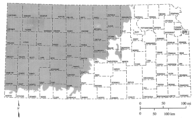
Figure 2. Stratigraphic and hydrostratigraphic classification of units that comprise the Dakota aquifer in Kansas.
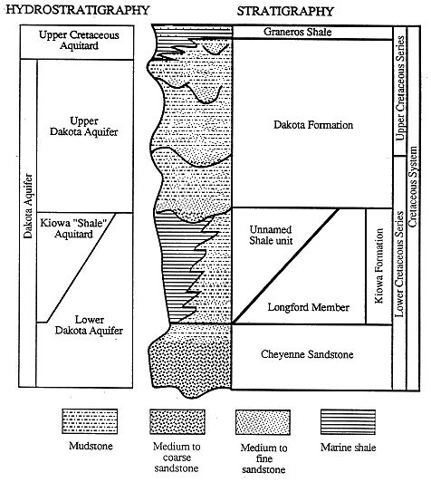
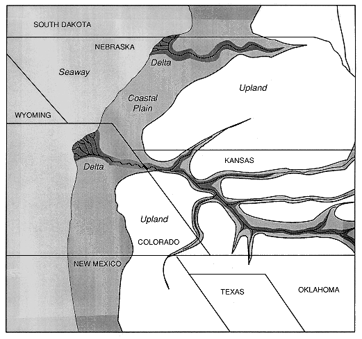
Figure 3. Midcontinent geography during deposition of the middle portion of the Dakota aquifer approximately 97 million years ago (early Dakota time).
The Dakota is the near-surface aquifer in southeastern Colorado and southwestern and central Kansas. In most of southwestern Kansas and southeastern Colorado the Dakota aquifer underlies and is hydraulically connected to the overlying High Plains aquifer. Elsewhere, younger shales, chalks, and limestones of Cretaceous age overlie the Dakota aquifer. The main pattern of ground-water flow in the Dakota aquifer is from recharge areas in southeastern Colorado and southwest Kansas to discharge areas in the river valleys of central and north-central Kansas (Figure 4). The Dakota aquifer is recharged by precipitation in the outcrop areas of southeastern Colorado and central Kansas, by the overlying Ogallala and alluvial valley aquifers in southwest Kansas, and by the underlying Cedar Hills aquifer where both aquifers are hydraulically connected in the central part of the state.
Figure 4. Predevelopment potentiometric surface of the Dakota aquifer.
Within the Dakota aquifer the transmission of water laterally and vertically depends on the hydraulic connection of sandstone aquifers, including fractures that penetrate interbedded shales and on the hydraulic properties of the sandstones. In addition, the hydraulic properties and interconnections between sandstones also affect sustained well yields.
Freshwaters occur along the eastern outcrop area, part of the eastern subcrop adjacent to the outcrop zone, and in the subcrop area of the Dakota aquifer in southwestern Kansas. The rates of change in dissolved-solids contents with distance are greatest along the eastern-most subcrop from Republic County to Barton County. Saltwater in the Dakota aquifer in central Kansas is geochemically identified as being derived primarily from solution of halite (rock salt) in underlying Permian rocks. The upward movement from the Permian is affected by pinching out of confining layers and the presence of fractures and other geologic structures.
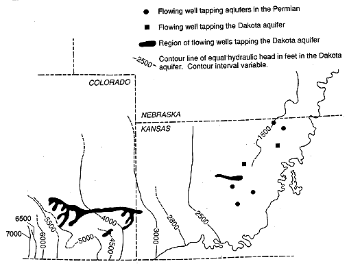
The Dakota aquifer has been used as a source of water in southeastern Colorado and Kansas for nearly a century. Currently, the Dakota is used for irrigation, public water supply, and industry in southeastern Colorado and southwestern and central Kansas. Reported well yields range up to 2,000 gallons per minute in central and southwestern Kansas and southeastern Colorado. Rates of withdrawal greatly exceed recharge to the system in Kansas and eastern Colorado. In Kansas approximately 96% of the total volume of ground water withdrawn from the Dakota is from southwestern and south-central parts of the state. Long-term historical records of water levels for assessing the effects of development are virtually nonexistent except for published reports from the early 1900's. What limited data exist suggest that water-level declines are of the order of 50 ft or less in the southeastern Colorado-southwestern Kansas area where flowing artesian wells in the aquifer were common in the Arkansas River valley (Figure 5). Now, flowing artesian wells are rare where development has been heaviest. The data suggest that water-level declines are of the order of 10 ft or less where development has been less extensive.
Figure 5. Areas of artesian flow in the Dakota aquifer mapped by Darton in 1904.
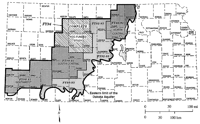
The overall objectives of the Dakota aquifer program in FY90-94 are (1) to characterize subregionally the water resources potential of the areas where the Dakota aquifer is shallowest and is undergoing development in central and southwestern Kansas (Figure 6) in FY90-91 and (2) to develop conceptual models of ground-water flow and assess water-planning and regulatory scenarios in FY92-94.
Figure 6. Extent of the Dakota aquifer in Kansas and subareas of investigation.
This annual report of the Dakota aquifer program summarizes the activities and results for FY91. Details concerning specific areas of research in the program completed during FY91 are reported as stand-alone chapters. Technical papers from the Dakota aquifer program will continue to be reported in the Kansas Geological Survey's Open-File Report series. Each annual report will be given a number, such as 92-1, and each chapter will be given the same number followed by a letter of the alphabet that corresponds to its position in the sequence of reports for that year, such as 92-1a.
The following FY91 tasks and milestones were accomplished on the geologic framework of the Dakota aquifer: (1) digitizing of borehole geophysical logs to increase the density of coverage in southwestern and south-central Kansas was completed; (2) the geologic data base in that area of the state was expanded; (3) the feasibility of using borehole geophysical logs for delineation of hydrostratigraphic units was assessed; and (4) a detailed analysis of the Dakota aquifer framework in southwestern and south-central Kansas using sequence stratigraphic techniques was completed.
The following FY91 tasks and milestones were accomplished on the geohydrology of the Dakota aquifer: (1) monitoring sites in Lincoln, Cloud, Hodgeman, and Finney counties were constructed to obtain hydrologic properties and chemical-quality data; (2) hydrologic testing of the Lincoln and Cloud county monitoring sites; (3) the geohydrology study in Washington, eastern Republic, and northern Cloud counties was completed; and (4) a study to determine the factors controlling the predevelopment (steady-state) regional flow system in southeastern Colorado and southwestern and central Kansas using cross-sectional models was continued.
The following FY91 tasks and milestones were accomplished on the geochemistry of the Dakota aquifer: (1) water samples from wells in Southwestern and central Kansas were collected and analyzed for water-quality assessment of Dakota ground waters, and the results were entered into the water-quality data base; (2) work to produce ground-water chemistry atlases was begun; (3) a use assessment of the quality of water supplies was continued; and (4) the assessment of coupled geochemical and mass transport models to simulate chemical reactions and transport along flow paths in the Dakota aquifer was continued.