


Kansas Geological Survey, Open-File Rept. 91-1
Annual Report, FY 90--Page 5 of 9
A survey of water levels in wells screened in the Dakota aquifer was made in February and March 1990 in southeastern Colorado by the U.S. Geological Survey and in southwestern and central Kansas by the Kansas Geological Survey and the Division of Water Resources, Kansas Board of Agriculture. The number of well measurements made from the field survey is tabulated by state and county in Table 2. A total of 250 water-level measurements were made during the survey. Fewer measurements were made than anticipated because the irrigation season started earlier than anticipated in southwestern Kansas and southeastern Colorado. In addition the U.S. Geological Survey had considerable difficulty in finding suitable well sites for water-level measurements because their GWSI data base for southeastern Colorado was outdated. They had to rely on information without field checks from the Colorado Division of Water Resources. In Kansas, many of the well-sites listed in the initial well inventory also had not been field-checked previously to verify their existence or location.
Table 2. Water-level measurements made during the FY90 field survey of wells screened in the Dakota aquifer of Kansas and southeastern Colorado listed by state and county.
| State | County | Number of Water-Level Measurements |
|---|---|---|
| Kansas | Hodgeman | 29 |
| Ford | 25 | |
| Stanton | 5 | |
| Kearny | 17 | |
| Grant | 4 | |
| Haskell | 1 | |
| Rush | 7 | |
| Finney | 6 | |
| Ness | 4 | |
| Gray | 3 | |
| Hamilton | 4 | |
| Washington | 29 | |
| Cloud | 8 | |
| Republic | 6 | |
| Ottawa | 7 | |
| Lincoln | 3 | |
| Colorado | Baca | 67 |
| Prowers | 25 | |
| TOTAL | 250 |
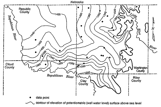
This most-recently collected water-level information is being used during FY90-91 to develop an up-to-date characterization of the ground-water flow system in the Dakota aquifer in areas of southeastern Colorado and southwestern and central Kansas. A combined potentiometric surface and water-table configuration map is being generated from the static water-level data collected from the field. The potentiometric-surface map for an aquifer is produced by contouring the elevation measurements of static water-levels taken in a large number of wells that are open to the aquifer in the geographic area of interest. For confined aquifers the direction of ground-water flow is indicated by the configuration of the potentiometric surface. In unconfined aquifers the horizontal directions of flow are indicated from the configuration of the water-table surface. For both cases the direction of ground-water movement is from areas of higher static-water level elevation to areas of lower elevation perpendicular to the orientation of the contours on the map. Figure 11 is a preliminary combined potentiometric surface and water-table configuration map of the Dakota aquifer in parts of Washington, Republic, and Cloud counties using 1990 data. This map portrays both the potentiometric surface and water-table configuration because there are areas of the map where the the Dakota aquifer is confined and areas where it is unconfined.
Figure 11. Configuration of the combined potentiometric and water-table surfaces of the Dakota aquifer in parts of Washington, Republic and Cloud counties.
Dakota Aquifer Properties From Core Analyses
The cores obtained in FY90 from test drilling, mentioned earlier in the Geologic Framework portion of this report, were also used to develop a core permeability data base. This data base is being used to develop hypotheses concerning the factors that control the distribution of permeability in Dakota aquifer sandstones. Conceptually the aquifer framework can be thought of simply as consisting of a more permeable portion (the sandstones) embedded in a less permeable but porous medium (the finer-grained shaly portion). The porosity of the aquifer materials that comprise the Dakota is the relative proportion of void space between the grains. The high porosity of the mudstones in the aquifer framework acts as a reservoir that releases ground water only very slowly to the sandstone aquifers as they are pumped by wells. In contrast, the more permeable sandstones are capable of transmitting appreciable quantities of ground water to wells during pumping, as well as having substantial storage properties. As a result, the intrinsic permeability of the sandstone component of the Dakota aquifer is an important parameter that partly determines the rate of well discharge from the aquifer. Intrinsic permeability is a measure of the ease with which water will flow through the aquifer and is based on aquifer framework characteristics. Presently, the ability to apply this conceptualization is extremely limited due to the paucity of data on the properties of the Dakota aquifer framework that determine the ability of the aquifer to transmit and store water.
Research completed during FY90 shows that the sandstones are less porous and permeable nearer the Kansas-Colorado state line than they are in central Kansas. The average horizontal and vertical hydraulic conductivity (from cores) and porosity (from geophysical logs) of Dakota sandstones penetrated by the three test holes in north-central Kansas are 13.4 ft/day, 5.3 ft/day, and 33%, respectively. In contrast, the average horizontal and vertical hydraulic conductivity and porosity (all from cores) are 1.7 ft/day, 1.0 ft/day, and 27.5%, respectively, in the #1 Beaumeister a test well that was drilled for oil exploration in northwest Kansas. The property differences shown above are directly related to the cementation and grain size of Dakota aquifer sandstones between western and central Kansas. The more highly cemented the sandstone and the smaller the grain size, the more likely it is that the sandstone will be less porous and less permeable than those that are less well cemented and coarser grained. This occurs because there is more pore space and pathways of travel through the coarser-grained less well-cemented sandstone. Several of the north-central Kansas cores obtained from test-hole drilling contained uncemented zones in thick lenses of cemented sandstone.
Development of Methodologies to Analyze Pumping-Test Results in Buried Stream Channels
The pumping test has traditionally been one of the primary field methods used by hydrogeologists to improve their understanding of conditions in the subsurface. A pumping test can provide information about transmissive and storage properties of a geologic unit, the nature of the lateral and vertical boundaries of the flow system, and the conditions within, and in the immediate vicinity of, the pumping well. The conventional methods for analysis of pumping-test data are based on the assumption that the transmissive and storage properties of the unit being pumped are the same everywhere within that unit. However, in complex geologic settings such as that presented by the Dakota aquifer, this assumption is clearly not true. In FY90, research efforts have been directed to the development of new methodologies for pumping tests in complex geologic settings. Special emphasis was placed on the development of methodology for pumping tests in buried stream channels, a common feature in the Dakota aquifer. Methods were developed that enable the analyst to identify when a buried stream channel is acting as a significant influence on drawdown behavior during a pumping test. Spatial and temporal strategies for efficient data collection were recommended. An example analysis was performed using data previously published in the literature to demonstrate the viability of the proposed approach. A well-test analysis program, SUPRPUMP, which allows the automated analysis of well tests in complex geologic settings, was written and tested. Although the primary emphasis of the work in FY90 was on theoretical development, this work will serve as the underpinnings for the program of pumping tests in the Dakota aquifer that is a major focus of FY91 activities.
Dakota Aquifer Pumping Test in Washington County
Pumping tests provide invaluable information concerning the response of the aquifer to pumping and the properties of the aquifer framework. They can also be used to estimate the leakage from less permeable sediments which overlie and confine the aquifer. These aquifer properties are determined by analysis of measurements of water-level drawdown in an observation well during constant-rate pumping of a nearby well.
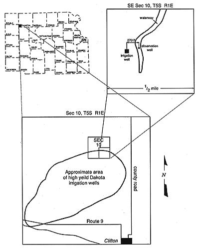
Little is known about the Dakota aquifer in north-central Kansas, although it is used quite extensively as a source of water for irrigation. Therefore, in early May 1990 a pumping test was conducted at a site near Clifton in southwestern Washington County in a thick fluvial sandstone. The observation well was located 270 ft. (82 m) from a high-yield irrigation well on the edge of a waterway near the center of the SE sec. 10, T. 5 S., R. 1 E. (Figure 12). During the test, depth to water measurements were recorded to the nearest 0.01 ft. (0.003 m) in the observation well to determine the drawdown in the aquifer resulting from pumping.
Figure 12. Location of the pumping test site in SE Sec. 10, T. 5S., R. 1 E., southwestern Washington County.
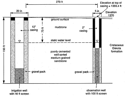
The computer program SUPRPUMP, recently developed by the Kansas Geological Survey for analysis and design of pumping and slug tests, was used to analyze the first 27 hrs. of the time-drawdown data collected during the test. Using the computer program, the hydraulic conductivity, a measure of the ability of the aquifer to transmit water, was estimated to be equal to 78 ft./day. For comparison, the average hydraulic conductivity of the Ogallala aquifer in western Kansas is 80 ft./day. This value of hydraulic conductivity is more typical of an unconsolidated sand than a cemented sandstone and probably results from the lack of cement between the grains in the channel sandstone framework. Poor cementing of the sandstones of the Dakota Formation noted earlier is common in the Dakota aquifer of north-central Kansas. The Dakota sandstone at the pumping-test site is 100 ft. thick and includes no significant mudstone lenses (Figure 13). It is also laterally extensive and covers most of T. 5 S., R. 1 E. These factors are the main reasons why the yields of this and other nearby irrigation wells are exceptionally high relative to those in adjacent areas farther away. The specific storage of the aquifer calculated from the data using the SUPRPUMP analysis software is 0.0000012 (1.2x10⁻⁶). The specific storage is a measure of the amount of water per cubic foot of saturated aquifer released per foot of drawdown from pumping. Thus 0.0000012 (1.2x10⁻⁶) cu. ft. of water is released from one cubic foot of the aquifer if the hydraulic head drops by one foot from pumping or other causes. This value of specific storage is small but is within the expected range of values for a confined aquifer.
Figure 13. Geologic cross section showing the construction of the pumping well and observation well at the southwestern Washington County pumping-test site.
Analysis of the data using SUPRPUMP suggests the presence of a boundary within two miles of the pumping-test site. However, a sharp limit to the extent of the sandstone aquifer is geologically unlikely because this sandstone lies at the erosional base of the Dakota Formation which is continuous over the entire area based on test holes and wells. Therefore, the sandstone most likely begins to thin or become interbedded with less permeable mudstones within several thousand feet of the pumping-test site. This is confirmed by drillers' logs of other wells in the township and by the lower yields of wells where the aquifer is more shaly.
Water is currently being pumped from the Dakota aquifer in T. 5 S., R. 1 E. at a rate of several hundred acre-ft. per year. However, there has only been a slight decline in water levels in the aquifer within this township since most of the irrigation wells were constructed in the 1970's and early 1980's. Therefore, the aquifer must be receiving recharge of several hundred acre feet per year in order to maintain the potentiometric surface elevation of the Dakota aquifer in this area. Leakage through confining layers in this township alone could not account for all this recharge. From the pumping test, the vertical hydraulic conductivity of the confining layer was estimated to be very low (0.0025 ft./ day). It is likely that much of the recharge to the sandstone in southwestern Washington County originally enters the aquifer in an area of relatively high ground in the west-central part of the county (where ground water usage is relatively low) and flows toward the south through interconnected sandstones, ultimately discharging into the alluvial aquifer of the Republican River valley.
Previous page--Geologic Framework ||
Next page--Geochemistry
Start of this report ||
Table of Contents