


Kansas Geological Survey, Open-File Rept. 91-1
Annual Report, FY 90--Page 4 of 9
The following FY90 milestones were accomplished on the geologic framework of the Dakota aquifer: (1) completion of a test-hole drilling program in Republic and Washington counties, (2) development of a southeastern Colorado geologic data base, (3) completion of an analysis of the Dakota aquifer framework in central Kansas using borehole geophysical logs and cores obtained from test-hole drilling, and (4) additional digitizing of borehole geophysical logs to increase the density of coverage in south-central Kansas.
The following FY90 milestones were accomplished on the geohydrology of the Dakota aquifer: (1) collection of current water-level information from field surveys of wells in southeastern Colorado and southwestern and north-central Kansas, (2) development of methods to analyze pumping tests in aquifers like the Dakota, (3) development of a core permeability data base from laboratory measurements on core samples, and (4) a pumping test of an irrigation well in Washington County.
The following FY90 milestones were accomplished on the ground-water geochemistry and water quality of the Dakota aquifer: (1) collection and analysis of water samples from wells in southwestern and central Kansas for water-quality assessment of Dakota ground waters and entry into the water quality data base, (2) determination of the relative ages of recharge in portions of the aquifer, (3) revision of Plate 2 from the FY89 annual report, (4) development of a user-friendly interface for interactive mapping and query of hydrologic-related data in the ARC/INFO geographic information system, and (5) development of an improved method of water-quality information display based on color information theory and using the ARC/INFO geographic information system.
In the area of research support, the FY89 Dakota aquifer program annual report was completed and published as KGS Open-File Report 90-27. The following is a more detailed description of these activities and some of the more significant accomplishments of the FY90 program.
An integral part of the Dakota aquifer program is the definition of hydrostratigraphic units within the Dakota aquifer. Hydrostratigraphic units are defined based on the ease of water transmission through them and may consist of a formation, portion of a formation, or group of formations. The arrangement of these units and their configuration with respect to recharge and discharge areas affects the regional ground-water flow pattern which is an important constraint on the quantity and quality of ground water available to wells.
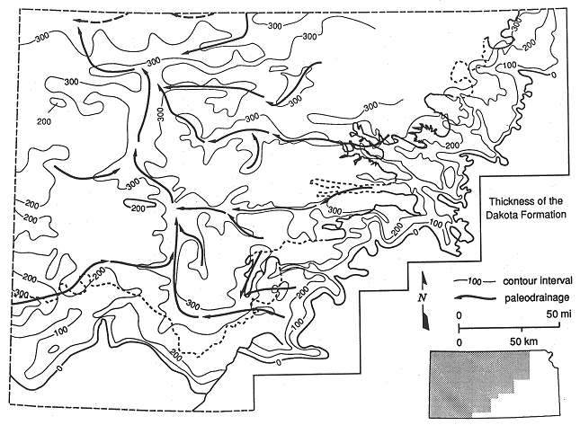
Information on the location of stream valleys and delta systems at the time of deposition is a key element in the prediction of sandstone body trend and distribution and thus, hydraulic continuity. Locally, the more permeable aquifer units consist of sandstones that were deposited in stream valleys and deltas. River and delta distributary channel sandstones differ hydro-stratigraphically from other types of deltaic sandstones in their sandstone body geometry and in their permeability. River and delta distributary channel sandstones tend to be highly permeable, discontinuous, and ribbonlike in contrast to deltaic sandstones which tend to be less permeable, continuous, and sheetlike. These sandstone aquifer units are confined by finer-grained shaley sediments which are much less permeable and act as an aquitard. Figure 6 shows the thickness variation of the Dakota Formation in Kansas and the inferred major river-drainage pattern during the time the sediments that comprise the Dakota aquifer were being deposited (approximately 97 m.y. ago). The Dakota Formation forms upper part of the Dakota aquifer in Kansas.
Figure 6. Regional thickness variations of the Dakota Formation and inferred paleodrainage pattern in Kansas approximately 97 million years ago.
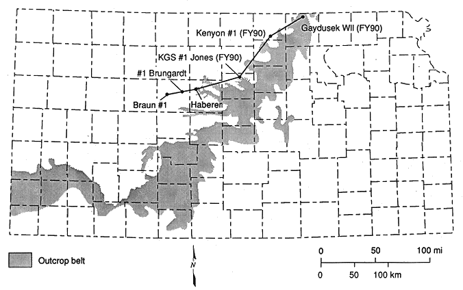
Recent coring and geophysical logging of test holes penetrating the Dakota aquifer in north-central Kansas were undertaken in FY89-90 to assist ongoing research directed at updating our understanding of the stratigraphy of these units. The geologic processes that were responsible for deposition can be interpreted from the architecture of the Dakota aquifer framework. On the basis of these processes it is possible to infer information on the location of major ancient river drainage and delta systems at the time Dakota aquifer sediments were being deposited. These subsurface data were collected from three test holes that were drilled by the Kansas Geological Survey in FY90 in Lincoln, Republic, and Washington counties in order to support regional-scale investigations of the framework Six additional test-holes were drilled through the Dakota aquifer to underlying Permian strata in Washington and Republic counties in order to provide more detailed information on the geologic nature of the aquifer framework in this local area. The results of this work will be reported later in this report.
Three test hole sites were drilled during FY90 in Lincoln, Republic, and Washington counties, north-central Kansas just west of the outcrop belt of the strata that comprise the Dakota aquifer (Figure 7). All of the test holes were cored and logged. Detailed descriptions of each core and the geophysical logging traces can be found in Kansas Geological Survey Open-File Report 91-1a. Each of the test holes was cored using a wire-line coring device that allowed for the continuous collection of 2-in.-diameter core samples of the strata penetrated during drilling. Core recovery was highest in the more consolidated mudstone-rich and cemented sandstone portions of the Dakota aquifer framework and poorest in the sections of poorly cemented to uncemented sandstone. Upon completion of the coring each test hole was logged by Schlumberger, a commercial geophysical logging company, using a diverse combination of tools to provide data on aquifer characteristics and properties.
Figure 7. Geographic location of the FY90 and other test holes in the Dakota aquifer of Kansas
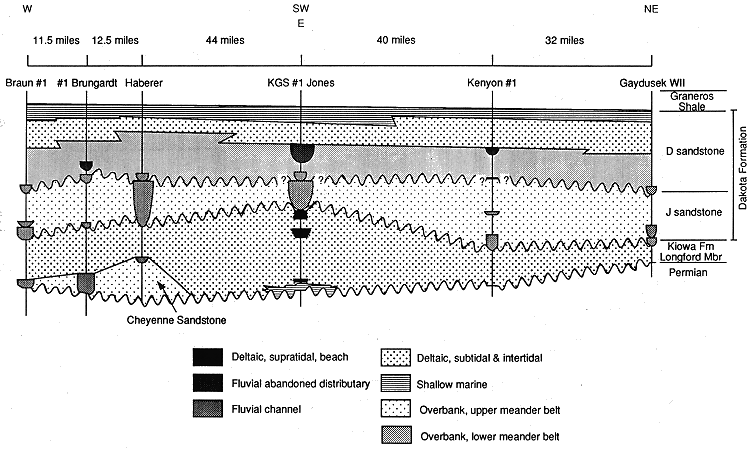
The FY90 test-hole data for the regional investigation along with the results of earlier work have been used to characterize regionally the stratigraphy of the Dakota aquifer framework in central Kansas and to infer the paleogeography of this area at the time these units were being deposited. Figure 8 is a cross-section of the strata that comprise the Dakota aquifer in central Kansas showing the stratigraphy of the Dakota aquifer and the inferred environment of deposition for each interval of the aquifer from cores. The Dakota aquifer in central Kansas is composed of sandstones and mudstones (a lithified mixture of clay and silt) that were deposited in river-channel and floodplain, delta, and shallow marine environments. The strata record two periods of advance of the Cretaceous seas across central Kansas from the west and the development of westward flowing rivers in clearly defined drainage patterns and delta systems. The drainage pattern was probably in part controlled by geologic structure and dissolution of bedded salts in underlying strata and in part by pre-existing erosional topography. Ancient delta systems developed where rivers supplied sediments to an encroaching or stagnant coastline at rates sufficient to keep pace with the rate of sea-level rise or subsidence.
Figure 8. Regional lithofacies variations and stratigraphy of the Dakota Formation, Kiowa Formation, and Cheyenne Sandstone in a cross section through the FY89-90 test holes.
Test-hole Drilling in Washington and Republic Counties, FY90
Figure 9 is a map showing the locations of 8 test holes in Washington and Republic counties that were drilled during FY89-90 by the Kansas Geological Survey. Cores were taken from holes R1 and W2 and these holes were then logged by Schlumberger. The remainder of the test holes were logged by the KGS. All the test holes except W7 were filled with cement after logging to ensure no mixing of waters between different levels of the aquifer and no contamination of the aquifer from the surface. A monitoring well was installed in hole W7. This well was used as the observation well in the pumping test also described in this document. The legal locations of the test holes and lease names are listed in Table 1.
Figure 9. Map showing the locations of 8 test holes drilled by the KGS in FY90 for the Dakota Project in Washington and Republic counties, Kansas.
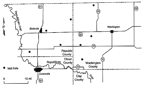
Table 1. Name and location of test holes drilled by the KGS in Republic and Washington counties during FY89-90.
| Hole Number* | Lease Name | Location |
|---|---|---|
| R1 | Kenyon | Sec. 24, T. 4 S., R. 4 W. |
| W2 | Gaydusek | Sec. 10, T. 1 S., R. 2 E. |
| R3 | Popelka | Sec. 6, T. 3 S., R. 2 W. |
| W4 | Peterson | Sec. 10, T. 4 S., R. 1 E. |
| R5 | Benyshek | Sec. 12, T. 4 S., R. 2 W. |
| R6 | Cromwell | Sec. 12, T. 2 S., R. 1 W. |
| W7 | Leiszler | Sec. 10, T. 5 S., R. 1 E. |
| W8 | Nanninga | Sec. 16, T. 3 S., R. 2 E. |
The cores and logs from R1 and W2 were used to determine the detailed characteristics of the geologic framework of the aquifer and to infer its environments of deposition, discussed earlier in the Central Kansas Coring and Stratigraphic Analysis section. Knowledge of depositional environment is useful in correlating sequences of rocks between test holes. The rest of the holes were drilled rather than cored; samples were taken every 5 ft and the holes were then logged using USGS geophysical logging tools to determine the exact depth of changes in rock types. Sequences of rock types discovered in R1 and W2 were recognized and correlated to sequences in the other holes.
From the test-hole drilling in Washington and Republic counties, we have drawn the following conclusions. First, the uppermost 65-90 ft of the aquifer was deposited in a deltaic environment similar in many ways to the Mississippi delta. Sandstones in this part of the aquifer are therefore generally very fine grained and quite muddy. In addition, they are usually not very thick. They are therefore unlikely to yield enough water for irrigation purposes. They yield sufficient water for domestic and stock wells where the water quality is adequate for these uses.
Second, fluvial sandstones of the Dakota Formation are generally coarser grained, better sorted, and less muddy and occur in the lower part. They were deposited in river channels which are generally higher-energy environments than those in deltas. The sandstone at the base of these deposits is typically the coarsest in the aquifer and the permeability and porosity are usually the highest in these coarser sandstones. Where these fluvial sandstones are thick well yields of several hundred gallons per minute are possible. The well installed in W7 is on the edge a cluster of irrigation wells in thick basal Dakota sandstone. Another cluster of high-yield wells north of the town of Washington is also drawing water from the basal sandstone. The hydraulic connection between sandstones higher up in the Dakota Formation is questionable. For example, a highly permeable sandstone in the middle of the aquifer in W2 is not present 11 miles away in R6.
Third, the base of the Dakota Formation rests either on top of the Kiowa Formation or on Permian shales and is variable in thickness. The Kiowa Formation is not present in test holes W4, W7 and W8, in western and southwestern Washington County, nor is it present in eastern Washington County, where the Dakota Formation outcrops and the aquifer thins. Elsewhere in the area of test hole drilling, this sequence of moderately permeable interbedded sandstone and mudstone comprises the base of the Dakota aquifer. However, wherever it is present it is not significant as a water resource due to its considerable depth and the likelihood that the water it contains is saline. The Dakota aquifer as a whole thickens slightly to the west because of the westward thickening of the Kiowa Formation.
Expansion of the Geologic Data Base in South-central and Southwestern Kansas
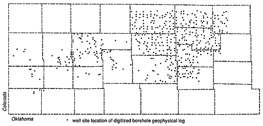
To develop sufficient detail on the nature of the geologic framework and the subsurface geologic structures of the southwestern and south-central Kansas subareas, the geologic data base for those subareas is being expanded considerably by increasing the density of control points. This has required adding more data from geophysical logs of oil and gas wells in the area to the existing data base developed in FY89. In FY89 a geophysical log data base made up of the digitized natural gamma-ray log of selected sites was developed to facilitate the future needs of the program and provide information that could be made easily available to other agencies. The natural gamma ray log of oil and gas wells and of other types of boreholes were selected for digitizing at a density of one per township, where available in the Mineral Information well-log collection maintained by the Kansas Geological Survey. The gamma ray log can be used to discriminate different rock types penetrated by the bore hole, if the interpreter has some experience in the geology of the area. The resulting data base is described in the FY89 Dakota aquifer program annual report. This data base was used extensively during the FY89 investigation of the Dakota aquifer to regionally characterize the Dakota aquifer framework, and the shallow subsurface geology of western and central Kansas. In FY90 the sampling density has been increased to the point where all of the available API-calibrated natural gamma ray logs (a total of 493 logs; 813,000 total ft. digitized) have been added to the data base for most of south-central and south-western Kansas (T. 17-31 S., R. 14-41 W.) (Figure 10). With the completion of the digitizing effort late in FY90, the data are being used to support ongoing efforts to develop more detailed information concerning (1) the shallow subsurface geology that includes the Dakota aquifer framework, (2) the distribution and trends of sandstone aquifers, and (3) the definition of hydrostratigraphic units in T. 17-31 S., R. 14-41 W.
Figure 10. Distribution of bore-hole geophysical logs added to the data base during FY90.
Development of a southeastern Colorado Geologic Data Base
With the expansion of the southwestern Kansas subregional study area into southeastern Colorado there is a need for the development of a geologic data base for this additional area. Therefore, API-calibrated natural gamma-ray logs of oil and gas wells in the southeastern Colorado area (T. 23-35 S., R. 41-45 W.) were selected, where available in the Mineral Information well-log collection maintained by the Kansas Geological Survey. These logs have not been digitized since the log coverage is sparse and only the formation top data is of interest.
Previous page--Regional Setting ||
Next page--Geohydrology
Start of this report ||
Table of Contents