


Kansas Geological Survey, Open-File Rept. 91-1
Annual Report, FY 90--Page 3 of 9
Regional Setting
The Dakota aquifer consists of interbedded sandstones and shales that
were deposited in river valleys, in deltas, and in nearshore marine
environments during the early part of the Cretaceous Period (108 to 94
million years ago, approximately) (Figure 3). The aquifer can be
subdivided regionally into upper and lower aquifer units separated by a
less permeable aquitard of shale that is present over much of area
(Figure 4). The ability to transmit water laterally through the upper
and lower aquifers depends on the hydraulic continuity of the framework
which is directly related to the proportion of sandstone and shale.
Vertical movement of water between aquifer units depends on the
hydraulic connection of sandstone aquifers, including fractures that
penetrate the shale. Well yields vary widely in the system and are
controlled by the thickness and hydraulic properties of the sandstone
units. The aquifer is unconfined or partially confined in central
Kansas and widely separated areas of southwestern Kansas-southeastern
Colorado and is confined where covered by younger less permeable strata
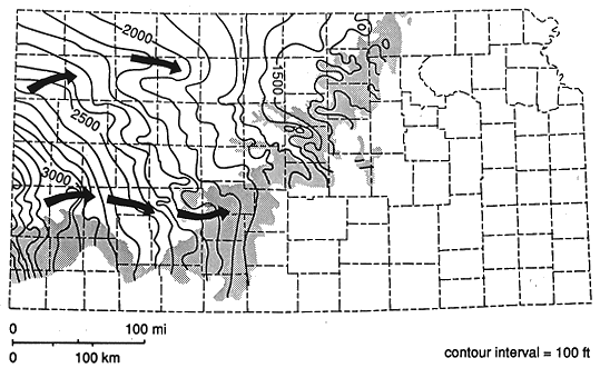
elsewhere. The main pattern of ground-water flow in the Dakota aquifer
is from recharge areas in southeastern Colorado and southwest Kansas to
discharge areas in central and north-central Kansas river valleys
(Figures 4 and 5). The Dakota aquifer is recharged by precipitation in
the outcrop area, by the overlying water-table aquifer in southwest
Kansas, and by the underlying Cedar Hills aquifer where both aquifers
are hydraulically connected in the central part of the state.
Figure 3. Midcontinent geography during deposition of the middle
portion of the Dakota aquifer approximately 97 million years ago.
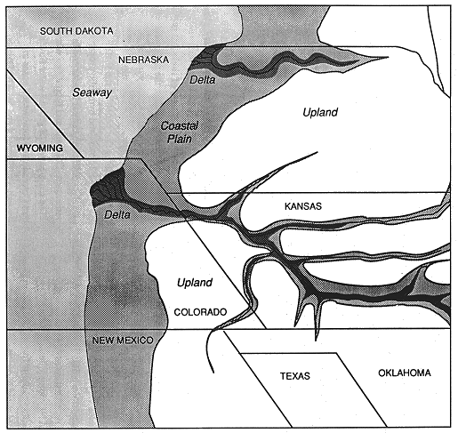
Figure 4. Distribution of hydraulic head and ground-water flow
direction in a cross-section of the shallow subsurface, including the
Dakota aquifer, extending from southwestern into central Kansas.
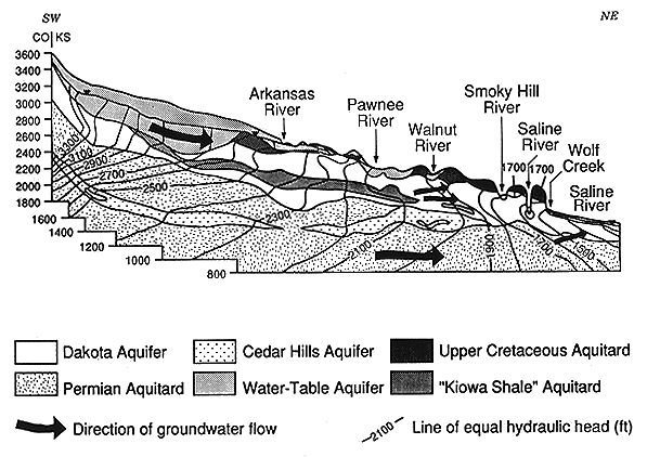
Figure 5. Configuration of the pre-development potentiometric
and water-table surfaces of the upper part of the Dakota aquifer in
Kansas.
The Dakota aquifer is used widely for irrigation, public water supply,
and industry in southwestern and central Kansas and southeastern
Colorado. In Kansas approximately 96% of the current volume withdrawn
occurs in southwest and south-central parts of the state. Water-level
declines in observation wells have become appreciable in southwestern
Kansas and adjacent areas as development of the High Plains and Dakota
aquifers continues.
Freshwaters occur along the eastern outcrop area, part of the eastern
subcrop adjacent to the outcrop zone, and in the subcrop area of the
Dakota aquifer in southwestern Kansas. The rates of change in
dissolved-solids contents with areal distance are greatest along the
easternmost subcrop from Republic County to Barton County. Saltwater in
the Dakota aquifer in central Kansas is geochemically identified as
derived primarily from solution of halite (rock salt) in Permian rocks,
and has flowed upward into the Dakota. The upward movement from the
Permian is affected by pinching out of confining layers and the presence
of fractures and other geologic structures.
Previous page--Introduction ||
Next page--Geologic Framework
Start of this report ||
Table of Contents
Kansas Geological Survey, Dakota Aquifer Program
Original report available from the Kansas Geological Survey.
Electronic version placed online Nov. 1998
Scientific comments to P. Allen Macfarlane
Web comments to webadmin@kgs.ku.edu
URL=http://www.kgs.ku.edu/Dakota/vol3/fy90/rep03.htm