Kansas Geological Survey, Open-File Rept. 90-27
Annual Report, FY89--Page 6 of 10
This chapter is divided into three parts: 1) a description of the formations that make up the Dakota aquifer, 2) a comparison with Colorado stratigraphy, where detailed sequence stratigraphy has been deomonstrated to improve predictions about fluid flow, and 3) a description of the sequence stratigraphy in Kansas that was done for this study. Plates 3,4,5 and 6 show the altitude of the Dakota Formation top the thickness of the Dakota Formation, the altitude of the Kiowa Formation top, and the combined thickness of the Dakota Formation, Kiowa Formation, and Cheyenne Sandstone in Kansas, respectively. Plates 7 and 8 show the altitude of the Morrison Formation top and thickness of the Morrison Formation in Kansas, respectively. Plates 9, 10 and 11 show the altitude of the Permian top, the altitude of the Cedar Hills Sandstone and the thickness of the Cedar Hills Sandstone in Kansas, respectively.
Sequences divide the stratigraphic record into genetically related, time-bounded stratigraphic units. By placing facies within this time-space framework, it is possible to determine how depositional environments shifted through time and space. From this framework the spatial distribution and interconnections of lithologies of varying hydraulic conductivities can be found and hydrostratigraphic units identified. A hydrostratigraphic unit is defined as a formation, portion of a formation, or group of formations which have similar hydrologic properties and can be grouped into aquifers, aquitards, or aquicludes (Maxey, 1964). This information can be used to understand regional ground-water flow, determine quantity and quality of ground water available for future use and aid in the assessment of anthropogenic effects on the regional ground-water-flow system.
Sequence-stratigraphic relations of these Cretaceous strata can be established by identifying unconformities through facies analysis and consequent recognition of seaward shifts of facies tracts. By applying this procedure, using outcrop, core, and well-log data, at multiple localities across Kansas, the positions of regionally significant unconformities can be described. These unconformities constitute time-significant boundaries that separate strata into sequences which are independent of facies variations or established lithostratigraphic units. Because these unconformity-bounded sequences are regionally extensive and represent the products of sea-level fluctuation, tectonic movement and variations in sediment supply, they should correlate with sequences recognized in Colorado. They also should possess some of the internal stratigraphic architecture and facies variations described in time-equivalent sequences along the western margin of the Cretaceous seaway. However, because subsidence and sediment supply rates were far less in Kansas than in Colorado, Utah and Wyoming, some differences in the internal characteristics of sequences are expected. Description and analysis of these differences may prove generically applicable. That is, comparison of the stratal geometries and facies distributions within identical sequences deposited under markedly different conditions of subsidence and sediment-supply rates may provide a data base from which the sedimentologic effects of these interdependent controls may be assessed.
In order to establish the regional stratigraphic framework, two major questions need to be addressed: a. How do subsurface strata in Kansas correlate with strata in Colorado,? and b. What is the correlation of subsurface to surface strata in Kansas? The purpose of this chapter is to establish the sequence-stratigraphic relations of Upper and Lower Cretaceous (Albian and early Cenomanian) strata in Kansas and correlate these with sequences of similar age defined by Weimer (1984) in Colorado. Following the discussion of regional stratigraphy, the focus will shift to determining sequences within the Cretaceous strata below the Greenhorn Limestone.
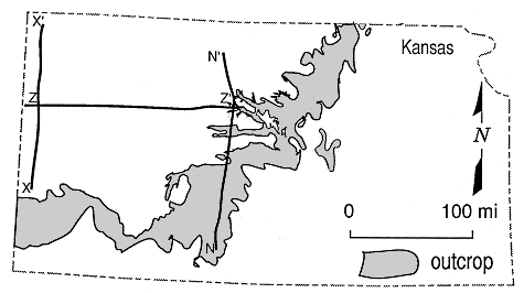
Figure 7.1. Map showing outcrop and subcrop trace of Dakota aquifer and location of cross sections in Figures 7.3, 7.4, and 7.5.
Cretaceous strata in Kansas are divided into lithostratigraphic units, rather than into time-significant, unconformity-bounded stratigraphic sequences. By contrast, owing to more recent and extensive studies in the Denver basin, time-equivalent Cretaceous strata in Colorado have been interpreted within a sequence-stratigraphic framework (Weimer, 1984). Because of these different philosophical approaches, this discussion on the stratigraphic framework is organized into three sections. The first treats stratigraphic nomenclature, age relations, lithologies and inferred depositional environments for strata in Kansas. The second section addresses the sequences and their lithologic components in Colorado. The third section discusses the differences and problems of correlation between Kansas and Colorado.
Cretaceous strata of this study in Kansas include the Cheyenne Sandstone, Kiowa Formation, Dakota Formation, and Graneros Shale (Figure 7.2). These are unconformable on the Jurassic Morrison Formation in most of the subsurface. East and south of the Morrison Formation subcrop, Cretaceous strata rest with angular unconformity on Permian strata in the subsurface and outcrop. Plates 3, 4, 5 and 6 show the altitude of the Dakota Formation top, the thickness of the Dakota Formation, the altitude of the Kiowa Formation top and the combined thickness of the Dakota Formation, Kiowa Formation and Cheyenne Sandstone in Kansas, respectively.
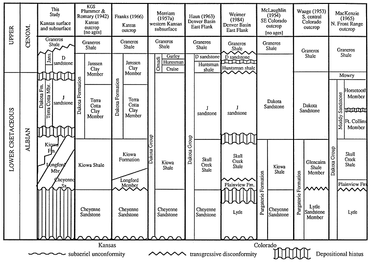
Figure 7.2 Stratigraphic-nomenclature chart showing correlations between formation names based on their position with respect to the Upper/Lower Cretaceous boundary.
Cheyenne Sandstone
The Cheyenne Sandstone was first described by Cragin in 1895 and named by Cragin (1889) after Cheyenne Rock at the type section near the town of Belvidere in southeast Kiowa County, Kansas. Cragin (1889) assigned the Cheyenne to the Comanchean Series. Because it lacks marine fossils, its age is constrained as older than the overlying Kiowa Formation which is Upper Albian (Scott, 1970). Early interpretations of the Cheyenne suggested that it was deposited in a fluviatile coastal plain near the strandline of the northward-advancing Cretaceous sea (Twenhofel, 1924; Plummer and Romary, 1942; Scott, 1970).
The Cheyenne Sandstone is unconformable upon either Permian strata or the Jurassic Morrison Formation in both the outcrop and subsurface (Twenhofel, 1924; Swineford and Williams, 1945; Merriam, 1957a). The unconformity on the Permian has as much as 50 ft of relief locally (Plummer and Romary, 1942). The contact with the overlying Kiowa Formation has been reported as both conformable (Latta, 1946; Scott, 1970) and unconformable (Franks, 1975).
In outcrop the Cheyenne Sandstone consists predominantly of light-colored, fine- to medium-grained, friable crossbedded sandstone. Lenses of conglomerate, and sandy to silty carbonaceous shale containing lignite and plant fossils are also common in the upper part of the formation (Latta, 1946). Exposures of the Cheyenne Sandstone occur only in southern Kansas in areas near the type section. Fent (1950) reported inliers of a sandstone and a cobble zone at the base of the Kiowa Formation in Rice County which he thought may be Cheyenne Sandstone. The thickness of the formation in outcrop ranges from 32 ft to 94 ft (Latta, 1946). However, because of lithologic variations and absence of fossils in the Cheyenne, its presence and thickness have been variously interpreted in both outcrops and in the subsurface.
In the subsurface the Cheyenne is commonly described as white, fine- to medium-grained sandstone composed of subrounded, frosted quartz grains that are unconsolidated or cemented with pyrite or calcium carbonate (Merriam, 1957a). Swineford and Williams (1945) identified two types of mineralogy, Permian-like and Kiowa-like, within the Cheyenne, and noted thickness variations ranging from 0 to 62 ft in Russell County of central Kansas. Frye and Brazil (1943) reported 0 to 200 ft in Russell and Ellis Counties. Merriam (1957a) identified the Cheyenne throughout the Kansas subsurface and recorded a maximum thickness of 260 ft. He also noted that the thickness is variable and that the formation thins to the east and south. Scott (1970) reported the Cheyenne Sandstone as absent in the central Kansas subsurface.
Kiowa Formation
The Kiowa Formation was first described by Cragin in 1889 and was named by Cragin (1895) as the Kiowa Shale at the type section near Belvidere, Kiowa County, Kansas. It was defined by Plummer and Romary (1942) as marine shale, sandstone and fossiliferous limestone above the Cheyenne Sandstone and below the Dakota Formation. The top of the formation was more specifically defined by Franks (1966) as occurring at the base of the red-mottled mudstones and claystones of the Dakota Formation.
The Kiowa Formation is exposed throughout the entire outcrop belt and subsurface, except in the northeast part of the state where it pinches out beneath the Dakota Formation in Ottawa and Clay counties (Plummer and Romary, 1942). The Kiowa Formation rests on Cheyenne Sandstone and Permian strata in outcrop (Scott, 1970). The contact with the Permian is an angular unconformity with commonly 50 ft, and sometimes 100 ft, of relief (Franks, 1966). The contact with the Cheyenne Sandstone is reported as both conformable (Latta, 1946) and unconformable (Franks, 1975). Twenhofel (1924) described the contact as, "The Kiowa shales rest unconformably on the Cheyenne Sandstone. The contact is sharply defined and abrupt and is thought to represent the change from continental to marine conditions. The plane of contact is the strandline surface of erosion made by the transgressing sea." The contact with the overlying Dakota Formation is reported as conformable and gradational (Latta, 1946), and conformable and disconformable (Latta, 1948; Franks, 1979).
The lithology of the Kiowa Formation is variable as reported by different authors, and includes shale, thin sandstone and fossiliferous limestone. It has a thickness of 300 ft in the type area (Latta, 1946). In the subsurface of Russell and Ellis counties, it is between 100 and 125 ft thick (Frye and Brazil, 1943), and Merriam (1957a) reported a maximum thickness of 380 ft in the subsurface of western Kansas. Depositional environments of the Kiowa Formation have been interpreted as sublittoral to open marine (Scott, 1970), reflecting the variability in lithologies. Sandstones within the formation are interpreted as delta-front sands, barrier bars, offshore bars, and tidal-current bars deposited near the margin of the Kiowa sea (Franks, 1966, 1975). The age of the formation is Upper Albian, Venezoliceras kiowanum to Inoceramus bellvuensis zones (Scott, 1970). It is reported as the lithologic and temporal equivalent of the Skull Creek Shale of eastern Colorado (Cobban and Reeside, 1952; Haun, 1963).
Longford Member of the Kiowa Formation. Franks (1966) separated white siltstones, lenticular sandstones and red-mottled siltstones and mudstones at the base of the Kiowa Formation into the Longford Member. Subsequently he determined that the Longford Member rests with transgressive disconformity on the Permian and is conformably overlain by the Kiowa Formation (Franks, 1980).
The Longford Member outcrops in a north-south-trending band at the base of the Kiowa Formation along the eastern edge of the outcrop belt in central Kansas, where it is up to 100 ft thick (Franks, 1979). It is not present in southern Kansas outcrops, but similar lithologies at the base of the Kiowa Formation have been reported in the subsurface of Barton County (Latta, 1950). Franks (1980) interpreted the Longford Member as a variety of nonmarine and paralic deposits including fluvial, estuarine, lagoonal, and barrier bars.
Dakota Formation
The Dakota Formation was first described by Meek and Hayden (1861) near Dakota City in northeastern Nebraska. In Kansas the formation is defined as nonmarine and littoral clay and sandstone over the Kiowa Formation and below the Graneros Shale and consists of the Terra Cotta Clay and Janssen Clay members (Plummer and Romary, 1942). The type sections for both members are located in Ellsworth County in central Kansas. The Dakota Formation is Albian to Cenomanian age (Franks, 1975), and the upper part is restricted to the Cenomanian (Hattin, 1965; Franks, 1966). The average thickness of the formation is 250 ft (Siemers, 1971). In Ellis and Russell counties the thickness is between 200 and 300 ft (Frye and Brazil, 1943). Mack (1962) reported a thickness of 350 ft in Ottawa County. Thickness of Dakota Formation exceeding 350 ft occur in several areas of western Kansas (Plate 4).
The lithology of the Dakota Formation is highly variable. The upper part generally consists of variegated nonmarine claystone, fluvial sandstone, estuarine sandstone, lignite and shale. The lower part consists of white, gray, brown, red, and tan mudstone, with claystone, siltstone, and sandstone lenses. Sandstones in the formation are dominantly quartz rich (Siemers, 1971), fine- to medium-grained and comprise 25% to 40% of the formation (Mack, 1962). Conglomeratic sandstones are common at the base of the formation (Franks, 1966), and multistory fluvial channel sandstones up to 70 ft thick have been described in outcrop (Franks, 1975). The source of the sediment is to the east and northeast (Franks, 1966).
Depositional environments represented by these lithologic types are mostly nonmarine in central Kansas outcrops. Merriam et al. (1959) interpreted dominantly marine depositional environments in a core from western Kansas. Franks (1966, 1975) interpreted the Dakota Formation as alluvial plain and deltaic complexes deposited during the retreat of the Kiowa Sea. Plummer and Romary (1942) interpreted sandstones in the formation as nearshore sand flat deposits, and claystones as lagoon, swamp, lake, stagnant stream, or delta deposits in a setting similar to the Mississippi delta.
The Rocktown Channel Sandstone is a prominent sandstone body in the upper part of the formation in outcrops of Russell County. It was deposited by meandering streams in a wide floodplain where variegated and carbonaceous mudstones were also deposited (Rubey and Bass, 1925). The uppermost part of the formation in Russell County was deposited in distributary channels, estuaries, and deltas (Siemers, 1976).
The contact between the Dakota Formation and the underlying Kiowa Formation has been described as conformable, disconformable and unconformable (Plate 5). Unconformable contacts are generally described as erosional surfaces separating gray, massive clay from overlying red, yellow and red-mottled clay with concretionary iron pellets (Plummer and Romary, 1942). Mack (1962) described an erosional, unconformable contact in Ottawa County where channels in the Kiowa Formation are filled with sandstones of the Dakota Formation. By contrast, the contact in southern Kansas was described by Latta (1946) as occurring within a lithologically homogeneous stratigraphic succession, and therefore interpreted as conformable and gradational. However, Latta (1948b) later described the same contact as conformable but locally unconformable. Franks (1966) interpreted the contact in the south-central Kansas outcrops as conformable on regressive deposits of the Kiowa Formation, and unconformable where the Dakota is locally scoured into the Kiowa Formation. Franks (1975) interpreted the contact in the north-central Kansas outcrops as a transgressive disconformity, but suggested that the Dakota Formation intertongues to the west with (passes laterally into) the Kiowa Formation. Merriam (1957a) also suggested that the two formations intertongued locally but not regionally.
Terra Cotta Clay Member. The Terra Cotta Clay Member is defined as gray claystone and red-mottled massive claystone, siltstone, and sandstone comprising approximately the lower two-thirds of the Dakota Formation (Plummer and Romary, 1942). Thickness of the member ranges from 150 ft to 250 ft (Franks, 1966).
According to Karl (1976), sandstones in Washington County, Kansas, and southern Nebraska were deposited by low sinuosity bedload streams flowing southwest. The fine-grained facies of this member were deposited in floodplains adjacent to these rivers (Franks, 1975).
The contact with the overlying Janssen Clay Member is gradational and is placed at the top of a concretionary siderite, limonite, or hematite, and/or "quartzite" sandstone which is overlain by a bed of gray, massive clay (Plummer and Romary, 1942). In Russell County, Rubey and Bass (1925) described the gray shale at the top of the Dakota Formation as grading downward and laterally with variegated mudstone. They also recognized that the locally occurring Rocktown channel sandstone in the upper 125 ft of the formation interfingers with and cuts into variegated shale.
Janssen Clay Member. The Janssen Clay Member is defined as lignite, dominantly kaolinitic grey to dark-grey massive claystone, siltstone and some shale above the Terra Cotta Clay Member and below the Graneros Shale (Plummer and Romary, 1942). Other rock types include isolated lignites 2 ft to 28 ft thick, ironstone-bearing or sideritic claystones up to 31 ft thick (Siemers, 1971), and fine-grained, trough and epsilon cross-stratified, lens-shaped sandstones (Karl, 1976).
The Janssen Clay Member constitutes approximately the upper one-third of the Dakota Formation. It varies between 30 ft to 80 ft thick according to Plummer and Romary (1942), and 50 ft to 100 ft according to Franks (1966).
The environment of deposition is largely transitional from nonmarine to marine. Sandstone lenses were deposited in meandering streams (Karl, 1976). Flat-bedded sandstones were deposited in estuaries and deltas, lignites in fresh to brackish water swamps, and iron-bearing claystones in brackish and open marine bays (Siemers, 1971).
The Dakota Formation is described as grading laterally into and intertonguing with the Graneros Shale. Franks (1966, 1975) and (Siemers, 1971) characterized the contact as uneven and transitional. Hattin (1965) also recognized that the Dakota-Graneros contact is transitional through alternating beds of sandy shale, shale and thin sandstone beds. He suggested that the Graneros Shale intertongues with the Dakota.
Graneros Shale
The Upper Cretaceous Graneros Shale is defined in central Kansas outcrop as consisting in the lower part of medium dark-grey, noncalcareous, silty and sandy shale with numerous sandstone beds, and in the upper part of medium dark-grey silty shale with calcareous sandstone and beds of Inoceramus prisms (Hattin, 1965). The lower part of the formation was deposited in shallow nearshore marine water of less than normal salinity. The upper part of the formation was deposited in offshore marine water of normal salinity (Hattin, 1965). The Graneros Shale is 25 ft to 40 ft thick in Ellis and Russell Counties (Frye and Brazil, 1943), 24 ft to 40 ft thick in central Kansas outcrop (Hattin, 1965), and 14 ft to 40 ft thick in Russell County (Swineford and Williams, 1945).
Weimer (1984) proposed a division of Cretaceous strata into sequences of genetically related strata bound by time-significant surfaces of subaerial unconformity and their correlative conformities. These unconformities were formed by subaerial erosion during times of lowered sea level and were enhanced by local and regional tectonics. The unconformities are interregional in extent and are recognized by incised valleys, missing facies, root zones and paleosols associated with scour surfaces. Four unconformity-bound sequences defined by Weimer (1984) encompass the time during which strata of this study were deposited in Kansas.
Depositional environments across (east-west) the seaway varied as a consequence of differential depositional slopes and subsidence rates. Since Colorado was in a more seaward position and closer to the Sevier thrust belt, marine depositional environments were dominant and subsidence rates greater. Fluvial depositional environments were dominant in the landward direction in Kansas. Merriam et al. (1959) observed that a core from the Dakota Formation in northwest Kansas was much more marine in character than outcrops to the east in central Kansas.
Source areas of sediments were mainly from the western and eastern margins of the Western Interior basin (Figure 6.6). Sediments in Kansas were transported from the east and northeast, and some were derived locally (Swineford and Williams, 1945; MacKenzie and Poole, 1962; Franks, 1966). Strata in Colorado were transported from the west and east, with the mineralogical suites interfingering in the central part of the basin in eastern Colorado. The D sandstone of the upper Dakota Group was derived entirely from the northeast (MacKenzie and Poole, 1962).
Basal Cretaceous strata of eastern Colorado and western Kansas subsurface are unconformable on the Jurassic Morrison Formation. Elsewhere in Kansas, they are unconformable on Permian strata of the Custerian and Cimmaronian stages (Merriam, 1963).
The Cheyenne Sandstone outcrops only in southwest Kansas and is not present everywhere in the subsurface. In Colorado, the Cheyenne is recognized on the east flank of the Denver basin, and the Lytle Formation is recognized as the basal Cretaceous unit along the Front Range. The Kiowa Formation is present everywhere in the subsurface and outcrop of Kansas except in north-central Kansas where it pinches out to the east beneath the Dakota Formation. In Colorado, the Skull Creek Shale is recognized across the Denver basin through the Front Range. Formations of the Dakota Group are present everywhere in eastern Colorado outcrop and subsurface with the exception of the D sandstone. The D sandstone, derived from the east, reaches its depositional limit east of the outcrop. The Dakota Formation of Kansas and its equivalents in eastern Colorado are everywhere overlain by the Graneros Shale.
Correlations of the Lytle Formation to the Cheyenne Sandstone, and the upper Dakota Group to the Dakota Formation between Colorado and Kansas are problematic. This is largely due to the absence of fossils in these units and to the gross lithologic similarities of these pairs of formations which have caused them to be treated as temporal equivalents. By contrast, the Kiowa Formation, Skull Creek and Glencairn Shales have been correlated by lithologic and faunal equivalence throughout the Western Interior basin (Cobban and Reeside, 1952; Haun, 1963; Scott, 1970). These formations provide a physically correlative stratigraphic separation between the lower and upper formations of the Dakota Group in Colorado, and between the Cheyenne Sandstone and Dakota Formation in Kansas.
The Cheyenne Sandstone was first described by Cragin (1889) in south-central Kansas. It was correlated on the basis of lithologic similarity by McLaughlin (1954) to the Lytle Formation of the Dakota Group in south-eastern and south-central Colorado outcrop. There are no fossils in either the Lytle Formation or Cheyenne Sandstone, and a physical correlation of the two formations is not possible because the Cheyenne Sandstone pinches out west of its outcrop in Kansas. Haun (1959) demonstrated that the Lytle Formation is physically continuous from the Colorado outcrop into the subsurface of the Denver basin where it is called the Cheyenne Sandstone. The Cheyenne Sandstone in the Colorado subsurface is assumed the temporal equivalent of the Cheyenne Sandstone of Kansas outcrop (Haun, 1963).
Scott (1970) correlated the Lytle Formation in Colorado with the Cheyenne Sandstone in Kansas based on an assumed conformable relationship with the overlying Glencairn Shale and Kiowa Formation, respectively. Scott (1970), following previous workers, interpreted the Cheyenne Sandstone of Kansas as coastal plain deposits adjacent to the transgressing Kiowa sea. From this interpretation, Scott (1970) recognized that the Cheyenne Sandstone is temporally equivalent to the marine shales of the Kiowa. He also assumed an identical relationship between the Lytle Formation and Glencairn Shale of Colorado. This assumed correlation between the Cheyenne Sandstone and Lytle Formation may be incorrect. Weimer (1984) recognized an unconformity at the top of the Lytle Formation, separating it from the Plainview Formation and Glencairn and Skull Creek Shales. Weimer (1984) extended this observation into the subsurface and recognized an interregional unconformity between the Lytle and Plainview Formations and their temporal stratigraphic equivalents. So the Kiowa sits conformably on a sandstone that is younger than the Lytle. Therefore, the Cheyenne Sandstone of Colorado subsurface is probably not correlative to the Cheyenne Sandstone of Kansas outcrop. The significance of these possibilities will be addressed subsequently.
Merriam (1957a) suggested tentative correlations of the Dakota Formation in Kansas with strata in the Colorado and Nebraska portions of the Denver basin. He correlated the Dakota Formation in Kansas with the Omadi Formation of Condra and Reed (1943) in Nebraska. The three members of the Omadi Formation, the Cruise Sandstone, Huntsman Shale and Gurley Sandstone, were correlated to the J sandstone, Huntsman Shale, and D sandstone, respectively. He also correlated the J sandstone to the Janssen Clay Member of the Kansas outcrop, and suggested that there were no stratigraphic equivalents to the D sandstone in the Kansas outcrop. Merriam (1957a) placed the Upper/Lower Cretaceous boundary at the base of the Omadi Formation.
Haun (1963) proposed corrections to the correlations by Merriam (1957a). Haun (1963) mapped the zero isopach of the Huntsman Shale almost coincident with the Colorado-Kansas state line. This is in direct contradiction to the correlation of the Huntsman Shale throughout the Kansas subsurface by Merriam (1957a). Haun (1963) placed the Upper/Lower Cretaceous boundary at the top of the Omadi Formation.
These contradictions, along with the speculative correlations of the Dakota Formation members into the subsurface, are major hindrances to the correlation of Kansas outcrop with Denver basin strata. However, Weimer (1984) made correlations from Wyoming to western Kansas by classifying formations and members as genetically related parts of unconformity-bound sequences. Weimer (1984) correlated the Dakota Formation of western Kansas to the J sandstone, Huntsman Shale, and D sandstone of Colorado. Weimer (1984) indicated that the Huntsman Shale is not present in Kansas, and that the J and D sandstones are merged as the Dakota Formation of Kansas. He placed the Upper/Lower Cretaceous boundary at the top of the J sandstone in Colorado. From his correlations this would place the Upper/Lower Cretaceous boundary somewhere in the middle of the Dakota Formation in Kansas. The obscurity of this unconformity, and hence time boundary, within the Dakota Formation continues to make correlations of outcropping Dakota Formation members with Denver basin strata tentative.
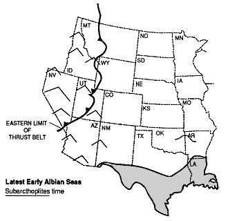
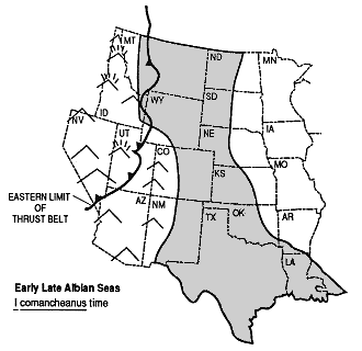
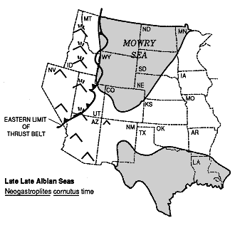
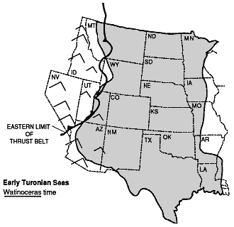
Figure 7.3. Maps showing speculated extents of continental seaways at different times during the Cretaceous.
Large-scale variations in relative sea level, on the order of 3 to 5 million year periods, formed unconformity-bounded depositional sequences. For the Western Interior Cretaceous basin these interregional surfaces were formed during relative sea level falls and lowstands. During lowstands, deposition was restricted to the basin center and the eastern and western margins were subaerially exposed. Sources of sediment were from the east and west and from the Transcontinental arch. Valleys formed by erosion during lowstands were filled by sediment during subsequent relative rise in sea level. A stratigraphic sequence for this study follows the definition of Weimer (1984) as a package of genetically related strata bound by subaerial erosional unconformities.
Weimer (1984) defined several sequences in Cretaceous strata in Front Range outcrops and in the western Denver basin subsurface. The basal sequence rests unconformably on Jurassic strata, and consists entirely of the Lytle Formation. The second sequence extends from the unconformity at the base of the Plainview Formation (top of the Lytle Formation) to the top of the Fort Collins Member of the Muddy Sandstone (J 3 unit of the J sandstone), and includes the intervening Skull Creek Shale. The third sequence extends from the unconformity at the base of the Horsetooth Member of the Muddy Sandstone (J 2 unit of the J sandstone) to the base of Codell Sandstone. An erosional unconformity occurs at the base of the D sandstone in the eastern part of the Denver basin but is not present in the western Denver basin or Front Range outcrop. The D sandstone was derived from the eastern side of the basin (MacKenzie and Poole, 1962), and its basal unconformity has not been recognized west of its depositional limit in Colorado. Where the D sandstone is present, its basal unconformity forms the upper boundary of the third sequence, and a fourth sequence is contained between it and the unconformity at the base of the Codell Sandstone.
In this study, sequences in Kansas were identified first in the western part of Kansas along the Colorado border, closest to areas in Colorado where Cretaceous sequences have been identified previously. Since Cretaceous strata in western Kansas were deposited in a more basinward position than strata in the rest of the state, they have more marine components in which evidence of subaerial exposure and facies shifts are more readily identified.
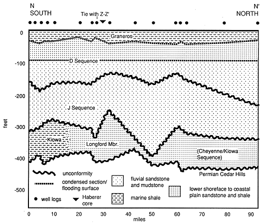
The stratigraphic sequences and facies were calibrated to gamma ray well log signatures. Sequences were correlated on three statewide well-log cross sections and then correlated with sequences defined by facies analysis of 13 measured sections. Lateral and vertical relations of the sequences and formations are discussed with reference to diagrams constructed from these well-log cross sections (Figure 7.1, 7.4, 7.5 and 7.6). The south to north cross section X-X' was hung on the top of the Dakota Formation. The "X" bentonite is contained in the upper part of the Graneros Shale and is approximately parallel to the contact with the overlying Greenhorn Limestone. Since the Graneros is roughly the same thickness across the section, the top of the Dakota approximates a time surface. The west to east Z-Z' cross section was hung on the top of the Graneros. The south to north N-N' cross section was constructed approximately parallel to outcrop in central Kansas. The southern well logs of this section are located in outcrops of Cheyenne and Kiowa Formations.
Figure 7.4. Stratigraphic cross section X-X' showing formations, sequences, progradational events within sequences and facies distributions. Datum is top of Dakota Formation.
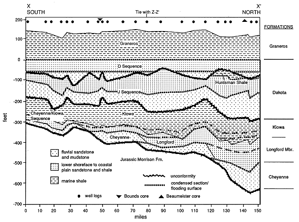
Figure 7.5. Stratigraphic cross section Z-Z' showing formations, sequences, progradational events within the upper sequence and facies distributions. Datum is top of Graneros Shale.
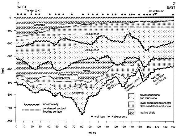
Figure 7.6. Stratigraphic cross section N-N' showing formations, sequences, and facies distributions. Note lateral facies equivalence of Longford Member with Kiowa Shale. Datum is top of Graneros.
In Kansas, four sequences of Weimer (1984) are recognized. However, the basal Cretaceous sequence of Weimer (1984) is speculated to occur only in the extreme northwest corner of Kansas. It consists only of the Lytle Formation, which is called Cheyenne Sandstone in the Colorado subsurface, and contains fluvial strata that onlap the basal unconformity and that are truncated by the overlying unconformity (Weimer, 1984). The second, third, and fourth sequences are present in Kansas. Only the part of the fourth sequence which includes the D sandstone and the Graneros Shale were studied in this project. The following discussion defines the boundaries, internal stratal architecture and depositional environments of each sequence, and identifies the lithostratigraphic units contained within each. Names for the sequences in Kansas are proposed as the Cheyenne/Kiowa, J and D Sequences. It is recommended that these names be adopted as time-stratigraphic classifications. In this way time and facies relations of existing lithostratigraphic formations are better understood. However, no changes in the existing lithostratigraphic names are recommended.
The sequence defined by this study are summarized below. An in-depth and complete discussion of each of them is given in Hamilton (1989).
Cheyenne/Kiowa Sequence
The Cheyenne/Kiowa Sequence in Kansas is defined between the unconformity at the base of Cretaceous strata to the unconformity at the base of the Dakota Formation. Strata within this sequence onlap the basal unconformity in an eastward direction. This sequence progressively overlaps the basal Cretaceous sequence (Lytle Formation) in Colorado and Jurassic and Permian strata to the east in Kansas. Formations contained within this sequence are the Cheyenne Sandstone of Kansas, Kiowa Formation and Longford Member of the Kiowa Formation. The bounding unconformities have been dated in Colorado at 100 and 97 Ma (Weimer, 1984).
This sequence consists of landward-stepping progradational events. Seaward-stepping progradational events that were deposited at the top of the Kiowa Formation during relative sea-level fall were eroded prior to deposition of the next sequence. These prograding deposits are present to the west in Colorado and are called the J3 unit of the J sandstone.
J Sequence (lower Dakota Formation)
The J Sequence in Kansas is defined from the unconformity at the top of the Kiowa Formation (base of Dakota Formation) to an unconformity within the Dakota Formation. The basal unconformity is equivalent to the one described by Weimer (1984) at the top of the Skull Creek Shale (base of J sandstone), top of Fort Collins Member or base of Horsetooth Member of the Muddy Sandstone. The upper unconformity is equivalent to the one at the base of the D sandstone. The unconformities are dated in Colorado at 97 and 95 Ma (Weimer, 1984).
The J Sequence onlaps and progressively overlaps the Cheyenne/Kiowa Sequence in an eastward direction. It consists of a series of landward-stepping progradational events deposited during a relative sea-level rise. Facies contained in the sequence change from fluvial and marine in the west to entirely fluvial in the east. This sequence comprises approximately the lower half of the Dakota Formation in Kansas. It is bound by the same unconformities that bound the J sandstone and Huntsman Shale in the Denver basin of Colorado. Because of the base of the sequence was probably deposited after the basal part of the J sandstone in Colorado, and because any sediment deposited at the top of the sequence during highstand was subsequently eroded, the preserved strata of the sequence in Kansas probably are time-equivalent to the middle and upper J sandstone and the lower part of the Huntsman Shale in Colorado.
In the outcrop, facies contained within this sequence were deposited entirely in fluvial environments. The maximum eastward extent of the transgression associated with the Huntsman Shale is not possible to determine. This is due to truncation of the turnaround point by the D unconformity. However, given the trend of the facies transition from marine to nonmarine, it probably did not extend much farther east beyond the point where it is presently truncated.
D Sequence (upper Dakota Formation)
The D Sequence of this study is defined from the unconformity at the top of the J Sequence to the unconformity at the top of the Carlile Shale. Only the Dakota Formation part of this sequence was studied. The base of the D Sequence onlaps the unconformity at the top of the J Sequence. Based on the age of the unconformity of 95 Ma, the sequence is Cenomanian and Turonian (Weimer, 1984).
The internal architecture of the sequence consists of landward-stepping progradational events which are overlain by a transgressive disconformity at the base of the Graneros Shale. The upward succession of depositional environments between the basal unconformity and the base of the Graneros Shale is from fluvial to shoreface. The facies contained within each progradational event differ slightly in the Beaumeister and Bounds cores (Hamilton, 1989). In the Bounds core each progradational event consists of only one or two facies representing coastal plain and/or upper shoreface depositional environments. In the Beaumeister core each progradational event contains several facies deposited in various parts of the coastal plain and shoreface. Facies successions in both show a landward shift of facies tracts with each successive progradational event. Open marine shale of the Graneros sea was deposited above the last progradational event.
Three of the Cretaceous sequences defined by Weimer (1984) in Colorado are present in Kansas. The sequence containing the Plainview Formation and Skull Creek Shale is the Cheyenne/Kiowa Sequence in Kansas. The sequence containing the J sandstone and Huntsman Shale is the J Sequence in Kansas. The sequence containing the D sandstone is the D sequence in Kansas. The sequence containing the Lytle Formation is not present in Kansas.
The internal stratal architecture of the sequence consists dominantly of landward-stepping progradational events which onlap the basal unconformities. Facies within the sequence change from dominantly marine to dominantly nonmarine laterally from west to east. Vertically stacked progradational events representing highstand deposits are interpreted in the Longford Member of the Kiowa Formation. In the lower and middle sequences, seaward-stepping progradational events deposited prior to lowstands of sea level were removed by subaerial erosion.
The Cheyenne Sandstone is unconformable upon Jurassic and Permian strata and is a lateral facies equivalent of the Longford Member. The Kiowa Formation is transgressively disconformable upon the Longford Member. The Dakota Formation is unconformable upon the Kiowa Formation. The Terra Cotta Clay Member and Janssen Clay Member contact is a landward facies offset. The Graneros Shale is transgressively disconformable upon the Dakota Formation.
The Cheyenne Sandstone, Longford Member and Kiowa Formation are temporally equivalent and facies are a succession of landward-stepping progradational events. The Dakota Formation in Kansas is temporally equivalent to the J sandstone, Mowry Shale, Huntsman Shale and D sandstone in Colorado. The age of the Dakota Formation is determined from the correlation of unconformities from Colorado. The lower part of the formation is in the J Sequence and is late Albian (J sandstone equivalent). The upper part of the formation is in the D Sequence and is early Cenomanian (D sandstone equivalent).