Kansas Geological Survey, Open-File Rept. 90-27
Annual Report, FY89--Page 4 of 10
A cross sectional view of the shallow portion of the regional ground-water-flow system extending from southwestern to central Kansas illustrates the hydrologic phenomena described above and suggests that patterns of ground-water flow are controlled by the surface topography, recharge from surface and underlying aquifers and the arrangement of aquifer and aquitard units in the cross section. On the basis of their ability to transmit water, strata in the shallow subsurface are grouped into six hydrostratigraphic units: the water-table aquifer, the Upper Cretaceous aquitard, the Dakota aquifer, the "Kiowa Shale" aquitard, the Pennsylvanian-Permian aquitard, and the Cedar Hills aquifer.
Two primary ground-water-flow corridors dominate the potentiometric surface map of the Dakota aquifer. Ground water moves along these corridors from recharge areas in southeastern Colorado-southwestern Kansas to discharge areas in central Kansas. One corridor parallels the outcrop and subcrop areas of the aquifer and is strongly influenced by local sources of recharge. The other corridor directs flow northeastward through the confined portion of the Dakota aquifer and eastward to central Kansas discharge areas. In southwestern Kansas, the vertical component of ground-water flow is downward and the Dakota aquifer and underlying aquifers are recharged by the overlying High Plains aquifer (water-table aquifer hydrostratigraphic unit). In central Kansas, the Dakota aquifer receives recharge from the Cedar Hills aquifer and saline waters tend to move upwards into the Dakota aquifer and laterally toward stream-aquifer systems. The present configuration of the regional ground-water-flow system is hypothesized to consist of both modern and relict components. The modern component of the system is responsive to changes in the water-table configuration that have been brought about by episodes of uplift, erosion and deposition during the late Mesozoic (latest Cretaceous Period) and Cenozoic eras. The relict component consists of the deeper part of the flow system below the top of the Cretaceous or Permian bedrock surface. This part of the system is in a transient state and has responded much more slowly to changes in the configuration of the water table due to the less permeable nature of the hydrostratigraphic units below the water-table aquifer.
The primary focus of this discussion is on the interactions between aquifers in the plane of a vertical cross section that extends from the Kansas-Colorado border in southwest Kansas to the Saline River valley in central Kansas, oriented along the flow paths of the major aquifer systems discussed in this report (Figure 5.8). Hydraulic head data for the cross section came from several sources: (1) data in the U.S. Geological Survey CMRASA program water-level and equivalent-freshwater head data bases; (2) data in Stulken and Pabst (1982) for the High Plains aquifer of southwestern Kansas; (3) estimates of predevelopment hydraulic head made from an unpublished map of the Cedar Hills Sandstone potentiometric surface compiled from various sources by Bryson (circa 1975); and (4) field measurements reported by Kume and Spinazola (1985). It is believed that the relationships between aquifer systems expressed in this cross-section reasonably reflect the relationships between aquifers in other parts of Kansas.
Table 5.1. The hydrostratigraphic units of southwestern and central Kansas (adapted and modified from Jorgensen et al., in press).
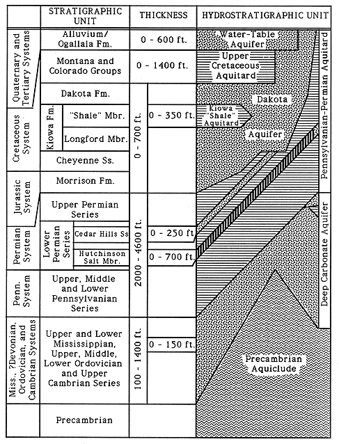
Table 5.2. Regionalized hydraulic conductivity values of the aquifer and aquitard units in the shallow subsurface of western and central Kansas.
| Hydrostratigraphic Unit | Hydraulic Conductivity (ft/day) | Source |
|---|---|---|
| Water-table aquifer | 80 (20-1600) |
Stulken et al. (1985) |
| Upper Cretaceous aquitard | 10-5 - 10-7 | Belkitz and Bredehoeft (1988); Watts (1989) |
| Dakota aquifer (upper and lower portions) |
19 (1-1500) |
Macfarlane et al. (in review) |
| Kiowa "Shale" aquitard | 10-6 | Watts (1989) |
| Pennsylvanian-Permian aquitard |
10-6 | Senger et al. (1987) |
| Cedar Hills aquifer | 5 | Helgeson et al. (in press) |
The Pennsylvanian-Permian Aquitard
The upper part of the Pennsylvanian-Permian aquitard consists of Upper and Lower Permian Series red bed-evaporite sequences and salt-cemented sandstones of the Cedar Hills Sandstone. Fractures are assumed to be the primary pathway of fluid movement through this aquitard. In the Palo Duro basin of Texas, Kreitler et al. (1985) report a regionalized hydraulic conductivity of 10-6 ft/day for the evaporite aquitard, a hydrostratigraphic unit consisting of similar lithologies to the Permian aquitard defined in this study. They concluded that flow through fractures is much more significant than porous-media flow through the aquitard in the Palo Duro basin.
Cedar Hills Sandstone Aquifer
Within the Permian aquitard the saltwater-bearing Cedar Hills Sandstone aquifer is composed of sandstones not presently salt-cemented. Ground-water flow is from structurally higher areas in southwest Kansas, Oklahoma and southeastern Colorado toward discharge areas where the aquifer is hydraulically connected to the Dakota aquifer in central Kansas. Regional simulation of the steady-state flow system covering a large part of the central midcontinent indicates that the rate of discharge from the Permian is on the order of 0.1 ft3/sec in central Kansas (Helgeson et al., in press). In this area the Cedar Hills aquifer is in contact with the overlying Dakota aquifer (Figure 5.1). The Cedar Hills aquifer is assumed to be slightly less permeable than the Dakota aquifer within the cross section. Plates 10 and 11 show the altitude of the Cedar Hills Sandstone top and the thickness of the Cedar Hills Sandstone beneath the Dakota aquifer in Kansas.
Figure 5.1. Area of central Kansas where the Dakota and Cedar Hills aquifers are hydraulically connected.
Dakota Aquifer
Overlying the Permian aquitard and Cedar Hills aquifer is the Dakota aquifer which consists of upper and lower portions, separated by the "Kiowa Shale" aquitard member of the Kiowa Formation. On the basis of similar lithology and depositional environments, the hydraulic conductivity of the "Kiowa Shale" aquitard is assumed to be 10-6 ft/day which is similar to that of the Skull Creek Shale in South Dakota (Bredehoeft et al., 1983). Where the "Kiowa Shale" aquitard is not present, the Dakota-Kiowa Formation boundary separates upper and lower portions of the Dakota aquifer. Interbedded fluvial, paralic and offshore sandstones and mudstones in the Dakota Formation, Longford Member of the Kiowa Formation and the Cheyenne Sandstone comprise the Dakota aquifer framework.
In central and widely separated areas of southwestern Kansas, the strata that comprise the Dakota aquifer crop out at the surface and the aquifer is unconfined. Elsewhere, in southwestern Kansas the aquifer subcrops beneath Cenozoic deposits and is hydraulically connected to the water table. Where covered by the Upper Cretaceous aquitard, confined flow conditions govern the movement of water. However, in parts of central Kansas adjacent to the outcrop the potentiometric surface of the Dakota aquifer is below the top of the Dakota aquifer (Macfarlane, Townsend, Whittemore, et al., 1988).
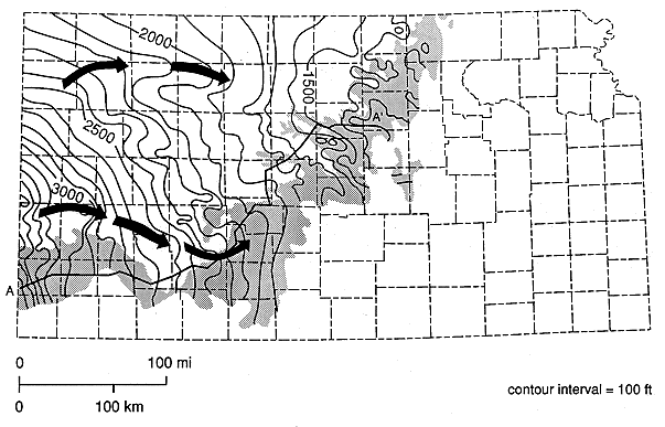
Figure 5.2 (Plate 1 is a larger sized map of Figure 5.2) is a map of the assumed pre-development potentiometric surface of the Dakota aquifer in central and western Kansas. Two primary ground-water-flow corridors can be identified from this map. Ground waters move along these flow paths from recharge areas in southwest Kansas-southeast Colorado to discharge areas in the central part of Kansas. One flow path parallels the outcrop and subcrop areas of the aquifer and is heavily influenced by local sources of recharge and discharge. The other flow path is northeastward through the confined portion of the Dakota aquifer and eastward into north-central Kansas discharge areas. The Dakota aquifer is primarily recharged by precipitation falling on the outcrop and the overlying water-table aquifer in southwest Kansas and by the underlying Cedar Hills aquifer where they are hydraulically connected in the central part of the state. Belitz and Bredehoeft (1988) estimate that the Dakota aquifer receives only 9.0 ft3/sec through the Upper Cretaceous aquitard in all of the Denver basin and areas to the east, whereas the aquifer receives 29.2 ft3/sec in outcrop/subcrop areas in southwestern Kansas and southeastern Colorado. Discharge from the Dakota aquifer to overlying aquifers and surface waters is estimated to be 30.4 ft3/sec in southwestern and central Kansas and southeastern Colorado. The total thickness strata that comprise the Dakota aquifer range up to 750 ft in the cross section.
Figure 5.2. Configuration of the predevelopment potentiometric surface of the upper part of the Dakota aquifer in Kansas.
Upper Cretaceous Aquitard
Over much of western and central Kansas, Upper Cretaceous shales and interbedded chalky shales and thin-bedded limestones form the Upper Cretaceous aquitard that overlies the Dakota aquifer. Fluids move through the Upper Cretaceous aquitard very slowly, primarily through fractures. Belitz and Bredehoeft (1988) have shown that Upper Cretaceous strata in the Denver basin and the adjacent High Plains severely limit the amount of recharge received by the Dakota aquifer. From their steady-state simulation of the regional flow system, Belitz and Bredehoeft concluded that the hydraulic conductivity of the strata comprising the Upper Cretaceous aquitard is on the order of 10-5 ft/day.
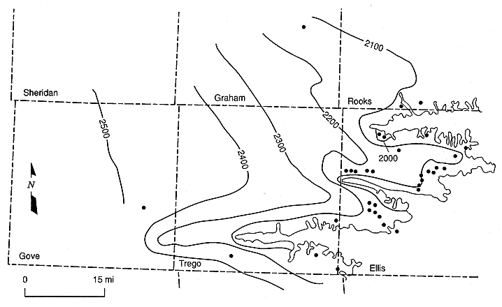
Contained within the Upper Cretaceous aquitard is a minor, locally discontinuous aquifer, the Codell Sandstone aquifer. Silty sandstone to siltstone of the Codell Sandstone Member, Carlile Shale, makes up the bulk of the aquifer framework. Maximum thickness of the aquifer ranges up to 10 feet in parts of western Kansas. Figure 5.3 shows the potentiometric surface of this aquifer near its outcrop in central Kansas.
Figure 5.3 Configuration of the potentiometric surface of the Codell Sandstone aquifer in central Kansas.
Water-Table Aquifer
At the surface the water-table aquifer consists of the High Plains aquifer in southwest Kansas and the alluvial valley aquifers in the central part of the state. Ground-water flow in the High Plains aquifer is generally from west to east toward discharge areas in the river valleys of central Kansas. Figure 5.4 shows the configuration of the pre-development water table in the High Plains aquifer from Stulken and Pabst (1982). The pre-development saturated thickness of the water-table aquifer ranges up to 400 feet in the southwest part of the state. Recharge to the water table in southwest Kansas is estimated to range up to 0.25 inches per year in areas of sandy soils, and the regionalized hydraulic conductivity is estimated to be 80 ft/day (Stulken et al., 1985).
Figure 5.4. Configuration of the predevelopment water table of the High Plains aquifer in Kansas. Adapted from Stulken et al. (1985)
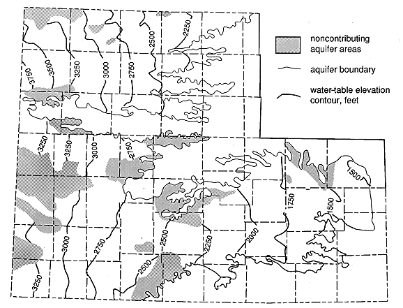
Figure 5.5 is a plot of fluid pressure vs. depth profiles for the Dakota aquifer and underlying Permian from data collected at a number of sites in Kansas. Individual profiles are plotted in the figure rather than the fluid pressure-depth data points in order to emphasize the differences between sites of measurement and to avoid problems of misinterpretation due to topographic effects and sparse data (Orr and Kreitler, 1985).
Figure 5.5. Fluid pressure vs. depth profiles for the Dakota and subjacent Permian aquifers in central and western Kansas.
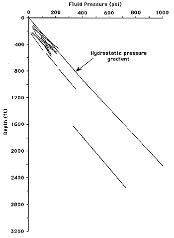
Most of the profiles plot entirely below and are parallel to the line representing the rate of hydrostatic pressure increase with depth. The plotted profiles show that the Dakota aquifer and underlying Permian are subnormally pressured in northwest and in much of central Kansas. Most of the profiles through the Dakota aquifer interval are nearly parallel to the rate of hydrostatic-pressure increase suggesting little or no tendency for vertical movement within the aquifer.
However, some of the fluid-pressure gradients are higher than hydrostatic in the upper part of the Permian and lower part of the Dakota aquifer in central Kansas. Pore pressure-depth data from drill-stem tests of aquifer units below the Cedar Hills Sandstone aquifer down to the top of the Precambrian show increasing degrees of subnormal pressure with depth throughout western and central Kansas. Figure 5.6 shows a typical fluid pressure vs. depth profile from the surface down to the Arbuckle aquifer in central Kansas. Fluid pressures are considerably less than hydrostatic below the top of the Permian aquitard. Equivalent freshwater hydraulic heads in the Arbuckle are as much as 2000 feet below the water table in southwestern Kansas and 500 feet below the water table in central Kansas (Jorgensen et al., in press).
Figure 5.6.Fluid pressure vs. depth from land surface into the Arbuckle, western Russell County, Kansas.
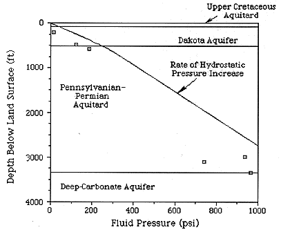
Figure 5.7. Distribution of hydraulic head in a cross section of the shallow subsurface extending from southwestern into central Kansas.
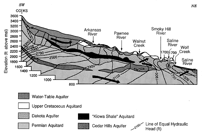
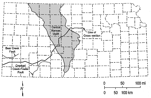
Figure 5.8. Surface trace of the cross section extending from southwestern into central Kansas.
Ground-water flow within the plane of the cross section is from recharge areas in southwestern Kansas and southeastern Colorado eastward and northeastward toward discharge areas in central Kansas. Southwest of the Pawnee River valley, the Dakota aquifer receives freshwater recharge from the overlying water-table aquifer where the Upper Cretaceous aquitard is not present. The ground-water-flow direction is generally parallel to bedding in the upper and lower portions of the aquifer. Hydraulic heads are slightly less in the lower portion of the Dakota aquifer than in the upper portion indicating downward movement through the "Kiowa Shale" aquitard. In this part of the cross section the Dakota aquifer appears to act as a conduit transporting ground waters away from the water-table aquifer in southwestern Kansas.
Below the Dakota aquifer, steep hydraulic-head gradients are present in the Permian red bed-evaporite aquitard southwest of the Arkansas River indicating downward flow of water from the upper Permian to aquifers farther down in the Permian-Pennsylvanian. This steep gradient is associated with a closed potentiometric low in the Pennsylvanian in the Anadarko basin (Larson, 1971). Belitz and Bredehoeft (1988) attributed this potentiometric low to the osmotic movement of water downward into this aquitard in response to chemical concentration gradients in the upper part of the Pennsylvanian-Permian aquitard.
Near the Pawnee River valley in central Kansas, the vertical component of flow is upward from the upper part of the Permian into the lower Dakota aquifer. However, the local-scale flow system around the Pawnee River extends only to shallow depth beneath the valley. Below the upper part of the Permian at the bottom of the cross section, the flow through the Permian red bed-evaporite sequence is downward toward the deep-carbonate aquifer. As a result a "ground-water divide" is present just below the top of the Pennsylvanian-Permian aquitard and separates vertically upward and downward components of the flow system in the Pennsylvanian-Permian aquitard and Cedar Hills aquifer. Thus, it appears from the flow pattern and the pore pressure vs. depth profiles that the Cedar Hills aquifer and overlying Permian aquitard are slightly overpressured with respect to overlying and underlying hydrostratigraphic units. This "ground-water divide" continues to near the end of the cross section in the Saline River valley.
Farther along the cross section between the Pawnee River and Walnut Creek and extending into the outcrop areas, the Dakota aquifer receives recharge from the upper part of the Permian red bed-evaporite aquitard and the Cedar Hills Sandstone aquifer near the outcrop. Coincidentally, the Dakota aquifer becomes confined by the Upper Cretaceous aquitard and recharge from the overlying water-table and precipitation is restricted. Upward migration of ground waters from the Cedar Hills and Permian red bed-evaporite aquitard is facilitated by pinch-out of the "Kiowa Shale" aquitard and disappearance of the Permian aquitard above the Cedar Hills Sandstone aquifer. Saltwater moves upward from the Cedar Hills aquifer and lower portion of the Dakota aquifer into upper portions of the Dakota aquifer in the vicinity of the Smoky Hill and Saline River valleys. As a result, this produces a mixed cation-mixed anion type water with elevated dissolved-solids concentration and at several localities precipitation of calcite in sandstones of the lower part of the Dakota Formation. Eventually these waters become part of the local-scale flow system in the vicinity of the Saline River and are discharged laterally from the Dakota aquifer into nearby stream/aquifer systems.
Westward of the Dakota aquifer outcrop belt, lateral drainage of water from the aquifer to streams and upward movement of saline waters from the Cedar Hills aquifer is probably much more significant than recharge through the Upper Cretaceous confining layer. Recharge is probably limited to those areas where the overlying aquitard is fractured. As a result, the uppermost part of the Dakota aquifer is slowly draining. At one location within five miles of the outcrop belt, Macfarlane, Townsend, Whittemore, et al. (1988) found that the hydraulic head in the uppermost part of the Dakota aquifer was lower than the top of the aquifer indicating unconfined conditions at the top of the aquifer. This is consistent with the Belitz and Bredehoeft (1988) conceptual model of flow in the Dakota aquifer for the Denver basin and adjacent areas to the east.
However, the evolution of sedimentary basins, involving uplift, deposition, and erosion causes major changes in basin hydrodynamics and the hydrochemistry of basinal fluids. Transient flow conditions induced by geologic processes acting over finite periods of geologic time produce changes in the flow system at a rate that depends on the hydraulic diffusivity (the ratio of transmissivity/storativity or hydraulic conductivity/specific storage) of the rock framework and the arrangement and thickness of aquifer and aquitard units in the basin (Toth and Millar, 1983; and England and Freeze, 1988). The duration and magnitude of these changes is directly related to modifications in the flow-system boundary conditions caused by geologic processes acting on the basin. These changes in the boundary conditions relate principally to modifications in the configuration of the water table over time. Regional uplift or subsidence and erosional and depositional processes can cause transient adjustments of hydraulic heads by elevating or lowering the surface topography, causing changes in the the elevation of the water table and propagating changes in the pore pressure distribution downward below the zone of saturation (Bradley, 1975). Thus, an overprinting of a more recent pattern of ground-water movement on a relict flow system may occur as a result of tectonic movements or changes in the topography in the basin. Toth (1972) has shown that the time of adjustment may be geologically significant, on the order of millions of years, if aquitards of substantial thickness are present in the subsurface.
Several examples of this behavior have been identified in the midcontinent region. Pollastro and Scholle (1986) and Rice (1984) attributed pore pressures higher than hydrostatic in shallow Niobrara gas fields along the eastern edge of the Denver basin to removal of overburden during the Tertiary and Quaternary. Senger et al. (1987) and Dutton and Simpkins (1989) were able to explain subnormal pressures in the deepest part of the Palo Duro basin in the Texas panhandle and the isotropic geochemistry of shallow ground waters, respectively, by examining the Cenozoic erosional and tectonic history of the region for the last 15 million years.
The presence of the "ground-water divide" in the cross section and anomalously high pore pressure gradients below the Permian-Cretaceous boundary are unexpected. Furthermore, the occurrence of subnormal fluid pressures in the consolidated rock aquifers indicates that the flow systems in these aquifers are not in equilibrium with the overlying water table. These phenomena, and possibly including Larson's (1971) closed potentiometric low in the Pennsylvanian, may be attributed to a time lag in the response of the regional ground-water flow system to tectonic and erosional events that have taken place in the High Plains region during the Cenozoic Eras.
The geologic record of the High Plains in Kansas is not continuous throughout the latest Cretaceous and Cenozoic and must be inferred from what is known about the early part of this time period in eastern Colorado and Nebraska (Kirkham and Ladwig, 1980; Stout et al., 1971). However, the geologic events that occurred in Kansas during the Miocene-Pliocene and Quaternary are reasonably well known (Smith, 1940; Frye, 1945; Frye and Leonard, 1952; Merriam and Frye, 1954; Merriam, 1963; and Frye, 1970). Table 5.3 is a summary of the geologic processes active in central Kansas and Rocky Mountain foreland adjacent to the mountain front in Colorado.
Table 5.3. Summary of the geologic history of western Kansas and eastern Colorado.
| Geologic Event/Process | Approximate Time and Duration | Probable Effect on the Regional Ground-water-flow System |
|---|---|---|
| Retreat of the inland sea; erosion | Late Cretaceous (prior to approx. 67 m.y. ago) |
Creation of a regional ground-water-flow system and surface drainage. |
| Initial uplift of the Rocky Mountains | Late Cretaceous-Paleocene (approx. 67-57 m.y. ago) |
Elevation of the water table in E. Colorado; possible reversal of the ground-water-flow directions |
| Uplift of the Front Range; deposition of sediments |
Eocene (approx. 58-36 m.y. ago) |
Elevation of the water table and outcrop of the Dakota aquifer part Penn-Permian aquitard in SW Kansas; Possible alteration of ground-water-flow directions |
| Deposition of the Ogallala Formation | Miocene-Pliocene (approx. 15-3 m.y. ago) |
Differential elevation of the water table and the land surface; creation of a regionally significant water-table aquifer. |
| Eastward tilting in eastern Colorado | Pleistocene (approx. 3 m.y. ago to present) |
Elevation of the water table in eastern Colorado |
| Retreat of the Greenhorn escarpment in central Kansas |
Late Pleistocene-Recent (approx 3 m.y. ago to present) |
Discharge of waters from the Dakota aquifer and Permian to streams |
| Erosional decompaction during escarpment retreat |
Pleistocene-Recent (approx 1.6 m.y. ago to present) |
Decrease in hydraulic heads eastward of the Greenhorn escarpment in central Kansas |
Episodes of erosion and deposition and tectonic movements have caused major changes in the water-table configuration in central and western Kansas during the Cenozoic Era. In the early and middle part of the Tertiary, the area underwent several periods of uplift and cycles of erosion and deposition so that prior to the Miocene only a thin cover of Upper Cretaceous strata remained in central Kansas. Stream erosion removed between 1000 and 3000 ft of Cretaceous strata from the central Kansas area (Pollastro and Scholle, 1986). Also, the High Plains region in Kansas was tilted slightly to the northwest prior to the Miocene (Merriam, 1963). This would have increased the elevation of the water table and consequently hydraulic heads in the water-table aquifer in the southern part of the regional ground-water flow system relative to the northern portion. Erosion stripped off the Cretaceous and Jurassic strata in southwest and southeastern Colorado uncovering the Dakota aquifer and the underlying Permian red bed-evaporite aquitard, lowering the elevation of the water table in the recharge area. Eastward of the central Kansas area, the Dakota aquifer cropped out beneath the westward-retreating Fort Hays and Greenhorn escarpments. The recharge area for the Dakota aquifer was probably the southeast Colorado-southwest Kansas area during this time and the flow path would have extended from this area to discharge areas eastward of central Kansas. At this time the vertical direction of ground-water flow may have been downward into the Permian from the surface. Pore pressures may have slowly begun to adjust to the removal of overlying Cretaceous and Jurassic strata in southwestern and central Kansas, northwestward tilting of the region, and the new water-table configuration. Downward propagation of transient changes in pore pressure probably continued to lag behind adjustments in the water-table configuration at the end of pre-Ogallala time as the land surface was eroded. Prior to the deposition of the Ogallala Formation, the dissected Greenhorn escarpment may not have retreated to the present position in central Kansas.
With the deposition of the Ogallala in the Miocene-Pliocene, the westward retreat of the Fort Hays and Greenhorn escarpments was halted. Water-saturated sediments deposited in southwestern Kansas and southeastern Colorado probably provided a more consistent source of recharge to the Dakota aquifer than precipitation on the outcrop surface. A maximum of 100 feet of Miocene-Pliocene sediments was deposited in the central Kansas area (Merriam, 1963). With the deposition of the overlying unconsolidated sediments, the Dakota aquifer was flushed of connate waters in the shallow subsurface by recharge from the water-table aquifer. Hydraulic heads in the Dakota aquifer would have increased in southwest and south-central Kansas in response to deposition of water-saturated Ogallala sediments. Increased hydraulic heads in the discharge area might have slowed or eventually shut-off the upward movement of saltwater from the Permian toward shallow aquifers and surface waters.
Later in the Pliocene and into the Quaternary, eastward tilting of the High Plains rejuvenated streams in central and western Kansas and caused erosion of the Ogallala Formation, retreat of the Greenhorn escarpment into central Kansas and entrenchment of streams. Frye (1945) estimates that approximately 150 feet of Cretaceous strata and Ogallala Formation were removed from the Saline River valley in central Kansas during this time. Eastward tilting would have increased the elevation of the water table in western Kansas and eastern Colorado causing the Dakota and underlying aquifers to be more subnormally pressured. Removal of the water-saturated sediments above the Dakota aquifer in discharge areas would have lowered hydraulic heads in the outcropping Dakota aquifer of central Kansas and established a new water-table configuration. At the present time, pore pressures in the Permian and older strata of central Kansas are probably adjusting to changes in the water-table configuration brought about by this latest (late Pliocene-Quaternary) cycle of erosion.
As a result of these erosional and depositional episodes, the present-day regional ground-water flow system is composed of modern and relict components in the cross section from southwest to central Kansas. The modern portion of the system flows through the water-table aquifer and local flow systems where the Dakota aquifer strata crop out in central Kansas. The relict part of the system flows through the consolidated-rock hydrostratigraphic units that have hydraulic conductivities much lower than the water-table aquifer. Pore pressures in this part of the system may not have completely adjusted to changes in the water-table configuration that have been occurring during the last 67 Ma in the central Kansas area. Higher-than-expected pore pressures in the Cedar Hills aquifer and upper portions of the Pennsylvanian-Permian aquitard may be a "fossil" remnant of an older ground-water-flow system that functioned in the geologic past. The establishment of the modern ground-water-flow system in central Kansas is probably closely related to the retreat of the Greenhorn escarpment into central Kansas and downcutting by streams through the Upper Cretaceous aquitard and into the Dakota aquifer framework. However, details concerning the evolution of this flow system and the effect of tectonic and erosional processes through time are unclear at present. Further research using simulation needs to be carried out to reconstruct the relict flow system and assess the effects of these processes through time.
The disequilibrium between the shallow and deeper flow systems is hypothesized to be the result of a delayed response in time to changes in the water-table configuration caused by Cenozoic episodes of deposition, erosion, and tilting in the western and central Kansas areas during the last 15 million years. The present distribution of hydraulic head in the cross section is a composite of modern and relict ground-water flow systems due to the slow propagation of pore-pressure changes in the deeper flow system. This has resulted from the low hydraulic conductivity of the aquifer and aquitard units below the water-table aquifer. Further research needs to be done to explore the effects of past geologic processes on the regional ground-water flow system in western Kansas in order to confirm or reject this hypothesis.