Kansas Geological Survey, Current Research in Earth Sciences, Bulletin 262
![]()
![]()
Kansas Geological Survey, Current Research in Earth Sciences, Bulletin 262
![]()
Kansas Geological Survey
Summary and citation information available for this article. The complete article is available as an Acrobat PDF file (820 kB). You will need the Acrobat PDF Reader, available free from Adobe, to read this report.
The age of red beds exposed below the bluff-capping Ogallala Formation at Point of Rocks in Morton County, Kansas, has been disputed since they were first recognized in the late 1800s. Over the years, nearly 25 maps and reports have variously classified the strata as Cretaceous, Jurassic, Triassic, or Permian, creating an interesting history of speculation and stratigraphic nomenclature. Many of the interpretations relied on the indirect method of comparing lithologies to similar exposures in surrounding states, but none were in-depth studies. Until recently, the Kansas Geological Survey has considered the rocks to be Jurassic based on Zeller (1968), the currently recognized stratigraphic guide and chart for Kansas. A comprehensive study by Smith et al. (2015)--using outcrop descriptions, subsurface information, and detrital zircon data--constrained the age of the red beds at Point of Rocks, assigning them to the Guadalupian Big Basin Formation, the uppermost Permian unit in Kansas.
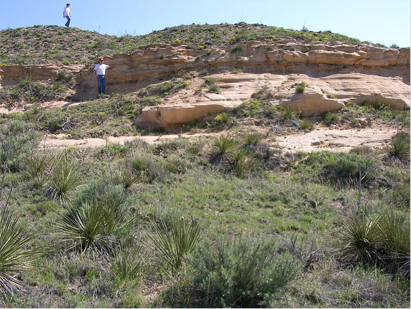
Point of Rocks, a well-known landmark along the Santa Fe Trail's Cimarron Cut-off (known as the Dry Route), rises above the Cimarron River valley and is capped by a flat-topped outcrop of Ogallala Formation (Neogene) calcrete (fig. 1). An isolated exposure of older rocks--red and tan beds of sandstone, siltstone, and shale--crops out in a small area below the Ogallala (figs. 2 and 3). Until recently, these rocks were assigned to the Jurassic System (Zeller, 1968).
Figure 1--Aerial view of Point of Rocks with the Cimarron River valley in the foreground. The landmark's parking area sits on top of the Ogallala and the red beds are exposed near the base of the bluff (photo by William C. Johnson).
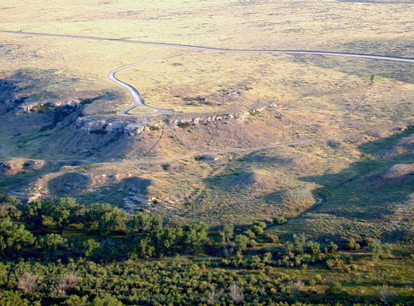
Figure 2--Red beds exposure below Point of Rocks. Scale (left) is in feet.
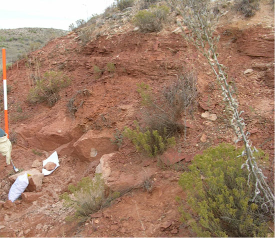
Figure 3--Sandstones and siltstones below the Ogallala at Point of Rocks.
Historically, many have classified these rocks as Triassic, while others have suggested they may be Jurassic, Cretaceous, or Permian. Conjecture about the age has always relied on comparison to lithologically similar rocks of known ages in Oklahoma, Colorado, and New Mexico, but this method has never provided a reliable interpretation. Fossils that would help determine the age of this exposure appear to be absent (Smith, 1940; Liggett and Zakrzewski, 1997; Liggett et al., 1998; Smith et al., 2015).
Since the late 1800s, geologists have offered a variety of opinions about the age of the red beds at Point of Rocks, but an in-depth study had never been conducted. Recently however, in a comprehensive study that incorporated detrital zircons, outcrop data, and subsurface information, Smith et al. (2015) determined the age of the red beds to be Permian.
This is a companion paper to Enigmatic Red Beds Exposed at Point of Rocks, Cimarron National Grassland, Morton County, Kansas: Chronostratigraphic Constraints from Uranium-Lead Dating of Detrital Zircons by Smith et al. (2015). This paper presents a detailed chronological history of the literature and varied classifications associated with what many consider the last contentious exposure in Kansas. It also documents information pertinent to the stratigraphic nomenclature of the Jurassic System in Kansas.
The first geologic map of Kansas to appear in a Kansas Geological Survey (KGS) publication (Haworth, 1896; Buchanan, 1989) and similar early geologic maps (Moore and Haynes, 1917, plate 1) show exposures of Cretaceous Dakota along drainages in Stanton and Morton counties and specifically in the vicinity of Point of Rocks. Gould (1901, p. 135) was the first to mention the exposure at Point of Rocks while describing isolated outcrops of the Dakota Group in the extreme southwestern corner of Kansas:
Point of Rocks, in Morton county, a line of bluffs on Bear creek, in Stanton county, and several exposures between these, on the North Fork of the Cimarron, are referred to this group.
Gould also states (p. 139) that "Triassic and Jurassic rocks are totally wanting, unless they are represented in the upper part of the Red-beds of Kansas and Oklahoma." This sentence, however, is footnoted as follows:
Since the above was written, it has been demonstrated that the upper part of the problematic Kansas-Oklahoma Red-beds is Triassic. Vertebrates taken from the lower part of these beds, in eastern Oklahoma, have been identified by Dr. S. W. Williston as Permian forms, similar to those from the Texas Permian. On the other hand, invertebrates obtained from near the top of the Red-beds in western Oklahoma are classed as Triassic forms, on the authority of Dr. J. W. Beede and Mr. Charles Schuchert. The line of separation between the two series of rocks has been drawn provisionally at the heavy ledge of gypsum that caps the Gypsum Hills of Kansas and Oklahoma.
Gould's "heavy ledge of gypsum" is presumably the Blaine Formation. Although not specifically stated, it is probable that Gould is including the Point of Rocks exposure in what he refers to as the problematic red beds of Kansas-Oklahoma.
Geologic Map of Kansas (Moore and Landes, 1937) was the first 1:500,000 scale, large-format, full-color geologic map published by the KGS (Buchanan, 1989). It shows Dakota Group and Triassic(?) red beds in the Point of Rocks area.
In Permian Redbeds in Kansas, Norton (1939) suggested that "a small exposure in Morton County" (presumably, he was referring to Point of Rocks) may be Big Basin Formation and may occupy a position higher in the section than the exposed thickness of the Big Basin in Clark County. Norton had not studied the Morton County exposure and presented no additional information about why he thought the exposure might be Permian.
Smith (1940) described about 20 ft of "red chippy shale" (red beds) overlain by approximately 40 ft of "fine-grained cross-bedded yellowish to buff sandstone containing some red bands" at "Point Rock" in Morton County. He concurs with Moore and Landes (1937) that the red beds are Triassic(?), although he states that "their occurrence . . . in southwestern Kansas is debatable." He goes on to say "the upper sandstone differs in appearance from typical Dakota, and may possibly be Jurassic or Early Cretaceous age." He later identifies "the sandstone overlying red beds at the Point Rock section in Morton county" as the Lower Cretaceous Cheyenne Sandstone.
The KGS published a bulletin on the geology and groundwater resources of Morton County in 1942 (McLaughlin, 1942). McLaughlin states that Permian red beds are not exposed in Morton County but do occur in the subsurface, but he thought the Day Creek Dolomite and the Taloga formation (now the Big Basin Formation [O'Connor, 1963]) were probably absent. McLaughlin classified the exposure at Point of Rocks as Triassic(?) and compared the lithologic similarities there with the red beds in the Red Point district in Texas County, Oklahoma, that Schoff (1939, p. 49-51) and others called Triassic(?) (McLaughlin, 1942, p. 71). He goes on to state:
The beds at Point Rock and Red Point generally are correlated with the Dockum group of Texas, New Mexico, and Colorado, rocks which are Triassic, probably Upper Triassic. The beds are lithologically similar to the Tecovas formation, the lower part of the Dockum group of the Texas panhandle.
He also cited Gould's footnote (previously quoted and discussed in this section) that suggests the Point of Rocks exposure is Triassic.
The KGS and USGS drilled a 200 ft test hole at Point of Rocks in 1940. McLaughlin (1942, test hole 8, p. 108) logged 12 ft of soil and alluvium and 188 ft of Triassic(?) red beds in the test. The test location was probably at the base of the exposure at Point of Rocks in the flood plain of the Cimarron River based on the reported elevation (3,427.6 ft) and the 12 ft of alluvium that was logged. The reported location (NE sec. 12, T 34 S, R 43 W) puts the test hole east of Point of Rocks about 100 ft higher than the reported elevation and in the uplands above the Ogallala outcrop. The correct location of test hole 8 is probably NE SE sec. 12.
Moore et al. (1944) and Moore et al. (1951, 1952) classified the rocks at Point of Rocks as Triassic(?) Dockum(?) Group, unnamed formation, and Triassic Dockum(?) Group, respectively, based on correlations with rocks of similar lithologies in Oklahoma, Texas, and New Mexico. A rock chart by Jewett (1959) shows the Triassic Dockum Group in the subsurface only but with a note that states "Some part of the Triassic section is believed to crop out in a small area in Morton County."
Based on a summary of the literature, Merriam (1963a, p. 122; 1963b, p. 75) stated that rocks of Triassic age "are known to occur only in the extreme southwestern part" of the state. Citing Moore et al. (1951) and Moore et al. (1952), he assigned them to the Dockum(?) Group.
Subsequent versions of Moore and Landes' (1937) 1:500,000 scale geologic map (Kansas Geological Survey, 1964, 1991) depict the exposure at Point of Rocks as Ogallala Formation and Triassic Dockum Group.
The Stratigraphic Succession in Kansas (Zeller, 1968, p. 53) classified the exposure at Point of Rocks as Jurassic:
Deposits judged to be Jurassic in age...occur in the subsurface in northwestern Kansas and crop out in a small area in southern Morton County. They consist primarily of varicolored shales and red sandstones and attain a maximum thickness of about 350 feet. In the subsurface they pinch out eastward along an irregular line extending from Morton County to Smith County and, in general, thicken toward the west. The Jurassic beds in southwestern Kansas, formerly classified as Triassic, Dockum (?) Group, have been restudied and are now designated as undifferentiated Jurassic (E. D. Gutentag, personal communication with H. G. O'Connor, 1966, 1967; see also Voegeli and Hershey, 1965).
(The Voegeli and Hershey [1965] reference did not specifically discuss the exposure at Point of Rocks.)
Archived files related to judgments made by the KGS's stratigraphic nomenclature committee during the development of Zeller (1968) contain correspondence that explains the decision to classify the exposures at Point of Rocks as Jurassic and provide details concerning the personal communication between E. D. Gutentag and H. G. O'Connor in 1966 and 1967 (Sawin, 2015). Gutentag was with the U.S. Geological Survey and O'Connor was chairman of the Committee on Stratigraphic Nomenclature at the KGS. Chronologically, here is what transpired:
15 March 1966--Memo from Gutentag to O'Connor redesignating the rocks called Triassic(?) to "undifferentiated Jurassic."
29 September 1967--Memo from Gutentag to O'Connor outlining his arguments for designating the rocks "undifferentiated Jurassic" based on reinterpretation of test hole 8 (McLaughlin, 1942; Gutentag recognized the Day Creek Dolomite, the lower part of the Big Basin Formation, and the Permian-Jurassic contact in the test), subsurface correlations, and surface correlations by similar lithology.
20 October 1967--Memo from O'Connor to the KGS Committee on Stratigraphic Nomenclature file. Gutentag's changes were accepted by the committee for publication in Zeller (1968) because "Gutentag's knowledge and recommendation of the Mesozoic in Southwest Kansas is probably the best we have." It was noted in the memo that a publication with Gutentag's suggested changes that could be cited in Zeller (1968) would be preferable.
13 November 1967--Memo from O'Connor to Gutentag asking for a citable reference changing the Triassic(?) to undifferentiated Jurassic. Gutentag had apparently agreed to publish such a paper.
16 November 1967--Memo from Gutentag to O'Connor with authorship and a title for the requested paper but stating that the paper would not be finished before Zeller (1968) was published. The proposed paper was never published.
Since the KGS's accepted stratigraphic guide and chart for Kansas was published (Zeller, 1968), the age of the older rocks at Point of Rocks has remained controversial, as more reports continued to speculate about whether the strata there were Triassic (Kansas Geological Survey, 1991; McNinch, 1996; Liggett and Zakrzewski, 1997; Liggett et al., 1998; Croxton et al., 1998) or Jurassic (Kume and Spinazola, 1985). All of these papers relied on existing citations and provided no new information concerning the age of the red beds.
Johnson et al. made a new geologic map of Morton County in 2009. They mapped the red beds below Point of Rocks and, in the published version, followed KGS nomenclature guidelines and Zeller (1968) in classifying these rocks as Jurassic. In prepublication drafts of the map, however, they designated the red beds as Cheyenne Sandstone (Cretaceous) based on regional lithologic comparisons.
In a more comprehensive study, Smith et al. (2015) used detailed measured sections, detrital zircon data, and subsurface correlations to constrain the age of the red beds at Point of Rocks. They assigned the rocks below the Neogene Ogallala Formation to the Guadalupian Big Basin Formation, the uppermost Permian unit in Kansas.
For more than a century, this unique, isolated outcrop of red beds at Point of Rocks in extreme southwestern Kansas intrigued geologists. While economically unimportant, it was scientifically a mystery--and the last place in the state where the age of the strata had not been determined. Early maps depicted the area as Cretaceous Dakota Formation. Norton guessed right (Permian) in 1939 but, ironically, had not even seen the exposure. McLaughlin (1942) was the first to map the area and drill a test hole near the outcrop. He decided it was probably Triassic but qualified that with a question mark. The KGS's long-standing position was outlined in Zeller (1968) where the red beds at Point of Rocks were judged to be Jurassic. That was the KGS's official stance until Smith et al. (2015) constrained the age to Permian (Big Basin Formation) using detailed field work, subsurface correlations, and techniques that were not available to previous researchers. Based on this work, the KGS no longer supports the occurrence of Jurassic rocks at the surface in Kansas.
The author thanks Neil H. Suneson, William C. Johnson, and an anonymous reviewer for thoughtful, constructive technical reviews of the manuscript. Thanks to Rex Buchanan, Greg Ludvigson, and Jon Smith, all with the KGS, who provided informal reviews and guidance. Additional thanks to Julie Tollefson (KGS) for editorial and publication support and Cathy Evans (KGS) for suggestions that improved the writing quality.
Buchanan, R. C., 1989, 'To bring together, correlate, and preserve'--A history of the Kansas Geological Survey, 1864-1989: Kansas Geological Survey, Bulletin 227, 96 p. [available online]
Croxton, N. M., Geist, J. W., and Peterson, A. E., 1998, Bridge foundation geology report, K-27 over the Cimarron River, Morton County, Kansas: Kansas Department of Transportation, Topeka, Kansas, 8 p.
Gould, C. N., 1901, The Dakota Cretaceous of Kansas and Nebraska: Kansas Academy of Science Transactions, v. 17, p. 122-178.
Haworth, E., 1896, A reconnaissance geologic map of Kansas; in, The University Geological Survey of Kansas, Vol. I: University Geological Survey of Kansas, v. 1, 320 p., Plate 31. [available online]
Jewett, J. M., 1959, Graphic column and classification of rocks in Kansas: Kansas Geological Survey, 1 sheet.
Johnson, W. C., Woodburn, T. L., and Messinger, L. G., 2009, Surficial geology of Morton County, Kansas: Kansas Geological Survey, Map M-116, scale 1:50,000. [available online]
Kansas Geological Survey, 1964, Geologic map of Kansas: Kansas Geological Survey, Map M-1, 1:500,000 scale.
Kansas Geological Survey, 1991, Geologic map of Kansas: Kansas Geological Survey, Map M-23, 1:500,000 scale.
Kume, J., and Spinazola, J. M., 1985, Geohydrology of sandstone aquifers in southwestern Kansas: Kansas Geological Survey, Irrigation Series 8, 49 p. [available online]
Liggett, G. A., and Zakrzewski, R. J., 1997 (revised 1998), Final report on the geological and paleontologic investigation of the Cimarron National Grassland: Fort Hays State University and U.S. Department of Agriculture Forest Service contract #CC2-2-12-94-07-028, 29 p.
Liggett, G. A., Zakrzewski, R. J., and McNinch, K. L., 1998, Geologic and paleontologic investigation of the Cimarron National Grassland, Morton County, Kansas: Dakoterra, v. 5, p. 123-126.
McLaughlin, T. G., 1942, Geology and ground-water resources of Morton County, Kansas: Kansas Geological Survey, Bulletin 40, 126 p. [available online]
McNinch, K. L., 1996, An integrated GIS database, geologic and paleontologic reconnaissance, and areal correlation of soils to geology within Cimarron National Grasslands (sic), Morton County, Kansas: M.S., Fort Hays State University, 99 p.
Merriam, D. F., 1963a, Triassic rocks in Kansas: The Compass, v. 40, no. 2, p. 122-127.
Merriam, D. F., 1963b, The geologic history of Kansas: Kansas Geological Survey, Bulletin 162, 317 p. [available online]
Moore, R. C., Frye, J. C., and Jewett, J. M., 1944, Tabular description of outcropping rocks in Kansas: Kansas Geological Survey, Bulletin 52, pt. 4, p. 137-212. [available online]
Moore, R. C., Frye, J. C., Jewett, J. M., Lee, W., and O'Connor, H. G., 1951, The Kansas rock column: Kansas Geological Survey, Bulletin 89, 132 p. [available online]
Moore, R. C., Frye, J. C., Jewett, J. M., Lee, W., and O'Connor, H. G., 1952, Graphic column of Kansas rocks: Kansas Geological Survey, 1 sheet.
Moore, R. C., and Haynes, W. P., 1917, Oil and gas resources of Kansas: Kansas Geological Survey, Bulletin 3, 391 p. [available online]
Moore, R. C., and Landes, K. K., 1937, Geologic map of Kansas: Kansas Geological Survey, scale 1:500,000.
Norton, G. H., 1939, Permian redbeds in Kansas: Bulletin of the American Association of Petroleum Geologists, v. 23, no. 12, p. 1,751-1,815.
O'Connor, H. G., 1963, Changes in Kansas stratigraphic nomenclature: American Association of Petroleum Geologists Bulletin, v. 47, no. 10, p. 1,873-1,877.
Sawin, R. S., 2015, Copies of archived correspondence pertinent to the decision to classify the exposure at Point of Rocks, Morton County, Kansas, as Jurassic by the Kansas Geological Survey in 1967: Kansas Geological Survey, Open-File Report 2015-2, 11 p. [available online]
Schoff, S. H., 1939, Geology and ground-water resources of Texas County, Oklahoma: Oklahoma Geological Survey, Bulletin 59, 248 p.
Smith, H. T. U., 1940, Geological studies in southwestern Kansas: Kansas Geological Survey, Bulletin 34, 212 p. [available online]
Smith, J. J., Platt, B. F., Ludvigson, G. A., Sawin, R. S., Marshall, C. P., and Olcott-Marshall, A., 2015, Enigmatic red beds exposed at Point of Rocks, Cimarron National Grassland, Morton County, Kansas: Chronostratigraphic constraints from uranium-lead dating of detrital zircons: Kansas Geological Survey, Current Research in Earth Sciences, Bulletin 261, 17 p. [available online]
Voegeli, P. T., and Hershey, L. A., 1965, Geology and ground-water resources of Prowers county, Colorado: U.S. Geological Survey, Water-Supply Paper 1772, 97 p. [available online]
Zeller, D. E., ed., 1968, The stratigraphic succession in Kansas: Kansas Geological Survey, Bulletin 189, 81 p., 1 plate. [available online]
Kansas Geological Survey
Placed online Aug. 26, 2016
http://www.kgs.ku.edu/Current/2016/Sawin/index.html
email:webadmin@kgs.ku.edu