Kansas Geological Survey, Current Research in Earth Sciences, Bulletin 261
![]()
![]()
Kansas Geological Survey, Current Research in Earth Sciences, Bulletin 261
![]()
1Kansas Geological Survey
2University of Mississippi, Department of Geology and Geological Engineering
3The University of Kansas, Department of Geology
Summary and citation information available for this article. The complete article is available as an Acrobat PDF file (12 MB). You will need the Acrobat PDF Reader, available free from Adobe, to read this report.
Point of Rocks, a high-relief bluff overlooking the Cimarron River valley in Morton County, Kansas, is capped by distinct white beds of Neogene Ogallala Formation calcrete that overlie red beds of shale, siltstone, and sandstone. These unfossiliferous red beds are currently assigned to the Jurassic System; however, their age has long been debated due to a lack of marker beds, index fossils, and nearby correlative outcrops. As a result, geologists over the years have assigned the rocks to systems ranging from the Permian to the Cretaceous. In this study, four stratigraphic sections were measured in the red beds and three bulk samples were collected to determine the uranium-lead age distributions of detrital zircon (DZ) populations. Red-bed strata composed of fissile shale and sandstone are interpreted as alluvial overbank deposits, while dominantly trough cross-bedded and planar-laminated sandstones are interpreted as tidally influenced fluvial deposits. Detrital zircon age peaks can be grouped into at least seven subpopulations with a youngest single zircon age of 263.8 ± 12.1 Ma, a more conservative age of 293.0 ± 6.95 Ma based on the youngest grouping of three grain ages overlapping at 2σ, and a complete absence of Mesozoic age zircons. In addition, copper oxides along partings and fractures suggest that the red beds once hosted copper sulfides, a common constituent of regional Permian-Triassic red beds. The DZ data--in conjunction with the identification of the Permian Day Creek Dolomite marker bed in logs of nearby drilling tests--strongly suggest that the enigmatic red beds cropping out at the base of Point of Rocks should be assigned to the Guadalupian Big Basin Formation, the uppermost Permian unit in Kansas.
A prominent bluff in Morton County, Kansas, Point of Rocks was one of the best-known landmarks for 19th-century travelers on the Santa Fe Trail's Cimarron Cutoff, also called the Dry Route (fig. 1), because it signaled proximity to natural springs in a long stretch with few sources of water. Overlooking the Cimarron River valley, the south-facing bluff is capped by distinct white beds of Neogene Ogallala Formation calcrete. Older rocks underlying the Ogallala--red, tan, and gray beds of shale, siltstone, and sandstone--crop out for approximately 500 m along the base of the bluff (figs. 2 and 3). These red beds are currently assigned to the Jurassic System (Zeller, 1968)1. However, the rocks at this isolated exposure have always been problematic and, historically, have been classified as Triassic, Cretaceous, and Permian. Over the years, several geologists have examined the exposed red beds at the base of Point of Rocks for fossils to help determine their age (Smith, 1940; Liggett and Zakrzewski, 1997; Liggett et al., 1998), but the rocks appear to be unfossiliferous. Speculation about their age has been based on correlation to lithologically similar rocks in Oklahoma, Colorado, and New Mexico, where the ages are known. This indirect approach has not provided a definitive solution. The purpose of this paper is to present the results of our study in which uranium-lead ages from detrital zircons were used to improve chronostratigraphic constraints on the deposition of red-bed strata at Point of Rocks.
Figure 1--Map showing the historic Santa Fe Trail and the location of Point of Rocks in the Cimarron National Grassland, Morton County, southwestern Kansas.
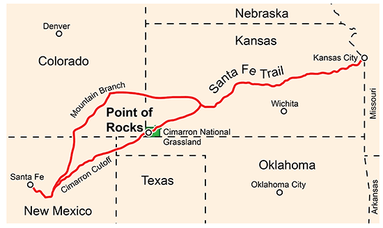
Figure 2--Aerial photo showing the location of the red beds at the base of the bluff, the overlying Ogallala Formation, and the parking area (road loop) atop the Point of Rocks landmark (photo by William C. Johnson).
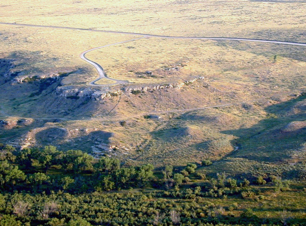
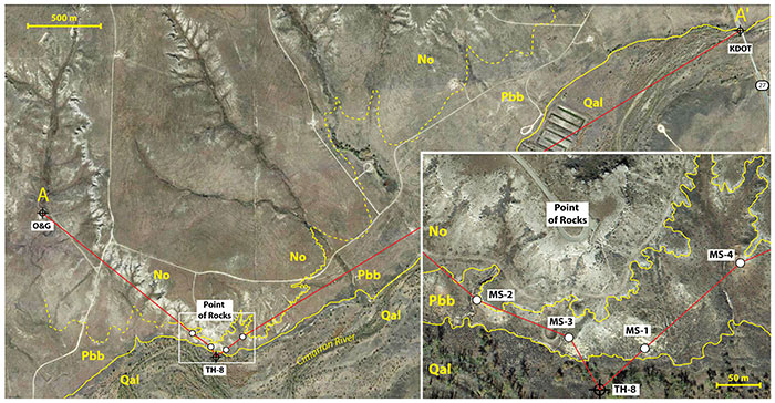
Figure 3--Aerial view of the study area (modified from Google Earth, accessed March 3, 2015) showing location of measured sections and drillers' logs used to construct cross section A-A' (fig. 13). Geologic contacts (yellow lines) between the Neogene Ogallala Formation (No), the Permian Big Basin Formation (Pbb), and Quaternary alluvium (Qal) are based on the results of this study and photo interpretation. Inset shows the locations of the measured sections (MS-1 to MS-4) and test hole 8 (McLaughlin, 1942; test hole 8, p. 108).
Uranium-lead age distributions of populations of detrital zircons (DZ) within a sedimentary unit yield trends that represent the relative contributions of weathered igneous material from particular events or provinces (e.g., Dickinson and Gehrels, 2009, 2010; Dickinson et al., 2010). Comparisons of DZ age distributions between strata can reveal changes in source areas and drainage networks over time. The youngest uranium-lead ages of grains in DZ populations are commonly used to constrain maximum depositional ages (Dickinson and Gehrels, 2010). A growing database of DZ ages from various lithostratigraphic units offers opportunities to compare data from previously unknown samples when searching for similar provenance (Gehrels, 2012). After using this approach and examining previously overlooked subsurface data to constrain timing of deposition, we conclude that the enigmatic strata cropping out at the base of Point of Rocks are red beds of the Permian Big Basin Formation. Results of this study solve a geological riddle that has existed since this exposure was first studied in the late 1800s and can be used to improve future geologic maps of the area, enhance regional stratigraphic correlations in the High Plains, and elucidate the duration of the pre-Ogallala unconformity in this area.
The depositional age of red beds at Point of Rocks has long been debated due to an absence of regional marker beds and index fossils. As a result, the rocks historically have been assigned to geological systems ranging from the Permian to the Cretaceous based on little more than lithologic similarities with distant potential correlatives (fig. 4). The first published mention of exposures at Point of Rocks was by Gould (1901) while describing isolated outcrops of the Dakota Group in the extreme southwestern corner of Kansas. He inferred a Triassic age for red beds in western Kansas based on similar strata in western Oklahoma containing invertebrate fossils, though such fossils were not reported from Kansas deposits. Moore and Landes (1937) in their Geologic Map of Kansas also showed Dakota Group and Triassic (?) red beds in the Point of Rocks area.
Figure 4--Historical stratigraphic interpretations of strata in the Point of Rocks study area compared with the chronostratigraphy proposed in this study.
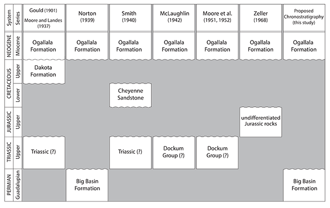
In a publication about the Permian red beds of Kansas, Norton (1939) suggested that "a small exposure in Morton County" (presumably referring to Point of Rocks) may be Big Basin Formation but offered no further evidence or explanation as to why he thought it might be Permian in age. Smith (1940) seemed to have deferred to Moore and Landes (1937) that the red beds are Triassic (?) but identified the overlying sandstone as the Lower Cretaceous Cheyenne Sandstone. McLaughlin (1942) classed the exposures at "Point Rock" (Point of Rocks) as Triassic (?), possibly Upper Triassic Dockum Group, and compared them lithologically to red beds exposed in the Red Point district in Texas County, Oklahoma. Moore et al. (1944) and Moore et al. (1951, 1952) classified the rocks as Triassic (?) Dockum group, an unnamed formation, and Triassic Dockum (?) Group, respectively, based on correlations with rocks of similar lithologies in Oklahoma, Texas, and New Mexico.
The most recently accepted stratigraphic guide and chart for Kansas by the KGS (Zeller, 1968) classified the exposure at Point of Rocks as Jurassic based on personal communications between the KGS's Committee on Stratigraphic Nomenclature and E. D. Gutentag (USGS) in 1966 and 1967 (Sawin, 2015). Since Zeller was published in 1968, the age of the exposure has continued to be controversial, with various authors speculating about whether the rocks were Triassic (Kansas Geological Survey, 1991; McNinch, 1996; Liggett and Zakrzewski, 1997; Liggett et al., 1998; Croxton et al., 1998) or Jurassic (Kume and Spinazola, 1985; Johnson et al., 2009). None of these reports presented new evidence concerning the age of the exposed rocks and all were based on existing literature summarized herein.
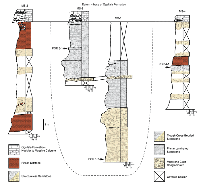
Four stratigraphic sections were measured in the red beds at the base of Point of Rocks along the north wall of the Cimarron River valley (fig. 5). All units were measured with a Jacob staff and sighting level. Lithologic units were characterized in the field by color, grain size, composition, texture, and primary and secondary sedimentary structures. Color was described from fresh hand samples using Munsell color charts (Munsell Color, 2000).
Figure 5--Measured sections at Point of Rocks showing the interpreted facies and stratigraphic positions of bulk samples collected for uranium-lead age dating of detrital zircons. Dashed line indicates our interpreted break in architectural elements separating the paleochannel deposits from the overbank sediments. Grain-size scale abbreviations: clay (cl), silt (slt), very fine sand (vfs), fine sand (fs), medium sand (ms), coarse sand (cs), and conglomerate (cng). Not to scale horizontally.
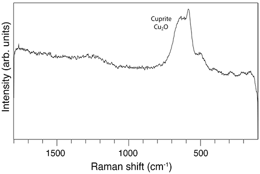
Raman spectroscopy was used to determine the mineralogy of blue-tinted oxide coatings on red-bed shales near measured section MS-4. Standard point Raman spectra were collected from this rock sample with a Renishaw inVia Reflex Raman Microprobe using a Peltier cooled charge-coupled device camera (1024 x 256 pixels). The Raman light was dispersed by a diffraction grating with 2,400 mm/line and analyzed at room temperature. Sample excitation was achieved with an argon ion laser emitting at a wavelength of 514.5 nm. The laser power impinging on the samples was between 1 and 5 mW to minimize laser-induced heating of samples. Spectra were collected with a x20 (0.40 numerical aperture) objective lens for four accumulations of 20 s. Calibration of the Raman shift is achieved by recording the Raman spectrum of the silicon F1g mode for one accumulation and 10 s. If necessary, an offset correction is performed to ensure that the position of the F1g band is at 520.50 ± 0.10 cm-1.
Detrital zircons from three bulk sandstone samples (fig. 5; POR1-2, POR3-1, POR4-1) were analyzed using laser ablation-inductively coupled plasma-mass spectrometry (LA-ICP-MS) at the Arizona Laser-Chron Center using methods described by Gehrels et al. (2006, 2008). Reported ages are best age estimates, i.e., when the average of the 238U/206Pb age and the 207Pb/206Pb age is more than 1 Ga, the 207Pb/206Pb age is reported. Ages less than 1 Ga are 238U/206Pb ages. Analytical results are presented using features available in Ludwig (2012) and the NORMALIZED PROB PLOT, OVERLAP-SIMILARITY PROGRAM, and AGE PICK Excel macros listed in the Analysis Tools section of the Arizona Laser-Chron Center webpage (www.laserchron.org). Maximum depositional ages are calculated using techniques outlined in Dickinson and Gehrels (2010) on the aggregated set of all detrital zircons sampled at Point of Rocks.
Five facies are recognized from the measured stratigraphic sections (fig. 5). The five facies are 1) fissile red beds, 2) structureless sandstone, 3) trough cross-bedded sandstone, 4) planar-laminated sandstone, and 5) mudstone clast conglomerate. We examined the outcrops for both body and trace fossils and, as with previous studies (Smith, 1940; Liggett and Zakrzewski, 1997; Liggett et al., 1998), none were found.
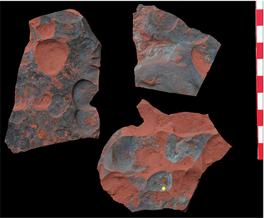
The fissile red beds facies is composed of thin beds of dark red (2.5YR 3/6) to reddish-brown (2.5YR 5/4), generally structureless, fissile siltstone interstratified with reddish-brown (2.5YR 5/4), very fine grained, feldspathic shale and sandstone (fig. 6A). This unit is laterally extensive and comprises the majority of strata in the study area, except in the area immediately below the Point of Rocks. Contacts with the overlying Ogallala are generally sharp, though in some areas horizontal and subvertical calcrete sheet cracks (2-20 cm thick) penetrate and accentuate bedding in the upper 2 m of the fissile red bed facies (fig. 6B). A thin blue varnish is present on many siltstone and shale partings in this facies (fig. 7). Raman spectra acquired in the mineral fingerprint region (100-1,800 cm-1) from the blue-colored material in hand samples shows two broad bands between 500 and 650 cm-1. Based on the modes predicted by group theory analysis for copper-oxide cuprite (Cu2O; Williams and Porto, 1973), these two distinctive broad bands are assigned to copper oxide (Cu2O) at 580 and 630 cm-1.
Figure 6--Field photos showing (A) fissile red beds facies in MS-4; (B) calcrete development at the unconformable contact in MS-2 between the Ogallala Formation (No) and the fissile red beds facies (frb); (C) the collection of the POR 4-1 sample for detrital zircon dating from a structureless sandstone interbedded with fissile siltstone facies; and (D) red mudstone rip-up clasts in a structureless sandstone bed near the base of MS-2.
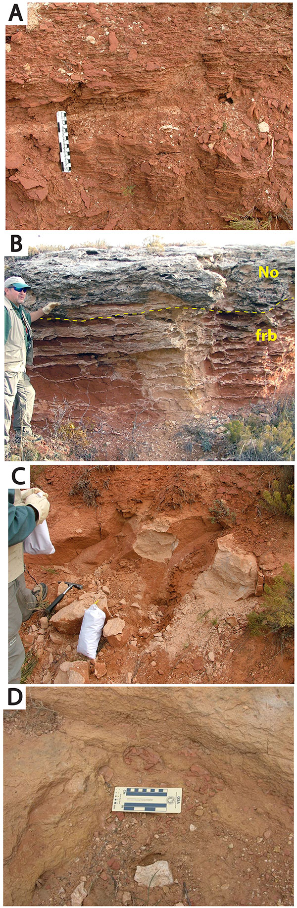
Figure 7--Red-bed siltstones from near MS-4 showing bluish varnish. Yellow dot shows where representative Raman spectra were collected. The spectrum shows two broad bands between 500 and 650 cm-1. These two distinctive broad bands are assigned to the triply degenerate Cu-O vibrational modes in the copper oxide lattice at 580 and 630 cm-1.
The structureless sandstone facies is composed of thin to thick beds of tan (10YR 8/3; weathers reddish brown to yellow), very fine to fine-grained, well-cemented, predominantly subrounded quartz sandstone (fig. 6C). Sedimentary structures are absent or only weakly expressed. Dark red (2.5YR 3/6) mudstone clasts up to 10 cm in diameter occur in this facies but are rare (fig. 6D). Structureless sandstone beds are commonly interbedded with fissile siltstone. This facies ranges from 0.5 to 1.5 m thick, though actual bed thicknesses for this facies in particular are obscured by intervals of fine-grained talus derived most likely from weathered siltstones.
Thick beds of trough cross-bedded sandstone are present in sections measured immediately underlying the Point of Rocks promontory (fig. 5; MS-1 and MS-3). This facies is composed of light gray (10YR 7/2) to tan (10YR 6/6), very fine to fine-grained, well-cemented, well-sorted quartz sandstone (fig. 8A). Cross-beds are approximately 1 cm thick and arranged in trough sets approximately 10 cm thick (fig. 8B). On weathered surfaces, calcareous cements may stand in positive relief as small knobby nodules or as thin (less than 1 cm) sheets along bedding planes and laminae. Trough axes are oriented in a roughly north-south direction with paleodrainage indicated toward the south.
Figure 8--Field photos showing (A) 4.5 m of sandstone and conglomeratic deposits at the top of MS-1 (scale bar in 1-foot increments); (B) trough cross-bedded sandstone at the top of MS-3; (C) mud-draped laminae suggesting neap-spring tidal modulation in MS-1; (D) a close-up of the planar-laminated sandstone facies showing very thin mud drapes; and (E) red beds rip-up clasts of mudstone clast conglomerate facies.
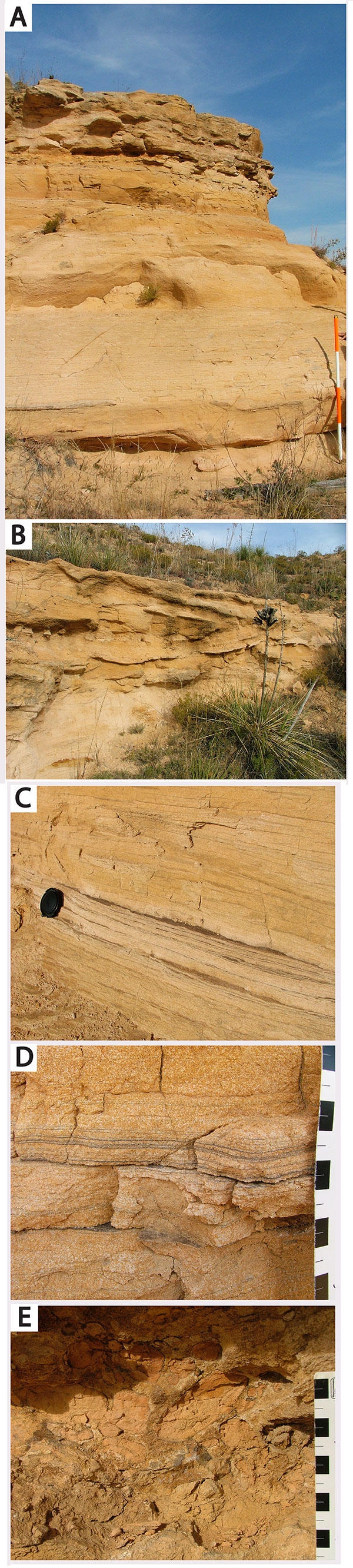
Planar-laminated sandstone facies are thin to thick beds of very light gray (10YR 7/1), poorly cemented, very fine grained, well-sorted quartz grains (fig. 8C). This facies is characterized throughout by very thin, planar to slightly wavy, mud-draped laminae. The mud drapes are dark gray to very faint, depending on thickness, but are generally less than 1 mm thick (fig. 8D). As with the trough cross-bedded sandstone facies, nodular and sheet-like protrusions of calcareous cement stand in positive relief on some weathered surfaces.
The mudstone clast conglomerate facies is present in the MS-1 and MS-3 measured sections (fig. 5). The conglomerate is a 5-30 cm thick bed of clast- and matrix-supported clasts within an indurated, sandy mudstone matrix (fig. 8E). Composed of reddish-brown (2.5YR 5/4) mudrock and claystone chips with an unordered fabric, clasts range from 1 to 10 cm on their long axes. The upper and lower contacts are undulatory while the latter appears to scour into the underlying planar-laminated sandstone facies.
Detrital zircon age-probability plots for the three samples (fig. 9; raw DZ data included in Appendix 1) show a series of peaks or groups of peaks that define at least seven major zircon generating events on the North American continent (e.g., Dickinson and Gehrels, 2003, 2008, 2009; Soreghan and Soreghan, 2013). The oldest of these are Archean grains (more than 2,500 Ma) presumably from Laurentian cratons in the northern interior of the continent (fig. 10). Paleoproterozoic grains in North American strata are frequently associated with the Wopmay (2,300-1,800 Ma) and Yavapai-Mazatzal (1,800-1,535 Ma) orogens, though similar-aged zircons in Pennsylvanian rocks of the Appalachian Basin may have been derived from age-correlative events on the Gondwanan margin (Thomas et al., 2004). Mesoproterozoic grains are the most abundant DZ population (36.36% of all grains) and are attributed primarily to two sources: midcontinental anorogenic granites and rhyolites exposed during the Paleozoic in the Ancestral Rocky Mountains (1,535-1,300 Ma) and grains produced during the Grenville orogeny (1,300-905 Ma). Late Neoproterozoic grains are also abundant (32.52% of total) and are likely a mix of peri-Gondwanan terranes (750-510 Ma) uplifted and deposited along with Paleozoic zircons (510-285 Ma) during the Appalachian-Ouachita orogens along the east-southeastern margins of North America.
Figure 9--Age-distribution curves of detrital zircon ages from three bulk samples (POR 1-2, POR 3-1, and POR 4-1). Color swaths highlight seven significant igneous provinces and events (modified from Dickinson and Gehrels, 2009) that likely contributed to DZ populations of Point of Rocks samples; n = number of zircon grains sampled.
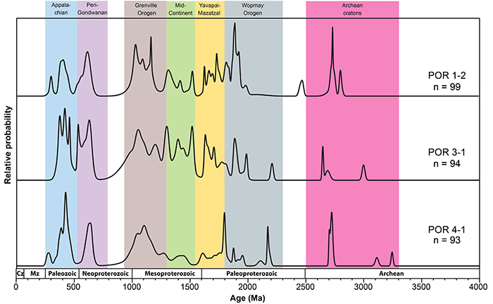
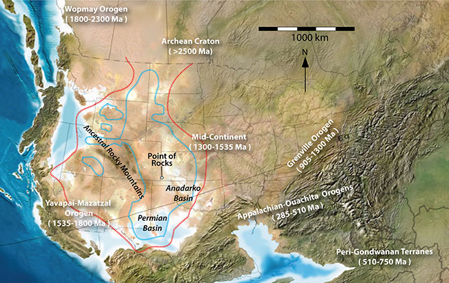
Figure 10--Paleogeographic map of North America for the Guadalupian series (~260 Ma; Blakey, 2013) showing distribution of Permian red beds (red dashed line) and evaporites (blue dashed lines) and the provinces and ages of basement rocks supplying detrital zircons to strata in North America (red bed and evaporite outlines modified from Walker, 1967; provenance data from Dickinson and Gehrels, 2009).
We interpret strata underlying the Ogallala Formation at Point of Rocks as overbank and tidally influenced fluvial deposits. The interbedded fissile red beds and structureless sandstone facies are interpreted as fine-grained overbank deposits (fig. 5, MS-2 and MS-4). Their general absence of primary sedimentary structures and red coloring suggest subaerial exposure and weak paleopedogenic modification. Structureless sandstones in these sections are interpreted as tabular sheet sands resulting from crevasse splays and rapid suspension deposition during floods. These units contain a higher fraction of clay- and silt-sized particles and are more erosive than the sandstones in the central measured sections. Copper oxides along parting laminations and fractures suggest that the exposed red beds once hosted copper sulfides. Copper-bearing sedimentary deposits, while rare in Jurassic or Cretaceous units, are abundant in both Permian and Triassic red-bed deposits in North America (Kirkham, 1989). In fact, some Permian red beds are an economically viable source of copper ore (Lambert et al., 1981). Copper-bearing minerals in Permian red beds include such sulfides as chalcocite (Cu2S) and chalcopyrite (CuFeS2) and carbonates such as malachite (CuCO3Cu[OH]2) (e.g., Johnson, 1974; Fay, 1975). Because sulfide minerals are unstable in oxidizing weathering environments, the cuprite likely formed as a product of recent weathering (fig. 7).
Resistant beds of trough cross-bedded sandstone crop out directly below the Point of Rocks and protrude southward from the bluff (fig. 5; MS-1 and MS-3). We interpret these sandstones to be fluvial and tidally influenced channel belt sandstones, incised into the red alluvial plain mudrocks. Tidal influences in the channel deposits are indicated by the thin mud drapes in planar-laminated sandstones, which suggest tidal modulation and neap-spring cyclicity (fig. 8C-D). In modern river systems such as the Amazon, tidal currents induce up to m-scale changes in water level several hundred kilometers from the coast and influence flow as far as 800 km inland (Kvale and Archer, 2007). A prominent intraformational mud-chip conglomerate that contains red-bed clasts and scours into the probable tidal laminites is overlain by several meters of trough cross-bedded sandstones--apparently separating two stories in the channel. A structureless sandstone unit is also present within the channel fill (fig. 5, MS-1). Such structureless channel deposits may have resulted from bank collapse or liquefaction and flow of channel bars (Reading, 1996). In the lowermost channel sandstone unit, trough cross-beds indicating a southern paleoflow direction are well exposed in plain view.
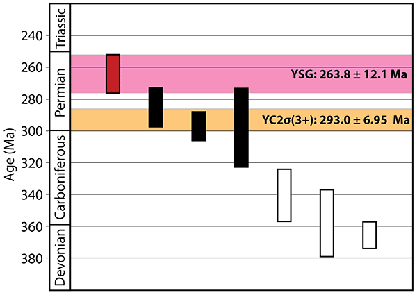
There are several methods for using the youngest uranium-lead ages of detrital zircons to constrain the maximum depositional age (MDA) of sedimentary units (Dickinson and Gehrels, 2010). One such method, YC2σ(3+), is the weighted mean age of the youngest grouping of three or more grains overlapping in uranium-lead age at 2σ. Based on the aggregated dataset of all three DZ samples, the mean age YC2σ(3+) of Point of Rocks strata is 293 ± 6.95 Ma (fig. 11). Although YC2σ(3+) is a statistically robust measure of MDA, Dickinson and Gehrels (2010) in a study of Colorado Plateau sandstones with biostratigraphically controlled Mesozoic depositional ages found that YC2σ(3+) was also highly conservative and tended to be more than 10 m.y. older than accepted depositional age in the majority of cases. The youngest single grain (YSG) age at 1σ in a DZ population, however, was found to be within the accepted age range of the deposit in more than 90% of the samples and within 5 million years of depositional age for 95% or more of the sandstones. The YSG age produced from Point of Rocks DZ grain samples is 263.8 ± 12.1 Ma from sample POR 4-1. Significantly, both the YSG age and the conservative YC2σ(3+) suggest Permian maximum depositional ages.
Figure 11--Maximum depositional ages calculated from the seven youngest uranium-lead ages at 2σ (vertical bars) for the aggregated dataset of all Point of Rocks DZ ages. YSG: youngest single grain (red bar and pink stripe highlighting 2σ); YC2σ(3+): the weighted mean age of the three youngest overlapping detrital zircon ages at 2σ (three black bars and orange stripe highlighting 2σ).
Further refinement of maximum depositional age can be achieved through comparison of the Point of Rocks data with DZ age data from other late Paleozoic and Mesozoic units in the central and western United States (fig. 12). Detrital zircon ages of Point of Rocks strata show high degrees of overlap (0.89) and similarity (0.87) with such late Permian units as the Guadalupian Brushy Canyon and Bell Canyon Formations of the Delaware Mountain Group in the greater Permian Basin of New Mexico-West Texas (Soreghan and Soreghan, 2013). In comparison to the vertical succession of Permian strata sampled from the Grand Canyon, the youngest Point of Rocks ages are most similar to the youngest 270-360 Ma peaks of the Permian Kaibab Formation (Gehrels et al., 2011). The youngest Point of Rocks DZ ages are also comparable to, though younger than, the youngest 300-450 Ma population of DZ data from the middle Permian Flower-pot Shale and Blaine Formation of western Oklahoma (Sweet et al., 2013). These youngest DZ grains in Permian deposits were likely derived from Appalachian-Ouachita (285-510 Ma) orogenic sources along the east-southeastern margins of North America (fig. 10).
Figure 12--Normalized age-distribution curves of uranium-lead dates of detrital zircon from aggregated samples of Permian (Soreghan and Soreghan, 2013), Triassic (Dickinson and Gehrels, 2008), Jurassic (May et al., 2013), and Cretaceous (Finzel, 2014) formations and a composite of all zircon samples from the Point of Rocks; n = number of zircon grains analyzed.
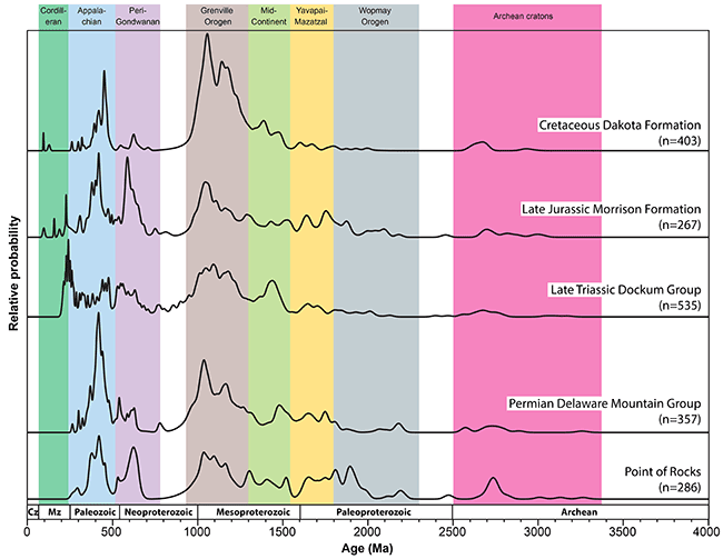
The youngest peaks of the Middle Triassic Moenkopi Formation, Chinle Formation, and Dockum Group, in contrast, are typically between ~200 and 285 Ma (Dickinson and Gehrels, 2008, 2010). Source areas for these youngest DZ populations likely included the Cordilleran magmatic arc (220-245 Ma) of western North America and the Ouachita foreland of Texas and northwest Mexico (Dickinson and Gehrels, 2009). Midcontinental Jurassic deposits such as the Sundance and Morrison Formations and the Cretaceous Dakota Formation typically exhibit young DZ ages in the 90-200 Ma range primarily from Cordilleran orogenic sources (Blum and Pecha, 2014; May et al., 2013; Finzel, 2014).
The similarity among the age spectra of all three DZ samples suggests that the episodes of deposition and incision occurred relatively rapidly, with no particularly extensive unconformities represented. Of course, a lag between zircon crystallization and deposition is common, which does not eliminate the possibility that the depositional age may be up to tens of millions of years younger than the youngest zircons (Gehrels et al., 2011). A lack of Mesozoic zircons in the red-bed and sandstone units exposed at Point of Rocks indicates a Permian maximum depositional age.
Permian paleogeography on the North American midcontinent is in large part the story of shallow inland seas giving way to evaporite deposits and eolian environments following the assembly of Pangaea and a major global marine lowstand (fig. 10; West et al., 2010). At this time, the midcontinent was blanketed by sediments shed from the block-faulted Ancestral Rocky Mountains to the west and the Himalayan-sized Appalachian-Ouachita orogens to the east and southeast (Hatcher, 1987; Scotese and Langford, 1995). The area comprising modern Kansas was a complex patchwork of shallow marine and coastal environments on a broad ramp that sloped southward toward the Anadarko and Permian basins (West et al., 2010). Kansas was in an equatorial position during the Permian with a tropical to dry subtropical climate (Ziegler et al., 1998). By the late Permian, the shallow inland seas withdrew entirely to the south leaving extensive evaporite deposits and widespread eolian and fluvial red-bed landscapes (e.g., Benison and Goldstein, 2001; Zambito et al., 2012; Benison et al., 2013; Benison et al., 2015).
During the Triassic, midcontinent landscapes were erosional uplands and sedimentation had shifted west along the Chinle-Dockum paleodrainage systems of the Colorado Plateau and southern High Plains of Texas and New Mexico (Dickinson and Gehrels, 2008), so that no Triassic deposits are currently recognized in Kansas from outcrop or core (West et al., 2010). Though rocks of the Jurassic System were deposited over the western third of Kansas (Zeller, 1968), they are little studied because they are (as proposed in this study) encountered only in the subsurface. In Kansas, the Upper Jurassic Morrison Formation described from core is chiefly composed of gray to greenish-gray fine sandstones, siltstones, and calcareous mudrocks containing gypsum and anhydrite (Joeckel et al., 2007). The vast majority of Mesozoic rocks in Kansas were deposited during the mid- to late Cretaceous Period while North America was again inundated by a large inland sea (Zeller, 1968). These rocks are mostly marine shales and carbonates, though the Cheyenne Sandstone and Dakota Formation at the base of the Cretaceous succession are predominantly fluvial sandstones and paleosols are common (Ludvigson et al., 2010; Retallack and Dilcher, 2012). Red beds are not reported from Jurassic or Cretaceous strata in Kansas.
Our interpretation of the depositional system at Point of Rocks is generally consistent with the Permian paleogeographic reconstructions in the midcontinent. Alluvial red-bed deposits are common in Permian strata throughout the region. Channel sandstones with north-south orientations and tidally influenced sedimentary structures are reasonable given the proximity of shallow seas to the south. Triassic rocks are seemingly missing entirely from Kansas, while Jurassic and Cretaceous strata in Kansas are lithologically distinct from rocks described at Point of Rocks.
Assigning a geologic age to red beds at Point of Rocks has been complicated by the lack of observed fossils, a mix of previously unrecognized contrasting facies, and poor exposures. The DZ data presented here suggest correlation of these strata with one of the many red-bed successions in the Permian System. The uppermost Permian unit in Kansas is the Guadalupian Big Basin Formation (Zeller, 1968), referred to as the Taloga Formation in much of the older literature. The formation is characterized by red silty mudrocks and fine-grained red silty sandstones with some anhydrite and dolomite (West et al., 2010). O'Connor (1963) abandoned the name Taloga Formation in Kansas and reinstated the name Big Basin Formation used by Norton (1939) for all rocks between the Day Creek Dolomite and the top of the Permian unconformity. The Day Creek Dolomite is a fine-grained dolomite interbedded with red mudrocks and anhydrite and is mostly anhydrite at its thickest (~36 m) in the subsurface (Swineford, 1955). The Day Creek Dolomite is recognized as a reliable stratigraphic marker bed at the surface and in the subsurface (Norton, 1939). Norton (1939) reported approximately 19.8 m of Big Basin Formation (top of the Day Creek Dolomite to the base of the Cretaceous Kiowa Formation) in south-central Kansas and reported no fossils in the formation. Moore et al. (1951) noted that the maximum exposed thickness of the Big Basin Formation in Kansas was about 13.7 m at an outcrop area restricted to Clark and Meade counties east of Point of Rocks. Reported subsurface thicknesses range from ~48 m to more than 122 m (Edson, 1947; Merriam, 1963; Gutentag et al., 1981). Foster et al. (2014) identified the first magnetostratigraphic reversal of the Kiaman superchron (~267 Ma) in eolian deposits at the boundary between the middle Permian Dog Creek and Whitehorse Formations underlying the Day Creek Dolomite. These findings would support a maximum depositional age for the Big Basin Formation within the range of our YSG age (263.8 ± 12.1 Ma).
Red beds and sandstones were reported at shallow depths in three boreholes drilled within 5 km of the Point of Rocks study area (fig. 3 and fig. 13). The first was test hole 8 described by McLaughlin (1942). Note that the location reported for test hole 8 (NE sec. 12, T 34 S, R 43 W) places it in the uplands above the Ogallala outcrop to the east of Point of Rocks and about 30.5 m higher than the reported elevation. Based on the reported elevation (1,044.7 m) and the amount of alluvium logged (3.6 m), the correct location of test hole 8 is probably NE SE sec. 12 in the floodplain at the base of the exposure. There, McLaughlin (1942) reported interbedded red sandstone and siltstone to a depth of ~47 m underlain by ~14 m of maroon siltstone and gypsum to the bottom (61 m) of the hole. The second borehole was an Emergency Export Co. oil and gas test approximately 1.46 km northwest of Point of Rocks (Maher and Collins, 1952). Logs for that hole show red shaly sandstone from the base of the Ogallala unconformity to a depth of ~66 m underlain by ~14 m of dolomite, reddish-brown shale, and anhydrite. The third was a 20-m borehole drilled by the Kansas Department of Transportation (KDOT) approximately 4.2 km northeast of Point of Rocks along Kansas Highway 27. Logs for that hole showed ~15 m of red shaly sandstone below ~5 m of Cimarron River alluvium (Croxton et al., 1998).
Figure 13--Composite cross section A-A' (fig. 2) showing measured sections (MS-1 to MS-4) and subsurface data from nearby tests (McLaughlin, 1942; Maher and Collins, 1952; and Croxton et al., 1998). Depths are marked in meters below sea level. Not to scale horizontally.
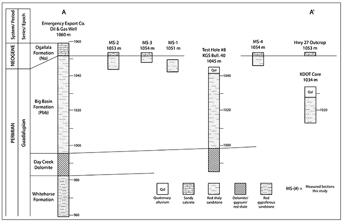
The ~14 m thick gypsum- or anhydrite-rich, dolomitic, shaly unit encountered in the Emergency Export Co. oil and gas test (Maher and Collins, 1952) and test hole 8 (see Sawin, 2015) have been interpreted as the regional Day Creek Dolomite marker bed (fig. 13). Thus, we assign overlying red-bed units observed in drillers' logs and the outcrop at Point of Rocks to the Guadalupian Big Basin Formation. This interpretation is consistent with the subsurface data and the detrital zircon data collected from the measured sections.
Uranium-lead dating of detrital zircons was applied to samples of exposed non-fossiliferous strata underlying the Ogallala Formation at Point of Rocks in Morton County, Kansas, to better constrain the depositional age of the rocks. Red beds composed of fissile shale and sandstone are interpreted as alluvial overbank deposits, while dominantly trough cross-bedded and planar-laminated sandstones are interpreted as tidally influenced fluvial channel deposits. The channel sandstones are better cemented and more resistant to weathering than the red beds and defended the overlying escarpment of the Ogallala Formation from erosional retreat along the north bluff line of the Cimarron River valley.
Age spectra of the DZ samples from the site can be grouped into at least seven subpopulations with a youngest single zircon age of 263.8 ± 12.1 Ma and a more conservative YC2σ(3+) age of 293.0 ± 6.95 Ma. These ages suggest that the red beds were deposited in the Permian. Comparisons to DZ age spectra from other Permian units in western North America and a lack of Mesozoic-aged zircons support this interpretation. Copper oxides along partings and fractures suggest that Point of Rocks once hosted copper sulfides. Copper sulfides are common in regional Permian-Triassic red beds. We reject previous interpretations of Triassic, Jurassic, or Cretaceous ages for the red-bed strata at Point of Rocks. The DZ data, in conjunction with the likely identification of the Day Creek Dolomite marker bed in logs of nearby drilling operations, strongly suggest that the enigmatic strata cropping out at the base of Point of Rocks are Permian red beds of the Guadalupian Big Basin Formation.
The authors thank Dr. George Gehrels and Roswell Juan of the Arizona LaserChron Center. We also thank District Ranger Joe Hartman and USDA Forest Service staff at the Cimarron National Grassland. We thank Drs. Kathleen Benison and Michael Blum for their technical reviews and thoughtful critiques of the manuscript. Cathy Evans (KGS) improved the clarity of the manuscript and for that we are grateful, and we thank Julie Tollefson (KGS) for editorial handling and publication assistance.
Benison, K. C., and Goldstein, R. H., 2001, Evaporites and siliciclastics of the Permian Nippewalla Group, Kansas and Oklahoma: A case for nonmarine deposition: Sedimentology, v. 48, p. 165-188.
Benison, K. C., Zambito, J. J., and Knapp, J. P., 2015, Contrasting siliciclastic-evaporite strata in subsurface and outcrop: An example from the Permian Nippewalla Group of Kansas, U.S.A.: Journal of Sedimentary Research, v. 85, p. 626-645.
Benison, K. C., Zambito, J. J., Soreghan, G. S., Soreghan, M. J., Foster, T. M., and Kane, M. J., 2013, Permian red beds and evaporites of the Amoco Rebecca K. Bounds core, Greeley County, Kansas: Implications for science and industry; in, Midcontinent core workshop: From source to reservoir to seal, Midcontinent Section American Association of Petroleum Geologists, M. K. Dubois, W. L. Watney, and J. Tollefson, eds.: Midcontinent Core Workshop: From Source to Reservoir to Seal, Midcontinent Section American Association of Petroleum Geologists, Kansas Geological Survey and Kansas Geological Society, Wichita, Kansas, p. 9-14.
Blakey, R. C., 2013, Paleogeographic and tectonic history of North America--Key time slices: Colorado Plateau Geosystems, Inc., http://cpgeosystems.com/namkeypaleogeography.html (accessed August 15, 2015).
Blum, M., and Pecha, M., 2014, Mid-Cretaceous to Paleocene North American drainage reorganization from detrital zircons: Geology, v. 42, no. 7, p. 607-610.
Croxton, N. M., Geist, J. W., and Peterson, A. E., 1998, Bridge foundation geology report, K-27 over the Cimarron River, Morton County, Kansas: Kansas Department of Transportation, Topeka, Kansas, 9 p.
Dickinson, W. R., and Gehrels, G. E., 2003, U-Pb ages of detrital zircons from Permian and Jurassic eolian sandstones of the Colorado Plateau, USA: Paleogeographic implications: Sedimentary Geology, v. 163, p. 29-66.
Dickinson, W. R., and Gehrels, G. E., 2008, U-Pb ages of detrital zircons in relation to paleogeography: Triassic paleodrainage networks and sediment dispersal across southwest Laurentia: Journal of Sedimentary Research, v. 78, p. 745-764.
Dickinson, W. R., and Gehrels, G. E., 2009, Use of U-Pb ages of detrital zircons to infer maximum depositional ages of strata: A test against a Colorado Plateau Mesozoic database: Earth and Planetary Science Letters, v. 288, p. 115-125.
Dickinson, W. R., and Gehrels, G. E., 2010, Insights into North American paleogeography and paleotectonics from U-Pb ages of detrital zircons in Mesozoic strata of the Colorado Plateau, USA: International Journal of Earth Sciences, v. 99, p. 1,247-1,265.
Dickinson, W. R., Gehrels, G. E., and Marzolf, J. E., 2010, Detrital zircons from fluvial Jurassic strata of the Michigan basin: Implications for the transcontinental Jurassic paleoriver hypothesis: Geology, v. 38, p. 499-502.
Edson, F. C., 1947, Subsurface geologic cross section from Ford County, Kansas, to Dallam County, Texas: Kansas Geological Survey, Oil and Gas Investigations, Preliminary Cross Section No. 3.
Fay, R. O., 1975, A possible origin for copper in Oklahoma: Oklahoma Geology Notes, v. 35, no. 4, p. 151-153.
Finzel, E. S., 2014, Detrital zircons from Cretaceous midcontinent strata reveal an Appalachian Mountains-Cordilleran foreland basin connection: Lithosphere, v. 6, no. 5, p. 378-382.
Foster, T., Soreghan, G. S., Soreghan, M. J., Benison, K. C., and Elmore, R. D., 2014, Climatic and palaeogeographic significance of aeolian sediment in the middle Permian Dog Creek Shale (Midcontinent U.S.): Palaeogeography, Palaeoclimatology, Palaeoecology, v. 402, p. 12-29.
Gehrels, G. E., 2012, Detrital zircon U-Pb geochronology: Current methods and new opportunities; in, Tectonics of sedimentary basins: Recent advances, C. Busby and A. A. Perez, eds.: Hoboken, New Jersey, Wiley-Blackwell, p. 47-62.
Gehrels, G. E., Blakey, R., Karlstrom, K. E., Timmons, J. M., Dickinson, B., and Pecha, M., 2011, Detrital zircon U-Pb geochronology of Paleozoic strata in the Grand Canyon, Arizona: Lithosphere, v. 3, p. 183-200.
Gehrels, G. E., Valencia, V., and Pullen, A., 2006, Detrital zircon geochronology by laser-ablation multicollector ICPMS at the Arizona LaserChron Center; in, Geochronology: Emerging opportunities, Paleontology Society short course, T. Loszewski and W. Huff, eds.: Paleontology Society Papers, v. 11, 10 p.
Gehrels, G. E., Valencia, V., and Ruiz, J., 2008, Enhanced precision, accuracy, efficiency, and spatial resolution of U-Pb ages by laser ablation-multicollector-inductively coupled plasma-mass spectrometry: Geochemistry Geophysics Geosystems, v. 9, Q03017, doi:10.1029/2007GC001805.
Gould, C. N., 1901, The Dakota Cretaceous of Kansas and Nebraska: Kansas Academy of Science Transactions, v. 17, p. 122-178.
Gutentag, E. D., Lobmeyer, D. H., and Slagle, S. E., 1981, Geohydrology of southwestern Kansas: Kansas Geological Survey, Irrigation Series 7, 73 p. [available online]
Hatcher, R. D., Jr., 1987, Tectonics of the southern and central Appalachian internides: Annual Review of Earth and Planetary Sciences, v. 15, p. 337-362.
Joeckel, R. M., Ludvigson, G. A., Wally, K. D., and Doveton, J. H., 2007, Preliminary analysis of the Upper Jurassic Morrison Formation in the Rebecca Bounds Core, western Kansas: Geological Society of America Abstracts with Programs, v. 39, no. 6, p. 338.
Johnson, K. S., 1974, Permian copper shales of Southwestern United States; in, Gisements stratiforme et provinces cuprifères, P. Bartholomé, ed.: Société Geologique de Belgique, p. 383-393.
Johnson, W. C., Woodburn, T. L., and Messinger, L. G., 2009, Surficial geology of Morton County, Kansas: Kansas Geological Survey, Map M-116, 1 sheet, 47 x 38 inches, scale 1:50,000. [available online]
Kansas Geological Survey, 1991, Geologic Map of Kansas: Kansas Geological Survey, Map M-23, 1:500,000 scale.
Kirkham, R. V., 1989, Distribution, settings, and genesis of sediment-hosted stratiform copper deposits; in, Sediment-hosted stratiform copper deposits, R. W. Boyle, A. C. Brown, C. W. Jefferson, E. C. Jowett, and R. V. Kirkham, eds.: Geological Association of Canada Special Paper 36, p. 3-38.
Kume, J., and Spinazola, J. M., 1985, Geohydrology of sandstone aquifers in southwestern Kansas: Kansas Geological Survey, Irrigation Series 8, 49 p. [available online]
Kvale, E. P., and Archer, A. W., 2007, Paleovalley fills--Trunk vs. tributary: American Association of Petroleum Geologists, Bulletin, v. 91, no. 6, p. 809-821.
Lambert, M. W., Berenden, P., and Ripley, E. M., 1981, Copper sulfides in the Lower Permian redbeds of south-central Kansas: Kansas Geological Survey, Bulletin 223, part 2. [available online]
Liggett, G. A., and Zakrzewski, R. J., 1997 (revised 1998), Final report on the geological and paleontologic investigation of the Cimarron National Grassland: Fort Hays State University and U.S. Department of Agriculture Forest Service contract #CC2-2-12-94-07-028, 29 p.
Liggett, G. A., Zakrzewski, R. J., and McNinch, K. L., 1998, Geologic and paleontologic investigation of the Cimarron National Grassland, Morton County, Kansas: Dakoterra, v. 5, p. 123-126.
Ludvigson, G. A., Witzke, B. J., Joeckel, R. M., Ravn, R. L., Phillips, P. L., González, L. A., and Brenner, R. L., 2010, New insights on the sequence stratigraphic architecture of the Dakota Formation in Kansas-Nebraska-Iowa from a decade of sponsored research activity: Kansas Geological Survey, Current Research in Earth Sciences, Bulletin 258, part 2. [available online]
Ludwig, K. R., 2012, Isoplot 3.75: A geochronological toolkit for Microsoft Excel: Berkeley Geochronology Center Special Publication No. 5, revised January 30, 2012. [information online]
Maher, J. C., and Collins, J. B., 1952, Correlation of Permian and Pennsylvanian rocks of western Kansas to the Front Range of Colorado: U.S. Geological Survey, Oil and Gas Investigations, Chart OC-46, 3 sheets. [available online].
May, S. R., Gray, G. G., Summa, L. L., Stewart, N. R., Gehrels, G. E., and Pecha, M. E., 2013, Detrital zircon geochronology from the Bighorn Basin, Wyoming, USA: Implications for tectonostratigraphic evolution and paleogeography: Geological Society of America Bulletin, v. 125, p. 1,403-1,422.
McLaughlin, T. G., 1942, Geology and ground-water resources of Morton County, Kansas: Kansas Geological Survey, Bulletin 40, 126 p. [available online]
McNinch, K. L., 1996, An integrated GIS database, geologic and paleontologic reconnaissance, and areal correlation of soils to geology within Cimarron National Grasslands (sic), Morton County, Kansas: M.S., Fort Hays State University, 99 p.
Merriam, D. F., 1963, The geologic history of Kansas: Kansas Geological Survey, Bulletin 162, 317 p. [available online]
Moore, R. C., Frye, J. C., and Jewett, J. M., 1944, Tabular description of outcropping rocks in Kansas: Kansas Geological Survey, Bulletin 52, part 4, p. 137-212. [available online]
Moore, R. C., Frye, J. C., Jewett, J. M., Lee, W., and O'Connor, H. G., 1951, The Kansas rock column: Kansas Geological Survey, Bulletin 89, 132 p. [available online]
Moore, R. C., Frye, J. C., Jewett, J. M., Lee, W., and O'Connor, H. G., 1952, Graphic column of Kansas rocks: Kansas Geological Survey, 1 sheet.
Moore, R. C., and Landes, K. K., 1937, Geologic map of Kansas: Kansas Geological Survey, scale 1:500,000.
Munsell Color, 2000, Munsell Soil Color Chart, Baltimore, Maryland, 22 p.
Norton, G. H., 1939, Permian redbeds in Kansas: American Association of Petroleum Geologists, Bulletin, v. 23, no. 12, p. 1,751-1,815.
O'Connor, H. G., 1963, Changes in Kansas stratigraphic nomenclature: American Association of Petroleum Geologists, Bulletin, v. 47, no. 10, p. 1,873-1,877.
Reading, H. G., 1996, Sedimentary environments: Processes, facies and stratigraphy, 3rd edition. Oxford, Blackwell Science, 688 p.
Retallack, G. J., and Dilcher, D. L., 2012, Outcrop versus core and geophysical log interpretation of mid-Cretaceous paleosols from the Dakota Formation of Kansas: Palaeogeography, Palaeoclimatology, Palaeoecology, v. 329, p. 47-63.
Sawin, R. S., 2015, Copies of archived correspondence pertinent to the decision to classify the exposure at Point of Rocks, Morton County, Kansas, as Jurassic by the Kansas Geological Survey in 1967: Kansas Geological Survey, Open-File Report 2015-2, 11 p. [available online]
Scotese, C. R., and Langford, R. P., 1995, Pangea and the paleogeography of the Permian; in, The Permian of Northern Pangea, vol. 1, P. A. Scholle, T. M. Peryt, and D. S. Ilmer-Scholle, eds.: Berlin, Springer-Verlag, p. 3-19.
Smith, H. T. U., 1940, Geological studies in southwestern Kansas: Kansas Geological Survey, Bulletin 34, 212 p. [available online]
Soreghan, G. S., and Soreghan, M. J., 2013, Tracing clastic delivery to the Permian Delaware Basin, USA: Implications for paleogeography and circulation in westernmost equatorial Pangea: Journal of Sedimentary Research, v. 83, p. 786-802.
Sweet, A. C., Soreghan, G. S., Sweet, D. E., Soreghan, M. J., and Madden, A. S., 2013, Permian dust in Oklahoma: Source and origin for Middle Permian (Flowerpot-Blaine) redbeds in western tropical Pangaea: Sedimentary Geology, v. 284-285, p. 181-196.
Swineford, A., 1955, Petrography of Upper Permian rocks in south-central Kansas: Kansas Geological Survey, Bulletin 111, 179 p. [available online]
Thomas, W. A., Becker, T. P., Samson, S. D., and Hamilton, M. A., 2004, Detrital zircon evidence of a recycled orogenic foreland provenance for Alleghenian clastic-wedge sandstones: Journal of Geology, v. 112, p. 23-37.
Walker, T. R., 1967, Formation of red beds in modern and ancient deserts: Bulletin of the Geological Society of America, v. 78, p. 353-368.
West, R. R., Miller, K. B., and Watney, W. L., 2010, The Permian System in Kansas: Kansas Geological Survey, Bulletin 257, 82 p. [available online]
Williams, P. F., and Porto, S. P. S., 1973, Symmetry-forbidden resonant Raman scattering in Cu2O: Physical Review B 4, p. 1,782-1,785.
Zambito, J. J., Benison, K. C., Foster, T., Soreghan, G. S. Kane, M., and Soreghan, M. J., 2012, Lithostratigraphy of the Permian red beds and evaporites in the Rebecca K. Bounds, Core, Greeley County, Kansas: Kansas Geological Survey, Open-File Report 2012-15, 45 p. [available online]
Zeller, D. E., ed., 1968, The stratigraphic succession in Kansas: Kansas Geological Survey, Bulletin 189, 81 p., 1 plate. [available online]
Ziegler, A. M., Gibbs, M. T., and Hulver, M. L., 1998, A mini-atlas of oceanic water masses in the Permian Period: Proceedings of the Royal Society of Victoria, v. 110, no. 1/2, p. 323-343.
| Isotope ratios | Apparent ages (Ma) | Best age | |||||||||||||||||
|---|---|---|---|---|---|---|---|---|---|---|---|---|---|---|---|---|---|---|---|
| Analysis | U (ppm) |
206Pb / 204Pb |
U/Th | 206Pb* / 207Pb* |
± (%) |
207Pb* / 235U* |
± (%) |
206Pb* / 238U |
± (%) |
error corr. |
206Pb* / 238U* |
± (Ma) |
207Pb* / 235U |
± (Ma) |
206Pb* / 207Pb* |
± (Ma) |
(Ma) | ± (Ma) |
Conc (%) |
| POR1-2 - 4 | 137 | 3839 | 0.9 | 18.6657 | 15.8 | 0.3480 | 16.1 | 0.0471 | 3.1 | 0.19 | 296.8 | 9.0 | 303.2 | 42.2 | 353.2 | 358.5 | 296.8 | 9.0 | NA |
| POR1-2 - 78 | 773 | 1715 | 0.6 | 17.5510 | 4.5 | 0.3712 | 9.7 | 0.0473 | 8.5 | 0.88 | 297.6 | 24.8 | 320.5 | 26.6 | 490.6 | 99.8 | 297.6 | 24.8 | NA |
| POR1-2 - 73 | 112 | 10332 | 1.0 | 18.2987 | 9.0 | 0.4489 | 9.7 | 0.0596 | 3.7 | 0.38 | 373.0 | 13.4 | 376.5 | 30.6 | 397.9 | 202.1 | 373.0 | 13.4 | NA |
| POR1-2 - 8 | 754 | 6184 | 39.2 | 17.8793 | 2.7 | 0.4621 | 4.2 | 0.0599 | 3.1 | 0.75 | 375.2 | 11.4 | 385.7 | 13.3 | 449.6 | 60.7 | 375.2 | 11.4 | NA |
| POR1-2 - 63 | 225 | 37556 | 2.6 | 18.0318 | 6.4 | 0.4803 | 7.3 | 0.0628 | 3.7 | 0.50 | 392.7 | 13.9 | 398.3 | 24.2 | 430.7 | 141.7 | 392.7 | 13.9 | NA |
| POR1-2 - 5 | 493 | 2394 | 3.0 | 17.6539 | 3.4 | 0.4994 | 6.1 | 0.0639 | 5.1 | 0.84 | 399.5 | 19.8 | 411.3 | 20.7 | 477.7 | 74.3 | 399.5 | 19.8 | NA |
| POR1-2 - 54 | 53 | 5977 | 2.4 | 18.5763 | 24.7 | 0.4810 | 26.1 | 0.0648 | 8.4 | 0.32 | 404.8 | 33.1 | 398.8 | 86.2 | 364.0 | 564.0 | 404.8 | 33.1 | NA |
| POR1-2 - 49 | 193 | 30889 | 5.3 | 18.1014 | 6.1 | 0.4954 | 6.8 | 0.0650 | 3.2 | 0.47 | 406.2 | 12.5 | 408.6 | 23.0 | 422.1 | 135.3 | 406.2 | 12.5 | NA |
| POR1-2 - 7 | 130 | 39051 | 1.6 | 16.7893 | 4.3 | 0.5491 | 5.9 | 0.0669 | 4.2 | 0.70 | 417.2 | 16.8 | 444.4 | 21.4 | 587.7 | 92.4 | 417.2 | 16.8 | 71.0 |
| POR1-2 - 87 | 364 | 56798 | 1.1 | 17.9709 | 2.3 | 0.5415 | 3.9 | 0.0706 | 3.1 | 0.81 | 439.7 | 13.3 | 439.4 | 13.8 | 438.2 | 50.9 | 439.7 | 13.3 | NA |
| POR1-2 - 43 | 67 | 15379 | 0.7 | 17.8339 | 15.4 | 0.5542 | 16.8 | 0.0717 | 6.8 | 0.40 | 446.3 | 29.3 | 447.8 | 61.0 | 455.3 | 343.4 | 446.3 | 29.3 | NA |
| POR1-2 - 80 | 177 | 53419 | 2.3 | 17.1622 | 2.0 | 0.6785 | 3.6 | 0.0845 | 2.9 | 0.83 | 522.6 | 14.8 | 525.9 | 14.6 | 539.9 | 43.5 | 522.6 | 14.8 | 96.8 |
| POR1-2 - 20 | 84 | 51272 | 1.2 | 16.5121 | 7.7 | 0.7510 | 8.5 | 0.0899 | 3.7 | 0.44 | 555.1 | 19.8 | 568.8 | 37.2 | 623.7 | 166.0 | 555.1 | 19.8 | 89.0 |
| POR1-2 - 42 | 221 | 47071 | 1.4 | 16.8689 | 2.7 | 0.7366 | 3.9 | 0.0901 | 2.7 | 0.70 | 556.2 | 14.5 | 560.4 | 16.6 | 577.4 | 59.7 | 556.2 | 14.5 | 96.3 |
| POR1-2 - 72 | 158 | 56217 | 0.7 | 16.7338 | 4.9 | 0.7914 | 5.7 | 0.0960 | 2.8 | 0.50 | 591.2 | 16.0 | 592.0 | 25.5 | 594.9 | 106.8 | 591.2 | 16.0 | 99.4 |
| POR1-2 - 13 | 339 | 241722 | 5.9 | 16.2539 | 1.1 | 0.8300 | 2.9 | 0.0978 | 2.7 | 0.93 | 601.7 | 15.5 | 613.6 | 13.4 | 657.6 | 23.5 | 601.7 | 15.5 | 91.5 |
| POR1-2 - 23 | 370 | 98816 | 1.3 | 16.2738 | 1.9 | 0.8375 | 5.3 | 0.0988 | 5.0 | 0.94 | 607.6 | 29.1 | 617.7 | 24.7 | 654.9 | 40.0 | 607.6 | 29.1 | 92.8 |
| POR1-2 - 102 | 76 | 19445 | 1.1 | 16.3932 | 7.8 | 0.8319 | 8.5 | 0.0989 | 3.5 | 0.41 | 608.0 | 20.4 | 614.6 | 39.3 | 639.3 | 167.1 | 608.0 | 20.4 | 95.1 |
| POR1-2 - 59 | 48 | 11427 | 1.2 | 15.9301 | 10.0 | 0.8696 | 11.7 | 0.1005 | 6.1 | 0.52 | 617.1 | 36.0 | 635.3 | 55.3 | 700.6 | 212.9 | 617.1 | 36.0 | 88.1 |
| POR1-2 - 67 | 237 | 107522 | 1.1 | 16.4351 | 1.8 | 0.8460 | 3.4 | 0.1008 | 2.8 | 0.84 | 619.3 | 16.8 | 622.4 | 15.8 | 633.8 | 39.8 | 619.3 | 16.8 | 97.7 |
| POR1-2 - 34 | 55 | 12517 | 1.7 | 15.7126 | 9.7 | 0.8969 | 10.2 | 0.1022 | 3.2 | 0.32 | 627.3 | 19.3 | 650.0 | 49.0 | 729.8 | 205.6 | 627.3 | 19.3 | 86.0 |
| POR1-2 - 83 | 486 | 63653 | 0.9 | 16.5753 | 0.6 | 0.8557 | 4.8 | 0.1029 | 4.8 | 0.99 | 631.2 | 28.9 | 627.8 | 22.7 | 615.4 | 13.6 | 631.2 | 28.9 | 102.6 |
| POR1-2 - 85 | 278 | 65455 | 2.8 | 16.5406 | 4.0 | 0.8576 | 5.5 | 0.1029 | 3.8 | 0.69 | 631.3 | 22.9 | 628.8 | 25.9 | 620.0 | 86.2 | 631.3 | 22.9 | 101.8 |
| POR1-2 - 70 | 79 | 32111 | 3.4 | 13.8980 | 3.4 | 1.7118 | 4.2 | 0.1725 | 2.4 | 0.58 | 1026.1 | 23.1 | 1013.0 | 26.9 | 984.6 | 69.5 | 984.6 | 69.5 | 104.2 |
| POR1-2 - 39 | 243 | 14050 | 2.5 | 13.7271 | 1.8 | 1.6601 | 4.2 | 0.1653 | 3.8 | 0.91 | 986.1 | 34.6 | 993.4 | 26.5 | 1009.7 | 36.0 | 1009.7 | 36.0 | 97.7 |
| POR1-2 - 28 | 100 | 80776 | 3.4 | 13.7057 | 3.4 | 1.7280 | 5.2 | 0.1718 | 4.0 | 0.77 | 1021.8 | 38.0 | 1019.0 | 33.7 | 1012.9 | 68.1 | 1012.9 | 68.1 | 100.9 |
| POR1-2 - 36 | 291 | 206802 | 3.4 | 13.6745 | 0.8 | 1.7279 | 3.8 | 0.1714 | 3.7 | 0.98 | 1019.6 | 35.0 | 1019.0 | 24.4 | 1017.5 | 16.0 | 1017.5 | 16.0 | 100.2 |
| POR1-2 - 48 | 293 | 112824 | 30.8 | 13.6102 | 1.6 | 1.6866 | 2.2 | 0.1665 | 1.6 | 0.70 | 992.7 | 14.4 | 1003.5 | 14.3 | 1027.0 | 32.6 | 1027.0 | 32.6 | 96.7 |
| POR1-2 - 41 | 761 | 169226 | 58.8 | 13.6098 | 0.5 | 1.7957 | 3.0 | 0.1772 | 3.0 | 0.99 | 1051.9 | 28.7 | 1043.9 | 19.6 | 1027.1 | 10.2 | 1027.1 | 10.2 | 102.4 |
| POR1-2 - 55 | 168 | 131862 | 2.4 | 13.5669 | 1.9 | 1.8152 | 3.2 | 0.1786 | 2.6 | 0.81 | 1059.4 | 25.1 | 1051.0 | 20.8 | 1033.5 | 38.1 | 1033.5 | 38.1 | 102.5 |
| POR1-2 - 61 | 318 | 155882 | 0.8 | 13.5616 | 0.8 | 1.8515 | 3.2 | 0.1821 | 3.1 | 0.97 | 1078.5 | 31.1 | 1063.9 | 21.4 | 1034.3 | 17.1 | 1034.3 | 17.1 | 104.3 |
| POR1-2 - 37 | 218 | 87780 | 2.3 | 13.4446 | 1.2 | 1.8593 | 3.0 | 0.1813 | 2.8 | 0.92 | 1074.1 | 27.8 | 1066.8 | 20.0 | 1051.8 | 23.3 | 1051.8 | 23.3 | 102.1 |
| POR1-2 - 88 | 46 | 23089 | 1.0 | 13.4226 | 4.4 | 1.8853 | 7.6 | 0.1835 | 6.2 | 0.82 | 1086.3 | 62.1 | 1075.9 | 50.5 | 1055.1 | 88.1 | 1055.1 | 88.1 | 103.0 |
| POR1-2 - 66 | 184 | 154633 | 3.8 | 13.3800 | 1.1 | 1.8450 | 3.4 | 0.1790 | 3.2 | 0.94 | 1061.7 | 31.4 | 1061.6 | 22.4 | 1061.5 | 22.8 | 1061.5 | 22.8 | 100.0 |
| POR1-2 - 26 | 97 | 77991 | 2.1 | 13.3778 | 2.7 | 1.8887 | 6.1 | 0.1833 | 5.5 | 0.90 | 1084.7 | 54.7 | 1077.1 | 40.5 | 1061.8 | 53.6 | 1061.8 | 53.6 | 102.2 |
| POR1-2 - 81 | 69 | 62105 | 0.9 | 13.3764 | 3.7 | 1.8165 | 5.9 | 0.1762 | 4.6 | 0.78 | 1046.3 | 44.8 | 1051.4 | 38.8 | 1062.0 | 74.3 | 1062.0 | 74.3 | 98.5 |
| POR1-2 - 21 | 625 | 318815 | 6.8 | 13.1863 | 0.6 | 1.9330 | 3.1 | 0.1849 | 3.1 | 0.98 | 1093.5 | 30.9 | 1092.6 | 20.9 | 1090.7 | 11.4 | 1090.7 | 11.4 | 100.3 |
| POR1-2 - 95 | 95 | 48457 | 2.4 | 13.1349 | 1.4 | 1.9501 | 3.8 | 0.1858 | 3.5 | 0.93 | 1098.4 | 35.7 | 1098.5 | 25.6 | 1098.6 | 28.6 | 1098.6 | 28.6 | 100.0 |
| POR1-2 - 93 | 260 | 91958 | 6.1 | 13.0984 | 1.4 | 2.1731 | 4.5 | 0.2064 | 4.3 | 0.95 | 1209.8 | 47.3 | 1172.5 | 31.4 | 1104.1 | 28.1 | 1104.1 | 28.1 | 109.6 |
| POR1-2 - 3 | 226 | 192592 | 4.0 | 12.9044 | 1.3 | 2.0365 | 3.4 | 0.1906 | 3.2 | 0.93 | 1124.6 | 33.0 | 1127.8 | 23.4 | 1133.9 | 25.4 | 1133.9 | 25.4 | 99.2 |
| POR1-2 - 90 | 161 | 1994 | 2.7 | 12.8850 | 3.0 | 1.5439 | 6.5 | 0.1443 | 5.7 | 0.88 | 868.8 | 46.4 | 948.1 | 39.8 | 1136.9 | 60.0 | 1136.9 | 60.0 | 76.4 |
| POR1-2 - 99 | 173 | 62387 | 5.6 | 12.7864 | 1.5 | 2.1850 | 10.3 | 0.2026 | 10.2 | 0.99 | 1189.4 | 110.7 | 1176.3 | 71.9 | 1152.1 | 30.3 | 1152.1 | 30.3 | 103.2 |
| POR1-2 - 35 | 211 | 141692 | 2.4 | 12.7512 | 0.8 | 2.1060 | 2.4 | 0.1948 | 2.2 | 0.93 | 1147.1 | 23.2 | 1150.8 | 16.3 | 1157.6 | 16.7 | 1157.6 | 16.7 | 99.1 |
| POR1-2 - 65 | 466 | 81796 | 2.9 | 12.7211 | 0.2 | 2.0752 | 1.1 | 0.1915 | 1.0 | 0.98 | 1129.3 | 10.9 | 1140.6 | 7.3 | 1162.3 | 4.4 | 1162.3 | 4.4 | 97.2 |
| POR1-2 - 44 | 189 | 69030 | 1.8 | 12.7196 | 1.2 | 2.2527 | 6.8 | 0.2078 | 6.7 | 0.99 | 1217.2 | 74.1 | 1197.6 | 47.7 | 1162.5 | 23.1 | 1162.5 | 23.1 | 104.7 |
| POR1-2 - 46 | 148 | 90579 | 3.7 | 12.7133 | 2.1 | 2.0770 | 4.6 | 0.1915 | 4.1 | 0.90 | 1129.6 | 43.0 | 1141.3 | 31.7 | 1163.5 | 40.7 | 1163.5 | 40.7 | 97.1 |
| POR1-2 - 57 | 51 | 43914 | 3.3 | 12.2897 | 3.8 | 2.3173 | 5.2 | 0.2065 | 3.5 | 0.68 | 1210.4 | 39.1 | 1217.6 | 36.8 | 1230.4 | 74.5 | 1230.4 | 74.5 | 98.4 |
| POR1-2 - 74 | 94 | 47840 | 3.5 | 11.8994 | 2.4 | 2.5136 | 6.8 | 0.2169 | 6.4 | 0.94 | 1265.6 | 73.2 | 1276.0 | 49.5 | 1293.4 | 46.8 | 1293.4 | 46.8 | 97.9 |
| POR1-2 - 45 | 170 | 120689 | 0.9 | 11.8465 | 0.7 | 2.6636 | 3.4 | 0.2289 | 3.3 | 0.98 | 1328.5 | 40.0 | 1318.4 | 25.2 | 1302.1 | 14.5 | 1302.1 | 14.5 | 102.0 |
| POR1-2 - 76 | 109 | 90953 | 3.5 | 11.8144 | 1.2 | 2.6940 | 4.1 | 0.2308 | 3.9 | 0.96 | 1338.9 | 47.3 | 1326.8 | 30.3 | 1307.3 | 23.3 | 1307.3 | 23.3 | 102.4 |
| POR1-2 - 10 | 283 | 245857 | 3.5 | 11.7198 | 0.9 | 2.6106 | 2.6 | 0.2219 | 2.5 | 0.94 | 1291.9 | 29.2 | 1303.6 | 19.5 | 1322.9 | 17.2 | 1322.9 | 17.2 | 97.7 |
| POR1-2 - 82 | 119 | 121863 | 3.0 | 11.5808 | 1.1 | 2.6657 | 4.9 | 0.2239 | 4.8 | 0.97 | 1302.5 | 56.1 | 1319.0 | 36.1 | 1346.0 | 21.9 | 1346.0 | 21.9 | 96.8 |
| POR1-2 - 51 | 76 | 37895 | 2.1 | 11.5019 | 1.9 | 2.8487 | 3.5 | 0.2376 | 3.0 | 0.85 | 1374.4 | 37.0 | 1368.5 | 26.6 | 1359.2 | 36.3 | 1359.2 | 36.3 | 101.1 |
| POR1-2 - 16 | 74 | 33450 | 2.8 | 11.2874 | 2.2 | 2.8771 | 4.6 | 0.2355 | 4.0 | 0.88 | 1363.4 | 49.6 | 1375.9 | 34.5 | 1395.4 | 41.3 | 1395.4 | 41.3 | 97.7 |
| POR1-2 - 25 | 590 | 4977 | 1.3 | 11.1719 | 0.6 | 2.3222 | 4.5 | 0.1882 | 4.5 | 0.99 | 1111.4 | 45.9 | 1219.1 | 32.2 | 1415.1 | 11.9 | 1415.1 | 11.9 | 78.5 |
| POR1-2 - 40 | 83 | 91152 | 4.3 | 10.7824 | 1.5 | 3.3106 | 4.8 | 0.2589 | 4.5 | 0.95 | 1484.2 | 59.8 | 1483.6 | 37.1 | 1482.6 | 28.5 | 1482.6 | 28.5 | 100.1 |
| POR1-2 - 12 | 257 | 145813 | 2.4 | 10.5939 | 0.8 | 3.5202 | 2.6 | 0.2705 | 2.5 | 0.95 | 1543.2 | 34.5 | 1531.8 | 20.9 | 1516.0 | 15.1 | 1516.0 | 15.1 | 101.8 |
| POR1-2 - 9 | 269 | 6481 | 2.6 | 10.5614 | 0.5 | 3.3099 | 5.7 | 0.2535 | 5.6 | 1.00 | 1456.7 | 73.5 | 1483.4 | 44.2 | 1521.8 | 8.8 | 1521.8 | 8.8 | 95.7 |
| POR1-2 - 60 | 851 | 951777 | 2.6 | 9.9959 | 0.3 | 4.0079 | 3.9 | 0.2906 | 3.9 | 1.00 | 1644.3 | 55.9 | 1635.8 | 31.4 | 1624.8 | 5.6 | 1624.8 | 5.6 | 101.2 |
| POR1-2 - 29 | 496 | 5282 | 3.8 | 9.9674 | 1.3 | 3.1377 | 4.6 | 0.2268 | 4.4 | 0.96 | 1317.9 | 52.6 | 1442.0 | 35.5 | 1630.1 | 24.9 | 1630.1 | 24.9 | 80.8 |
| POR1-2 - 91 | 127 | 143332 | 1.1 | 9.8270 | 0.9 | 4.2567 | 4.2 | 0.3034 | 4.1 | 0.98 | 1708.1 | 61.3 | 1685.0 | 34.3 | 1656.5 | 15.8 | 1656.5 | 15.8 | 103.1 |
| POR1-2 - 11 | 409 | 6552 | 1.7 | 9.7867 | 0.5 | 3.7677 | 3.5 | 0.2674 | 3.5 | 0.99 | 1527.7 | 47.0 | 1585.9 | 28.1 | 1664.1 | 9.9 | 1664.1 | 9.9 | 91.8 |
| POR1-2 - 18 | 244 | 85793 | 1.6 | 9.6704 | 0.8 | 4.0861 | 4.1 | 0.2866 | 4.0 | 0.98 | 1624.4 | 57.6 | 1651.5 | 33.3 | 1686.2 | 14.3 | 1686.2 | 14.3 | 96.3 |
| POR1-2 - 1 | 137 | 62078 | 1.9 | 9.6175 | 0.6 | 4.2827 | 2.6 | 0.2987 | 2.6 | 0.97 | 1685.0 | 37.9 | 1690.0 | 21.6 | 1696.3 | 10.8 | 1696.3 | 10.8 | 99.3 |
| POR1-2 - 105 | 131 | 86784 | 3.3 | 9.4661 | 1.0 | 4.0089 | 2.4 | 0.2752 | 2.2 | 0.90 | 1567.3 | 30.7 | 1636.0 | 19.9 | 1725.5 | 19.3 | 1725.5 | 19.3 | 90.8 |
| POR1-2 - 14 | 208 | 47993 | 3.1 | 9.4426 | 0.3 | 4.0706 | 2.8 | 0.2788 | 2.8 | 0.99 | 1585.2 | 39.7 | 1648.4 | 23.2 | 1730.0 | 6.1 | 1730.0 | 6.1 | 91.6 |
| POR1-2 - 71 | 377 | 265977 | 2.6 | 9.3996 | 0.7 | 4.3519 | 4.5 | 0.2967 | 4.4 | 0.99 | 1674.8 | 64.9 | 1703.3 | 36.8 | 1738.4 | 13.1 | 1738.4 | 13.1 | 96.3 |
| POR1-2 - 52 | 145 | 93943 | 3.2 | 9.3506 | 1.1 | 4.7498 | 2.7 | 0.3221 | 2.5 | 0.92 | 1800.1 | 38.7 | 1776.1 | 22.5 | 1748.0 | 19.6 | 1748.0 | 19.6 | 103.0 |
| POR1-2 - 100 | 138 | 228635 | 1.4 | 9.2870 | 0.8 | 4.6573 | 3.2 | 0.3137 | 3.1 | 0.97 | 1758.9 | 47.4 | 1759.6 | 26.6 | 1760.5 | 14.8 | 1760.5 | 14.8 | 99.9 |
| POR1-2 - 62 | 187 | 146695 | 2.0 | 9.0820 | 0.7 | 4.6859 | 3.3 | 0.3087 | 3.2 | 0.98 | 1734.1 | 49.4 | 1764.7 | 27.8 | 1801.2 | 12.3 | 1801.2 | 12.3 | 96.3 |
| POR1-2 - 32 | 51 | 41713 | 1.0 | 9.0640 | 2.0 | 3.7640 | 6.2 | 0.2474 | 5.8 | 0.94 | 1425.3 | 74.7 | 1585.1 | 49.6 | 1804.8 | 36.9 | 1804.8 | 36.9 | 79.0 |
| POR1-2 - 97 | 63 | 36793 | 1.2 | 9.0635 | 1.3 | 4.2448 | 7.7 | 0.2790 | 7.6 | 0.99 | 1586.5 | 107.0 | 1682.7 | 63.5 | 1804.9 | 23.3 | 1804.9 | 23.3 | 87.9 |
| POR1-2 - 17 | 196 | 6043 | 2.6 | 9.0051 | 0.7 | 4.4463 | 2.5 | 0.2904 | 2.4 | 0.96 | 1643.5 | 35.0 | 1721.0 | 20.9 | 1816.6 | 13.2 | 1816.6 | 13.2 | 90.5 |
| POR1-2 - 75 | 113 | 80328 | 1.6 | 8.9834 | 0.7 | 4.9713 | 4.9 | 0.3239 | 4.8 | 0.99 | 1808.8 | 75.9 | 1814.5 | 41.1 | 1821.0 | 11.8 | 1821.0 | 11.8 | 99.3 |
| POR1-2 - 96 | 353 | 307858 | 4.0 | 8.8942 | 0.4 | 4.9858 | 1.3 | 0.3216 | 1.2 | 0.94 | 1797.6 | 19.4 | 1816.9 | 11.1 | 1839.1 | 7.8 | 1839.1 | 7.8 | 97.7 |
| POR1-2 - 27 | 494 | 11646 | 3.8 | 8.7715 | 0.4 | 4.7760 | 1.8 | 0.3038 | 1.8 | 0.97 | 1710.3 | 26.3 | 1780.7 | 15.2 | 1864.2 | 7.9 | 1864.2 | 7.9 | 91.7 |
| POR1-2 - 69 | 408 | 38192 | 0.8 | 8.7301 | 0.6 | 4.2158 | 3.8 | 0.2669 | 3.8 | 0.99 | 1525.2 | 51.0 | 1677.1 | 31.2 | 1872.7 | 10.4 | 1872.7 | 10.4 | 81.4 |
| POR1-2 - 58 | 521 | 5556 | 2.4 | 8.6996 | 0.7 | 4.0192 | 4.9 | 0.2536 | 4.9 | 0.99 | 1457.0 | 63.6 | 1638.1 | 40.0 | 1879.1 | 12.0 | 1879.1 | 12.0 | 77.5 |
| POR1-2 - 98 | 200 | 162036 | 1.0 | 8.6981 | 0.3 | 5.1786 | 3.6 | 0.3267 | 3.6 | 1.00 | 1822.3 | 57.8 | 1849.1 | 31.1 | 1879.4 | 4.5 | 1879.4 | 4.5 | 97.0 |
| POR1-2 - 103 | 603 | 854535 | 11.2 | 8.6520 | 0.3 | 5.4523 | 4.6 | 0.3421 | 4.6 | 1.00 | 1896.9 | 74.8 | 1893.1 | 39.2 | 1888.9 | 4.8 | 1888.9 | 4.8 | 100.4 |
| POR1-2 - 64 | 405 | 135875 | 10.9 | 8.6484 | 0.3 | 5.7606 | 2.8 | 0.3613 | 2.7 | 0.99 | 1988.5 | 47.0 | 1940.5 | 23.9 | 1889.7 | 6.0 | 1889.7 | 6.0 | 105.2 |
| POR1-2 - 84 | 243 | 264130 | 2.0 | 8.5894 | 0.4 | 5.3727 | 4.4 | 0.3347 | 4.4 | 1.00 | 1861.1 | 71.5 | 1880.5 | 38.0 | 1902.0 | 7.0 | 1902.0 | 7.0 | 97.9 |
| POR1-2 - 30 | 206 | 10552 | 2.7 | 8.5440 | 0.6 | 5.2000 | 6.1 | 0.3222 | 6.1 | 0.99 | 1800.6 | 95.5 | 1852.6 | 52.1 | 1911.5 | 11.0 | 1911.5 | 11.0 | 94.2 |
| POR1-2 - 24 | 60 | 67710 | 0.8 | 8.5352 | 1.4 | 5.4099 | 4.8 | 0.3349 | 4.6 | 0.96 | 1862.0 | 74.7 | 1886.4 | 41.3 | 1913.4 | 24.5 | 1913.4 | 24.5 | 97.3 |
| POR1-2 - 92 | 600 | 119782 | 3.9 | 8.5106 | 0.6 | 4.8237 | 3.8 | 0.2977 | 3.7 | 0.99 | 1680.1 | 55.0 | 1789.0 | 31.7 | 1918.5 | 10.8 | 1918.5 | 10.8 | 87.6 |
| POR1-2 - 68 | 226 | 48445 | 1.2 | 8.4786 | 0.4 | 5.4915 | 2.4 | 0.3377 | 2.4 | 0.98 | 1875.5 | 39.2 | 1899.3 | 21.0 | 1925.3 | 7.6 | 1925.3 | 7.6 | 97.4 |
| POR1-2 - 47 | 108 | 90668 | 3.6 | 8.4011 | 1.2 | 5.3533 | 2.8 | 0.3262 | 2.5 | 0.89 | 1819.8 | 39.0 | 1877.4 | 23.6 | 1941.7 | 22.3 | 1941.7 | 22.3 | 93.7 |
| POR1-2 - 6 | 184 | 24455 | 4.6 | 8.2043 | 0.9 | 6.0155 | 1.6 | 0.3579 | 1.3 | 0.84 | 1972.4 | 22.8 | 1978.1 | 13.8 | 1984.0 | 15.2 | 1984.0 | 15.2 | 99.4 |
| POR1-2 - 101 | 20 | 13364 | 1.1 | 7.8238 | 4.9 | 6.6748 | 7.7 | 0.3788 | 5.9 | 0.77 | 2070.5 | 105.2 | 2069.3 | 68.1 | 2068.1 | 86.4 | 2068.1 | 86.4 | 100.1 |
| POR1-2 - 94 | 385 | 57531 | 1.5 | 6.2540 | 0.8 | 9.5462 | 5.9 | 0.4330 | 5.9 | 0.99 | 2319.2 | 114.4 | 2392.0 | 54.5 | 2454.6 | 13.2 | 2454.6 | 13.2 | 94.5 |
| POR1-2 - 33 | 62 | 167981 | 0.7 | 6.1796 | 0.7 | 10.3095 | 1.7 | 0.4621 | 1.5 | 0.92 | 2448.7 | 31.3 | 2463.0 | 15.5 | 2474.8 | 11.1 | 2474.8 | 11.1 | 98.9 |
| POR1-2 - 19 | 14 | 16894 | 1.1 | 5.3776 | 2.1 | 13.3582 | 4.7 | 0.5210 | 4.1 | 0.89 | 2703.4 | 91.5 | 2705.3 | 44.0 | 2706.7 | 35.0 | 2706.7 | 35.0 | 99.9 |
| POR1-2 - 38 | 59 | 60864 | 1.3 | 5.3264 | 0.6 | 13.2200 | 6.8 | 0.5107 | 6.8 | 1.00 | 2659.6 | 148.0 | 2695.5 | 64.4 | 2722.5 | 9.2 | 2722.5 | 9.2 | 97.7 |
| POR1-2 - 86 | 51 | 139778 | 1.4 | 5.3155 | 1.0 | 13.1979 | 3.3 | 0.5088 | 3.2 | 0.95 | 2651.5 | 68.9 | 2693.9 | 31.5 | 2725.9 | 17.0 | 2725.9 | 17.0 | 97.3 |
| POR1-2 - 22 | 251 | 33403 | 1.5 | 5.2886 | 0.2 | 13.3428 | 4.4 | 0.5118 | 4.4 | 1.00 | 2664.2 | 95.2 | 2704.2 | 41.3 | 2734.2 | 3.3 | 2734.2 | 3.3 | 97.4 |
| POR1-2 - 31 | 112 | 108259 | 1.4 | 5.2738 | 0.7 | 13.7367 | 3.7 | 0.5254 | 3.6 | 0.98 | 2722.1 | 79.5 | 2731.7 | 34.6 | 2738.8 | 12.3 | 2738.8 | 12.3 | 99.4 |
| POR1-2 - 89 | 70 | 62203 | 1.2 | 5.2320 | 0.7 | 13.8423 | 2.4 | 0.5253 | 2.3 | 0.96 | 2721.4 | 51.6 | 2739.0 | 22.9 | 2751.9 | 10.9 | 2751.9 | 10.9 | 98.9 |
| POR1-2 - 56 | 101 | 115334 | 1.1 | 5.0779 | 0.5 | 14.9266 | 4.6 | 0.5497 | 4.5 | 0.99 | 2824.0 | 103.6 | 2810.6 | 43.4 | 2800.9 | 7.7 | 2800.9 | 7.7 | 100.8 |
| POR1-2 - 104 | 81 | 275479 | 2.5 | 5.0542 | 0.8 | 14.8844 | 3.9 | 0.5456 | 3.9 | 0.98 | 2806.9 | 87.9 | 2807.9 | 37.5 | 2808.6 | 12.7 | 2808.6 | 12.7 | 99.9 |
| Isotope ratios | Apparent ages (Ma) | Best age | |||||||||||||||||
|---|---|---|---|---|---|---|---|---|---|---|---|---|---|---|---|---|---|---|---|
| Analysis | U (ppm) |
206Pb / 204Pb |
U/Th | 206Pb* / 207Pb* |
± (%) |
207Pb* / 235U* |
± (%) |
206Pb* / 238U |
± (%) |
error corr. |
206Pb* / 238U* |
± (Ma) |
207Pb* / 235U |
± (Ma) |
206Pb* / 207Pb* |
± (Ma) |
(Ma) | ± (Ma) |
Conc (%) |
| POR3-1-74 | 358 | 35238 | 1.5 | 18.9990 | 3.6 | 0.4142 | 7.0 | 0.0571 | 6.0 | 0.86 | 357.8 | 21.0 | 351.9 | 20.9 | 313.1 | 82.6 | 357.8 | 21.0 | NA |
| POR3-1-58 | 251 | 45070 | 2.3 | 18.9684 | 6.1 | 0.4284 | 6.6 | 0.0589 | 2.5 | 0.38 | 369.2 | 8.9 | 362.1 | 20.0 | 316.7 | 138.6 | 369.2 | 8.9 | NA |
| POR3-1-79 | 246 | 42148 | 2.5 | 18.1402 | 4.9 | 0.4529 | 6.5 | 0.0596 | 4.3 | 0.66 | 373.1 | 15.7 | 379.3 | 20.7 | 417.3 | 110.0 | 373.1 | 15.7 | NA |
| POR3-1-22 | 35 | 4077 | 2.5 | 14.8195 | 43.1 | 0.5595 | 44.0 | 0.0601 | 8.5 | 0.19 | 376.4 | 31.1 | 451.2 | 161.5 | 852.6 | 940.0 | 376.4 | 31.1 | 44.2 |
| POR3-1-72 | 330 | 84428 | 6.6 | 17.8949 | 1.8 | 0.4698 | 8.9 | 0.0610 | 8.8 | 0.98 | 381.6 | 32.4 | 391.1 | 29.0 | 447.7 | 39.2 | 381.6 | 32.4 | NA |
| POR3-1-71 | 853 | 83509 | 576.6 | 18.4178 | 1.3 | 0.4624 | 4.7 | 0.0618 | 4.6 | 0.96 | 386.4 | 17.1 | 385.9 | 15.2 | 383.3 | 29.5 | 386.4 | 17.1 | NA |
| POR3-1-68 | 314 | 2675 | 1.4 | 17.0268 | 6.5 | 0.5154 | 10.7 | 0.0637 | 8.6 | 0.80 | 397.8 | 33.1 | 422.1 | 37.1 | 557.1 | 141.0 | 397.8 | 33.1 | NA |
| POR3-1-39 | 662 | 1743 | 1.8 | 17.3128 | 2.1 | 0.5263 | 3.2 | 0.0661 | 2.4 | 0.75 | 412.5 | 9.6 | 429.3 | 11.2 | 520.7 | 46.5 | 412.5 | 9.6 | NA |
| POR3-1-35 | 298 | 65142 | 3.5 | 18.1137 | 4.5 | 0.5086 | 5.2 | 0.0668 | 2.5 | 0.48 | 417.0 | 9.9 | 417.5 | 17.7 | 420.6 | 101.5 | 417.0 | 9.9 | NA |
| POR3-1-29 | 223 | 39826 | 1.4 | 18.3927 | 3.5 | 0.5072 | 6.1 | 0.0677 | 5.0 | 0.82 | 422.0 | 20.6 | 416.6 | 21.0 | 386.4 | 79.2 | 422.0 | 20.6 | NA |
| POR3-1-77 | 116 | 8268 | 2.9 | 17.7380 | 18.7 | 0.5434 | 19.4 | 0.0699 | 5.0 | 0.26 | 435.6 | 21.1 | 440.7 | 69.4 | 467.2 | 417.6 | 435.6 | 21.1 | NA |
| POR3-1-99 | 521 | 4217 | 2.6 | 16.7096 | 3.9 | 0.5930 | 6.1 | 0.0719 | 4.7 | 0.76 | 447.4 | 20.2 | 472.8 | 23.1 | 598.0 | 85.6 | 447.4 | 20.2 | 74.8 |
| POR3-1-16 | 261 | 54033 | 1.9 | 17.4223 | 6.5 | 0.5793 | 6.6 | 0.0732 | 1.2 | 0.18 | 455.4 | 5.3 | 464.0 | 24.5 | 506.8 | 142.3 | 455.4 | 5.3 | NA |
| POR3-1-90 | 162 | 26012 | 1.6 | 17.3338 | 7.9 | 0.5993 | 11.0 | 0.0753 | 7.7 | 0.70 | 468.3 | 34.8 | 476.8 | 42.0 | 518.0 | 173.3 | 468.3 | 34.8 | NA |
| POR3-1-98 | 261 | 4670 | 1.9 | 17.6478 | 7.4 | 0.6230 | 10.2 | 0.0797 | 7.1 | 0.69 | 494.5 | 33.7 | 491.7 | 39.8 | 478.5 | 163.0 | 494.5 | 33.7 | NA |
| POR3-1-12 | 196 | 68830 | 3.2 | 16.9900 | 5.0 | 0.6930 | 5.2 | 0.0854 | 1.3 | 0.25 | 528.3 | 6.5 | 534.6 | 21.5 | 561.8 | 109.5 | 528.3 | 6.5 | 94.0 |
| POR3-1-2 | 195 | 31510 | 1.1 | 17.1532 | 6.0 | 0.6978 | 6.3 | 0.0868 | 2.0 | 0.32 | 536.6 | 10.4 | 537.5 | 26.3 | 541.0 | 130.5 | 536.6 | 10.4 | 99.2 |
| POR3-1-65 | 105 | 15682 | 2.0 | 16.8410 | 5.1 | 0.7301 | 5.7 | 0.0892 | 2.6 | 0.46 | 550.6 | 13.9 | 556.6 | 24.4 | 581.0 | 109.7 | 550.6 | 13.9 | 94.8 |
| POR3-1-67 | 420 | 76342 | 3.0 | 17.1598 | 1.7 | 0.7449 | 5.9 | 0.0927 | 5.6 | 0.96 | 571.5 | 30.8 | 565.2 | 25.5 | 540.2 | 37.2 | 571.5 | 30.8 | 105.8 |
| POR3-1-70 | 208 | 51550 | 1.6 | 16.7641 | 4.2 | 0.7645 | 5.5 | 0.0930 | 3.5 | 0.64 | 573.0 | 19.3 | 576.6 | 24.2 | 590.9 | 91.4 | 573.0 | 19.3 | 97.0 |
| POR3-1-93 | 385 | 92880 | 2.5 | 16.7321 | 2.0 | 0.7791 | 3.3 | 0.0946 | 2.7 | 0.81 | 582.4 | 15.1 | 585.0 | 14.8 | 595.1 | 42.4 | 582.4 | 15.1 | 97.9 |
| POR3-1-50 | 427 | 99717 | 1.4 | 16.7276 | 2.9 | 0.8197 | 5.6 | 0.0994 | 4.8 | 0.85 | 611.1 | 27.8 | 607.9 | 25.5 | 595.7 | 62.8 | 611.1 | 27.8 | 102.6 |
| POR3-1-76 | 234 | 52074 | 0.9 | 16.8354 | 1.3 | 0.8180 | 3.3 | 0.0999 | 3.1 | 0.92 | 613.7 | 17.9 | 606.9 | 15.2 | 581.8 | 28.2 | 613.7 | 17.9 | 105.5 |
| POR3-1-104 | 132 | 50249 | 1.4 | 16.1973 | 6.7 | 0.8661 | 7.3 | 0.1017 | 2.9 | 0.40 | 624.6 | 17.3 | 633.4 | 34.4 | 665.1 | 143.4 | 624.6 | 17.3 | 93.9 |
| POR3-1-82 | 406 | 6945 | 0.5 | 16.1639 | 3.8 | 0.8711 | 5.0 | 0.1021 | 3.2 | 0.65 | 626.8 | 19.3 | 636.2 | 23.5 | 669.5 | 80.6 | 626.8 | 19.3 | 93.6 |
| POR3-1-51 | 123 | 19785 | 1.6 | 16.5625 | 3.9 | 0.8547 | 6.5 | 0.1027 | 5.2 | 0.80 | 630.0 | 31.1 | 627.2 | 30.5 | 617.1 | 85.0 | 630.0 | 31.1 | 102.1 |
| POR3-1-61 | 242 | 29031 | 1.4 | 16.1329 | 2.5 | 0.8868 | 3.7 | 0.1038 | 2.7 | 0.73 | 636.4 | 16.4 | 644.6 | 17.6 | 673.6 | 53.6 | 636.4 | 16.4 | 94.5 |
| POR3-1-11 | 155 | 34754 | 3.5 | 16.7894 | 4.3 | 0.8554 | 5.5 | 0.1042 | 3.5 | 0.63 | 638.7 | 21.2 | 627.6 | 25.9 | 587.7 | 93.3 | 638.7 | 21.2 | 108.7 |
| POR3-1-41 | 192 | 75137 | 2.9 | 14.4682 | 3.0 | 1.4887 | 5.6 | 0.1562 | 4.7 | 0.84 | 935.7 | 41.4 | 925.8 | 34.3 | 902.2 | 62.8 | 902.2 | 62.8 | 103.7 |
| POR3-1-36 | 59 | 40864 | 0.9 | 14.0652 | 6.6 | 1.6911 | 7.2 | 0.1725 | 2.8 | 0.39 | 1025.9 | 26.7 | 1005.2 | 46.0 | 960.2 | 135.7 | 960.2 | 135.7 | 106.8 |
| POR3-1-89 | 113 | 30428 | 1.4 | 14.0194 | 3.7 | 1.5328 | 5.2 | 0.1559 | 3.6 | 0.70 | 933.7 | 31.6 | 943.6 | 32.1 | 966.9 | 76.3 | 966.9 | 76.3 | 96.6 |
| POR3-1-100 | 101 | 35082 | 3.8 | 13.9881 | 2.6 | 1.7000 | 4.3 | 0.1725 | 3.4 | 0.79 | 1025.7 | 32.0 | 1008.5 | 27.3 | 971.5 | 53.4 | 971.5 | 53.4 | 105.6 |
| POR3-1-44 | 75 | 20306 | 1.1 | 13.9678 | 4.7 | 1.4766 | 5.2 | 0.1496 | 2.2 | 0.42 | 898.7 | 18.4 | 920.8 | 31.6 | 974.4 | 96.5 | 974.4 | 96.5 | 92.2 |
| POR3-1-30 | 144 | 42243 | 2.8 | 13.9399 | 2.8 | 1.6418 | 5.8 | 0.1660 | 5.1 | 0.88 | 990.0 | 47.1 | 986.4 | 36.9 | 978.5 | 56.8 | 978.5 | 56.8 | 101.2 |
| POR3-1-96 | 212 | 135713 | 2.5 | 13.8468 | 1.5 | 1.7322 | 4.5 | 0.1740 | 4.2 | 0.94 | 1033.9 | 40.5 | 1020.6 | 29.0 | 992.1 | 31.3 | 992.1 | 31.3 | 104.2 |
| POR3-1-26 | 334 | 221003 | 5.9 | 13.5380 | 0.9 | 1.8426 | 3.0 | 0.1809 | 2.9 | 0.96 | 1072.0 | 28.8 | 1060.8 | 20.0 | 1037.8 | 17.3 | 1037.8 | 17.3 | 103.3 |
| POR3-1-92 | 483 | 73404 | 5.4 | 13.5061 | 1.3 | 1.7866 | 7.4 | 0.1750 | 7.3 | 0.98 | 1039.6 | 70.1 | 1040.6 | 48.3 | 1042.5 | 26.4 | 1042.5 | 26.4 | 99.7 |
| POR3-1-78 | 86 | 30889 | 3.9 | 13.5018 | 3.5 | 1.7662 | 6.7 | 0.1730 | 5.7 | 0.86 | 1028.4 | 54.4 | 1033.1 | 43.4 | 1043.2 | 69.8 | 1043.2 | 69.8 | 98.6 |
| POR3-1-47 | 51 | 8414 | 1.5 | 13.4962 | 5.8 | 1.7658 | 7.1 | 0.1728 | 4.0 | 0.56 | 1027.8 | 37.7 | 1033.0 | 45.8 | 1044.0 | 118.1 | 1044.0 | 118.1 | 98.4 |
| POR3-1-55 | 62 | 37929 | 2.1 | 13.4904 | 5.5 | 1.8233 | 6.8 | 0.1784 | 4.1 | 0.60 | 1058.2 | 40.3 | 1053.9 | 44.9 | 1044.9 | 110.0 | 1044.9 | 110.0 | 101.3 |
| POR3-1-6 | 226 | 138726 | 2.8 | 13.4075 | 0.9 | 1.8754 | 2.1 | 0.1824 | 1.9 | 0.91 | 1079.9 | 19.0 | 1072.4 | 14.0 | 1057.4 | 18.0 | 1057.4 | 18.0 | 102.1 |
| POR3-1-53 | 54 | 16328 | 2.7 | 13.3667 | 7.5 | 1.7475 | 8.2 | 0.1694 | 3.3 | 0.40 | 1008.9 | 30.8 | 1026.2 | 53.0 | 1063.5 | 151.2 | 1063.5 | 151.2 | 94.9 |
| POR3-1-38 | 67 | 10693 | 0.9 | 13.2688 | 4.3 | 1.8876 | 5.7 | 0.1817 | 3.7 | 0.65 | 1076.0 | 36.6 | 1076.7 | 37.6 | 1078.2 | 86.4 | 1078.2 | 86.4 | 99.8 |
| POR3-1-57 | 314 | 137957 | 2.8 | 13.2431 | 1.2 | 1.9224 | 3.8 | 0.1846 | 3.6 | 0.95 | 1092.3 | 36.2 | 1088.9 | 25.4 | 1082.1 | 24.2 | 1082.1 | 24.2 | 100.9 |
| POR3-1-27 | 359 | 103801 | 3.2 | 13.1836 | 1.4 | 1.9995 | 3.5 | 0.1912 | 3.2 | 0.92 | 1127.8 | 33.4 | 1115.4 | 23.8 | 1091.1 | 27.5 | 1091.1 | 27.5 | 103.4 |
| POR3-1-3 | 265 | 275580 | 2.1 | 13.0631 | 1.1 | 1.9894 | 3.0 | 0.1885 | 2.8 | 0.93 | 1113.1 | 28.6 | 1111.9 | 20.3 | 1109.5 | 22.5 | 1109.5 | 22.5 | 100.3 |
| POR3-1-59 | 56 | 18473 | 1.8 | 12.9922 | 4.4 | 1.8916 | 5.6 | 0.1782 | 3.5 | 0.63 | 1057.4 | 34.5 | 1078.1 | 37.3 | 1120.4 | 87.0 | 1120.4 | 87.0 | 94.4 |
| POR3-1-40 | 138 | 76897 | 2.4 | 12.7268 | 1.9 | 2.1534 | 3.9 | 0.1988 | 3.4 | 0.87 | 1168.7 | 36.1 | 1166.1 | 27.0 | 1161.4 | 38.5 | 1161.4 | 38.5 | 100.6 |
| POR3-1-63 | 186 | 145079 | 3.7 | 12.6297 | 1.4 | 2.1554 | 5.7 | 0.1974 | 5.5 | 0.97 | 1161.5 | 58.7 | 1166.8 | 39.5 | 1176.6 | 27.2 | 1176.6 | 27.2 | 98.7 |
| POR3-1-87 | 245 | 93423 | 2.5 | 12.4866 | 1.7 | 2.2441 | 5.4 | 0.2032 | 5.1 | 0.95 | 1192.7 | 56.0 | 1194.9 | 38.1 | 1199.1 | 33.9 | 1199.1 | 33.9 | 99.5 |
| POR3-1-73 | 157 | 82652 | 1.5 | 12.4427 | 1.5 | 2.2687 | 4.0 | 0.2047 | 3.7 | 0.93 | 1200.7 | 40.8 | 1202.6 | 28.3 | 1206.0 | 29.3 | 1206.0 | 29.3 | 99.6 |
| POR3-1-97 | 159 | 85639 | 3.1 | 12.4059 | 1.3 | 2.2585 | 3.2 | 0.2032 | 2.9 | 0.92 | 1192.5 | 31.6 | 1199.4 | 22.3 | 1211.9 | 25.1 | 1211.9 | 25.1 | 98.4 |
| POR3-1-54 | 605 | 31974 | 1.3 | 11.9748 | 0.8 | 2.5919 | 4.5 | 0.2251 | 4.4 | 0.98 | 1308.8 | 52.2 | 1298.4 | 32.8 | 1281.1 | 15.9 | 1281.1 | 15.9 | 102.2 |
| POR3-1-83 | 71 | 48315 | 3.2 | 11.9566 | 3.8 | 2.3170 | 8.7 | 0.2009 | 7.8 | 0.90 | 1180.3 | 84.0 | 1217.5 | 61.5 | 1284.1 | 73.9 | 1284.1 | 73.9 | 91.9 |
| POR3-1-46 | 176 | 85134 | 3.1 | 11.9075 | 0.7 | 2.5296 | 1.8 | 0.2185 | 1.6 | 0.92 | 1273.7 | 18.7 | 1280.6 | 12.8 | 1292.1 | 13.3 | 1292.1 | 13.3 | 98.6 |
| POR3-1-105 | 801 | 11417 | 4.0 | 11.8933 | 0.9 | 1.9534 | 2.0 | 0.1685 | 1.7 | 0.88 | 1003.8 | 16.2 | 1099.6 | 13.2 | 1294.4 | 17.8 | 1294.4 | 17.8 | 77.5 |
| POR3-1-23 | 25 | 14540 | 2.3 | 11.8834 | 9.1 | 2.5340 | 9.9 | 0.2184 | 4.0 | 0.40 | 1273.4 | 46.3 | 1281.9 | 72.4 | 1296.0 | 176.9 | 1296.0 | 176.9 | 98.3 |
| POR3-1-20 | 289 | 101885 | 2.6 | 11.8002 | 0.6 | 2.5733 | 1.2 | 0.2202 | 1.0 | 0.86 | 1283.1 | 12.2 | 1293.1 | 8.9 | 1309.7 | 12.0 | 1309.7 | 12.0 | 98.0 |
| POR3-1-75 | 133 | 59123 | 3.2 | 11.7295 | 3.2 | 2.6047 | 5.7 | 0.2216 | 4.7 | 0.83 | 1290.2 | 54.9 | 1302.0 | 41.8 | 1321.3 | 62.3 | 1321.3 | 62.3 | 97.6 |
| POR3-1-80 | 57 | 29658 | 0.8 | 11.6715 | 3.6 | 2.8136 | 6.2 | 0.2382 | 5.1 | 0.82 | 1377.2 | 63.3 | 1359.2 | 46.6 | 1330.9 | 68.8 | 1330.9 | 68.8 | 103.5 |
| POR3-1-88 | 66 | 21230 | 1.8 | 11.6510 | 4.1 | 2.7396 | 7.0 | 0.2315 | 5.7 | 0.81 | 1342.3 | 69.1 | 1339.3 | 52.3 | 1334.3 | 79.2 | 1334.3 | 79.2 | 100.6 |
| POR3-1-45 | 124 | 71463 | 2.3 | 11.4197 | 1.8 | 2.9381 | 4.2 | 0.2433 | 3.8 | 0.90 | 1404.1 | 47.3 | 1391.8 | 31.6 | 1373.0 | 35.2 | 1373.0 | 35.2 | 102.3 |
| POR3-1-24 | 384 | 173774 | 26.8 | 11.2956 | 0.7 | 3.0097 | 2.1 | 0.2466 | 2.0 | 0.94 | 1420.7 | 25.5 | 1410.1 | 16.1 | 1394.0 | 13.4 | 1394.0 | 13.4 | 101.9 |
| POR3-1-4 | 195 | 146893 | 3.7 | 11.2931 | 1.6 | 2.9224 | 4.6 | 0.2394 | 4.4 | 0.94 | 1383.4 | 54.2 | 1387.7 | 35.2 | 1394.4 | 31.1 | 1394.4 | 31.1 | 99.2 |
| POR3-1-101 | 120 | 129174 | 1.9 | 11.2289 | 2.2 | 2.8738 | 3.3 | 0.2340 | 2.4 | 0.75 | 1355.6 | 29.9 | 1375.1 | 24.6 | 1405.4 | 41.5 | 1405.4 | 41.5 | 96.5 |
| POR3-1-25 | 281 | 26735 | 2.0 | 11.0227 | 0.9 | 3.2311 | 3.7 | 0.2583 | 3.5 | 0.97 | 1481.2 | 47.0 | 1464.7 | 28.4 | 1440.8 | 17.5 | 1440.8 | 17.5 | 102.8 |
| POR3-1-86 | 90 | 101240 | 1.7 | 10.9199 | 2.5 | 3.3020 | 6.6 | 0.2615 | 6.1 | 0.92 | 1497.6 | 81.3 | 1481.5 | 51.4 | 1458.6 | 48.0 | 1458.6 | 48.0 | 102.7 |
| POR3-1-18 | 148 | 161639 | 1.7 | 10.9155 | 2.0 | 3.0532 | 5.4 | 0.2417 | 5.0 | 0.93 | 1395.6 | 62.9 | 1421.0 | 41.3 | 1459.4 | 37.8 | 1459.4 | 37.8 | 95.6 |
| POR3-1-13 | 142 | 157486 | 3.0 | 10.7021 | 1.3 | 3.4595 | 2.8 | 0.2685 | 2.6 | 0.90 | 1533.3 | 34.9 | 1518.0 | 22.4 | 1496.8 | 23.7 | 1496.8 | 23.7 | 102.4 |
| POR3-1-17 | 73 | 63557 | 1.5 | 10.6518 | 3.4 | 3.2421 | 4.9 | 0.2505 | 3.5 | 0.72 | 1440.9 | 45.2 | 1467.3 | 37.7 | 1505.7 | 63.5 | 1505.7 | 63.5 | 95.7 |
| POR3-1-52 | 253 | 115740 | 3.5 | 10.6338 | 1.0 | 3.4721 | 3.9 | 0.2678 | 3.8 | 0.97 | 1529.5 | 51.3 | 1520.9 | 30.7 | 1508.9 | 17.9 | 1508.9 | 17.9 | 101.4 |
| POR3-1-43 | 478 | 11977 | 4.6 | 10.5833 | 0.7 | 3.2567 | 3.8 | 0.2500 | 3.7 | 0.98 | 1438.3 | 48.2 | 1470.8 | 29.6 | 1517.9 | 12.9 | 1517.9 | 12.9 | 94.8 |
| POR3-1-10 | 227 | 242120 | 3.0 | 10.5722 | 0.7 | 3.5807 | 3.3 | 0.2746 | 3.3 | 0.98 | 1563.9 | 45.5 | 1545.3 | 26.5 | 1519.9 | 12.3 | 1519.9 | 12.3 | 102.9 |
| POR3-1-15 | 17 | 12449 | 0.9 | 10.5037 | 7.8 | 3.8794 | 9.3 | 0.2955 | 5.1 | 0.55 | 1669.1 | 74.4 | 1609.4 | 74.8 | 1532.1 | 146.1 | 1532.1 | 146.1 | 108.9 |
| POR3-1-21 | 367 | 10189 | 3.4 | 9.9834 | 0.4 | 3.8571 | 3.4 | 0.2793 | 3.4 | 0.99 | 1587.7 | 47.3 | 1604.8 | 27.3 | 1627.1 | 7.7 | 1627.1 | 7.7 | 97.6 |
| POR3-1-95 | 177 | 200968 | 3.7 | 9.9108 | 0.9 | 3.9036 | 4.0 | 0.2806 | 3.9 | 0.98 | 1594.3 | 54.5 | 1614.4 | 32.0 | 1640.7 | 16.2 | 1640.7 | 16.2 | 97.2 |
| POR3-1-48 | 148 | 46933 | 2.8 | 9.8756 | 0.9 | 3.9831 | 2.7 | 0.2853 | 2.5 | 0.94 | 1618.0 | 35.8 | 1630.8 | 21.6 | 1647.3 | 16.9 | 1647.3 | 16.9 | 98.2 |
| POR3-1-7 | 186 | 110008 | 2.0 | 9.8249 | 1.2 | 4.3653 | 3.5 | 0.3111 | 3.3 | 0.94 | 1745.9 | 50.0 | 1705.8 | 28.8 | 1656.9 | 22.3 | 1656.9 | 22.3 | 105.4 |
| POR3-1-62 | 196 | 113697 | 2.4 | 9.7039 | 1.0 | 4.1028 | 2.4 | 0.2888 | 2.2 | 0.90 | 1635.3 | 31.4 | 1654.9 | 19.7 | 1679.8 | 19.1 | 1679.8 | 19.1 | 97.4 |
| POR3-1-28 | 361 | 90087 | 3.5 | 9.5737 | 0.5 | 3.9466 | 5.1 | 0.2740 | 5.0 | 0.99 | 1561.2 | 69.7 | 1623.3 | 41.0 | 1704.7 | 9.3 | 1704.7 | 9.3 | 91.6 |
| POR3-1-5 | 93 | 71345 | 2.6 | 9.4080 | 1.8 | 4.4448 | 2.5 | 0.3033 | 1.7 | 0.68 | 1707.6 | 25.2 | 1720.7 | 20.5 | 1736.8 | 33.1 | 1736.8 | 33.1 | 98.3 |
| POR3-1-66 | 79 | 43843 | 2.3 | 9.3872 | 1.8 | 4.3975 | 2.7 | 0.2994 | 2.1 | 0.75 | 1688.3 | 30.6 | 1711.9 | 22.7 | 1740.8 | 33.3 | 1740.8 | 33.3 | 97.0 |
| POR3-1-81 | 146 | 120382 | 2.2 | 9.2053 | 1.0 | 4.5786 | 3.3 | 0.3057 | 3.2 | 0.95 | 1719.4 | 47.6 | 1745.4 | 27.6 | 1776.6 | 18.3 | 1776.6 | 18.3 | 96.8 |
| POR3-1-37 | 243 | 308325 | 1.7 | 9.0277 | 0.9 | 5.1204 | 2.9 | 0.3353 | 2.8 | 0.95 | 1863.8 | 45.0 | 1839.5 | 24.8 | 1812.1 | 16.2 | 1812.1 | 16.2 | 102.9 |
| POR3-1-1 | 236 | 240743 | 2.4 | 8.7044 | 0.5 | 5.2847 | 2.1 | 0.3336 | 2.0 | 0.97 | 1855.9 | 33.0 | 1866.4 | 18.0 | 1878.1 | 9.1 | 1878.1 | 9.1 | 98.8 |
| POR3-1-31 | 49 | 53277 | 1.4 | 8.6930 | 2.3 | 5.6194 | 5.5 | 0.3543 | 5.0 | 0.91 | 1955.1 | 84.9 | 1919.1 | 47.6 | 1880.4 | 40.8 | 1880.4 | 40.8 | 104.0 |
| POR3-1-33 | 186 | 138416 | 4.8 | 8.6452 | 0.7 | 5.5323 | 3.2 | 0.3469 | 3.1 | 0.98 | 1919.7 | 52.0 | 1905.6 | 27.5 | 1890.4 | 11.7 | 1890.4 | 11.7 | 101.6 |
| POR3-1-69 | 158 | 363586 | 3.7 | 8.5916 | 0.7 | 5.5033 | 2.7 | 0.3429 | 2.6 | 0.96 | 1900.7 | 42.6 | 1901.1 | 23.1 | 1901.5 | 13.2 | 1901.5 | 13.2 | 100.0 |
| POR3-1-91 | 83 | 75544 | 0.3 | 8.3079 | 1.5 | 5.8060 | 3.6 | 0.3498 | 3.3 | 0.91 | 1933.8 | 55.4 | 1947.3 | 31.5 | 1961.7 | 26.5 | 1961.7 | 26.5 | 98.6 |
| POR3-1-8 | 170 | 129554 | 3.0 | 8.1966 | 0.5 | 6.3607 | 2.8 | 0.3781 | 2.8 | 0.98 | 2067.5 | 49.0 | 2026.9 | 24.7 | 1985.7 | 9.0 | 1985.7 | 9.0 | 104.1 |
| POR3-1-94 | 115 | 80565 | 1.9 | 7.2267 | 0.7 | 7.3754 | 4.1 | 0.3866 | 4.0 | 0.99 | 2106.9 | 72.4 | 2158.0 | 36.5 | 2207.0 | 11.4 | 2207.0 | 11.4 | 95.5 |
| POR3-1-64 | 164 | 204188 | 2.6 | 5.5794 | 0.4 | 12.7959 | 3.6 | 0.5178 | 3.6 | 1.00 | 2689.8 | 79.2 | 2664.7 | 34.1 | 2645.8 | 5.8 | 2645.8 | 5.8 | 101.7 |
| POR3-1-9 | 47 | 48037 | 2.2 | 5.4397 | 1.2 | 13.0644 | 2.4 | 0.5154 | 2.0 | 0.86 | 2679.7 | 44.3 | 2684.3 | 22.2 | 2687.8 | 20.0 | 2687.8 | 20.0 | 99.7 |
| POR3-1-103 | 38 | 86497 | 2.6 | 4.4955 | 0.8 | 17.4683 | 2.3 | 0.5695 | 2.2 | 0.94 | 2905.9 | 50.9 | 2960.9 | 22.2 | 2998.5 | 12.5 | 2998.5 | 12.5 | 96.9 |
| Isotope ratios | Apparent ages (Ma) | Best age | |||||||||||||||||
|---|---|---|---|---|---|---|---|---|---|---|---|---|---|---|---|---|---|---|---|
| Analysis | U (ppm) |
206Pb / 204Pb |
U/Th | 206Pb* / 207Pb* |
± (%) |
207Pb* / 235U* |
± (%) |
206Pb* / 238U |
± (%) |
error corr. |
206Pb* / 238U* |
± (Ma) |
207Pb* / 235U |
± (Ma) |
206Pb* / 207Pb* |
± (Ma) |
(Ma) | ± (Ma) |
Conc (%) |
| POR4-1-18 | 218 | 22817 | 2.2 | 19.4969 | 8.5 | 0.2953 | 9.7 | 0.0418 | 4.7 | 0.48 | 263.8 | 12.1 | 262.8 | 22.4 | 253.9 | 195.5 | 263.8 | 12.1 | NA |
| POR4-1-52 | 559 | 32290 | 5.5 | 18.6281 | 3.2 | 0.3345 | 5.4 | 0.0452 | 4.3 | 0.80 | 284.9 | 12.1 | 293.0 | 13.8 | 357.7 | 73.3 | 284.9 | 12.1 | NA |
| POR4-1-31 | 442 | 2521 | 2.3 | 18.2579 | 8.1 | 0.4094 | 9.5 | 0.0542 | 5.0 | 0.52 | 340.3 | 16.5 | 348.4 | 28.1 | 402.9 | 181.8 | 340.3 | 16.5 | NA |
| POR4-1-24 | 207 | 25564 | 1.5 | 19.5606 | 8.0 | 0.4110 | 8.3 | 0.0583 | 2.4 | 0.28 | 365.3 | 8.4 | 349.6 | 24.6 | 246.4 | 184.1 | 365.3 | 8.4 | NA |
| POR4-1-60 | 193 | 56643 | 1.5 | 18.0346 | 9.0 | 0.4666 | 9.3 | 0.0610 | 2.2 | 0.24 | 381.9 | 8.1 | 388.9 | 30.0 | 430.3 | 201.4 | 381.9 | 8.1 | NA |
| POR4-1-11 | 228 | 27076 | 2.3 | 19.8770 | 9.2 | 0.4295 | 10.3 | 0.0619 | 4.7 | 0.45 | 387.3 | 17.5 | 362.8 | 31.3 | 209.3 | 212.6 | 387.3 | 17.5 | NA |
| POR4-1-84 | 411 | 7997 | 1.4 | 17.1473 | 9.9 | 0.5042 | 11.6 | 0.0627 | 6.0 | 0.52 | 392.0 | 23.0 | 414.5 | 39.6 | 541.7 | 217.5 | 392.0 | 23.0 | NA |
| POR4-1-89 | 208 | 27687 | 1.4 | 17.9636 | 7.4 | 0.4858 | 8.3 | 0.0633 | 3.7 | 0.45 | 395.6 | 14.4 | 402.0 | 27.6 | 439.1 | 164.9 | 395.6 | 14.4 | NA |
| POR4-1-90 | 263 | 79791 | 0.8 | 17.8422 | 4.0 | 0.5055 | 8.1 | 0.0654 | 7.1 | 0.87 | 408.4 | 28.1 | 415.4 | 27.7 | 454.3 | 88.0 | 408.4 | 28.1 | NA |
| POR4-1-30 | 284 | 46085 | 2.1 | 17.6394 | 15.1 | 0.5236 | 20.4 | 0.0670 | 13.6 | 0.67 | 418.0 | 55.1 | 427.6 | 71.1 | 479.5 | 336.2 | 418.0 | 55.1 | NA |
| POR4-1-3 | 317 | 72093 | 1.9 | 18.4981 | 3.8 | 0.5011 | 4.2 | 0.0672 | 1.9 | 0.45 | 419.5 | 7.6 | 412.5 | 14.2 | 373.5 | 84.6 | 419.5 | 7.6 | NA |
| POR4-1-68 | 882 | 216545 | 1.0 | 18.2457 | 1.7 | 0.5102 | 3.2 | 0.0675 | 2.7 | 0.84 | 421.2 | 11.1 | 418.6 | 11.1 | 404.4 | 39.1 | 421.2 | 11.1 | NA |
| POR4-1-13 | 403 | 54810 | 1.1 | 18.0979 | 4.7 | 0.5192 | 5.1 | 0.0682 | 2.1 | 0.41 | 425.0 | 8.6 | 424.6 | 17.8 | 422.5 | 104.4 | 425.0 | 8.6 | NA |
| POR4-1-28 | 474 | 112396 | 1.7 | 18.1350 | 2.3 | 0.5195 | 4.1 | 0.0683 | 3.3 | 0.82 | 426.1 | 13.7 | 424.8 | 14.1 | 418.0 | 52.2 | 426.1 | 13.7 | NA |
| POR4-1-36 | 353 | 31841 | 1.3 | 17.5602 | 3.2 | 0.5453 | 6.9 | 0.0694 | 6.2 | 0.89 | 432.8 | 25.8 | 441.9 | 24.8 | 489.5 | 70.2 | 432.8 | 25.8 | NA |
| POR4-1-81 | 104 | 33736 | 1.0 | 18.4775 | 12.0 | 0.5242 | 12.9 | 0.0703 | 4.7 | 0.37 | 437.7 | 19.9 | 428.0 | 44.9 | 376.0 | 269.8 | 437.7 | 19.9 | NA |
| POR4-1-12 | 311 | 31951 | 0.8 | 17.8774 | 2.9 | 0.5436 | 4.8 | 0.0705 | 3.8 | 0.79 | 439.1 | 15.9 | 440.8 | 17.0 | 449.8 | 65.1 | 439.1 | 15.9 | NA |
| POR4-1-70 | 136 | 18010 | 2.7 | 20.0784 | 7.7 | 0.4867 | 8.6 | 0.0709 | 3.9 | 0.45 | 441.4 | 16.6 | 402.7 | 28.5 | 185.9 | 178.3 | 441.4 | 16.6 | NA |
| POR4-1-82 | 210 | 44313 | 3.3 | 17.0344 | 3.9 | 0.5954 | 7.6 | 0.0736 | 6.5 | 0.86 | 457.5 | 28.8 | 474.3 | 28.8 | 556.2 | 84.9 | 457.5 | 28.8 | 82.3 |
| POR4-1-7 | 228 | 21806 | 1.9 | 17.1969 | 3.2 | 0.6031 | 4.5 | 0.0752 | 3.2 | 0.71 | 467.6 | 14.5 | 479.2 | 17.3 | 535.4 | 70.1 | 467.6 | 14.5 | 87.3 |
| POR4-1-71 | 138 | 18385 | 1.3 | 17.1786 | 2.8 | 0.7329 | 7.4 | 0.0913 | 6.9 | 0.93 | 563.3 | 37.0 | 558.2 | 31.8 | 537.7 | 61.3 | 563.3 | 37.0 | 104.7 |
| POR4-1-62 | 205 | 48615 | 2.0 | 16.3831 | 3.6 | 0.8071 | 4.6 | 0.0959 | 2.9 | 0.62 | 590.3 | 16.1 | 600.8 | 21.0 | 640.6 | 78.5 | 590.3 | 16.1 | 92.2 |
| POR4-1-79 | 143 | 37292 | 1.0 | 16.3657 | 6.3 | 0.8380 | 7.1 | 0.0995 | 3.2 | 0.45 | 611.3 | 18.7 | 618.0 | 32.8 | 642.9 | 135.7 | 611.3 | 18.7 | 95.1 |
| POR4-1-25 | 107 | 6935 | 1.9 | 16.4444 | 7.2 | 0.8349 | 7.8 | 0.0996 | 3.1 | 0.39 | 611.9 | 18.0 | 616.3 | 36.2 | 632.6 | 155.1 | 611.9 | 18.0 | 96.7 |
| POR4-1-17 | 111 | 24018 | 1.6 | 15.9679 | 5.5 | 0.8755 | 5.9 | 0.1014 | 2.2 | 0.37 | 622.6 | 12.9 | 638.6 | 28.0 | 695.6 | 116.9 | 622.6 | 12.9 | 89.5 |
| POR4-1-2 | 80 | 18291 | 3.2 | 15.7127 | 7.0 | 0.9045 | 8.3 | 0.1031 | 4.5 | 0.54 | 632.4 | 27.1 | 654.1 | 40.3 | 729.8 | 149.0 | 632.4 | 27.1 | 86.7 |
| POR4-1-14 | 497 | 179449 | 1.3 | 16.4085 | 1.0 | 0.8662 | 4.4 | 0.1031 | 4.3 | 0.98 | 632.4 | 25.9 | 633.5 | 20.8 | 637.3 | 20.7 | 632.4 | 25.9 | 99.2 |
| POR4-1-21 | 200 | 57046 | 0.8 | 16.4106 | 4.7 | 0.8662 | 5.9 | 0.1031 | 3.7 | 0.62 | 632.5 | 22.1 | 633.5 | 27.9 | 637.0 | 100.2 | 632.5 | 22.1 | 99.3 |
| POR4-1-54 | 90 | 27006 | 0.6 | 16.3633 | 5.3 | 0.8816 | 6.9 | 0.1046 | 4.3 | 0.63 | 641.5 | 26.2 | 641.8 | 32.6 | 643.2 | 114.8 | 641.5 | 26.2 | 99.7 |
| POR4-1-87 | 251 | 10600 | 0.9 | 16.3420 | 4.1 | 0.8844 | 5.0 | 0.1048 | 2.9 | 0.57 | 642.6 | 17.5 | 643.4 | 23.7 | 646.0 | 87.4 | 642.6 | 17.5 | 99.5 |
| POR4-1-42 | 322 | 8177 | 1.6 | 16.2903 | 2.9 | 0.8912 | 3.3 | 0.1053 | 1.6 | 0.47 | 645.4 | 9.6 | 647.0 | 15.9 | 652.8 | 62.8 | 645.4 | 9.6 | 98.9 |
| POR4-1-44 | 84 | 43747 | 2.9 | 14.2257 | 4.0 | 1.5637 | 5.1 | 0.1613 | 3.2 | 0.62 | 964.2 | 28.5 | 955.9 | 31.7 | 937.0 | 82.1 | 937.0 | 82.1 | 102.9 |
| POR4-1-19 | 35 | 1900 | 1.2 | 13.9643 | 9.3 | 1.6033 | 16.1 | 0.1624 | 13.2 | 0.82 | 970.0 | 118.9 | 971.5 | 101.2 | 974.9 | 189.3 | 974.9 | 189.3 | 99.5 |
| POR4-1-55 | 161 | 140061 | 3.4 | 13.8407 | 1.3 | 1.7007 | 4.7 | 0.1707 | 4.5 | 0.96 | 1016.1 | 42.0 | 1008.8 | 29.8 | 993.0 | 27.1 | 993.0 | 27.1 | 102.3 |
| POR4-1-6 | 116 | 69410 | 1.5 | 13.7612 | 3.0 | 1.7026 | 4.3 | 0.1699 | 3.0 | 0.71 | 1011.7 | 28.3 | 1009.5 | 27.3 | 1004.7 | 61.2 | 1004.7 | 61.2 | 100.7 |
| POR4-1-33 | 122 | 15146 | 2.6 | 13.6521 | 2.2 | 1.6774 | 2.9 | 0.1661 | 1.8 | 0.64 | 990.5 | 16.8 | 1000.0 | 18.3 | 1020.8 | 44.9 | 1020.8 | 44.9 | 97.0 |
| POR4-1-4 | 80 | 35570 | 0.9 | 13.6014 | 3.9 | 1.7860 | 5.2 | 0.1762 | 3.4 | 0.66 | 1046.1 | 32.9 | 1040.4 | 33.6 | 1028.4 | 78.3 | 1028.4 | 78.3 | 101.7 |
| POR4-1-76 | 916 | 363084 | 14.6 | 13.5337 | 0.9 | 1.7577 | 2.8 | 0.1725 | 2.7 | 0.95 | 1026.0 | 25.5 | 1030.0 | 18.3 | 1038.4 | 17.9 | 1038.4 | 17.9 | 98.8 |
| POR4-1-63 | 279 | 43660 | 3.6 | 13.5162 | 1.4 | 1.7528 | 3.7 | 0.1718 | 3.4 | 0.92 | 1022.2 | 32.2 | 1028.2 | 23.8 | 1041.0 | 28.4 | 1041.0 | 28.4 | 98.2 |
| POR4-1-61 | 106 | 43856 | 3.6 | 13.4503 | 3.1 | 1.7558 | 5.8 | 0.1713 | 5.0 | 0.85 | 1019.2 | 46.7 | 1029.3 | 37.7 | 1050.9 | 61.6 | 1050.9 | 61.6 | 97.0 |
| POR4-1-66 | 316 | 164656 | 1.3 | 13.4211 | 1.3 | 1.8318 | 2.9 | 0.1783 | 2.6 | 0.89 | 1057.7 | 25.2 | 1056.9 | 19.0 | 1055.3 | 26.0 | 1055.3 | 26.0 | 100.2 |
| POR4-1-64 | 137 | 68386 | 4.5 | 13.3363 | 3.1 | 1.8097 | 4.3 | 0.1750 | 2.9 | 0.69 | 1039.8 | 28.1 | 1049.0 | 27.8 | 1068.1 | 62.1 | 1068.1 | 62.1 | 97.4 |
| POR4-1-58 | 82 | 29779 | 1.1 | 13.2716 | 3.9 | 1.8114 | 5.7 | 0.1744 | 4.1 | 0.72 | 1036.1 | 39.2 | 1049.6 | 37.1 | 1077.8 | 78.9 | 1077.8 | 78.9 | 96.1 |
| POR4-1-49 | 605 | 12373 | 6.0 | 13.1483 | 0.9 | 1.9132 | 1.6 | 0.1824 | 1.3 | 0.82 | 1080.3 | 13.2 | 1085.7 | 10.8 | 1096.5 | 18.4 | 1096.5 | 18.4 | 98.5 |
| POR4-1-20 | 139 | 292607 | 2.0 | 13.1445 | 2.1 | 1.9635 | 3.4 | 0.1872 | 2.6 | 0.78 | 1106.1 | 26.9 | 1103.1 | 22.8 | 1097.1 | 42.5 | 1097.1 | 42.5 | 100.8 |
| POR4-1-37 | 315 | 109975 | 4.1 | 13.1339 | 1.4 | 2.1063 | 6.1 | 0.2006 | 5.9 | 0.97 | 1178.8 | 64.1 | 1150.9 | 42.1 | 1098.7 | 27.9 | 1098.7 | 27.9 | 107.3 |
| POR4-1-73 | 200 | 76369 | 3.7 | 13.0746 | 0.9 | 2.0568 | 4.9 | 0.1950 | 4.8 | 0.98 | 1148.6 | 50.1 | 1134.6 | 33.2 | 1107.8 | 18.7 | 1107.8 | 18.7 | 103.7 |
| POR4-1-27 | 112 | 50819 | 1.8 | 12.9559 | 2.3 | 2.0810 | 4.1 | 0.1955 | 3.4 | 0.83 | 1151.3 | 35.8 | 1142.6 | 28.1 | 1126.0 | 45.4 | 1126.0 | 45.4 | 102.2 |
| POR4-1-22 | 75 | 56942 | 2.7 | 12.9419 | 4.9 | 2.0809 | 5.7 | 0.1953 | 2.8 | 0.50 | 1150.1 | 29.9 | 1142.5 | 38.9 | 1128.1 | 98.0 | 1128.1 | 98.0 | 101.9 |
| POR4-1-23 | 164 | 61034 | 3.1 | 12.9026 | 2.2 | 2.0844 | 3.0 | 0.1951 | 2.1 | 0.69 | 1148.7 | 22.1 | 1143.7 | 20.8 | 1134.2 | 43.7 | 1134.2 | 43.7 | 101.3 |
| POR4-1-99 | 116 | 57483 | 3.1 | 12.8558 | 3.3 | 2.0641 | 6.5 | 0.1925 | 5.5 | 0.86 | 1134.7 | 57.5 | 1137.0 | 44.2 | 1141.4 | 66.3 | 1141.4 | 66.3 | 99.4 |
| POR4-1-59 | 133 | 38403 | 2.6 | 12.7789 | 2.4 | 2.0823 | 5.5 | 0.1930 | 5.0 | 0.90 | 1137.6 | 51.6 | 1143.0 | 37.8 | 1153.3 | 47.9 | 1153.3 | 47.9 | 98.6 |
| POR4-1-105 | 180 | 73417 | 4.3 | 12.7778 | 1.7 | 2.1204 | 4.4 | 0.1965 | 4.0 | 0.92 | 1156.5 | 42.8 | 1155.5 | 30.2 | 1153.5 | 33.6 | 1153.5 | 33.6 | 100.3 |
| POR4-1-80 | 66 | 44902 | 1.5 | 12.7711 | 3.6 | 2.0287 | 5.3 | 0.1879 | 3.9 | 0.74 | 1110.0 | 40.2 | 1125.2 | 36.2 | 1154.5 | 70.8 | 1154.5 | 70.8 | 96.1 |
| POR4-1-48 | 193 | 143647 | 3.9 | 12.7337 | 1.6 | 2.0505 | 2.4 | 0.1894 | 1.8 | 0.75 | 1118.0 | 18.5 | 1132.5 | 16.3 | 1160.3 | 31.1 | 1160.3 | 31.1 | 96.3 |
| POR4-1-32 | 42 | 29552 | 3.7 | 12.7004 | 4.5 | 2.1260 | 5.4 | 0.1958 | 3.0 | 0.56 | 1152.9 | 31.6 | 1157.3 | 37.1 | 1165.5 | 88.4 | 1165.5 | 88.4 | 98.9 |
| POR4-1-9 | 77 | 15681 | 0.8 | 12.5775 | 8.6 | 2.4160 | 10.7 | 0.2204 | 6.4 | 0.60 | 1284.0 | 74.1 | 1247.4 | 76.8 | 1184.8 | 169.6 | 1184.8 | 169.6 | 108.4 |
| POR4-1-16 | 33 | 14930 | 1.2 | 12.3027 | 5.0 | 1.9331 | 6.5 | 0.1725 | 4.2 | 0.64 | 1025.8 | 39.5 | 1092.6 | 43.8 | 1228.3 | 99.0 | 1228.3 | 99.0 | 83.5 |
| POR4-1-29 | 122 | 28660 | 2.8 | 12.1399 | 1.5 | 2.4313 | 4.5 | 0.2141 | 4.3 | 0.94 | 1250.4 | 48.4 | 1251.9 | 32.6 | 1254.4 | 30.1 | 1254.4 | 30.1 | 99.7 |
| POR4-1-1 | 127 | 60402 | 3.2 | 11.9674 | 1.2 | 2.5109 | 4.2 | 0.2179 | 4.0 | 0.95 | 1270.9 | 45.8 | 1275.2 | 30.2 | 1282.3 | 24.2 | 1282.3 | 24.2 | 99.1 |
| POR4-1-98 | 31 | 21694 | 2.3 | 11.4720 | 4.6 | 2.9962 | 4.9 | 0.2493 | 1.7 | 0.35 | 1434.8 | 21.7 | 1406.7 | 37.0 | 1364.2 | 87.8 | 1364.2 | 87.8 | 105.2 |
| POR4-1-45 | 55 | 49766 | 2.2 | 11.4237 | 3.6 | 2.7670 | 4.4 | 0.2293 | 2.5 | 0.56 | 1330.6 | 29.7 | 1346.7 | 32.7 | 1372.3 | 69.6 | 1372.3 | 69.6 | 97.0 |
| POR4-1-95 | 164 | 37624 | 1.2 | 11.3193 | 1.6 | 2.8188 | 4.5 | 0.2314 | 4.2 | 0.93 | 1341.9 | 50.8 | 1360.6 | 33.7 | 1390.0 | 31.1 | 1390.0 | 31.1 | 96.5 |
| POR4-1-53 | 146 | 115305 | 2.8 | 11.1213 | 1.6 | 3.1368 | 3.3 | 0.2530 | 2.9 | 0.88 | 1454.0 | 38.1 | 1441.8 | 25.6 | 1423.8 | 30.2 | 1423.8 | 30.2 | 102.1 |
| POR4-1-15 | 84 | 52872 | 1.3 | 10.9153 | 1.2 | 3.2539 | 4.6 | 0.2576 | 4.4 | 0.97 | 1477.5 | 58.6 | 1470.1 | 35.7 | 1459.4 | 22.8 | 1459.4 | 22.8 | 101.2 |
| POR4-1-43 | 198 | 157214 | 3.9 | 10.1116 | 1.0 | 3.9454 | 2.0 | 0.2893 | 1.8 | 0.86 | 1638.2 | 25.4 | 1623.0 | 16.5 | 1603.4 | 19.3 | 1603.4 | 19.3 | 102.2 |
| POR4-1-102 | 112 | 103877 | 2.8 | 10.0275 | 1.1 | 3.9897 | 3.2 | 0.2902 | 3.0 | 0.93 | 1642.3 | 43.7 | 1632.1 | 26.2 | 1619.0 | 21.4 | 1619.0 | 21.4 | 101.4 |
| POR4-1-65 | 51 | 29668 | 3.7 | 10.0037 | 3.2 | 4.1046 | 4.5 | 0.2978 | 3.1 | 0.69 | 1680.4 | 45.6 | 1655.2 | 36.5 | 1623.4 | 60.1 | 1623.4 | 60.1 | 103.5 |
| POR4-1-38 | 239 | 41671 | 2.2 | 9.7569 | 1.1 | 3.5696 | 4.1 | 0.2526 | 4.0 | 0.96 | 1451.9 | 51.9 | 1542.8 | 32.9 | 1669.7 | 20.8 | 1669.7 | 20.8 | 87.0 |
| POR4-1-103 | 211 | 144881 | 2.9 | 9.5418 | 0.9 | 4.5643 | 3.0 | 0.3159 | 2.9 | 0.96 | 1769.5 | 45.1 | 1742.8 | 25.4 | 1710.8 | 16.5 | 1710.8 | 16.5 | 103.4 |
| POR4-1-86 | 92 | 98984 | 1.8 | 9.3456 | 1.0 | 4.4586 | 3.8 | 0.3022 | 3.7 | 0.97 | 1702.2 | 55.7 | 1723.3 | 31.9 | 1748.9 | 17.8 | 1748.9 | 17.8 | 97.3 |
| POR4-1-97 | 53 | 56304 | 9.5 | 9.1266 | 2.0 | 4.7675 | 4.8 | 0.3156 | 4.4 | 0.91 | 1768.1 | 67.6 | 1779.2 | 40.2 | 1792.3 | 35.7 | 1792.3 | 35.7 | 98.7 |
| POR4-1-57 | 24 | 26415 | 303.7 | 9.1157 | 2.5 | 5.0488 | 7.2 | 0.3338 | 6.7 | 0.94 | 1856.7 | 108.4 | 1827.5 | 60.9 | 1794.4 | 46.2 | 1794.4 | 46.2 | 103.5 |
| POR4-1-78 | 122 | 98470 | 2.0 | 9.1081 | 1.6 | 4.8193 | 2.7 | 0.3184 | 2.2 | 0.81 | 1781.7 | 33.8 | 1788.3 | 22.6 | 1795.9 | 28.9 | 1795.9 | 28.9 | 99.2 |
| POR4-1-10 | 221 | 33864 | 1.7 | 9.0996 | 0.5 | 3.5972 | 8.5 | 0.2374 | 8.5 | 1.00 | 1373.2 | 105.2 | 1548.9 | 67.8 | 1797.7 | 9.9 | 1797.7 | 9.9 | 76.4 |
| POR4-1-88 | 317 | 299494 | 2.0 | 9.0961 | 0.4 | 4.8890 | 2.5 | 0.3225 | 2.4 | 0.99 | 1802.1 | 38.1 | 1800.4 | 20.7 | 1798.3 | 7.6 | 1798.3 | 7.6 | 100.2 |
| POR4-1-75 | 859 | 35142 | 3.4 | 9.0926 | 0.4 | 4.3733 | 4.0 | 0.2884 | 3.9 | 0.99 | 1633.5 | 56.9 | 1707.3 | 32.8 | 1799.0 | 7.8 | 1799.0 | 7.8 | 90.8 |
| POR4-1-101 | 50 | 33876 | 4.3 | 9.0722 | 3.2 | 4.8876 | 4.2 | 0.3216 | 2.7 | 0.64 | 1797.5 | 41.8 | 1800.1 | 35.0 | 1803.1 | 58.0 | 1803.1 | 58.0 | 99.7 |
| POR4-1-35 | 269 | 222309 | 2.4 | 8.7081 | 0.4 | 5.2686 | 2.4 | 0.3327 | 2.3 | 0.99 | 1851.7 | 37.6 | 1863.8 | 20.2 | 1877.3 | 7.4 | 1877.3 | 7.4 | 98.6 |
| POR4-1-74 | 137 | 48023 | 2.5 | 8.5139 | 1.1 | 5.6873 | 5.7 | 0.3512 | 5.6 | 0.98 | 1940.3 | 94.6 | 1929.4 | 49.7 | 1917.8 | 19.7 | 1917.8 | 19.7 | 101.2 |
| POR4-1-85 | 202 | 136264 | 5.1 | 8.3338 | 0.7 | 5.7111 | 4.6 | 0.3452 | 4.5 | 0.99 | 1911.6 | 75.2 | 1933.1 | 39.7 | 1956.1 | 12.2 | 1956.1 | 12.2 | 97.7 |
| POR4-1-56 | 44 | 31903 | 1.8 | 7.6340 | 1.3 | 6.8143 | 3.0 | 0.3773 | 2.8 | 0.91 | 2063.6 | 48.8 | 2087.6 | 27.0 | 2111.3 | 22.5 | 2111.3 | 22.5 | 97.7 |
| POR4-1-92 | 330 | 427314 | 6.0 | 7.3678 | 0.3 | 7.6498 | 4.6 | 0.4088 | 4.6 | 1.00 | 2209.3 | 85.4 | 2190.7 | 41.1 | 2173.3 | 4.9 | 2173.3 | 4.9 | 101.7 |
| POR4-1-91 | 160 | 182430 | 3.8 | 7.3569 | 0.5 | 7.5750 | 2.0 | 0.4042 | 2.0 | 0.97 | 2188.2 | 36.2 | 2181.9 | 18.1 | 2175.9 | 9.0 | 2175.9 | 9.0 | 100.6 |
| POR4-1-69 | 126 | 133633 | 1.0 | 7.2955 | 0.7 | 7.8033 | 2.5 | 0.4129 | 2.4 | 0.96 | 2228.1 | 45.6 | 2208.6 | 22.6 | 2190.5 | 11.6 | 2190.5 | 11.6 | 101.7 |
| POR4-1-5 | 405 | 406712 | 1.4 | 5.3802 | 0.3 | 13.2511 | 1.4 | 0.5171 | 1.4 | 0.98 | 2686.7 | 29.9 | 2697.7 | 13.1 | 2705.9 | 4.6 | 2705.9 | 4.6 | 99.3 |
| POR4-1-51 | 85 | 121733 | 1.4 | 5.3374 | 0.5 | 13.3211 | 2.4 | 0.5157 | 2.3 | 0.98 | 2680.8 | 50.8 | 2702.7 | 22.4 | 2719.1 | 8.4 | 2719.1 | 8.4 | 98.6 |
| POR4-1-93 | 53 | 77654 | 3.1 | 5.3293 | 0.7 | 13.8868 | 3.0 | 0.5368 | 2.9 | 0.97 | 2769.8 | 64.8 | 2742.0 | 28.0 | 2721.6 | 11.0 | 2721.6 | 11.0 | 101.8 |
| POR4-1-41 | 200 | 32279 | 4.5 | 5.3159 | 0.6 | 12.2024 | 2.8 | 0.4705 | 2.7 | 0.97 | 2485.6 | 56.0 | 2620.1 | 26.2 | 2725.7 | 10.3 | 2725.7 | 10.3 | 91.2 |
| POR4-1-39 | 143 | 195705 | 2.4 | 5.3026 | 0.4 | 14.2464 | 3.5 | 0.5479 | 3.5 | 0.99 | 2816.4 | 79.1 | 2766.3 | 33.1 | 2729.9 | 6.2 | 2729.9 | 6.2 | 103.2 |
| POR4-1-104 | 95 | 134043 | 1.4 | 5.2822 | 0.6 | 13.2384 | 5.2 | 0.5072 | 5.1 | 0.99 | 2644.5 | 111.5 | 2696.8 | 48.9 | 2736.2 | 10.0 | 2736.2 | 10.0 | 96.6 |
| POR4-1-96 | 111 | 192527 | 2.8 | 4.1699 | 0.9 | 17.4932 | 5.0 | 0.5290 | 5.0 | 0.99 | 2737.4 | 110.8 | 2962.3 | 48.5 | 3118.7 | 13.8 | 3118.7 | 13.8 | 87.8 |
| POR4-1-8 | 83 | 180927 | 0.8 | 3.8360 | 0.5 | 23.3295 | 2.7 | 0.6491 | 2.7 | 0.98 | 3224.5 | 68.4 | 3240.8 | 26.8 | 3250.8 | 8.4 | 3250.8 | 8.4 | 99.2 |
Kansas Geological Survey
Placed online Nov. 10, 2015
http://www.kgs.ku.edu/Current/2015/Smith/index.html
email:webadmin@kgs.ku.edu