Kansas Geological Survey, Current Research in Earth Sciences, Bulletin 258, part 3
Prev Page--Start || Next Page--Methodology
![]()
![]()
![]()
Kansas Geological Survey, Current Research in Earth Sciences, Bulletin 258, part 3
Prev Page--Start ||
Next Page--Methodology
![]()
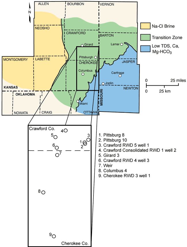
The Ozark aquifer is the single most important source of water in the Tri-state region of southeast Kansas, southwest Missouri, and northeast Oklahoma. Kansas water agencies and the Tri-State Coalition (a multi-state, nongovernmental organization consisting of water-related interest groups) are concerned that the available supply from the Ozark may become inadequate, rendered unusable, or require additional water treatment in the near future because of water-quality degradation. Many southeast Kansas and southwest Missouri water supplies withdraw water from wells that tap a 30-60-mi (48-96-km)-wide transition zone in the Ozark aquifer separating calcium-bicarbonate type ground waters with low dissolved solids to the east from sodium-chloride brines to the west (fig. 1).
Figure 1--Location of the nine supply wells included in this project and Ozark aquifer water-quality provinces within the Tri-state region. The boundary separating the Na-Cl brine from the transition zone represents a chloride concentration of 2,500 mg/L, and the line separating the transition zone from the low TDS water is the Pennsylvanian-Mississippian boundary outcrop (Macfarlane and Hathaway, 1987).
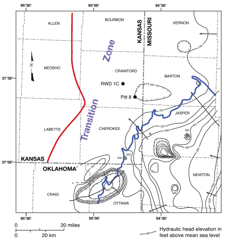
Two earlier regional studies indicated significant short- and long-term changes in the chemical quality of produced water from wells within or near the Ozark aquifer transition zone. Darr (1978) used 1966-1976 chloride data collected from public water supplies to infer the eastward movement of brackish water into Barton, Vernon, and Bates counties in southwestern Missouri. Macfarlane and Hathaway (1987) noted increases in the concentrations of sodium and chloride in the water produced from well 1 of the now defunct Crawford County RWD 7 between 1972 and 1980. Long-term pumping from the confined aquifer has significantly reduced and in some areas has reversed the hydraulic head gradient, which is generally from east to west across the water-quality transition zone in the Ozark aquifer. Development has produced coalesced cones of depression on the potentiometric surface within or near the transition zone in the Pittsburg, Kansas, and Miami, Oklahoma, areas (fig. 2; Macfarlane and Hathaway, 1987; Gillip et al., 2007). Macfarlane and Hathaway (1987) suggested that hydraulic head gradient reversals and increases in the vertical hydraulic head gradient could potentially induce the reported increases in chloride.
Figure 2--The 2006 Ozark aquifer potentiometric surface map of the Tri-state region with the water-quality transition zone in southeast Kansas and southwest Missouri. The heavy red and blue lines define the area of the saltwater to freshwater transition zone. The black dots labeled RWD 1C and Pittsburg 8 are the approximate locations of Crawford Consolidated RWD 1 well 2 and Pittsburg well 8, respectively. From Macfarlane and Hathaway (1987) and Gillip et al. (2007).
To better understand the impact of pumping on water quality, a project was initiated in 2006 that focused on nine public supply wells that withdraw water from the transition zone within the Ozark aquifer in southeast Kansas (fig. 1; table 1). Historic water-quality data were available for six of the nine wells from regional surveys reported in Macfarlane and Hathaway (1987; table 2). The objectives of the project were to 1) characterize the magnitude of fluctuations in the geochemistry of produced water from these wells based on samples collected monthly and repeatedly during the extended pumping of a single well, 2) assess long-term changes in the geochemistry of produced water from these wells since 1979-1980, and 3) use the results to better understand the causes of the short- and long-term changes in the geochemistry of the waters produced from these wells.
Table 1--Water-supply wells sampled in this project.
| Well Name | PLS Location1 | Well Depth (ft [m]) |
Ozark Aquifer Thickness Penetrated (ft [m]) |
Source(s) Tapped2 |
|---|---|---|---|---|
| Cherokee RWD 3 well 1 | SWSWSE sec. 17, T. 34 S., R. 24 E. | 1,050 (320) | 530 (162) | O |
| Columbus 4 | NENENW sec. 13, T. 32 S., R. 23 E. | 1,785 (544) | 747 (228) | S,O, SF |
| Crawford Cons. RWD 1 well 2 | SESESE sec. 2, T. 30 S., R. 24 E. | 1,013 (309) | 348 (106) | O |
| Crawford RWD 4 well 3 | NENENE sec. 16, T. 31 S., R. 24 E. | 970 (296) | 342 (104) | O |
| Crawford RWD 5 well 1 | SESWSW sec. 23, T. 30 S., R. 25 E. | 1,045 (319) | 615 (187) | S, O |
| Girard 3 | NESENE sec. 21, T. 30 S., R. 24 E. | 1,165 (355) | 445 (136) | O |
| Pittsburg 8 | NENESE sec. 28, T. 30 S., R. 25 E. | 1,050 (320) | 550 (168) | O |
| Pittsburg 10 | NESESE sec. 28, T. 30 S., R. 25 E. | 1,052 (321) | 550 (168) | O |
| Weir | SWSESW sec. 27, T. 31 S., R. 24 E. | 920 (280) | 300 (91) | P,S,O |
| 1Public Land Survey 2Aquifers sourced by the supply wells: P = Pennsylvanian, S = Springfield Plateau, O = Ozark, and SF = St. Francois |
||||
Table 2--Chemical analyses of water samples collected in 1979-1980 from water-supply wells included in this project.
| Well Name | Date Sampled |
TDS (mg/L) |
Ca (mg/L) |
Mg (mg/L) |
Na (mg/L) |
K (mg/L) |
Sr (mg/L) |
HCO3 (mg/L) |
SO4 (mg/L) |
Cl (mg/L) |
|---|---|---|---|---|---|---|---|---|---|---|
| Pittsburg 10 | 4/18/1979 | 577 | 65 | 27 | 48 | 5.0 | 0.79 | 325 | 68 | 38 |
| 9/26/1979 | 601 | 69 | 28 | 54 | 4.1 | 0.73 | 324 | 80 | 41 | |
| 5/15/1980 | 446 | 62 | 31 | 55 | 4.6 | 0.85 | 326 | 81 | 41 | |
| Crawford RWD 5 well 1 | 4/18/1979 | 468 | 42 | 19 | 58 | 3.6 | 0.51 | 265 | 21 | 58 |
| 9/26/1979 | 487 | 45 | 19 | 61 | 3.1 | 0.52 | 271 | 27 | 60 | |
| 5/14/1980 | 365 | 46 | 22 | 62 | 3.8 | 0.56 | 275 | 26 | 58 | |
| Crawford Cons. RWD 1 well 2 (Formerly Crawford RWD 7 well 2) |
10/7/1980 | 625 | 71 | 32 | 111 | 8.9 | 1.37 | 341 | 87 | 135 |
| Weir | 4/19/1979 | 546 | 60 | 27 | 43 | 6.0 | 0.95 | 318 | 53 | 37 |
| 9/24/1979 | 567 | 62 | 28 | 51 | 5.0 | 0.86 | 319 | 63 | 37 | |
| 5/12/1980 | 417 | 58 | 32 | 50 | 5.7 | 1.01 | 319 | 65 | 38 | |
| Columbus 4 | 9/25/1979 | 743 | 56 | 28 | 123 | 7.3 | 1.42 | 329 | 78 | 119 |
| Cherokee RWD 3 well 1 | 4/19/1979 | 594 | 44 | 20 | 115 | 5.5 | 1.07 | 189 | 28 | 191 |
| 9/20/1979 | 644 | 48 | 24 | 126 | 6.1 | 1.19 | 195 | 39 | 204 | |
| 5/13/1980 | 544 | 46 | 24 | 122 | 6.4 | 1.20 | 195 | 38 | 200 |
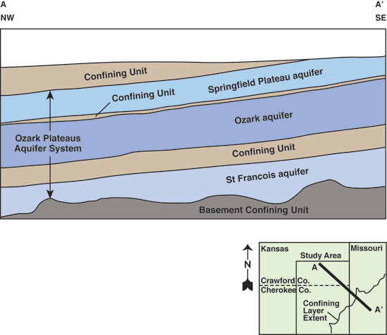
The Tri-state region is located astride the boundary between the Ozark Dome in Missouri and the Cherokee basin in Kansas. The bedrock units generally dip westward at approximately 20 ft/mi (3.75 m/km; figs. 3-4; Macfarlane and Hathaway, 1987). The Ozark Plateaus aquifer system in southeast Kansas and western Missouri consists of karstic and fractured Mississippian, Lower Ordovician, and Upper Cambrian carbonate rock units and has been subdivided into the Springfield Plateau, Ozark, and St. Francois regional aquifers (Jorgensen et al., 1993; Macfarlane, 2000; table 3). The Springfield Plateau aquifer framework consists of Mississippian limestones and dolomitic limestone, whereas the Ozark consists primarily of Lower Ordovician and Upper Cambrian dolostones with quartzose sandstones most prominently developed within the Roubidoux Formation and at the base of the Gasconade Dolomite. Sandstones of the Roubidoux Formation rest on a regional unconformity developed at the top of the Gasconade Dolomite (Jorgensen et al., 1993). The rocks of the Roubidoux, Gasconade Dolomite, and Potosi formations are considered to be the most productive sources of water (Imes and Emmett, 1994). Most of the supply wells sampled in this project withdraw water from only the upper 600 ft (183 m) of the aquifer and do not extend below the Gasconade (table 1). Dissolution along fractures and bedding planes is the primary process by which secondary permeability has developed in the carbonate rocks, whereas sandstone-matrix permeability depends on the size, sorting, and degree of cementation of the grains (Imes and Emmett, 1994). As a result of these factors, the permeability of the Ozark aquifer is likely to vary over several orders of magnitude across its thickness (Doveton, 1986). Wells in southeast Kansas do not use the St. Francois aquifer as a source of water and as a result very little is known about it.
Figure 3--Contour map of the elevation of the top of the Ozark aquifer in parts of southeast Kansas and adjacent southwest Missouri showing the location of the Pittsburg well field on the crest of the Pittsburg anticline (from Macfarlane and Hathaway, 1987).
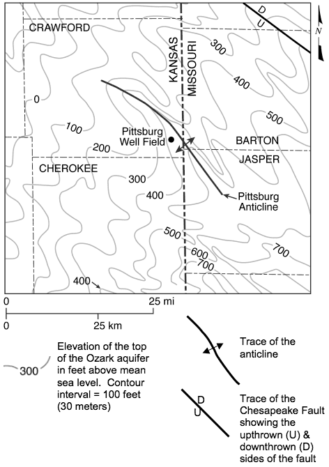
Table 3--Bedrock and hydrostratigraphic units in the study area modified from Jorgensen et al. (1993).
| System/Subsystem | Series | Rock Unit | Hydrostratigraphic Unit | |
|---|---|---|---|---|
| Pennsylvanian | Middle Pennsylvanian | Marmaton Group Cherokee Group |
confining unit | |
| Mississippian | Undifferentiated | - | Ozark Plateau Aquifer System |
Springfield Plateau aquifer |
| Northview Shale Compton Limestone |
confining unit | |||
| Ordovician | Lower Ordovician | Jefferson City Dolomite Roubidoux Formation Gasconade Dolomite |
Ozark aquifer | |
| Cambrian | Upper Cambrian | Eminence Dolomite Potosi Formation |
||
| Derby and Doe Run Dolomites | confining unit | |||
| Bonneterre Dolomite Lamotte Sandstone |
St. Francois aquifer | |||
| Precambrian | - | - | confining unit | |
Ozark Plateaus aquifer system thickness ranges from 1,735 ft (529 m) in the Joplin, Missouri, area to 1,390 ft (424 m) at Parsons, Kansas (Macfarlane and Hathaway, 1987). The average thickness of the Ozark and Springfield Plateau aquifers is close to 1,000 ft (305 m) and 350 ft (114 m), respectively, within the study area (Imes and Emmett, 1994). The Springfield Plateau aquifer is unconfined across much of southwest Missouri and the southeast corner of Cherokee County, Kansas. Elsewhere, the Ozark Plateaus aquifer system is confined above by a sequence of Carboniferous (Pennsylvanian) shales and limestones and below by rocks of Precambrian age (fig. 4). One or more low-permeability units separate the Springfield Plateau from the Ozark aquifer in southern Crawford and Cherokee counties. Confining-layer thickness is generally less than 20 ft (6.1 m) in these counties (Macfarlane and Hathaway, 1987).
Figure 4--Schematic northwest to southeast cross section of the subsurface from southeast Kansas into southwestern Missouri generalized from Macfarlane and Hathaway (1987) showing the arrangement of aquifers and confining units in the Ozark Plateaus aquifer system based on well-log data. The freshwater-transition zone boundary is shown along the top of the figure.
Pre-development ground-water flow in both aquifers is generally in a northwesterly direction from southwest Missouri into the southeast Kansas study area (Macfarlane et al., 1981; Imes and Emmett, 1994). Recharge to the confined Ozark aquifer comes primarily from leakage moving downward from the Springfield Plateau aquifer across the confining layer (Imes and Emmett, 1994). Localized concentrations of high-yielding supply wells in northeast Oklahoma, southwest Missouri, and southeast Kansas, including the Pittsburg area, have produced extensive cones of depression in the Ozark aquifer potentiometric surface (fig. 2; Macfarlane et al., 1981; Macfarlane and Hathaway, 1987; Gillip et al., 2007). Declines in the Ozark aquifer potentiometric surface since pre-development exceed 150 ft (45.7 m) at some locations in the Pittsburg area (Stramel, 1957; Macfarlane and Hathaway, 1987; Gillip et al., 2007).
Where the Springfield Plateau aquifer is unconfined, ground-water quality in the underlying Ozark aquifer varies from calcium-bicarbonate to a mixed cation-bicarbonate type with a total dissolved solids (TDS) concentration of generally less than 500 mg/L (fig. 1; Macfarlane and Hathaway, 1987). Calcium/magnesium equivalent ratios in Ozark aquifer ground waters are typically 1-2, consistent with the predominantly dolomitic composition of the aquifer. Ratio values near 3 in water from wells located where the Springfield Plateau is the near-surface aquifer suggest leakage from the limestones of the overlying Springfield Plateau aquifer. The calcium/magnesium equivalent ratio range is from 0.66 to 4.00 with a median value of 1.19 in water from wells in areas of southwestern Missouri where the Springfield Plateau aquifer is overlain by Pennsylvanian strata (Darr, 1978). Water type in the Springfield Plateau aquifer is generally calcium-bicarbonate with dissolved solids concentrations less than 1,000 mg/L where the aquifer is unconfined, but changes to a sodium-bicarbonate with dissolved solids concentrations ranging up to several thousand mg/L or more where the aquifer is confined by overlying Pennsylvanian strata (Macfarlane and Hathaway, 1987; Feder et al., 1969; Darr, 1978). Dissolved hydrogen sulfide levels are less than 0.2 mg/L.
To the west in the Cherokee basin of southeast Kansas and northeast Oklahoma, the Ozark Plateaus aquifer system is in the deep subsurface and isolated hydraulically from the near-surface sources of freshwater recharge. Here, the ground water in the Ozark aquifer is a sodium-chloride brine with a high TDS concentration that generally exceeds 10,000 mg/L (fig. 1). The brine environment is chemically reducing and the dissolved hydrogen sulfide concentration ranges up to 100 mg/L where some of the brines are associated with oil fields (Macfarlane and Hathaway, 1987).
Within the transition zone that separates the saline from freshwater in the Ozark aquifer, the ground-water type changes laterally from calcium, magnesium-bicarbonate, and mixed cation-bicarbonate on the east to sodium-chloride on the west (fig. 1). Macfarlane and Hathaway (1987) noted that water samples from wells tapping the Ozark aquifer near the updip edge of the Pennsylvanian outcrop belt exhibited many of the geochemical changes associated with the transition from freshwater to brine. Hence, they set the freshwater-transition zone boundary in the Ozark aquifer to coincide with the updip edge of the Pennsylvanian outcrop belt. The brine/transition zone boundary shown in figs. 1 and 2 was set arbitrarily as the 10,000 mg/L TDS isocon, the limit that defines usable water in Kansas. Data are not available to determine the vertical variability in water quality from top to bottom within the Ozark aquifer in the transition zone. Based on a review of the data from the drilling of shallower Ozark wells, Macfarlane and Hathaway (1987) concluded that the complexity of the aquifer framework and the regional and local structural fabric probably precludes a simple picture of increasingly saline water with depth within the transition zone.
Water pumped from wells completed in the Ozark aquifer transition zone contains measurable amounts of hydrogen sulfide ranging from trace amounts near the eastern side up to 40 mg/L near the western side, and sulfate concentrations from 110 mg/L near the eastern edge to 3 mg/L near the western edge. The simultaneous occurrence of these constituents in produced water indicates either that 1) a state of chemical equilibrium exists, 2) a very slow transition is occurring in the oxidation state of sulfur in the aquifer, or 3) pumping has produced a disequilibrium blend of waters from different parts of the aquifer (Macfarlane and Hathaway, 1987). Macfarlane et al. (1981) suggested that mixing different amounts of the water from the freshwater and brine sources could approximate the chemistries of water samples from the transition zone of the Ozark aquifer.
Prev Page--Start || Next Page--Methodology
Kansas Geological Survey
Placed online June 25, 2010
http://www.kgs.ku.edu/Current/2010/Macfarlane/02_intro.html
email:webadmin@kgs.ku.edu