Kansas Geological Survey, Current Research in Earth Sciences, Bulletin 250, part 1
Prev Page--Structural Directions || Next Page--Petroleum Implications
![]()
![]()
![]()
Kansas Geological Survey, Current Research in Earth Sciences, Bulletin 250, part 1
Prev Page--Structural Directions ||
Next Page--Petroleum Implications
![]()
Identification of structural "grain" and linear structures in the deep subsurface requires integration of several data sources. One of the most powerful of these data sources is drainage pattern analysis, particularly in areas where there has been a history of reactivation of older structural trends, and when coupled with other tools. In this study, drainage pattern analysis of major stream segments was combined with earlier subsurface geologic mapping and slope changes (Cole, 1976), and potential fields data (gravity and magnetic data of Lam and Yarger, 1989, and Yarger, 1989; see also Kruger, 1996). Previous studies in eastern Kansas have identified structural elements and directions that are incorporated in and corroborated by this study (Baars, 1995; Berendsen, 1997; Berendsen and Blair, 1986; and Burchett et al., 1983).
Inden and Frush (2002) and Silverman (2002) have recent documented examples of use of potential field information for interpretation of structural "grain." The underlying Precambrian framework of Kansas is a highly fractured complex of crystalline rocks and younger, still Precambrian, detrital sediments that have been faulted and eroded prior to the Sauk transgression (latest Precambrian through Lower Ordovician). The fractures are in two major sets, north-northeast trending and northwest trending. The north-northeast-trending fractures are the major controls for the Midcontinent Rift System, and include the present day Nemaha Ridge and parallel structures such as the Abilene anticline (fig. 6; plate 1). West of the Nemaha Ridge and the Rift System, the trend is more northeast than north-northeast, and the fracture sets appear to be normal conjugate shears.
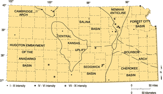
Figure 6--Generalized geologic structures of Kansas, showing the historical outlines of major structures and epicenters of major earthquakes. Modified from Merriam (1956), with earthquake epicenter additions from Steeples (1996). Steeples also documented locations of epicenters of microearthquakes, many associated with the Nemaha Ridge and the Central Kansas uplift.
Subsequent Phanerozoic tectonic activity has undoubtedly modified Precambrian structures. Berendsen (1997) cites tectonic events that terminate the Sauk Sequence, Tippecanoe Sequence, Lower Kaskaskia Sequence (Gerhard et al., 1982), and Upper Kaskaskia Sequence. All these events can be related to craton margin events, whose stress is reflected in strain within the craton (Gerhard et al., 1991) (see also brief note by Wilson and McCauley, 1989).
The relative frequency of these events confuse dating the origins of the two major tectonic "grain" trends. Some Midcontinent Rift faults are offset by northwest-trending faults, but this may reflect only the most recent relative motion along these faults. As Berendsen (1997) has pointed out, there is a lateral component to some of the stress fields, so that it is not possible to date the origin of the fractures.
It is apparent from plate 1 that the major basement structures of Kansas are bounded by fractures that may have both Precambrian and Phanerozoic histories. As pointed out by Hambleton (1989), along the rift system sedimentary thickness variation indicates that at least some of these fractures had Phanerozoic movement. Rhombic blocks are developed by conjugate shearing. Typically these blocks have a slight vertical rotation, giving rise to subtle influence on deposition, especially in carbonate settings. Junctions of faults may exhibit topographic/structural behavior at odds with surrounding terranes. One example of this phenomenon is the junction of the two faults interpreted from Arkansas River drainage pattern on plate 1. Here, the apparent junction is also the location of the Cheyenne Bottoms Wildlife Refuge, a large wetlands (approx. 19 mi2) that is geomorphically anomalous. There are many more fractures on and along the Central Kansas uplift than have been mapped. Plate 1 is not designed to identify every possible fracture, but rather to identify the major detectable fractures and their apparent density. It is clear from the linear pattern of oil drilling on the Central Kansas uplift that additional fractures are present (see also Baars and Watney, 1991, and Berendsen, 1999).
Relative direction of motion along the fractures is unknown. The sense of direction has probably changed over time, the last major movement being post-Mississippian (Ancestral Rocky Mountain tectonism). Roehl et al. (1989) identified reversed last motion on the Lyons anticline in Rice County, Kansas, at the southeastern end of the Central Kansas uplift in a seismic profile. Their cross section shows significant thickness variation in lower Paleozoic rocks near the faults, indicating that the structural history is likely complex (see also Carr et al., 1995). It is unclear that there has been any Laramide re-adjustment along any of these planes. This is congruent with knowledge of other cratonic basins of Colorado and North Dakota (Baars, 1966; Gerhard, 1967; Gerhard et al., 1987). Identification of reversal of sense of motion along major structures and thickness changes in associated sedimentary units is key to diagnosis of recurrent movement on older planes of weakness.
Wrench-fault motion is much more difficult to identify. As Berendsen (1997) has pointed out, there is a lateral component to some Kansas stress fields, the full extent of which cannot be determined. As a purely speculative concept, it might be possible that the extensive northwest-trending Humbolt Fault Zone, fronting the east flank of the Nemaha Ridge, together with elements of the Midcontinent Rift, has a significant strike-slip (wrench) component. If so, the Bourbon Arch (Merriam, 1963) could be the offset extension of the Central Kansas uplift, but that motion would require a cumulative relative offset of approximately 66 mi, and is suggested here only to illustrate the conceptual power of fracture reconstruction. Further detailed study of the history of specific sets of fractures may lead to better understanding of the potential for economic mineral and energy deposits along the Nemaha and much of the rest of Kansas. Berendsen (1997) suggests that an extension of the Missouri Gravity Low that accommodates the offset between the Kansas and Nebraska sections of the Midcontinent Rift can be traced under the rhyolites of the St. Francois Mountains of Missouri.
If accurate, this could date the origin of the northwest-trending faults as older than the 1,480 MA age of the rhyolites. Very recently, McBee (2003) suggested significant strike motion along the entire length of the Nemaha, from Oklahoma to Nebraska.
Prev Page--Structural Directions || Next Page--Petroleum Implications
Kansas Geological Survey
Web version Sept. 15, 2004
http://www.kgs.ku.edu/Current/2004/Gerhard/05_phan.html
email:webadmin@kgs.ku.edu