Kansas Geological Survey, Current Research in Earth Sciences, Bulletin 250, part 1
Prev Page--Introduction || Next Page--Structural Directions
![]()
![]()
![]()
Kansas Geological Survey, Current Research in Earth Sciences, Bulletin 250, part 1
Prev Page--Introduction ||
Next Page--Structural Directions
![]()
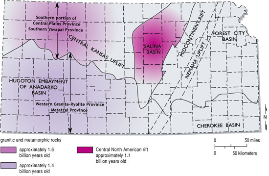
The Phanerozoic tectonic pattern that controls sedimentation and diagenesis in Kansas is a direct reflection of its Precambrian history. In consequence, a brief review of that history is appropriate to understanding the development of new play concepts. Bickford and Van Schmus have worked for many years to document the nature, lithology, and age of crystalline and other Precambrian rocks underlying the sedimentary cover of Kansas (Bickford et al., 1979; Van Schmus and Bickford, 1981; Bickford et al., 1986; Van Schmus et al., 1987; Van Schmus, 1992; Van Schmus et al., 1993; Van Schmus et al., 1996) (fig. 1). Some relationship exists between the Precambrian terranes and Kansas structures (fig. 2), particularly between the Central North American Rift and the present day Nemaha uplift and Salina basin. The Central Kansas uplift parallels the boundary between the Western Granite-Rhyolite Province and the Central Plains Province.
Figure 1--Map of southwestern U.S. geologic Precambrian elements, showing provincial names and ages. Modified from CD-ROM working group (2002). The Southern Yavapai Province is the equivalent of the southern portion of Central Plains Province of Van Schmus et al. (1987) and the Mazatzal Province is the equivalent of the Western Granite-Rhyolite Province of Van Schmus et al. (1987). Carlson and Treves (2000) suggest that Southern Yavapai deformation occurred about 1.67 Ga, and Mazatzal deformation occurred about 1.61 Ga.
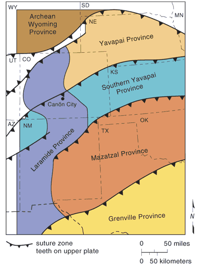
Figure 2--Generalized map of Precambrian terranes in Kansas, showing ages and lithologies, with major Kansas historical structures identified. Modified from Newell et al., 1987. Southern portion of Central Plains Province (Van Schmus et al., 1987); Southern Yavapai Province (CD-ROM Working Group, 2002); Western Granite-Rhyolite Province (Van Schmus et al., 1987); Mazatzal Province (CD-ROM Working Group, 2002).
Although early focus was on possible extensional origin of the Kansas Precambrian suite, current thought (Van Schmus et al., 1996; Carlson, 1999, 2001) is that these rocks record the last of a series of Paleoproterozoic (greater than 1.55 Ga) and Mesoproterozoic (younger than 1.55 Ga) accretionary episodes, the last additions of juvenile crust to the region. Cooling of the region by 1.3 Ga should have permitted brittle fractures to develop (Van Schmus, personal communication, 2003). several interpretations of additional accretionary belts (Carlson and Treves, 2000; Carlson, 2001) and variations about where the major boundary contacts between belts occur (CD-ROM Working Group, 2002; Carlson, 2001; Carlson and Treves, 2000; Newell et al., 1987) have been made. Because a significant active structural discontinuity between the accretionary terranes does not seem to exist, the exact placement of the boundary is likely not important to this study. The presence of patches of metamorphosed sedimentary rocks throughout the approximate 1.6 Ga-old northern terrane of Newell et al. (1987) in Kansas (southern portion of the Central Plains Province of Van Schmus et al. [1987]) suggests that incomplete assimilation of these former sedimentary rocks is unique to the northern terrane. The southern granitic province (ca. 1.4 Ga old) (the Western Granite-Rhyolite Province of Van Schmus et al. [1987]) is younger and has so far yielded no metasedimentary rocks. Thus the boundary may be defined by the presence or absence of metasedimentary rocks (given sufficient sampling points).
CD-ROM Working Group (2002) maps (fig. 1) suggest that their Southern Yavapai Province includes both the southern portion of the Central Plains Province of Van Schmus et al. (1987) and the closest Precambrian exposures in Fremont County, Colorado, where a thick section of meta-sedimentary rocks is exposed. These rocks apparently represent at least one full continental-scale sedimentary sequence. Although it is not possible to develop a strong correlation between Kansas Precambrian rocks and the Colorado rocks except on an approximate age of metamorphism and intrusion, it may be possible to interpret a more detailed geologic history of the Central Plains Province than is possible from the cuttings and cores that have been collected in the Kansas portion of the province. It is especially tempting to theorize correlation of quartzites of the Gorham field area (Walters, 1991) with those exposed in the southern Rocky Mountains. Van Schmus (1992) argued that the northern portion of the Central Plains Province (Orogen) is an eastward extension of a primary crustal accretion complex found in northern Colorado; perhaps the southern portion is represented in central and southern Colorado exposures (CD Working Group, 2002).
The last Precambrian rock generation occurred in the Late Proterozoic, in the Midcontinent Rift System. Basic sills, basaltic flows, and arkosic sedimentary rocks with some organic shales (Berendsen et al., 1988) were emplaced during 1.2-1.1 Ga (Van Schmus et al., 1987; Van Schmus, 1992).
The change in tectonic style from accretion of successive volcanic arcs to extensional tectonics (formation of the Midcontinent Rift System) appears to have set the stage for a brittle-failure Phanerozoic structural style. While it is not possible to accurately date the formation of most fractures in the basement rocks of Kansas, study of better-exposed rocks elsewhere can assist in interpretation of structural history. Over the last four decades, studies have documented the influence of early structural failure upon Phanerozoic sedimentation and structural development (Gerhard, 1967; Gerhard et al., 1982; Gerhard et al., 1987; Gerhard and Anderson, 1988; Gerhard et al., 1991; see also references cited in those publications).
Baars et al. (1995) suggested that the entire North American craton was fractured by wrench faults during the later Proterozoic, prior to 1.2-Ga rifting. Gerhard et al. (1991) have argued that movement along wrench faults in the Williston basin has generated the major petroleum-producing structures in that basin, and formed many of the Wyoming Rocky Mountain structures as well. Whether those arguments will remain viable in the future is uncertain, but the concepts have led to significant petroleum discoveries and explanations for patterns of both production and lack of production. Berendsen (1999) has documented in detail rhombic fracture sets in northeastern Kansas (see also Plate 1, this paper). Marshak and Paulson (1996) also argue that Precambrian wrench-fault-originated rhombic blocks are precursors to Phanerozoic structures. Carlson (1999) has argued that many cratonic structures are simply rejuvenation of pre-Phanerozoic weakness planes, an argument with which this writer has no quarrel. The principle embodied in this discussion may be stated:
Structural distortion of previously consolidated cratonic plates is accommodated largely by rejuvenation of planes of weakness originally formed after plate cooling. The relative sense of motion along these fractures will vary with the directions of stress applied at the margins of the plate during later accretionary or rifting events.
The Midcontinent Rift Sytem appears to have a present day vertical relief of over 20,000 ft; that is, it contains extrusive, layered intrusive and sedimentary rocks of approximately 20,000 ft in thickness, deposited in grabens and crustal gaps (Berendsen et al., 1988; Serpa et al., 1989; Woelk and Hintze, 1991, 1995; Van Schmus et al., 1996). Van Schmus (1992) has theorized that the stratigraphic section of basic intrusives and red sandstone encountered in the Texaco #1-31 Poersch well (Washington County, northeastern Kansas) is reversed by thrust faulting.
Van Schmus' evidence for reversal of lithologic section is
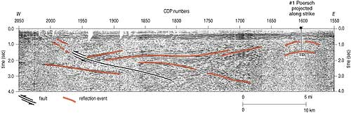
Because the underlying sedimentary rocks in Kansas have not been dated nor their polarity identified, it remains possible that in Kansas there is a lower detrital section and the upper detrital sediments, coeval with those of the Lake Superior region, have been eroded. However, correlations made by Van Schmus suggest strongly that the section is thrusted. COCORP data (fig. 3) illustrates possible thrust faulting, along with possible sedimentary "packages."
Figure 3--Portion of COCORP seismic section across Midcontinent Rift System (MRS), showing structural complexity and depth of feature. Length of section is approximately 56 mi (90 km). Depth is two-way travel times in seconds. Major reflectors colored. A larger version of this figure is available.
If thrusting occurred, the mechanics of conducting overthrusting in the confined space of a graben are intriguing. There are two obvious models. The first requires continued downdropping and tilting of the floor of the graben, fracturing the accumulated section. Mass movement of the relatively elevated mass over the downdropped mass, with subsequent erosion of the sediments on the top of the upper plate can accomplish the reversal of section without any re-orientation of stress fields.
The second model requires driving the thrust within the graben by significant crustal shortening, prior to deposition of Phanerozoic rocks. This model might result in creation of additional splayed thrust faults around the margins of the rift as well as shortening the crust within the riftIf present, these splays might be rejuvenated at a later date.
Carlson (1997) argues that the central graben topography was reversed so that central horsts existed with accompanying downdropped flanking graben basins. Basalt associated with the horst development is dated at 990 Ma. This interpretation requires vertical tectonics rather than compressional thrusting and does not provide for the inversion of sediment and volcanic packages as argued by Van Schmus (1992).
A clear gap in the continuity of the rift system exists near the Kansas-Nebraska border (Carlson, 1997). The lithologic sequence in the Kansas portion of the rift system possibly results from differences in process and history from that of the remainder of the western limb of the MRS in Nebraska through Minnesota; certainly, a difference in prior Precambrian tectonic history is found within these areas. Perhaps the Kansas segment is more aligned with the detailed history of the Oklahoma aulacogen, and this discussion compares non-correlative sections. Interpretation of COCORP seismic information suggests, but does not prove, thrust faulting.
Prev Page--Introduction || Next Page--Structural Directions
Kansas Geological Survey
Web version Sept. 15, 2004
http://www.kgs.ku.edu/Current/2004/Gerhard/03_precamb.html
email:webadmin@kgs.ku.edu