![]()
The primary focus of this study was to determine landslide susceptibility by examining the causal factors. The triggering mechanisms for landslides in the Atchison study area were not determined as part of this study. Triggering mechanisms are very important in studies of the initiation of individual landslides and in determining the probability of future landslides.
Table 2. Geologic units and recent landslides in the vicinity of Atchison, Kansas.
| Geologic unit | Number of landslides | Percentages of landslides | Area of exposure (km2) | Landslides per unit area of exposure (1/km2) |
|---|---|---|---|---|
| Quaternary alluvium | 6 | 3.3% | 38.73 | 0.16 |
| loess | 7 | 3.8% | 29.40 | 0.24 |
| glacial drift | 30 | 16.3% | 98.78 | 0.30 |
| Atchison formation | 7 | 3.8% | 0.27 | 25.64 |
| Topeka Limestone | 0 | 0% | 0.14 | 0 |
| Calhoun Shale | 0 | 0% | 0.94 | 0 |
| Deer Creek Limestone | 1 | 0.5% | 6.79 | 0.15 |
| Tecumseh Shale | 17 | 9.2% | 10.69 | 1.59 |
| Lecompton Limestone | 8 | 4.4% | 6.42 | 1.25 |
| Kanwaka Shale | 57 | 31.0% | 7.68 | 7.42 |
| Oread Limestone | 28 | 15.2% | 2.15 | 13.02 |
| Lawrence Formation | 23 | 12.5% | 0.39 | 58.97 |
| Totals | 184 |
The geologic unit in the study area with the most landslides per unit area of exposure is the Lawrence Formation (table 2). This finding agrees with the general perception of the Lawrence Formation as one of more landslide-prone rock units in northeast Kansas (F. Wilson, personal communication, 1997; D. Thompson, personal communication, 1999). After the Lawrence Formation, the most susceptible units are the Atchison formation, the Oread Limestone, and the Kanwaka Shale.
The distribution of slope angles within a geologic unit's outcrop area also affects the susceptibility ranking of each unit. Glacial drift is located at the tops of hills and in the western portion of the study area where gentle slopes dominate. The Lawrence Formation is located at the base of the Missouri River bluffs where steep slopes dominate. Thus, the Lawrence Formation is in an area that is more prone to landslides because of slope angle. It would have been advantageous to normalize the number of landslides (table 2) by the area of exposure on slopes greater than 5 degrees, which is the minimum slope angle for landslides in the study area. However, the required slope data are currently unavailable.
Because the Oread Limestone has two limestone members with thicknesses of 2 m (6.4 ft) or more, it should be resistant to landslides. In the study area, however, the Oread Limestone is the third most susceptible rock unit, based on both the percentage of landslides and the landslides per unit area (table 2). Some of this is due to the fact that parts of the Oread Limestone were incorporated into landslides that involved the Lawrence Formation and Kanwaka Shale. Additionally the Snyderville Shale Member is a 3.8-m-thick (12.5-ft-thick) shale unit near the base of the Oread Limestone (table 1). Small landslides have been observed in the Snyderville Shale in Douglas County. The presence of the susceptible shales surrounding and within the Oread Limestone causes this formation to be susceptible to landslides.
The Atchison formation is composed of alluvium and is the second most important unit on the landslides per unit area list (table 2). The Atchison formation is exposed primarily along the south side of White Clay Creek (table 2). The exposure area is small, but the number of landslides is significant yielding a high value for the landslides per unit area. White Clay Creek flows at the base of the bluff where the Atchison formation is exposed. Thus, the landslides in the Atchison formation are the result of undercutting by White Clay Creek, and the susceptibility of the Atchison formation may be slightly lower on slopes that are not being undercut.
No recent landslides were mapped in the Calhoun Shale and the Topeka Limestone. The exposure area of these two formations is small (0.6% of the total study area), and the slopes in the exposure area are gentle. It is unknown whether these two units are involved in recent landslides in other portions of Atchison County. All the remaining units have at least one recent landslide, and thus it seems reasonable to assume that all the rock units could fail under the right conditions.
Shale units were associated with a high percentage of the recent landslides. Twenty-six shale samples were collected from outcrops by removing the upper weathered material to a depth where the shale showed clear bedding. Nonetheless, the samples should still be considered partially weathered. Additionally, a bias exists for collecting the fine-grained portions of the shale units. Thus, the data presented are not representative of the whole unit; for example, the Kanwaka Shale contains sand layers that were not sampled as part of the study.
The shale samples were subjected to a variety of soil analyses (table 3). They were analyzed for Atterberg limits--that is, the water-content boundaries between the semiliquid and plastic states (called the liquid limit) and between the plastic and semisolid states (called the plastic limit) (Jackson, 1997). Based on their Atterberg limits, most samples were classified as clays of low plasticity (CL) and clays of high plasticity (CH), using the Unified Soil Classification System (USCS) (table 3table 3). CL and CH soils have the behavior of clays due to the minerals present but may not necessarily contain high concentrations of clay-sized particles.
Table 3. Soil analyses performed on 44 samples.
| Atterburg limits | ||||||
|---|---|---|---|---|---|---|
| Rock unit | Liquid limit | Plastic limit | Plasticity index | USCS | Specific gravity | Activity |
| alluvium | ||||||
| landslides | 41.7-54.6 | 19.0-21.2 | 21.0-36.9 | CH,CL | 2.74 | 0.71-1.90 |
| loess | 27.0-50.2 | 18.3-23.2 | 4.2-31.1 | CL, ML, CH | 0.50-0.94 | |
| "Nortonville Clay" | 61.7-66.2 | 17.2-17.9 | 43.7-49.0 | CH | 0.99-1.08 | |
| glacial drift | 32.1-59.2 | 13.6-18.2 | 18.4-41.1 | CH, CL, SC | 0.80-1.34 | |
| Atchison formation | ||||||
| Topeka Limestone | ||||||
| Calhoun Shale | 49.6 | 22.5 | 27.2 | CL | 2.73 | 0.74 |
| Deer Creek Limestone | 37.4-60.1 | 18.4-24.0 | 19.0-36.1 | CH, CL | 2.75-2.85 | 0.71-0.86 |
| Tecumseh Shale | 41.2 | 25.8 | 15.4 | ML | 0.74 | |
| Lecompton Limestone | ||||||
| Kanwaka Shale | 36.2-65.1 | 21.2-26.1 | 15.1-39.0 | CH, CL | 2.74-2.83 | 0.43-0.84 |
| Oread Limestone | ||||||
| Lawrence Formation | 35.3-53.5 | 18.9-22.2 | 16.4-31.2 | CH, CL | 2.74-2.82 | 0.50-0.70 |
Table 4 shows that a high percentage of clay-sized fragments were observed in the Kanwaka Shale (up to 87% clay), the Lawrence Formation (up to 68%), and in recent landslides (up to 65%). Expansive clays were found in the clay minerals of the Kanwaka Shale. Expansive clays increase in volume as the moisture content increases. This leads to the degradation of the rock structure and the formation of soil from the shale (Ingram, 1953). Additionally, the expansive nature of the clays can weaken the soil, as the moisture content increases.
Table 4. Gradation for 44 samples of shale and unconsolidated units.
| ASTM gradation | |||||
|---|---|---|---|---|---|
| Rock unit | Gravel | Sand | Silt | Clay | Number of samples |
| alluvium | 0 | ||||
| landslides | 0.4-12.6 | 2.2-8.0 | 32.4-56.0 | 29.0-65.0 | 5 |
| loess | 0 | 0.3-10.0 | 59.6-79.0 | 11.0-39.8 | 6 |
| "Nortonville clay" | 0 | 1.5-4.5 | 45.0-49.0 | 49.5-50.0 | 2 |
| glacial drift | 0-6.5 | 28.5-55.4 | 17.5-36.7 | 24.0-35.4 | 5 |
| Atchison formation | 0 | ||||
| Topeka Limestone | 0 | ||||
| Calhoun Shale | 0 | 6.0 | 38.0 | 56.0 | 1 |
| Deer Creek Limestone | 0 | 5.0-8.0 | 38.0-59.0 | 33.0-57.0 | 4 |
| Tecumseh Shale | 0 | 7.5 | 59.0 | 33.5 | 1 |
| Lecompton Limestone | 0 | ||||
| Kanwaka Shale | 0-7.8 | 0.1-18.2 | 12.8-60.9 | 32.5-87.0 | 12 |
| Oread Limestone | 0 | ||||
| Lawrence Formation | 0-4.0 | 1.0-8.0 | 29.8-58.5 | 39.5-68.0 | 8 |
Six samples from the Kanwaka Shale were analyzed for their clay mineralogy using X-ray diffraction (XRD), and two samples were reanalyzed by K/T Geoservices to verify the results. All the samples contained a poorly crystallized, expandable material that included mixed-layer illite/smectite. Two samples contained an expandable mixed-layer chlorite/smectite. One sample contained some Ca-montmorillonite, which is expansive but not as expansive as Na-montmorillonite. Non-expansive clay minerals in the samples include illite, kaolinite, and chlorite.
The results of the XRD analysis were extrapolated to samples from other units by examining the Atterberg limits. The position that the Atterberg limits plot on a plasticity chart can be related to the clay mineralogy of a soil (Casagrande, 1948; Holtz and Kovacs, 1981). In this study, the liquid limit and plasticity index for each sample were plotted on a plasticity chart, which contained the ranges for montmorillonite, illite, kaolinite, and chlorite (fig. 12). Montmorillonite is an expansive clay mineral in the smectite group. The plasticity chart shows that the samples are composed of a mixture of montmorillonite and illite with some samples near each clay mineral. These results are in agreement with the XRD analysis of the six samples presented above. Underwood (1967) states that shales with clay fractions containing illite and montmorillonite have lower shear strengths and higher swelling potentials and are more prone to landslide problems than shales composed of kaolinite and chlorite.
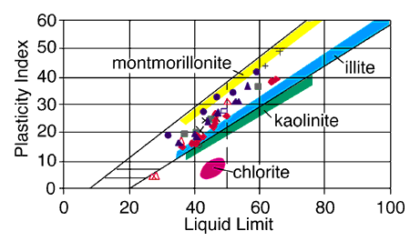
Fig. 12. A plasticity chart showing the relationship of the soil samples to clay mineralogy. The figure includes samples from the Lawrence Formation (blue triangles), the Kanwaka Shale (red diamonds), the Tecumseh Shale (black open diamond), the Deer Creek Limestone (green squares), the Calhoun Shale (blue open squares),glacial drift (blue circles), the "Nortonville Clay" (black pluses), loess (red open triangles), and landslides (black crosses). The points where Atterberg limits plot on plasticity charts relate to the dominant clay mineralogy of the sample (Casagrande, 1948; Holtz and Kovacs, 1981). The Atterberg limits of the Atchison samples plot in the area between montmorillonite, a smectite clay, and illite, with some samples having more illite and others more montmorillonite.
Activity values for the samples were also calculated (table 3). Activity is defined as the plasticity index divided by the percentage of clay-sized fragments in a sample (Skempton, 1953). Shales with activity values greater than 0.75 are prone to landslide problems (Underwood, 1967). With the exception of the Lawrence Formation, all the other geologic units tested had at least one sample with an activity value close to or greater than 0.75, indicating that all of these units can contribute to landslide problems.
Kansas Geological Survey
Web version December 22, 2000
http://www.kgs.ku.edu/Current/2000/ohlmacher/ohlmacher6.html
email:lbrosius@kgs.ku.edu