Kansas Geological Survey, Current Research in Earth Sciences, Bulletin 244,
part 3
The Relationship Between Geology and Landslide Hazards of Atchison, Kansas, and Vicinity--Fig. 12
![]()
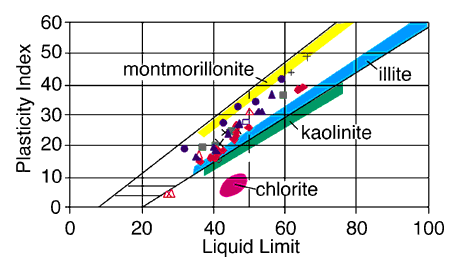
Fig. 12. A plasticity chart showing the relationship of the soil samples to clay mineralogy. The figure includes samples from the Lawrence Formation (blue triangles), the Kanwaka Shale (red diamonds), the Tecumseh Shale (black open diamond), the Deer Creek Limestone (green squares), the Calhoun Shale (blue open squares),glacial drift (blue circles), the "Nortonville Clay" (black pluses), loess (red open triangles), and landslides (black crosses). The points where Atterberg limits plot on plasticity charts relate to the dominant clay mineralogy of the sample (Casagrande, 1948; Holtz and Kovacs, 1981). The Atterberg limits of the Atchison samples plot in the area between montmorillonite, a smectite clay, and illite, with some samples having more illite and others more montmorillonite.